The first national park in Denmark proper was Thy National Park (Danish: Nationalpark Thy), created in 2008. It is located in Thisted Municipality, Nordjylland. The park is a narrow stretch of land along the North Jutlandic Island's west coast from Hanstholm southward to Agger Tange, excluding Hanstholm, Klitmøller, Nørre Vorupør, Stenbjerg and Agger. Thy National Park is named after Thy, an area that includes not only today's national park but also adjacent land further east. The park has dunes, heath, forests and grassland and also covers several small lakes and a small part of the Limfjord, which is the fjord that separates the North Jutlandic Island from the Cimbrian Peninsula.
In 2020, work began on establishing nature national parks.[5] These will strictly be on land owned by the Danish state, unlike the ordinary national parks where some parts are on private and municipal land. This gives the state greater control over the full area in the nature national parks and allows greater protection of the nature.[6] Fifteen nature national parks are planned, including five that are part of the original national parks (Gribskov within Kongernes Nordsjælland National Park, Hellerup Forest and Teglstrup Hegn within Kongernes Nordsjælland National Park, Bidstrup Forests within Land of the Scylding National Park, Mols Bjerge within Mols Bjerge National Park, and Hanstholm within Thy National Park).[5]
Greenland has had its own national park since 1974. The Northeast Greenland National Park stretches across three fifths of the northern parts of Greenland's east coast and, since its expansion in 1988, two thirds of the eastern parts of Greenland's north coast. Bounded by the coasts, the park covers the island's entire north-eastern quarter, all of which is almost uninhabited.[7]
Like Greenland, the Faroe Islands forms another autonomous region of the Kingdom of Denmark, but contains no national parks.
The Schleswig-Holstein Wadden Sea National Park is a national park in the Schleswig-Holstein area of the German Wadden Sea. It was founded by the Parliament of Schleswig-Holstein on 1 October 1985 by the National Park Act of 22 July 1985 and expanded significantly in 1999. Together with the Lower Saxon Wadden Sea National Park, the Hamburg Wadden Sea National Park and those parts of Elbe estuary which are not nature reserves, it forms the German part of the Wadden Sea.
The North Jutlandic Island, Vendsyssel-Thy, or Jutland north of the Limfjord, is the northernmost part of Denmark and of Jutland. It is more common to refer to the three traditional districts Vendsyssel, Hanherred and Thy, however. The area has been intermittently a tied island, and during modern times was not surrounded by water until a storm in February 1825, which severed the region from the remainder of Jutland and caused a water connection between the North Sea and the western end of the Limfjord. Hence it is traditionally regarded as a part of Jutland rather than a separate island.
Arresø is the largest lake, by area, in Denmark. It covers 40,72 km² and is situated on the island of Zealand 43 kilometers northwest of Copenhagen as the crow flies.
Jammerbugt Municipality is a municipality in the North Jutland Region on the North Jutlandic Island. It is located along the coast of Skagerrak to the north and the Limfjord to the south. It borders the municipalities of Thisted, Vesthimmerland, Aalborg, Brønderslev and Hjørring.
Djursland is a 44 km × 33 km hilly lowland peninsula in Denmark at the entrance to the Baltic Sea, between Denmark and Sweden in Northern Europe. Djursland protrudes into the Kattegat sea, as part of the larger peninsula of Jutland, which itself extends from the Central European continent. Djursland comprises the two municipalities of Norddjurs and Syddjurs.
Thy is a traditional district in northwestern Jutland, Denmark. It is situated north of the Limfjord, facing the North Sea and Skagerrak, and has a population of around 44,000. The capital is Thisted. Snedsted, Hanstholm and Hurup are minor towns in the area.
Jutland, known anciently as the Cimbric or Cimbrian Peninsula, is a peninsula of Northern Europe that forms the continental portion of Denmark and part of northern Germany. The names are derived from the Jutes and the Cimbri, respectively.
North Zealand, also North Sealand, refers to the northern part of the Danish island of Zealand which is not clearly defined but generally covers the area north of Copenhagen. The Danish tourist authorities have recently introduced the term Danish Riviera to cover the area in view of its increasing importance for tourism. The area has three royal castles and offers resorts with beaches, as well as lakes and forests. In addition to Kronborg Castle, three of the North Zealand forest areas used for royal par force hunting are included in the UNESCO World Heritage List.
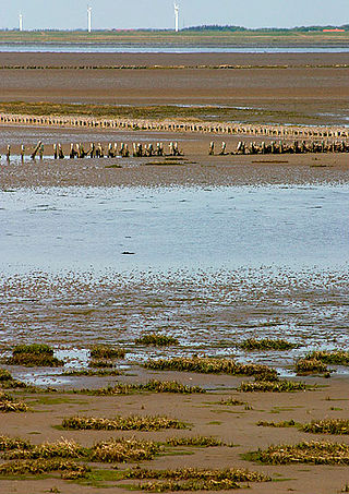
Wadden Sea National Park was designated a Danish national park on 17 January 2008, effective 2010. The Wadden Sea National Park is - except Greenland by far the largest of Denmark's national parks and covers the Danish part of the Wadden Sea from Ho Bugt to the German border, and includes the islands of Fanø, Mandø and Rømø, as well as Skallingen, the Varde Å valley, and many of the marshlands of Tjæreborgmarsken, Ribemarsken, Margrethekogen and De Ydre Diger in Tøndermarsken.
Lake Esrum is the largest lake in Denmark by water volume and the second-largest lake by surface area, after lake Arresø. It is situated in the central part of North Zealand, straddling the boundaries of the municipalities Hillerød, Fredensborg, Helsingør and Gribskov, some 40 kilometres north of Copenhagen.
Mols Bjerge National Park or Nationalpark Mols Bjerge is a Danish national park in the area known as Mols Bjerge in Syddjurs Municipality, Central Jutland, inaugurated on 29 August 2009. The protected area, measures 180 square kilometres (69 sq mi) in size. The Mols Hills, reaching a height of 137 metres (449 ft), are centrally located in the park, and take up 2,500 ha. "More than half of all wild Danish plant species" can be found at Mols Bjerge.
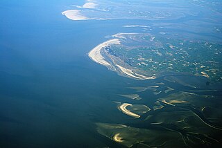
Thy National Park is a national park area in Thy, Denmark, opened to the public on 22 August 2008. It is located in Northwest Jutland, along the coast from Hanstholm to Agger Tange and it spans 55 km (34 mi) north to south and 5–12 km (3.1–7.5 mi) east to west. The total area of the national park is 244 km2.
Trehøje is a Danish vista point with a view of the sea to the east, south and west, located in the Mols Bjerge National Park on the peninsula Djursland between Denmark and Sweden. Three large bronze-age barrows close to each other 127 meters above the sea, have given their name to the place, which contains a group of 22 barrows. "Trehøje" meaning three mounds, is one of four major vista points in the hills of Mols, each with a barrow on top. The others are Ellemandsbjerg, Stabelhøje and Agri Baunehøj.
Stabelhøje or Stabel Høje are two Bronze Age Mounds 135 meters and 133 meters above sea level by the village Agri in Mols Bjerge on the peninsula Djursland in Denmark at the entrance to The Baltic Sea in Northern Europe. The burial mounds date back to the early Bronze Ages 1800–1000 years B.C. These hills are some of the more known view points in Mols Bjerge National Park. Other view points in the area are Agri Baunehøj, Trehøje, Ellemandsbjerg and Jernhatten.
Kongernes Nordsjælland is a national park in the northern region of the island of Zealand, Denmark. It opened in 2018.
Kalø Vig is a cove in the north end of the Bay of Aarhus, Denmark. It stretches in a semicircle from Skæring in the North West to Kalø Castle below Rønde in the North to the peninsula Skødshoved in the East. The area around Kalø Castle became a nature preserve in 1939 and is now a part of Mols Bjerge National Park. Sight lines over the cove from Hjelmager south of Løgten are subject to conservation and preservation rules.
Karlsladen is an old barn from 1727 that was transformed into a visitors centre for Mols Bjerge National Park in 2013. The thatched and timbered building covers 1,000 square meters. Access to the visitors centre is free, and it is open 7 days a week all year. Before restoration the barn was a dilapidated farm building as part of the now publicly owned Kalø Estate.
Agri Bavnehøj is a Danish hill and vista point with a bronze age burial mound, located 137 meters above sea level. It is close to the village of Agri, in Mols Bjerge National Park on the southern part of the Djursland peninsula, 40 kilometres (25 mi) northeast of Denmark’s second largest city, Aarhus. The mound was built 1800 – 1000 years BC. Agri Bavnehøj is the least known of four vista points and burial mounds on southern Djursland, despite being the highest. The others are Stabelhøje, Trehøje and Ellemandsbjerg.
Agger Tange is a peninsula located between the Limfjord and the North Sea. Agger Tange protrudes from the North Jutlandic Island, immediately south of the village Agger in Thy.
This page is based on this Wikipedia article Text is available under the CC BY-SA 4.0 license; additional terms may apply. Images, videos and audio are available under their respective licenses.