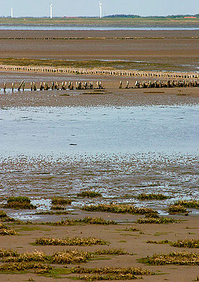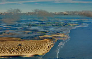
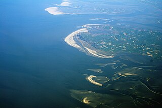
The Wadden Sea is an intertidal zone in the southeastern part of the North Sea. It lies between the coast of northwestern continental Europe and the range of low-lying Frisian Islands, forming a shallow body of water with tidal flats and wetlands. It has a high biological diversity and is an important area for both breeding and migrating birds. In 2009, the Dutch and German parts of the Wadden Sea were inscribed on UNESCO's World Heritage List and the Danish part was added in June 2014.

Ouse Washes is a linear 2,513.6-hectare (6,211-acre) biological Site of Special Scientific Interest stretching from near St Ives in Cambridgeshire to Downham Market in Norfolk, England. It is also a Ramsar internationally important wetland site, a Special Protection Area for birds, a Special Area of Conservation and a Nature Conservation Review site, Grade I. An area of 186 hectares between March and Ely is managed by the Wildlife Trust for Bedfordshire, Cambridgeshire and Northamptonshire and another area near Chatteris is managed by the Royal Society for the Protection of Birds. The Wildfowl & Wetlands Trust manages another area near Welney.

The Wadden Sea National Parks in Denmark, Germany and the Netherlands are located along the German Bight of the North Sea. In Germany and Denmark they also mark the area of the UNESCO World Heritage Site of the Wadden Sea. Divided from each other by administrative borders, they form a single ecological entity. The purpose of the national parks is the protection of the Wadden Sea ecoregion.
The Schleswig-Holstein Wadden Sea National Park is a national park in the Schleswig-Holstein area of the German Wadden Sea. It was founded by the Parliament of Schleswig-Holstein on 1 October 1985 by the National Park Act of 22 July 1985 and expanded significantly in 1999. Together with the Lower Saxon Wadden Sea National Park, the Hamburg Wadden Sea National Park and those parts of Elbe estuary which are not nature reserves, it forms the German part of the Wadden Sea.
The Hamburg Wadden Sea National Park is the smallest of the three German Wadden Sea National Parks which protect the single ecological entity of the Wadden Sea reaching from Den Helder to Esbjerg.

A transboundary protected area (TBPA) is an ecological protected area that spans boundaries of more than one country or sub-national entity. Such areas are also known as transfrontier conservation areas (TFCAs) or peace parks.

Western Port, commonly but unofficially known as Western Port Bay, is a large tidal bay in southern Victoria, Australia, opening into Bass Strait. It is the second largest bay in the state. Geographically, it is dominated by two large islands; French Island and Phillip Island. At the time it was renamed, its position was west of other known ports and bays, but Western Port has become something of a misnomer as it lies just to the east of the larger Port Phillip and the city of Melbourne. It is visited by Australian fur seals, whales and dolphins, as well as many migratory waders and seabirds. It is listed under the Ramsar Convention as a wetland of international significance.

The Sundarbans National Park is a national park in West Bengal, India, and core part of tiger reserve and biosphere reserve. It is part of the Sundarbans on the Ganges Delta and adjacent to the Sundarban Reserve Forest in Bangladesh. It is located to south-west of Bangladesh. The delta is densely covered by mangrove forests, and is one of the largest reserves for the Bengal tiger. It is also home to a variety of bird, reptile and invertebrate species, including the salt-water crocodile. The present Sundarban National Park was declared as the core area of Sundarban Tiger Reserve in 1973 and a wildlife sanctuary in 1977. On 4 May 1984 it was declared a national park. It is a UNESCO World Heritage Site inscribed in 1987, and it has been designated as a Ramsar site since 2019. It is considered as a World Network of Biosphere Reserve from 1989.
Keoladeo National Park, or Keoladeo Ghana National Park, is a national park in Rajasthan, India. The national park hosts thousands of native, resident and migratory birds, especially during the winter season, when many different species fly to the Indian subcontinent to escape winter's wrath further north in Eurasia. At least 400 avian species have been noted or observed in the national park.
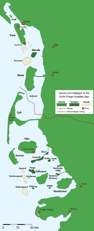
The Halligen or the halliger are small islands without protective dikes. They are variously pluralized in English as the Halligen, Halligs, Hallig islands, or Halligen islands. There are ten German halligen in the North Frisian Islands on Schleswig-Holstein's Wadden Sea–North Sea coast in the district of Nordfriesland and one remaining hallig at the west coast of Denmark (Langli).

Mandø or Manø is one of the Danish Wadden Sea islands off the southwest coast of Jutland, Denmark in the Wadden Sea, part of the North Sea. The island covers an area of 7.63 square kilometres and had between 27-31 inhabitants in January 2022. The island is part of Esbjerg Municipality and is situated approximately 12 kilometres southwest of the ancient town of Ribe.

Endelave is a Danish island in the Kattegat, north of Odense, off the coast of Funen, and west of Samsø. The island covers an area of 13.2 km2 (5.1 sq mi) and has 185 inhabitants.

Spittal Pond Nature Reserve is the largest wildlife sanctuary in Bermuda, located close to the Atlantic coast of Smith's Parish. Surrounding the third largest pond in Bermuda, Spittal Pond, it covers an area of 60 acres (24 ha). It is one of 13 parks or reserves managed by the Bermuda Department of Conservation Services which protects and conserves environmentally critical areas and habitats. The pond reserve, a wetland site, is one of the seven Ramsar Sites in Bermuda, which was approved on 10 May 1999 for the criteria of its unique characteristics such as its lagoon which is permanently brackish, ecology featuring wet grassland and mangrove forests, seasonal shorebirds, other ver run waterbirds and European eels. It is also home to many types of species mostly including birds.
Lauwersmeer National Park is a national park in the provinces of Friesland and Groningen in the Netherlands. It consists of the southern and eastern parts of the Lauwersmeer. As part of the Dutch Wadden Sea Conservation Area, it was inscribed on the UNESCO World Heritage List for its outstanding biodiversity and its large, relatively pristine intertidal ecosystem.
Varde is a Danish city in southwestern Jutland and is the primary city in the municipality of Varde, in Region of Southern Denmark. In 2015 municipality changed its motto to "We in nature" to emphasize its rural atmosphere. The town has an old market environment and is located by Varde stream/river and is a short distance away from the beaches by the North Sea. These features make it a tourist destination. The age of Varde is not known precisely, but it is mentioned in written sources from 1107 A.D. and is therefore thought have been founded sometime in the early Middle Ages.

The Lower Saxon Wadden Sea National Park was established in 1986 and embraces the East Frisian Islands, mudflats and salt marshes between the Bay of Dollart on the border with the Netherlands in the west and Cuxhaven as far as the Outer Elbe shipping channel in the east. The national park has an area of about 345,800 hectares (1,335 sq mi). The National Park organisation is located in Wilhelmshaven. In June 2009, the National Park became a UNESCO World Heritage Site along with the Schleswig-Holstein Wadden Sea and the Dutch Wadden Sea, highlighting its unique intertidal ecosystem and high biodiversity.

is an uninhabited island in the Meldorf Bay, about 14 kilometres off the North Sea coast of Dithmarschen in north Germany – about 12 kilometres from the Trischendamm embankment. The island belongs to the municipality of Friedrichskoog and is only occupied from March to October by a bird warden from the Nature and Biodiversity Conservation Union or NABU. Otherwise it is out-of-bounds. Trischen originated about 400 years ago and moves about 3 m per month towards Büsum on the mainland.

Südfall is a small island in the Wadden Sea off the west coast of Schleswig-Holstein, Germany, one of the ten German Hallig islands. It has a permanent population of two people. It covers an area of 0.56 square kilometres (0.22 sq mi) and is administratively part of Pellworm Municipality.

The Waddensea of Hamburg between Elbe and Weser is a German Biosphere reserve. It was added in 1992 by the UNESCO in their "man and biosphere" (MAB).
Ho Bay is a Danish bay with an approximate area of 50 square kilometres (19 sq mi). It constitutes the northern end of the Wadden Sea, and lies between Skallingen in the southwest, Ho in the west, Oksbøl to the north and Hjerting to the east. At the northeastern end, Varde Å has its outlet through Tarp and Billum Enge, north of Marbæk Plantage.