Wadden Sea National Parks

Last updated
Satellite view of the German Bight and the Wadden Sea. German Bight.jpg
Satellite view of the German Bight and the Wadden Sea.

The Wadden Sea National Parks in Denmark, Germany and the Netherlands are located along the German Bight of the North Sea. In Germany and Denmark they also mark the area of the UNESCO World Heritage Site of the Wadden Sea. Divided from each other by administrative borders, they form a single ecological entity. The purpose of the national parks is the protection of the Wadden Sea ecoregion.

Denmark Constitutional monarchy in Europe

Denmark, officially the Kingdom of Denmark, is a sovereign state in Northern Europe. Denmark proper consists of a peninsula, Jutland, and an archipelago of 443 named islands, with the largest being Zealand, Funen and the North Jutlandic Island. The islands are characterised by flat, arable land and sandy coasts, low elevation and a temperate climate. The southernmost of the Scandinavian nations, Denmark lies southwest of Sweden and south of Norway, and is bordered to the south by Germany. The Kingdom of Denmark also comprises two autonomous constituent countries in the North Atlantic Ocean: the Faroe Islands and Greenland. Denmark has a total area of 42,924 km2 (16,573 sq mi), land area of 42,394 km2 (16,368 sq mi), and the total area including Greenland and the Faroe Islands is 2,210,579 km2 (853,509 sq mi), and a population of 5.8 million.

Germany Federal parliamentary republic in central-western Europe

Germany, officially the Federal Republic of Germany, is a country in Central and Western Europe, lying between the Baltic and North Seas to the north, and the Alps, Lake Constance and the High Rhine to the south. It borders Denmark to the north, Poland and the Czech Republic to the east, Austria and Switzerland to the south, France to the southwest, and Luxembourg, Belgium and the Netherlands to the west.

Netherlands Constituent country of the Kingdom of the Netherlands in Europe

The Netherlands is a country located mainly in Northwestern Europe. The European portion of the Netherlands consists of twelve separate provinces that border Germany to the east, Belgium to the south, and the North Sea to the northwest, with maritime borders in the North Sea with Belgium, Germany and the United Kingdom. Together with three island territories in the Caribbean Sea—Bonaire, Sint Eustatius and Saba—it forms a constituent country of the Kingdom of the Netherlands. The official language is Dutch, but a secondary official language in the province of Friesland is West Frisian.

Contents

Denmark

Wadden Sea National Park, Denmark National park in Denmark

Wadden Sea National Park was designated a Danish national park on 17 January 2008, effective 2010. Since June 2014 it has constituted the Danish part of the UNESCO's Wadden Sea World Heritage Site. Prince Joachim of Denmark is Patron of the Wadden Sea Centre.

Blåvandshuk

Blåvandshuk is a headland on the North Sea coast of Jutland northwest of Esbjerg, and is the westernmost point of metropolitan Denmark. The Blåvand Lighthouse is the westernmost located building in Denmark.

Germany

Schleswig-Holstein Wadden Sea National Park national park of Germany

The Schleswig-Holstein Wadden Sea National Park is a national park in the Schleswig-Holstein area of the German Wadden Sea. It was founded by the Parliament of Schleswig-Holstein on 1 October 1985 by the National Park Act of 22 July 1985 and expanded significantly in 1999. Together with the Lower Saxon Wadden Sea National Park, the Hamburg Wadden Sea National Park and those parts of Elbe estuary which are not nature reserves, it forms the German part of the Wadden Sea.

North Frisian Islands group of islands in the Wadden Sea

The North Frisian Islands are the Frisian Islands off the coast of North Frisia.

Hamburg Wadden Sea National Park national park in Germany

The Hamburg Wadden Sea National Park is the smallest of the three German Wadden Sea National Parks which protect the single ecological entity of the Waddensea of Hamburg reaching from Den Helder to Esbjerg.

Netherlands

Lauwersmeer National Park

Lauwersmeer National Park is a national park in the provinces of Friesland and Groningen in the Netherlands. It consists of the southern and eastern parts of the Lauwersmeer.

Schiermonnikoog National Park

Schiermonnikoog National Park is a national park in the Dutch province of Friesland. It was founded in 1989. It covers about 72 km2 (28 sq mi), the majority of the island Schiermonnikoog.

Dunes of Texel National Park

Dunes of Texel National Park is a national park located on the North-Holland island of Texel in the Netherlands. All dune systems on the western side of the island and the large coastal plains on both the northern and southern points of the island are part of the park. The park covers approximately 43 km2 (17 sq mi) and attained national park status in 2002. The visitor center is located in the natural history museum Ecomare.

Greetsiel Ortsteil of Krummhörn in Lower Saxony, Germany

Greetsiel is a small port on the bight of Leybucht in western East Frisia, Germany that was first documented in letters from the year 1388. Since 1972, Greetsiel has been part of the municipality of Krummhörn, which has its administrative seat in Pewsum. The nearest railway station is at Emden, about 15–20 kilometres (9.3–12.4 mi) away, and the two towns are linked by a bus service.

Shoal A natural landform that rises from the bed of a body of water to near the surface and is covered by unconsolidated material

In oceanography, geomorphology, and earth sciences, a shoal is a natural submerged ridge, bank, or bar that consists of, or is covered by, sand or other unconsolidated material, and rises from the bed of a body of water to near the surface. Often it refers to those submerged ridges, banks, or bars that rise near enough to the surface of a body of water as to constitute a danger to navigation. Shoals are also known as sandbanks, sandbars, or gravelbars. Two or more shoals that are either separated by shared troughs or interconnected by past or present sedimentary and hydrographic processes are referred to as a shoal complex.

Lower Saxon Wadden Sea National Park

The Lower Saxon Wadden Sea National Park was established in 1986 and embraces the East Frisian Islands, mudflats and salt marshes between the Bay of Dollart on the border with the Netherlands in the west and Cuxhaven as far as the Outer Elbe shipping channel in the east. The national park has an area of about 345,800 hectares (1,335 sq mi). The National Park organisation is located in Wilhelmshaven. Since June 2009 the Lower Saxon Wadden Sea National Park has become a UNESCO World Heritage Site along with the Schleswig-Holstein Wadden Sea and the Dutch Wadden Sea.

See also

Coordinates: 53°54′08″N8°17′25″E / 53.902097°N 8.290216°E / 53.902097; 8.290216

Geographic coordinate system Coordinate system

A geographic coordinate system is a coordinate system that enables every location on Earth to be specified by a set of numbers, letters or symbols. The coordinates are often chosen such that one of the numbers represents a vertical position and two or three of the numbers represent a horizontal position; alternatively, a geographic position may be expressed in a combined three-dimensional Cartesian vector. A common choice of coordinates is latitude, longitude and elevation. To specify a location on a plane requires a map projection.

Related Research Articles

Nordfriesland (district) District in Schleswig-Holstein, Germany

Nordfriesland is the northernmost district of Germany, part of the state of Schleswig-Holstein. It includes almost all of traditional North Frisia along with adjacent areas to the east and south and is bound by the districts of Schleswig-Flensburg and Dithmarschen, the North Sea and the Danish county of South Jutland. The district is called Kreis Nordfriesland in German, Kreis Noordfreesland in Low German, Kris Nordfraschlönj in Mooring North Frisian, Kreis Nuurdfresklun in Fering North Frisian and Nordfrislands amt in Danish.

Frisia coastal region on the North Sea in the Netherlands and Germany formerly a historic region with its own language

Frisia is a coastal region along the southeastern corner of the North Sea in what today is mostly a large part of the Netherlands, including modern Friesland and smaller parts of northern Germany. Frisia is the traditional homeland of the Frisians, Germanic people who speak Frisian languages, which together with Anglic languages form the Anglo-Frisian language group.

East Frisian Islands chain of German islands in the North Sea

The East Frisian Islands are a chain of islands in the North Sea, off the coast of East Frisia in Lower Saxony, Germany. The islands extend for some 90 kilometres (56 mi) from west to east between the mouths of the Ems and Jade / Weser rivers and lie about 3.5 to 10 km offshore. Between the islands and the mainland are extensive mudflats, known locally as Watten, which form part of the Wadden Sea. In front of the islands are Germany's territorial waters, which occupy a much larger area than the islands themselves. The islands, the surrounding mudflats and the territorial waters form a close ecological relationship. The island group makes up about 5% of the Lower Saxony Wadden Sea National Park.

Amrum German island

Amrumpronunciation  is one of the North Frisian Islands on the German North Sea coast, south of Sylt and west of Föhr. It is part of the Nordfriesland district in the federal state of Schleswig-Holstein and has appromixately 2,300 inhabitants.

West Frisian Islands chain of islands in the North Sea

The West Frisian Islands are a chain of islands in the North Sea off the Dutch coast, along the edge of the Wadden Sea. They continue further east as the German East Frisian Islands and are part of the Frisian Islands.

Frisian Islands archipelago in the Wadden Sea

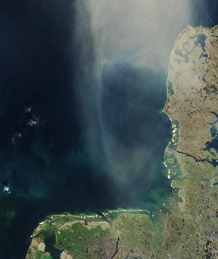
The Frisian Islands, also known as the Wadden Islands or the Wadden Sea Islands, form an archipelago at the eastern edge of the North Sea in northwestern Europe, stretching from the northwest of the Netherlands through Germany to the west of Denmark. The islands shield the mudflat region of the Wadden Sea from the North Sea.

Heligoland Bight

The Heligoland Bight, also known as Helgoland Bight, is a bay which forms the southern part of the German Bight, itself a bay of the North Sea, located at the mouth of the Elbe river. The Heligoland Bight extends from the mouth of the River Elbe to the islands of Heligoland and lies between the East Frisian island of Wangerooge and the North Frisian peninsula of Eiderstedt.

Halligen type of small island in the Wadden Sea without protective dikes

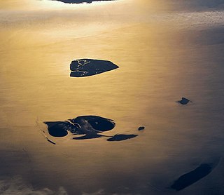
The Halligen (German) or the halliger are small islands without protective dikes. There are ten German halligen in the North Frisian Islands on Schleswig-Holstein's Wadden Sea-North Sea coast in the district of Nordfriesland and one hallig at the west coast of Denmark.

Mudflat hiking

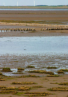
Mudflat hiking is a recreation enjoyed by Dutch, Germans, Danes, and others in the Netherlands, northwest Germany and in Denmark. Mudflat hikers are people who, with the aid of a tide table, use a period of low water to walk and wade on the watershed of the mudflats, especially from the Frisian mainland coast to the Frisian islands.

Hooge, Germany Place in Schleswig-Holstein, Germany

Hooge is a municipality in the district of Nordfriesland, in Schleswig-Holstein, Germany.

North Frisian Barrier Island

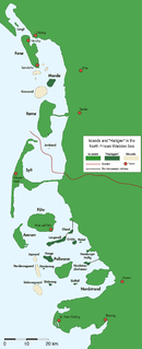
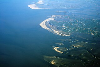
North Frisian Barrier Island is the collective term for three barrier islands due west of the German Halligen in the North Frisian Islands archipelago. The shoals act as natural breakwater for the Halligen and other islands closer to land. Uninhabited, they remain one of the few areas in the Wadden Sea that are unaffected by direct human activity.

Langeneß Place in Schleswig-Holstein, Germany

Langeneß  is a municipality in the district of Nordfriesland, in Schleswig-Holstein, Germany. It consists of the halligen (islands) Langeneß and Oland. Before the flood of 1634 the two islands were directly attached.

Nordstrandischmoor A hallig in the Wadden Sea - a tidal island

Nordstrandischmoor is a Hallig off the North Frisian coast in Germany and lies within the Schleswig-Holstein Wadden Sea National Park.

Unterelbe river in Germany

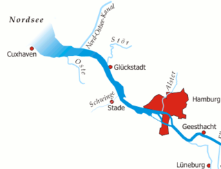
The Unterelbe or, in English usually the Lower Elbe, refers to the lower reaches of the river Elbe in Germany influenced by the tides.

Südfall is a small island in the Wadden Sea off the west coast of Schleswig-Holstein, Germany, one of the ten German Hallig islands. It has a permanent population of two people. It covers an area of 0.56 square kilometres (0.22 sq mi) and is administratively part of Pellworm Municipality.