List of parks and open spaces in Cheshire

Last updated

This is a list of parks and open spaces in the ceremonial county of Cheshire . It includes urban parks, country parks, islands, woodlands, commons, lakes, walking trails, local nature reserves and other green spaces that are open to the public. Small neighbourhood parks and pocket parks are not included.

Contents

Parks and open spaces in Cheshire

NameImageLocationTypeNotesRefs
Astbury Mere Country Park Astbury Mere.jpg West Heath, Congleton Country park, lakeCountry park surrounding a fishing and boating lake, with grassland and woodland, on the site of a former sand quarry [1]
Bickerton Hill Maiden Castle summit Bickerton.jpg Bickerton HillsTwo hills, lowland heath and woodland; includes an Iron Age hill fort, Maiden Castle. Falls within an Area of Special County Value and parts are Sites of Special Scientific Interest; much of the southern hill is managed by the National Trust [2]
Birchwood Forest Park Birchwood Forest Park - geograph.org.uk - 29274.jpg Birchwood Urban parkGrassland, woodland, sports pitches [3]
Burton Mere Wetlands InnerMarshFarm.jpg Dee Estuary RSPB reserveManaged by the RSPB as a reserve for birdlife
The Carrs Park The Carrs, Wilmslow. - geograph.org.uk - 84100.jpg Wilmslow Urban parkAlong the banks of the River Bollin
Castle Park Frodsham - Castle Park House (geograph 3116662).jpg Frodsham Urban parkIn the grounds of Castle Park House
Countess of Chester Country Park Mother and Child (geograph 4413163).jpg Chester Country parkAdjacent to the Countess of Chester Hospital [4]
Delamere Forest More Autumn Colour, Delamere Forest - geograph.org.uk - 73480.jpg Delamere Woodlands and lakesOpen forest around Blakemere Moss (lake) [5]
Dutton Locks Dutton Locks - geograph.org.uk - 1531904.jpg Dutton Historic canal locks Green spaces along the towpath of the River Weaver and at the canal locks
Grappenhall Heys Walled Garden Grappenhall Heys Walled Garden - geograph.org.uk - 1728569.jpg Warrington Walled gardenPonds, garden and glasshouses
Grosvenor Park Grosvenor Park Arch.jpg Chester Urban parkVictorian park including Billy Hobby's Well, three medieval arches, a café, miniature railway and a rockery [6]
Helsby Hill Helsby, The Hill in the Snow - geograph.org.uk - 208875.jpg Helsby HillManaged by the National Trust, overlooking the town
Lindow Common Black Lake, Lindow Common. - geograph.org.uk - 92159.jpg Wilmslow HeathlandLocal nature reserve and SSSI, managed by Cheshire East Council
Lindow Moss Peat workings - geograph.org.uk - 61802.jpg Wilmslow Peat bogPartly owned by Cheshire Wildlife Trust
Lymm Dam Lymm Dam.jpg Lymm LakeLake, woodland and open spaces
Macclesfield Forest Macclesfield Forest+Trentabank.jpg Macclesfield Forest and Wildboarclough WoodlandWoodland, plantation and two reservoirs. Parts are a nature reserve and a Site of Biological Importance, and two-thirds falls within the Peak District [7]
Marbury Country Park Marbury park.jpg Northwich Country parkWoodland and open spaces
Moore Nature Reserve Moore nature reserve 1.jpg Moore Local nature reserveLakes for birdwatching and walking routes [8]
Mount Manisty Manchester Ship Canal by Mount Manisty 3668914.jpg Ellesmere Port MoundUninhabited area
Ness Botanic Gardens Ness Botanic Gardens, Wirral - geograph.org.uk - 290775.jpg Ness Botanic gardensSpecimen trees and flowers [9]
Northwich Woodlands Carden's Ferry Bridge.jpg Northwich VariousA number of different open spaces
Orford Park Warrington Urban parkFormer grounds of Orford Hall, with pond and sports pitches [10]
Paddington Meadows River Mersey at Paddington Meadows, Warrington.jpg Warrington Local nature reserveAlong the banks of the River Mersey [11]
Phoenix Park Phoenix Park, Runcorn - DSC06736.JPG Runcorn Urban parkWoodland, canal and open spaces [12]
Queens Park Queens park crewe towards pavilion.jpg Crewe Urban parkGrade II* listed
Risley Moss Risley moss nature reserve.jpg Warrington Peat bogNature reserve and bird watching
Rivacre Valley Rivacre Valley Country Park (2).JPG Ellesmere Port Local nature reserveWoodland and meadow [13]
Rixton Clay Pits Rixton Clay Pits - geograph.org.uk - 1528337.jpg Hollins Green PoolsFormer clay pits, with ponds, grassland, scrub, woodland; part is an SSSI and local nature reserve [14]
Sankey Valley Park Sankey Valley Park May 2007.JPG Warrington CanalLinear park, following Sankey Brook and Sankey Canal [15]
Shakerley Mere South End of Shakerley Mere - geograph.org.uk - 83915.jpg Allostock LakeFormer gravel pit with circular walk
Sound Heath Sound Heath SSSI.jpg Sound Heathland, pondsCommon with heathland, woodland and ponds; SSSI and local nature reserve [16]
Spike Island Spike Island.jpg Widnes ParkOpen parkland with industrial archaeological history and a canal [17]
Stanlow Island River Gogg looking North from Manchester Ship Canal - geograph.org.uk - 1210099.jpg Ellesmere Port IslandBecame an island during construction of the Manchester Ship Canal. Occupied until the 1990s when the locals left due to isolation and the hazards of living near the refinery. Remains of Stanlow Abbey on site.
Tatton Park TattonMere.jpg Knutsford ParklandThe parkland associated with Tatton Hall, freely accessible, entry to the house, gardens or car park requires a fee
Tegg's Nose Country Park Teggs Nose quarry.jpg near Macclesfield Country parkHill, meadow, moorland, woodland, reservoirs; display of historical quarrying equipment [18]
Town Park Town Park in Runcorn, Cheshire, England.jpg Runcorn Urban parkGreen space with dry ski slope
Victoria Park Victoria Park, Widnes (8).JPG Widnes Urban parkMain urban park with listed war memorial pillar [19]
Victoria Park River Mersey at Latchford - geograph.org.uk - 713601.jpg Warrington Urban parkOn the banks of the River Mersey with athletics stadium
Walton Hall Walton Hall, Cheshire.jpg Warrington Park and formal gardensWith zoo, events and leisure activities
Walton Lea Walled Garden The Gardeners' chronicle - a weekly illustrated journal of horticulture and allied subjects (1897) (14779649191).jpg Warrington Walled gardenManaged by a charity
Whitby Park Whitby Park, Ellesmere Port (8).JPG Ellesmere Port Urban parkPremier park in the town [20]
Wigg Island A remnant of the Runcorn and Latchford canal on Wigg Island.jpg Runcorn Park and nature reserveWalking, nature and bird hides
Whitegate Way Whitegate Way, Grange Lane - geograph.org.uk - 192803.jpg Whitegate FootpathWalking and cycling path on disused railway line
Woolston Park Warrington ParkGrassland, playing fields, brook
Wybunbury Moss Wybunbury Moss.jpg Wybunbury Peat bogNational Nature Reserve with permitted path access; owned and managed by Natural England

See also

Related Research Articles

<span class="mw-page-title-main">Cheshire</span> County of England

Cheshire is a ceremonial county in North West England. It is bordered by Merseyside to the north-west, Greater Manchester to the north-east, Derbyshire to the east, Staffordshire to the south-east, and Shropshire to the south; to the west it is bordered by the Welsh counties of Flintshire and Wrexham, and has a short coastline on the Dee Estuary. Warrington is the largest settlement, and the city of Chester is the county town.

<span class="mw-page-title-main">Frodsham</span> Town and civil parish in England

Frodsham is a market town, civil parish, and electoral ward in the unitary authority of Cheshire West and Chester and the ceremonial county of Cheshire, England. Its population in 2021 was 9,300. It is 16 miles (26 km) south of Liverpool and 28 miles (45 km) southwest of Manchester. The River Weaver runs to its northeast and on the west it overlooks the estuary of the River Mersey. The A56 road and the Chester–Manchester railway line pass through the town, and the M56 motorway passes to the northwest.

<span class="mw-page-title-main">Runcorn</span> Town in England

Runcorn is an industrial town and cargo port in the Borough of Halton, Cheshire, England. Its population in 2021 was 62,100. Runcorn is on the southern bank of the River Mersey, where the estuary narrows to form the Runcorn Gap.

<span class="mw-page-title-main">Ellesmere Port</span> Town in Cheshire, England

Ellesmere Port is a port town in the Cheshire West and Chester borough in Cheshire, England. Ellesmere Port is on the south eastern edge of the Wirral Peninsula, 6 miles (9.7 km) north of Chester, on the bank of the Manchester Ship Canal. The town had a population of 61,090 in the 2011 census. Ellesmere Port also forms part of the wider Birkenhead urban area, which had a population of 325,264 in 2011.

<span class="mw-page-title-main">Ellesmere Port and Neston</span>

Ellesmere Port and Neston was, from 1974 to 2009, a local government district with borough status in Cheshire, England. It covered the southern part of the Wirral Peninsula, namely that part which is not included in the Metropolitan Borough of Wirral.

<span class="mw-page-title-main">Risley Moss</span> Area of peat bog in Warrington, England

Risley Moss is an area of peat bog situated near Birchwood in Warrington, England. It is a country park, Site of Special Scientific Interest and a Local Nature Reserve. It covers an area of 210.5 acres (85.2 ha) and is one of the last remaining fragments of the raised bogs that once covered large areas of South Lancashire and North Cheshire.

<span class="mw-page-title-main">Civil parishes in Cheshire</span>

A civil parish is a country subdivision, forming the lowest unit of local government in England. There are 333 civil parishes in the ceremonial county of Cheshire, most of the county being parished. Cheshire East unitary authority is entirely parished. At the 2001 census, there were 565,259 people living in 332 parishes, accounting for 57.5 per cent of the county's population.

<span class="mw-page-title-main">Ellesmere Port and Neston (UK Parliament constituency)</span> UK Parliament constituency since 1983

Ellesmere Port and Neston is a constituency represented in the House of Commons of the UK Parliament since 2015 by Justin Madders of the Labour Party.

<span class="mw-page-title-main">Weaver Vale (UK Parliament constituency)</span> Parliamentary constituency in the United Kingdom, 1997 onwards

Weaver Vale is a constituency in Cheshire represented in the House of Commons of the UK Parliament since 2017 by Mike Amesbury, a member of the Labour Party.

<span class="mw-page-title-main">Elton, Cheshire</span> Human settlement in England

Elton is a village and civil parish in Cheshire West and Chester, Cheshire, England, 13 km (8.1 mi) northeast of Chester, between Helsby and Ellesmere Port, near the River Mersey. Its proximity to the Mersey and the Manchester Ship Canal have contributed to its industrial character. The village is on the north-western edge of the Cheshire Plain, 2.5 km (1.6 mi) from Stanlow Refinery.

<span class="mw-page-title-main">Helsby railway station</span> Railway station in Cheshire, England

Helsby railway station serves the village of Helsby in Cheshire, England. It is recorded in the National Heritage List for England as a Grade II listed building.

<span class="mw-page-title-main">Cheshire County Council</span> Former local authority in England

Cheshire County Council was the county council of Cheshire. Founded on 1 April 1889, it was officially dissolved on 31 March 2009, when it and its districts were superseded by two unitary authorities; Cheshire West and Chester and Cheshire East.

<span class="mw-page-title-main">Chester–Warrington line</span>

The Chester–Warrington line is a railway line running between Chester and Warrington Bank Quay in North West England.

<span class="mw-page-title-main">Cheshire West and Chester</span> Borough in England

Cheshire West and Chester is a unitary authority area with borough status in Cheshire, England. It was established on 1 April 2009 as part of the 2009 local government changes, by virtue of an order under the Local Government and Public Involvement in Health Act 2007. It superseded the boroughs of Ellesmere Port and Neston, Vale Royal and the City of Chester; its council assumed the functions and responsibilities of the former Cheshire County Council within its area. The remainder of ceremonial Cheshire is composed of Cheshire East, Halton and Warrington. Cheshire West and Chester has three key urban areas: Chester, Ellesmere Port and Northwich/Winsford.

<span class="mw-page-title-main">Borough of Warrington</span> Unitary authority area in Cheshire, England

The Borough of Warrington is a unitary authority area with borough status in the ceremonial county of Cheshire, England. The borough is centred around the town of Warrington, and extends out into outlying villages of Lymm and Great Sankey and the town of Birchwood.

<span class="mw-page-title-main">Warrington</span> Town in Cheshire, England

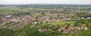
Warrington is an industrial town in the borough of the same name in Cheshire, England. The town sits on the banks of the River Mersey and until 1974, was part of Lancashire. It is 19 miles (31 km) east of Liverpool, and 18 miles (29 km) west of Manchester.

The ceremonial county of Cheshire, which comprises the unitary authorities of Cheshire East, Cheshire West and Chester, Halton and Warrington, has returned 11 MPs to the UK Parliament since 1997.

References

  1. Activities and information About Astbury Mere Country Park, Cheshire East, retrieved 13 May 2019
  2. "Explore the diverse landscape of Bickerton Hill". National Trust. Retrieved 13 May 2019.
  3. "Birchwood Forest Park". Warrington Borough Council. 2019. Retrieved 14 May 2019.
  4. "Countess of Chester Country Park".
  5. "Delamere Forest".
  6. Historic England, "Grosvenor Park, Chester (1001577)", National Heritage List for England , retrieved 2 September 2013
  7. "Welcome to Macclesfield Forest" (PDF). Peak District National Park. 2007. Archived from the original (PDF) on 17 August 2007. Retrieved 13 May 2019.
  8. "Moore Nature Reserve".
  9. "Ness Botanic Gardens". University of Liverpool. Retrieved 12 May 2019.
  10. "Local amenities - Orford Park". Warrington Borough Council. Retrieved 14 May 2019.
  11. "Parks and recreation grounds - Paddington Meadows". Warrington Borough Council. Archived from the original on 14 May 2019. Retrieved 21 February 2022.
  12. "Parks & Allotments". www3.halton.gov.uk.
  13. "Rivacre Valley - Your Ellesmere Port". Cheshire West and Cheshire Council. Retrieved 21 April 2021.
  14. "Rixton Claypits Local Nature Reserve". Warrington Borough Council. Archived from the original on 5 June 2013. Retrieved 7 October 2012.
  15. "Sankey Valley Park". Warrington Borough Council. Archived from the original on 13 December 2007. Retrieved 13 January 2008.
  16. "Sound Heath SSSI". Natural England. Retrieved 14 May 2019.
  17. "Spike Island | Visit Halton".
  18. "Country Parks: Tegg's Nose Walks". Cheshire County Council. Archived from the original on 27 November 2007. Retrieved 13 May 2019.
  19. "Parks, Allotments and Bowling Greens: Find Out More".
  20. "Whitby Park - Your Ellesmere Port". ellesmereport.yourwestcheshire.co.uk.