
This is a list of places in Guatemala .
This is a list of places in Guatemala .
Population data up to number 30 is based on the 2018 census.
Departmental Capital
National Capital and Departmental Capital


| Major lakes (lagos) in Guatemala | |||
|---|---|---|---|
| Lake | Location | Department (state administrative district) | |
| Amatitlán | 14.4500 -90.5667 (14°27'N ~ 90°34'W) | Guatemala | |
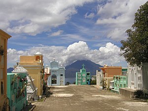
| Atitlán | 14.7000 -91.2000 (14°42'N ~ 91°12'W) | Sololá | |
| Ayarza, Laguna de | 14.4167 -90.1333 (14°25'N ~ 90°08'W) | Santa Rosa | |
| El Golfete | 15.7333 -88.8833 (15°44'N ~ 88°53'W) | Izabal | |
| Izabal | 15.5000 -89.1667 (15°30'N ~ 89°10'W) | Izabal | |
| Peten Itzá | 16.9833 -89.8333 (16°59'N ~ 89°50'W) | El Petén | |

Guatemala City, formally New Guatemala of Assumption and the Ancient, known locally as Guate, is the capital and largest city of Guatemala, and the most populous urban area in Central America. The city is located in the south-central part of the country, nestled in a mountain valley called Valle de la Ermita. The city is also the capital of the Guatemala Department.

Guatemala is mountainous, except for the south coastal area and the vast northern lowlands of Petén department. The country is located in Central America and bounded to the north and west by Mexico, to the east by Belize and by the Gulf of Honduras, to the east by Honduras, to the southeast by El Salvador, and to the south by the Pacific Ocean. Two mountain chains enter Guatemala from west to east, dividing the country into three major regions: the highlands, where the mountains are located; the Pacific coast, south of the mountains; and the limestone plateau of the Petén region, north of the mountains. These areas vary in climate, elevation, and landscape, providing dramatic contrasts between hot and humid tropical lowlands and highland peaks and valleys.

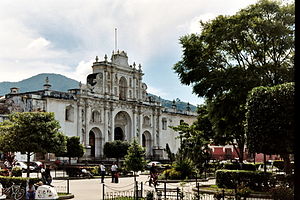
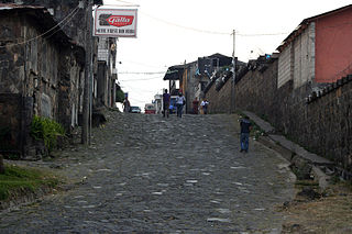
Antigua Guatemala, commonly known as Antigua or La Antigua, is a city in the central highlands of Guatemala. The city was the capital of the Captaincy General of Guatemala from 1543 through 1773, with much of its Baroque-influenced architecture and layout dating from that period. These characteristics had it designated as a UNESCO World Heritage Site in 1979. Antigua Guatemala serves as the capital of the homonymous municipality and the Sacatepéquez Department.

Sacatepéquez is one of the 22 departments of Guatemala. The name comes from Sacatepéquez, a city from November 21, 1542, until July 29, 1773, when it was destroyed by the 1773 Guatemalan Earthquake. Sacatepéquez means grasshill in the Nahuatl language. The capital of Sacatepéquez is Antigua Guatemala. Other important cities include Ciudad Vieja and San Lucas Sacatepéquez, which also hosts a marketplace and is a culinary attraction. The Chajoma were a group of indigenous people who were Kaqchikel speaking Indians identified Mixco Viejo as their capital, and spread throughout the Sacatepequez Department until their capital was moved to Ciudad Vieja, in Antigua.

Cuilapa, also known as Santa Rosa Cuilapa, is a town, with a population of 41,359, in Guatemala. It serves as the capital of the department of Santa Rosa and as the administrative seat for the surrounding municipality of Cuilapa.
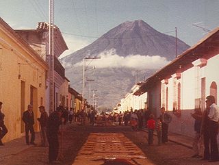
Volcán de Agua is an extinct stratovolcano located in the departments of Sacatepéquez and Escuintla in Guatemala. At 3,760 m (12,340 ft), Agua Volcano towers more than 3,500 m (11,500 ft) above the Pacific coastal plain to the south and 2,000 m (6,600 ft) above the Guatemalan Highlands to the north. It dominates the local landscape except when hidden by cloud cover. The volcano is within 5 to 10 km of the city of Antigua Guatemala and several other large towns situated on its northern apron. These towns have a combined population of nearly 100,000. It is within about 20 km (12 mi) of Escuintla to the south. Coffee is grown on the volcano's lower slopes.

Volcán de Fuego or Chi Q'aq' is an active stratovolcano in Guatemala, on the borders of Chimaltenango, Escuintla and Sacatepéquez departments.

Alotenango is a town and municipality in the Guatemalan department of Sacatepéquez. According to the 2018 census, the town has a population of 23,358. The municipality consists of four wards and is situated on the Escuintla road. Located in a valley, Alotenango is a Ladino coffee center, since the times of general Justo Rufino Barrios liberal regime (1873–1885).

Ciudad Vieja is a town and municipality in the Guatemalan department of Sacatepéquez. According to the 2018 census, the town has a population of 32,802 and the municipality a population of 33,405. Ciudad Vieja was the second site of Santiago de los Caballeros de Guatemala, the colonial capital of the country.

Santa Maria de Jesus is a town, with a population of 21,795, and a municipality in the department of Sacatepéquez about 10 km from the city of Antigua Guatemala. It is located under the slopes of Volcán de Agua. This town has a height of 2,070 meters above sea level. Its central square has a temple built in the seventeenth century with a carved entry arch. Spanish and Kaqchikel are spoken in this town.
Acatenango is a town and municipality in the Chimaltenango department of Guatemala. It is in this municipality that the Acatenango volcano is located. The town is in the valley of the Cocoyá River.
Yepocapa, also known as San Pedro Yepocapa, is a town with a population of 17,021, and a municipality in the Chimaltenango department of Guatemala. It is located at the base of Volcán de Fuego, which has destroyed the town several times, most recently on 15 October 1974.
San Lucas Tolimán is a municipality in the Sololá department of Guatemala. The town of 17,000 people sits on the southeastern shore of Lago de Atitlán. The population is 90–95% Highland Maya. There is a population of about the same size living in the surrounding villages.

Volcán Tajumulco is a large stratovolcano in the department of San Marcos in western Guatemala. It is the highest mountain in Central America at 4,203 metres (13,789 ft). It is part of the mountain range of the Sierra Madre de Chiapas, which begins in Mexico's southernmost state of Chiapas.

The volcano Tacaná is the second highest peak in Central America at 4,060 metres (13,320 ft), located in the Sierra Madre de Chiapas of northern Guatemala and southern Mexico. It is also known in Mexico as Volcán Tacina.
The following outline is provided as an overview of and topical guide to Guatemala:
The following is an alphabetical list of topics related to the Republic of Guatemala.

The 2018 Volcán de Fuego eruption was an eruption of Volcán de Fuego in Guatemala on Sunday 3 June 2018. The eruption produced a large ash plume fed by continuous explosions, pyroclastic flows, and lahars. Pyroclastic flows descended the Las Lajas ravine and overspilled its confines, causing the death of officially nearly 200 people. This was the deadliest eruption in Guatemala since the eruption of Volcán Santiaguito in 1902.
