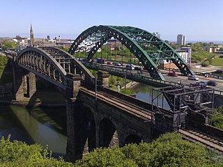
Sunderland is a port city in Tyne and Wear, North East England. It is located at the mouth of the River Wear on the North Sea, approximately 10 miles (16 km) south-east of Newcastle upon Tyne. The city has a population of 168,277, making it the second largest settlement in the North East after Newcastle. It is the administrative centre of the metropolitan borough of the same name.

Sunderland, commonly known as the City of Sunderland, is a metropolitan borough with city status in the metropolitan county of Tyne and Wear, England. It is named after its largest settlement, Sunderland, spanning a far larger area, including nearby towns including Washington, Hetton-le-Hole and Houghton-le-Spring, as well as the surrounding villages and hamlets. The district also forms a large majority of Wearside which includes Chester-le-Street in County Durham.
Following is a list of dates in the history of Sunderland, the ancient city in North East England. Facts and figures, important dates in Sunderland's history.

Seaburn is a seaside resort and northeastern suburb of Sunderland, North East England. The village of Whitburn borders the area to the north. To the west and south-west is Fulwell and to the south the coastal resort of Roker.

Roker is a tourist resort and affluent area of Sunderland, North East England, bounded on the south by the River Wear and Monkwearmouth, on the east by the North Sea, to the west by Fulwell and on the north by Seaburn. It is administered as part of the City of Sunderland and lies within historic County Durham.

The village of Penshaw, formerly known as Painshaw or Pensher, is an area of the metropolitan district of the City of Sunderland, in Tyne and Wear, England. Historically, Penshaw was located in County Durham.

Sunderland North was a borough constituency represented in the House of Commons of the Parliament of the United Kingdom from 1950 to 2010. It elected one Member of Parliament (MP) by the first past the post system of election.

Fulwell is an affluent area and former civil parish in the Sunderland district, in the county of Tyne and Wear, England. The parish was abolished in 1928 as a result of the Sunderland Corporation Act 1927, and the area incorporated into the former County Borough of Sunderland. It borders Seaburn, Southwick, Monkwearmouth, and Roker, and the district border between Sunderland and South Tyneside. Fulwell ward, including South Bents and Seaburn, is the least socially deprived of the city's 25 wards. Until 1974 it was in County Durham.

Sunderland City Council is the local authority of the City of Sunderland in Tyne and Wear, England. It is a metropolitan district council, one of five in Tyne and Wear and one of 36 in the metropolitan counties of England, and provides the majority of local government services in Sunderland.

The A183 road runs from South Shields in Tyne and Wear, through Sunderland and ends at Chester-le-Street in County Durham. It is a major route in South Tyneside, Sunderland and Chester-le-Street serving many areas and landmarks along its route.

The A1018 is a road in North East England. It runs between South Shields, at the mouth of the River Tyne, and the A19 near Seaham, County Durham. Most of the route it follows is the old alignment of the A19, before it by-passed Sunderland to meet the Tyne Tunnel.
Seaburn Dene is a northern suburb of Sunderland, England, located about one mile inland from the North Sea, near the boundary with South Tyneside.
Witherwack is a suburb in the north of Sunderland, Tyne and Wear, England, situated between Red House to the west, Carley Hill to the east and Marley Pots to the south. The origin of the name Witherwack is unknown. The spelling of the name has changed since the Ordnance Survey maps of 1862 on which it was spelled Whitherwhack.

Sunderland Corporation Tramways operated a tramway service in Sunderland between 1900 and 1954.

In 685, King Ecgfrith granted Benedict Biscop a "sunder-land". Also in 685 The Venerable Bede moved to the newly founded Jarrow monastery. He had started his monastic career at Monkwearmouth monastery and later wrote that he was "ácenned on sundorlande þæs ylcan mynstres". This can be taken as "sundorlande" or the settlement of Sunderland. Alternatively, it is possible that Sunderland was later named in honour of Bede's connections to the area by people familiar with this statement of his.

The 1973 Tyne and Wear County Council election was held on 12 April 1973 as part of the first elections to the new local authorities established by the Local Government Act 1972 in England and Wales. 104 councillors were elected from 95 electoral divisions across the region's five boroughs. Each division returned either one or two county councillors each by First-past-the-post voting for a four-year term of office. The election took place ahead of the elections to the area's metropolitan borough councils, which followed on 10 May 1973.


 (World heritage site applicant)


