
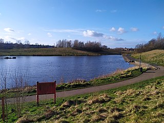
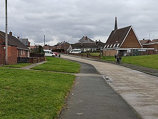
Gilley Law or otherwise known as Lakeside Village is a neighbourhood in Sunderland, England. [1]
Gilley Law or otherwise known as Lakeside Village is a neighbourhood in Sunderland, England. [1]
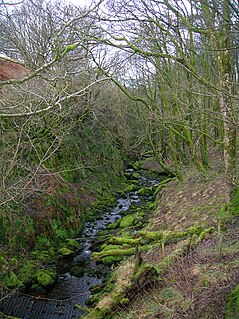
Gilley Law is situated to the Southwest of Sunderland City Centre and is bordered by Farringdon, New Silksworth and Doxford Park. The stream Hendon Burn runs directly through the suburb and goes underneath the housing area.
The term Gilley is derived from the old Norse term Gill (ravine) which refers to a form of valley or ravine, [2] whilst "Law" refers to a hill. This makes the literal name of the suburb "Hill Valley".

A valley is an elongated low area often running between hills or mountains, which will typically contain a river or stream running from one end to the other. Most valleys are formed by erosion of the land surface by rivers or streams over a very long period of time. Some valleys are formed through erosion by glacial ice. These glaciers may remain present in valleys in high mountain or polar areas. At lower latitudes and altitudes, these glacially formed valleys may have been created or enlarged during ice ages but now are ice-free and occupied by streams or rivers. In desert areas, valleys may be entirely dry or carry a watercourse only rarely. In areas of limestone bedrock, dry valleys may also result from drainage taking place underground rather than at the surface. Rift valleys arise principally from earth movements, rather than erosion. Many different types of valley are described by geographers, using terms that may be global in use or else applied only locally.
A glen is a valley, typically one that is long and bounded by gently sloped concave sides, unlike a ravine, which is deep and bounded by steep slopes. Whittow defines it as a "Scottish term for a deep valley in the Highlands" that is "narrower than a strath". The word is Goidelic in origin: gleann in Irish and Scottish Gaelic, glion in Manx. The designation "glen" also occurs often in place names.
Hilton or Hylton may refer to:

A fell is a high and barren landscape feature, such as a mountain or moor-covered hill. The term is most often employed in Norway, Fennoscandia, Iceland, the Isle of Man, parts of northern England, and Scotland.
Ryhope is a coastal village along the southern boundary of the City of Sunderland, in Tyne and Wear, North East England. With a population of approximately 14,000, measured at 10.484 in the 2011 census, Ryhope is 2.9 miles to the centre of Sunderland, 2.8 miles to the centre of Seaham, and 1.2 miles from the main A19.
A gill is an aquatic respiratory organ.

A ravine is a landform that is narrower than a canyon and is often the product of streambank erosion. Ravines are typically classified as larger in scale than gullies, although smaller than valleys. Ravines may also be called a cleuch, dell, ghout (Nevis), gill or ghyll, glen, gorge, kloof, and chine

Clough Head is a fell, or hill, in the English Lake District. It marks the northern end of the main ridge of the Helvellyn range and is often walked as part of the ridge walk. The fell stands south of the village of Threlkeld and the A66 road, and it forms the steep eastern side of the tranquil valley of St John's in the Vale.

In physical geography, a dell is a small secluded hollow, grassy, park-like, usually partially-wooded valley. The word "dell" comes from the Old English word dell, which is related to the Old English word dæl, modern 'dale'. Dells in literature are often portrayed as pleasant safe havens. The term is sometimes used interchangeably with dingle, although this specifically refers to deep ravines or hollows that are embowered with trees. The terms have also been combined to form examples of tautological placenames in Dingle Dell, Kent, and Dingle Dell Reserve, Auckland.
Silksworth is a suburb of the City of Sunderland, Tyne and Wear. The area can be distinguished into two parts, old Silksworth, the original village and township which has existed since the early middle ages, and New Silksworth, the industrial age colliery village which expanded north west of the original settlement. The former colliery being situated to the north west of the village near to the Gilley Law. The population of the ward was 10,931 at the 2011 census. The town is best know for stealing a pit wheel that stood in washington for 52 years claiming it belongs to silksworth, however nobody in the town knew about it prior to a local council worker campaigning to "bring the wheel home", this project has cost £25,000 and has soured the relationship between washington and silksworth.

Mount Richon is a suburb of Perth, Western Australia in the City of Armadale. Formerly part of Armadale and Wungong, Mount Richon was approved as a suburb in 2003. It occupies the western slope of the Darling Range from the intersection of Albany and South Western Highways south to Leys Rise, is bounded on the west by South-Western Highway and is bounded on the east by Albany Highway and Bungendore Park. Mount Richon is named after a vineyard that formerly existed in the area.
Farringdon is a suburb of Sunderland, Tyne and Wear, England. Originally a Monastic grange and manor estate for hundreds of years, Farringdon was rebuilt as a post-war council housing estate in the 1950s. It is approximately 3 mi (4.8 km) south of the city centre along the A690, close to Thorney Close, Silksworth, East Herrington, Gilley Law and Doxford Park. Electorally, the area comes under the St. Chad's ward of the City.
Barrow is small fell in the English Lake District in the county of Cumbria which reaches a height of 455 metres (1,494 feet). It is in the Newlands Valley 2.5 miles (4 km) south-west of Keswick. Although comparatively small in height, Barrow commands an all-round view, with the vales of Keswick and Newlands being visible. The name of the fell originates from the Anglo Saxon language meaning a hill or long ridge.
A gill or ghyll is a ravine or narrow valley in the North of England and other parts of the United Kingdom. The word originates from the Old Norse gil. Examples include Dufton Ghyll Wood, Dungeon Ghyll, Troller's Gill and Trow Ghyll. As a related usage, Gaping Gill is the name of a cave, not the associated stream, and Cowgill, Masongill and Halton Gill are derived names of villages.
Pine Hill is a suburb, hill, and general area of the New Zealand city of Dunedin. It is sited on the hill of the same name, a spur of Mount Cargill overlooking North East Valley and Glenleith 4 kilometres (2.5 mi) to the north of the city centre. This spur lies in the fork of the confluence of the Water of Leith and its largest tributary, the Lindsay Creek. The term Pine Hill is used generally to refer to a group of suburbs which lie on the hill's slopes: Pine Hill suburb itself, which sits on the upper slopes of the spur, and also two other suburbs which lie on the lower slopes, Dalmore and Liberton.

In geography, a defile is a narrow pass or gorge between mountains or hills. The term originates from a military description of a route through which troops can march only in a narrow column or with a narrow front. On emerging from a defile into open country, soldiers are said to "debouch".

The River Wear in North East England rises in the Pennines and flows eastwards, mostly through County Durham to the North Sea in the City of Sunderland. At 60 mi (97 km) long, it is one of the region's longest rivers, wends in a steep valley through the cathedral city of Durham and gives its name to Weardale in its upper reach and Wearside by its mouth.

Hendon Burn is a stream flowing through Sunderland, Tyne and Wear. serving as a drainage basin for most of the city's southern half, its route proceeds from Doxford Park through the Farringdon Country Park area and into Gilley Law, Silksworth, Barnes, Ashbrooke and Backhouse Park before reaching the sea at Hendon.

Arn Gill is a ravine or gully containing a beck of the same name, near the village of Muker in Swaledale, North Yorkshire, England. The ravine and beck run steeply downhill from the stream's source in Arn Gill Head, and the beck disgorges into the River Swale below.
| | This Tyne and Wear location article is a stub. You can help Wikipedia by expanding it. |