
Sunderland City Centre is the central business district in Sunderland, Tyne and Wear, England. [1] The city centre is just to the west of Sunderland Docks.
Sunderland City Centre is the central business district in Sunderland, Tyne and Wear, England. [1] The city centre is just to the west of Sunderland Docks.
In 2020 it was announced that 14 million would be spent on a new car park in the city centre. [2]
This section needs additional citations for verification .(May 2023) |

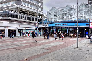
The city centre’s main area, it extends south from the Wear to the A1231, including Sunderland's major shops. It contains the market square, Elephant Tea Rooms, Sunderland station, High Street West and The Bridges Shopping Centre. The former Sunderland Civic Centre site is being redeveloped.
Monkwearmouth is north of the River Wear. It is best known for being the home of the Stadium of Light, St Peter’s Church and the University of Sunderland St Peter’s campus. The area is mainly made up of residential properties and light industry, and to the north merges into outer residential areas.
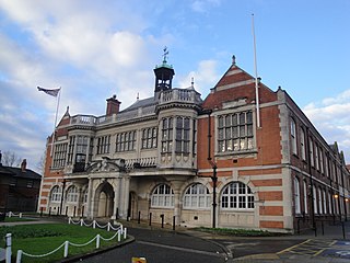
Bishopwearmouth is the western end of the centre. Known for being the home of the city hall, magistrates court, Keel Square, minster and the University of Sunderland city campus. The area’s west merges into outer residential areas.
Hendon is the centre’s east end. It is home to the Town Moor, Sunderland Docks and the former Sunderland Barracks. The area’s north is also called the East End while to the south it merges into outer residential areas.
Sunniside is the centre’s closest residential area. With merchant terraces and Mowbray Park to the south. It extents from Fawcett Street to the A1018. The area contains Sunderland Empire Theatre and the Sunderland Museum and Winter Gardens.
Sunderland City Centre is part of the Sunderland Central parliamentary constituency.
For local elections, it is currently divided between three wards of the city council. The majority of the city centre, lying to the west of Fawcett Street and the north of Holmeside, is located in Millfield ward. The eastern parts of the centre beyond Fawcett Street form part of Hendon ward, while the south of the city centre around Park Lane is within St Michael's ward.
Hendon is an urban area in the London Borough of Barnet, northwest London 7 miles (11 km) northwest of Charing Cross. Hendon was an ancient manor and parish in the county of Middlesex and a former borough, the Municipal Borough of Hendon; it has been part of Greater London since 1965. Hendon falls almost entirely within the NW4 postcode, while the West Hendon part falls in NW9. Colindale to the northwest was once considered part of Hendon but is today separated by the M1 motorway.

Sunderland is a port city in Tyne and Wear, England. It is a port at the mouth of the River Wear on the North Sea, approximately 10 miles (16 km) south-east of Newcastle upon Tyne. The built-up area had a population of 168,277 at the 2021 census, making it the second largest settlement in North East England after Newcastle. It is the administrative centre of the metropolitan borough of the same name.

Gateshead is a town in the Gateshead Metropolitan Borough of Tyne and Wear, England. It is on the River Tyne's southern bank. The town's attractions include the twenty metre tall Angel of the North sculpture on the town's southern outskirts, The Glasshouse International Centre for Music and the Baltic Centre for Contemporary Art. The town shares the Millennium Bridge, Tyne Bridge and multiple other bridges with Newcastle upon Tyne.

Cardiff city centre is the city centre and central business district of Cardiff, Wales. The area is tightly bound by the River Taff to the west, the Civic Centre to the north and railway lines and two railway stations – Central and Queen Street – to the south and east respectively. Cardiff became a city in 1905.

Roker is a seaside resort of Sunderland, city of Sunderland district, Tyne and Wear. England. It is north of the River Wear's mouth and Monkwearmouth, west of the North Sea, east of Fulwell and Seaburn is south. It lies within historic County Durham.
Dunedin is a city of 136,000 people in the South Island of New Zealand. The principal suburbs of Dunedin are as follows. Inner and outer suburbs are ordered by location, clockwise from the city centre, starting due north:
The Greater Richmond, Virginia area has many neighborhoods and districts.

Leicester City Centre is Leicester's historical commercial, cultural and transport hub and is home to its central business district. Its inner core is roughly delineated by the A594, Leicester's inner ring road, although the various central campuses of the University of Leicester, De Montfort University and Leicester College are adjacent to the inner ring road and could be considered to be a continuation of the City centre. In a similar way, the Leicester Royal Infirmary precinct, New Walk business district (Southfields), the Welford Road Stadium of Leicester Tigers’ RUFC and the King Power Stadium of Leicester City to the south, and the Golden Mile to the north could also be deemed to be extensions to the central core.
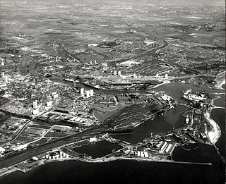
Hendon is an eastern area of Sunderland in Tyne and Wear, North East England, the location of much heavy industry and Victorian terraces and three high-rise residential tower blocks. The area is commonly referred to as the East End of Sunderland. Hendon is west of Sunderland Docks.
Swansea city centre in Swansea, Wales, contains the main shopping, leisure and nightlife district in Swansea. The city centre covers much of the Castle ward including the area around Oxford Street, Castle Square, and the Quadrant Shopping Centre; Alexandra Road, High Street, Wind Street and the Castle; Parc Tawe; and the Maritime Quarter extending down to the seafront.

Sunderland is a railway and metro station in Sunderland, Tyne and Wear, England. It is on the Durham Coast Line, which runs between Middlesbrough and Newcastle, via Hartlepool. It is owned by Network Rail and managed by Northern Trains. Since 31 March 2002, the station has also been served by the Tyne and Wear Metro's Green Line.

Sunderland Central is a constituency in the House of Commons of the UK Parliament. It is represented by the Labour Party MP Lewis Atkinson, who has held the seat since 2024.

Sunderland City Council is the local authority of Sunderland, a metropolitan borough with city status in the ceremonial county of Tyne and Wear in North East England. It is one of five such councils in Tyne and Wear and one of 36 in England. It provides the majority of local government services in Sunderland.

Elections to the Preston City Council took place on 3 May 2007.

Thorney Close is a suburb of Sunderland, Tyne and Wear in England.

The A1231 road connects Sunderland and Washington in Tyne and Wear, North East England. It is the main road connecting these towns and is one of the main roads giving access to Sunderland city centre.

The A1018 is a road in North East England. It runs between South Shields, at the mouth of the River Tyne, and the A19 near Seaham, County Durham. Most of the route it follows is the old alignment of the A19, before it by-passed Sunderland to meet the Tyne Tunnel.
The Bridges Shopping Centre, commonly known as ‘The Bridges’ is a shopping centre located in Sunderland, England. The centre was opened by Princess Royal, Anne in 1988.

Brighton and Hove City Centre is the commercial and cultural centre of the city of Brighton and Hove. Geographically, the so-called city centre is located in an easterly part of the Brighton and Hove urban conurbation.

In 685, King Ecgfrith granted Benedict Biscop a "sunder-land". Also in 685 The Venerable Bede moved to the newly founded Jarrow monastery. He had started his monastic career at Monkwearmouth monastery and later wrote that he was "ácenned on sundorlande þæs ylcan mynstres". This can be taken as "sundorlande" or the settlement of Sunderland. Alternatively, it is possible that Sunderland was later named in honour of Bede's connections to the area by people familiar with this statement of his.
| | This Tyne and Wear location article is a stub. You can help Wikipedia by expanding it. |