
The United States Postal Service is an independent agency of the executive branch of the United States federal government responsible for providing postal service in the United States, including its insular areas and associated states. It is one of the few government agencies explicitly authorized by the United States Constitution. The USPS, as of 2021, has 516,636 career employees and 136,531 non-career employees.

A postal code is a series of letters or digits or both, sometimes including spaces or punctuation, included in a postal address for the purpose of sorting mail.

A ZIP Code is a postal code used by the United States Postal Service (USPS). Introduced in 1963, the basic format consisted of five digits. In 1983, an extended ZIP+4 code was introduced; it included the five digits of the ZIP Code, followed by a hyphen and four digits that designated a more specific location.

The London postal district is the area in England of 241 square miles (620 km2) to which mail addressed to the London post town is delivered. The General Post Office under the control of the Postmaster General directed Sir Rowland Hill to devise the area in 1856 and throughout its history it has been subject to reorganisation and division into increasingly smaller postal units, with the early loss of two compass points and a minor retraction in 1866. It was integrated by the Post Office into the national postcode system of the United Kingdom during the early 1970s and corresponds to the N, NW, SW, SE, W, WC, E and EC postcode areas. The postal district has also been known as the London postal area. The County of London was much smaller, at 117 square miles (300 km2), but Greater London is much larger at 607 square miles (1,570 km2).

A Canadian postal code is a six-character string that forms part of a postal address in Canada. Like British, Irish and Dutch postcodes, Canada's postal codes are alphanumeric. They are in the format A1A 1A1, where A is a letter and 1 is a digit, with a space separating the third and fourth characters. As of October 2019, there were 876,445 postal codes using Forward Sortation Areas from A0A in Newfoundland to Y1A in the Yukon.
A Postal Index Number (PIN), or sometimes redundantly a PIN code, refers to a six-digit code in the Indian postal code system used by India Post.
On 26 June 1964, Swiss Post introduced postal codes as the third country after Germany (1941) and the United States (1963).
Postal codes were introduced in France in 1964, when La Poste introduced automated sorting. They were updated to use the current 5 digit system in 1972.
An address is a collection of information, presented in a mostly fixed format, used to give the location of a building, apartment, or other structure or a plot of land, generally using political boundaries and street names as references, along with other identifiers such as house or apartment numbers and organization name. Some addresses also contain special codes, such as a postal code, to make identification easier and aid in the routing of mail.
Ukraine uses five-digit numeric postal codes that are written immediately to the right of the city or settlement name.

The postal history of Morocco is complex due to the country's political development in the 20th century. Mails were sent via post offices operated by the Sherifan post created by the Sultan, and by the European powers. After the partition of Morocco into French and Spanish protectorate and the international zone of Tangier in 1912, France and Spain established postal services in their respective zones.

Papua New Guinea has 326 local-level governments (LLGs) comprising 6,112 wards as of 2018.
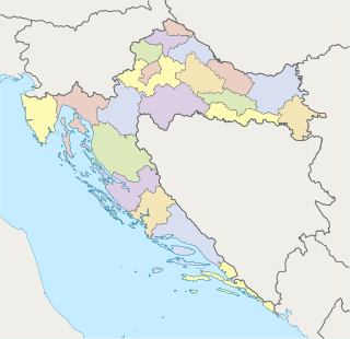
Postal codes in Croatia are 5 digit numeric. There are 20 two digit zones defined. Zagreb City and Zagreb County have one, each other first level administrative country subdivision, i.e. one of the counties of Croatia, has its own range.

Postal codes in Hungary are four digit numeric. The first digit is for the postal region, as listed below :

This is a survey of the postage stamps and postal history of Sudan. Sudan was governed by the United Kingdom and Egypt from 1898. Independence was proclaimed on January 1, 1956. Independent Sudan became a member of the Universal Postal Union (UPU) on 27 July 1956.

This is a survey of the postage stamps and postal history of Syria.
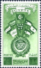
This is a survey of the postage stamps and postal history of Egypt.
Postal codes were adopted in Ghana on 18 October 2017, following the launch of the National Digital Address System. As a joint venture between Ghana Post and Vokacom Ltd as GhanaPost GPS, the Digital Address System assigned postal codes and unique addresses to every square in Ghana.

Pirappan Valasai is a village in Mandapam block in Ramanathapuram District of Tamil Nadu, India.
This page is based on this
Wikipedia article Text is available under the
CC BY-SA 4.0 license; additional terms may apply.
Images, videos and audio are available under their respective licenses.