Related Research Articles

Orange County, often known by its initials O.C., is a county located in the Los Angeles metropolitan area in Southern California, United States. As of the 2020 census, the population was 3,186,989, making it the third-most-populous county in California, the sixth-most-populous in the United States, and more populous than 19 American states and Washington, D.C. Although largely suburban, it is the second-most-densely-populated county in the state behind San Francisco County. The county's three most-populous cities are Anaheim, Santa Ana, and Irvine, each of which has a population exceeding 300,000. Santa Ana is also the county seat. Six cities in Orange County are on the Pacific coast: Seal Beach, Huntington Beach, Newport Beach, Laguna Beach, Dana Point, and San Clemente.

Southern California is a geographic and cultural region that generally comprises the southern portion of the U.S. state of California. It includes the Los Angeles metropolitan area as well as the Inland Empire. The region generally contains ten of California's 58 counties: Imperial, Kern, Los Angeles, Orange, Riverside, San Bernardino, San Diego, Santa Barbara, San Luis Obispo and Ventura counties.

Los Angeles County, officially the County of Los Angeles, and sometimes abbreviated as L.A. County, is the most populous county in the United States, with 9,861,224 residents estimated in 2022. Its population is greater than that of 40 individual U.S. states. Comprising 88 incorporated cities and many unincorporated areas within a total area of 4,083 square miles (10,570 km2), it is home to more than a quarter of Californians and is one of the most ethnically diverse U.S. counties. The county's seat, Los Angeles, is the second most populous city in the United States, with 3,822,238 residents estimated in 2022.

Greater Los Angeles is the most populous metropolitan statistical area in the U.S. state of California, encompassing five counties in Southern California extending from Ventura County in the west to San Bernardino County and Riverside County in the east, with Los Angeles County in the center, and Orange County to the southeast. The Los Angeles–Anaheim–Riverside combined statistical area covers 33,954 square miles (87,940 km2), making it the largest metropolitan region in the United States by land area. With a population of 18.5 million in 2021, it is the second-largest metropolitan area in the United States. The contiguous urban area is 2,281 square miles (5,910 km2), whereas the remainder mostly consists of mountain and desert areas.
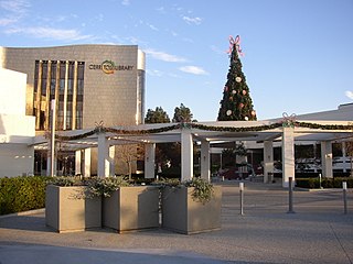
Cerritos is a city in Los Angeles County, California, United States, and is one of several cities that constitute the Gateway Cities of southeast Los Angeles County. It was incorporated on April 24, 1956. As of 2019, the population was 49,859. It is part of the Los Angeles–Long Beach–Anaheim, California Metropolitan Statistical Area designated by the Office of Management and Budget.

Commerce is a city located in southeast Los Angeles County, California, United States. The population was 12,823 at the 2010 census, up from 12,568 at the 2000 census. It is usually referred to as the City of Commerce to distinguish it from the common noun. It is bordered by Vernon on the west, Los Angeles on the northwest, East Los Angeles on the north, Montebello on the east, Downey and Bell Gardens on the south, and Maywood on the southwest. The Los Angeles River forms part of its southwestern boundary, and the Rio Hondo separates it from Downey. Commerce is served by the Long Beach and Santa Ana freeways, as well as the Metrolink commuter rail service at the Commerce station.

Downey is a city located in Southeast Los Angeles County, California, United States, 13 mi (21 km) southeast of Downtown Los Angeles. It is considered part of the Gateway Cities. The city is the birthplace of the Apollo space program. It is also the home of the oldest operating McDonald's restaurant in the world. As of the 2020 census, the city had a total population of 114,355.
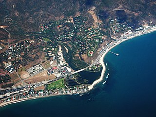
Malibu is a beach city in the Santa Monica Mountains region of Los Angeles County, California, about 30 miles (48 km) west of Downtown Los Angeles. It is known for its Mediterranean climate, its strip of beaches stretching 21 miles along the Pacific Ocean coast, and for its longtime status as the home of numerous affluent Hollywood celebrities and executives. Although a high proportion of its residents are entertainment industry figures with million-dollar mansions, Malibu also features several middle- and upper-middle-class neighborhoods. The Pacific Coast Highway traverses the city and has led most residents to settle anywhere from half a mile to within a few hundred yards of it, with some residents living up to one mile away from the beach in areas featuring narrow canyons. As of the 2020 census, the city's population was 10,654.

Norwalk is a city in Los Angeles County, California, United States. The population was 102,773 at the 2020 census.

Pico Rivera is a city located in southeastern Los Angeles County, California. The city is situated approximately 11 miles (18 km) southeast of downtown Los Angeles, on the eastern edge of the Los Angeles basin, and on the southern edge of the area known as the San Gabriel Valley. As of the 2020 United States census, the city has a population of 62,088. Pico Rivera is bordered by Montebello to the west, Downey to the south, Santa Fe Springs to the southeast, and Whittier to the east. Northrop Grumman's Advanced Systems Division developed the B-2 Spirit bomber here.

Whittier is a city in Southern California in Los Angeles County, part of the Gateway Cities. The 14.7-square-mile (38.0 km2) city had 87,306 residents as of the 2020 United States census, an increase of 1,975 from the 2010 census figure. Whittier was incorporated in February 1898 and became a charter city in 1955. The city is named for the Quaker poet John Greenleaf Whittier and is home to Whittier College.

The San Gabriel Valley, often referred to by its initials as SGV, is one of the principal valleys of Southern California, with the city of Los Angeles directly bordering it to the west, and occupying the vast majority of the southeastern part of Los Angeles County. Surrounding landforms and other features include the following:

The Whittier Narrows is a narrows or water gap in the San Gabriel Valley of Los Angeles County, California, United States, between the Puente Hills to the east and the Montebello Hills to the west. The gap is located at the southern boundary of the San Gabriel Valley, through which the Rio Hondo and the San Gabriel River flow to enter the Los Angeles Basin. The Narrows is located near the convergence of Interstate 605 and California State Route 60.
Districts in California geographically divide the U.S. state into overlapping regions for political and administrative purposes.
The following is a timeline of the history of the city of Long Beach, California, USA.
The following is a timeline of the history of the city of Anaheim, California, US.
The following is a timeline of the history of the city of Santa Ana, California, USA.
References
- ↑ "About Us". Whittier, CA - Public Library. whittierlibrary.org. Retrieved 30 March 2022.
- ↑ "About Us". Whittier Public Library Foundation. Retrieved 30 March 2022.