
Mount Waddington, once known as Mystery Mountain, is the highest peak in the Coast Mountains of British Columbia, Canada. Although it is lower than Mount Fairweather and Mount Quincy Adams, which straddle the United States border between Alaska and British Columbia, Mount Waddington is the highest peak that lies entirely within British Columbia. It and the subrange which surround it, known as the Waddington Range, stand at the heart of the Pacific Ranges, a remote and extremely rugged set of mountains and river valleys.

The Canadian Rockies or Canadian Rocky Mountains, comprising both the Alberta Rockies and the British Columbian Rockies, is the Canadian segment of the North American Rocky Mountains. It is the easternmost part of the Canadian Cordillera, which is the northern segment of the North American Cordillera, the expansive system of interconnected mountain ranges between the Interior Plains and the Pacific Coast that runs northwest–southeast from central Alaska to the Isthmus of Tehuantepec in Mexico.
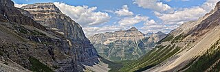
Kootenay National Park is a national park of Canada in southeastern British Columbia. The park consists of 1,406 km2 (543 sq mi) of the Canadian Rockies, including parts of the Kootenay and Park mountain ranges, the Kootenay River and the entirety of the Vermilion River. While the Vermilion River is completely contained within the park, the Kootenay River has its headwaters just outside the park boundary, flowing through the park into the Rocky Mountain Trench and eventually joining the Columbia River. The park ranges in elevation from 918 m (3,012 ft) at the southwestern park entrance to 3,424 m (11,234 ft) at Deltaform Mountain.

The Northern and Central Bitterroot Range, collectively the Bitterroot Mountains, is the largest portion of the Bitterroot Range, part of the Rocky Mountains and Idaho Batholith, located in the panhandle of Idaho and westernmost Montana in the northwestern United States. The mountains encompass an area of 4,862 square miles (12,593 km2).

Howse Pass is a pass through the Rocky Mountains in Canada. The pass is located in Banff National Park, between Mount Conway and Howse Peak. From here waters flow east via Conway Creek, Howse River, North Saskatchewan River to Lake Winnipeg and Hudson Bay. To the west it drains by the Blaeberry River to the Columbia River and on to the Pacific Ocean.

The Pacific Ranges are the southernmost subdivision of the Coast Mountains portion of the Pacific Cordillera. Located entirely within British Columbia, Canada, they run northwest from the lower stretches of the Fraser River to Bella Coola and Burke Channel, north of which are the Kitimat Ranges. The Coast Mountains lie between the Interior Plateau and the Coast of British Columbia.

The Chilcotin Ranges are a subdivision of the Pacific Ranges of the Coast Mountains. They lie on the inland lea of the Pacific Ranges, abutting the Interior Plateau of British Columbia. Their northwestern end is near the head of the Klinaklini River and their southeast end is the Fraser River just north of Lillooet; their northern flank is the edge of the Plateau while their southern is the north bank of the Bridge River. In some reckonings they do not go all the way to the Fraser but end at the Yalakom River, which is the North Fork of the Bridge.

The Pantheon Range is a subrange of the Pacific Ranges of the Coast Mountains in British Columbia. It is located between the edge of the Chilcotin Plateau at Tatla Lake on its northeast and the Klinaklini River on its west, with a southeastern boundary along Mosley Creek, a major tributary of the Homathko River. The range is 5550 km2 in area and extremely rugged, with many sharp, glaciated peaks.

The Waddington Range is a subrange of the Pacific Ranges of the Coast Mountains in southwestern British Columbia, Canada. It is only about 4,000 km2 in area, relatively small in area within the expanse of the range, but it is the highest area of the Pacific Ranges and of the Coast Mountains, being crowned by its namesake Mount Waddington 4,019 m (13,186 ft). The Waddington Range is also extremely rugged and more a complex of peaks than a single icefield, in contrast to the other huge icefield-massifs of the southern Coast Mountains, which are not so peak-studded and tend to have more contiguous icemasses.

The Niut Range is 3600 km2 in area. It is a subrange of the Pacific Ranges of the Coast Mountains of British Columbia, although in some classifications it is considered part of the Chilcotin Ranges. The Niut is located in the angle of the Homathko River and its main west fork, Mosley Creek. It is isolated, island-like, by those rivers from its neighbour ranges, as both streams have their source on the Chilcotin Plateau in behind the range. Razorback Mountain is its highest peak.

Monarch Mountain is one of the principal summits of the Pacific Ranges subdivision of the Coast Mountains in southern British Columbia. It stands just east of a pass between the Klinaklini River and the south branch of the Atnarko River, which is a tributary of the Bella Coola River. Surrounding Monarch Mountain is the Monarch Icefield, the northernmost of the major icefields of the Pacific Ranges, and just south of it is the Ha-Iltzuk Icefield, which is the largest. Monarch is in the southern end of Tweedsmuir South Provincial Park.
The Klinaklini River is one of the major rivers of the Pacific Ranges section of the Coast Mountains in the Canadian province of British Columbia. It originates in the Pantheon Range and empties into the head of Knight Inlet.

Hamber Provincial Park is a provincial park in British Columbia, Canada, located 130 kilometres (80.7 mi) north of Golden. Straddling the Great Divide on the provincial boundary with Alberta, the park is surrounded on three sides by Jasper National Park and protects the headwaters of the Wood River at Fortress Lake.

Sheep River Provincial Park is a provincial park located in Alberta, Canada, 23 kilometres (14 mi) west of Diamond Valley on highway 546. It is part of the Kananaskis Country park system and encompasses a portion of the Sheep River valley.

The Hart Ranges are a major subrange of the Canadian Rockies located in northeastern British Columbia and western Alberta. The mountains constitute the southernmost portion of the Northern Rocky Mountains.
The Thudaka Range is a mountain range located east of the Rocky Mountain Trench in British Columbia, Canada bounded by the Obo River on the east, the Frog River on the west, and on the south by the pass between Geese and Thudaka Creeks. The highest peak in the range is Thudaka Peak at 2,748 m (9,016 ft). The range is part of the Stikine Ranges.

The Ha-Iltzuk Icefield is an icefield in the central Pacific Ranges of the Coast Mountains in British Columbia, Canada. It is the largest icefield in the Coast Mountains south of the Alaska Panhandle, with an area of 3,610 km2 (1,390 sq mi). It is located on the west side of the Klinaklini River and the Waddington Range. The highest summit in the icefield is Mount Silverthrone, which is a mountain on the northeast edge of a circular, 20 km (12 mi) wide, deeply dissected caldera complex called the Silverthrone Caldera.
The Lizard Range is a mountain range southwest of Fernie, British Columbia in the Canadian Rockies. The range is home to the Fernie Alpine Resort and parts of the Mount Fernie Provincial Park.