
This is a list of major roads in Ottawa, Ontario, Canada.
This is a list of major roads in Ottawa, Ontario, Canada.
The City of Ottawa classifies its roads in one of the following categories:
![]() signifies roads under federal government jurisdiction.
signifies roads under federal government jurisdiction.
![]() A King's Highway sign indicates a provincial road. (See Highways in Ontario for more information.)
A King's Highway sign indicates a provincial road. (See Highways in Ontario for more information.)
Roads without an identifying icon are of unconfirmed classification

Bank Street is the major commercial north–south street in Ottawa, Ontario, Canada. It runs south from Wellington Street in downtown Ottawa, south through the neighbourhoods of Centretown, The Glebe, Old Ottawa South, Alta Vista, Hunt Club, and then through the villages of Blossom Park, Leitrim, South Gloucester, Greely, Metcalfe, Spring Hill, and Vernon before ending at the city limit at Belmeade Road, becoming Stormont, Dundas and Glengarry county highway 31.

Hunt Club Road, also known as Ottawa Road 32, is a major east–west route in Ottawa, Ontario, Canada. It originally ran from a dead end east of Bank Street to the Ottawa Hunt and Golf Club; later, there were many extensions due to the 1970s housing boom, first westward to Riverside Drive, then eastward to Hawthorne Road in the late 1980s. The section between Bank Street and Riverside Drive, originally only one lane in each direction, was expanded to two lanes in each direction in 1993–1994. It was further extended across the Rideau River and the southern edge of the suburbs to Richmond Road by the late 1990s; this extension is signed as West Hunt Club Road by the City of Ottawa. Construction to extend Hunt Club eastward to Highway 417 near Ramsayville was completed on August 21, 2014.

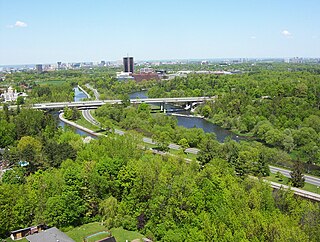
Riverside Drive is a major road in Ottawa, Ontario, Canada, that follows along the eastern bank of the Rideau River. Its northern terminus is at the Transitway/Via Rail underpass just south of the Queensway, and the road proceeds south to Limebank Road where it continues as River Road until the city limits. North of the Queensway, Riverside continues as Vanier Parkway, which travels through Vanier until Beechwood Avenue. The Vanier Parkway name is linked to the neighbourhood of Vanier, which was named for former Governor General of Canada Georges Vanier.

Sussex Drive, also known as Ottawa Regional Road 93, is an arterial road in Ottawa, Ontario, the capital of Canada. It is one of the city's main ceremonial and institutional routes. Travelling roughly parallel to the Ottawa River, Sussex Drive begins as a continuation of Sir George-Étienne Cartier Parkway at Rideau Gate, at the entrance to Rideau Hall. It travels south to Rideau Street, with the portion south of St. Patrick Street forming the northbound half of a one-way pair with Mackenzie Avenue. Both Mackenzie Avenue and Sussex Drive connect with Colonel By Drive at their southern end, which continues south alongside the Rideau Canal.
Russell Road is an arterial road in Eastern Ontario, Canada. It begins in Ottawa in the Riverview neighbourhood and runs eastward through the rural communities of Ramsayville, Carlsbad Springs and Bearbrook in Ottawa and through the Municipality of Clarence-Rockland, connecting the communities of Cheney and Bourget, ending at Boundary Road on the eastern border of Clarence Rockland. In Ottawa it is officially Ottawa Road #26, and in Clarence-Rockland as United Counties of Prescott and Russell County Road #2.
King's Highway 417, commonly referred to as Highway 417 and as the Queensway through Ottawa, is a 400-series highway in the Canadian province of Ontario. It connects Ottawa with Montreal via A-40, and is the backbone of the highway system in the National Capital Region. Within Ottawa, it forms part of the Queensway west from Highway 7 to Ottawa Road 174. Highway 417 extends from the Quebec border, near Hawkesbury, to Arnprior, where it continues westward as Highway 17. Aside from the urban section through Ottawa, Highway 417 passes through farmland that dominates much of the fertile Ottawa Valley.
Colonel By Drive is an 8.1 km (5.0 mi) long scenic parkway in Ottawa, Ontario, Canada.

Carleton is a federal electoral district in Ontario, Canada, represented in the House of Commons of Canada from 1867 to 1968 and since 2015. It was represented in the Legislative Assembly of Upper Canada from 1821 to 1840 and in the Legislative Assembly of the Province of Canada from 1841 until 1866. It has been represented by Pierre Poilievre, the current Leader of the Opposition, since its creation in 2015.

Queen Elizabeth Driveway is a scenic parkway in Ottawa, Ontario, Canada.
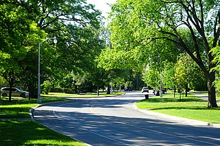
Island Park Drive is a scenic parkway in Ottawa, Ontario, Canada.
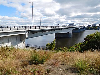
The Macdonald-Cartier Bridge is a bridge connecting Ottawa, Ontario, to Gatineau, Quebec. The bridge is a 618 m long continuous steel box girder bridge and carries six lanes of traffic. It links King Edward Avenue and Sussex Drive in Ottawa with Autoroute 5 in Quebec. It is the easternmost bridge linking Ottawa to Gatineau, running just east of the Alexandra Bridge.
Lower Town (also spelled "Lowertown" is a neighbourhood in Rideau-Vanier Ward in central Ottawa, Ontario, Canada, to the east of downtown. It is the oldest part of the city. It is bounded by Rideau Street to the south, the Ottawa River to the west and north and the Rideau River to the east. It includes the commercial Byward Market area in the south-western part, and is predominantly residential in the north and east.

Montreal Road, also known as Ottawa Road #34, is a major east-west Ottawa road that links Lowertown to Vanier and the farther eastern neighbourhoods of Ottawa. Until downloading in 1998, it was part of the provincially managed Highway 17B.
King's Highway 31, commonly referred to as Highway 31 and historically known as the Metcalfe Road, was a provincially maintained highway in the Canadian province of Ontario. The 76.93-kilometre (47.80 mi) route connected Highway 2 in Morrisburg with the Chaudière Bridge at the Ontario–Quebec boundary in downtown Ottawa.

King Edward Avenue is a major thoroughfare in the eastern part of Ottawa, Ontario, Canada. Despite being a municipal road, a portion of the street is designated as part of Canada's National Highway System, as part of an interconnecting route between Ontario Highway 417 in Ottawa and Quebec Autoroute 5 in Gatineau.
Highway 17B was formerly the designation for six business routes of Highway 17, the main route of the Trans-Canada Highway through the Canadian province of Ontario. Each generally followed the original route of Highway 17 through the town or city that it served, and was subsequently given the Highway 17B designation when a newer bypass route was constructed to either reduce traffic pressure on the local street network, or provide a better thoroughfare that avoided urban areas altogether.
| History |
|
|---|---|
| Geography | |
| Culture | |
| Public services | |
| Education | |
| Government | |
| Transportation and infrastructure | |
| Features | |