List of squares in Amsterdam

Last updated

.mw-parser-output .plainlist ol,.mw-parser-output .plainlist ul{line-height:inherit;list-style:none;margin:0;padding:0}.mw-parser-output .plainlist ol li,.mw-parser-output .plainlist ul li{margin-bottom:0}
A: Dam Square
B: Nieuwmarkt
C: Waterlooplein
D: Spui
E: Rembrandtplein
F: Koningsplein
G: Leidseplein
H: Museumplein
I: Marie Heinekenplein
J: Markenplein
K: Muntplein
L: Noordermarkt
M: Oudekerksplein Amsterdam map indicating squares - 01.png

There are over eighty squares or pleins in Amsterdam, Netherlands. This is a list of the most notable ones.

Contents

Major squares

Dam Square

Dam Square De Wallen, Dam Square - panoramio.jpg
Dam Square

Dam Square, also known as the Dam it is the main town square and considered to be the very center of the city. On the west edge of the square is the Royal Palace. It is roughly rectangular in shape, and stretches about 200 meters from west to east and about 100 meters from north to south. It links the streets Damrak and Rokin, which run along the original course of the Amstel River from Centraal Station to Muntplein (Mint Square) and the Munttoren (Mint Tower). The Dam also marks the endpoint of the other well-traveled streets Nieuwendijk, Kalverstraat and Damstraat. A short distance beyond the northeast corner lies the main red-light district: de Wallen.

The National Monument, a white stone pillar designed by J.J.P. Oud and erected in 1956 to memorialize the victims of World War II, dominates the opposite side of the square. Also overlooking the plaza are the NH Grand Hotel Krasnapolsky and the upscale department store De Bijenkorf. These various attractions have turned the Dam into a tourist zone.

Dijkgraafplein

Dijkgraafplein Amsterdam Dijkgraafplein Terminus Tram 17 20110424.jpg
Dijkgraafplein

Dijkgraafplein is located in Amsterdam-Osdorp at the end of Tussen Meer in the neighborhood that is now known as 'De Sharpen'. It is named after the office of dijkgraaf (the chairman of a waterboard) in 1962.

Koningsplein

Koningsplein in 2005 Koningsplein1.jpg
Koningsplein in 2005

Koningsplein is located between the Singel and Herengracht canals. It has become a meeting place for the local community. [1]

Leidseplein

Leidseplein Amsterdam, Stadsschouwburg, uitzicht op het Leidseplein03.JPG
Leidseplein

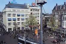
Leidseplein is located in the southwest of the Grachtengordel district immediately northeast of the Singelgracht canal. It is situated on the crossroads of the Weteringschans, the Marnixstraat, and the Leidsestraat. It is one of the busiest centres for nightlife in the city. Historically, the square was the end of the road from Leiden, and served as a parking lot for horse-drawn traffic. Today, modern traffic travels through the square and side streets are packed with restaurants and nightclubs. The Stadsschouwburg, a theater, is the most notable architectural landmark on the square, and the American Hotel is close by. [2]

Marie Heinekenplein

Marie Heinekenplein in June 2009 Marie Heinekenplein.jpg
Marie Heinekenplein in June 2009

Marie Heinekenplein is popularly known as Heinekenplein. This circle-shaped square is used for various events, such as a book market and an open-air cinema. It was constructed in the early 1990s. It lies just outside the city centre, in the neighbourhood of De Pijp, along the street Ferdinand Bolstraat. The street Quellijnstraat runs along the southern edge of the square. Tram lines 16 and 24 have a stop near the square.

Along the Marie Heinekenplein are a number of bars and cafés. The square is lined with café terraces. Between the square and the Stadhouderskade street is the former Heineken brewery, now a popular tourist attraction known as the Heineken Experience. Along the northern side of the square is a modern apartment building incorporating a supermarket and other shops at ground level. One of the three restaurants of renowned Chinese restaurant chain Nam Kee is located along the square.

Markenplein

Markenplein Markenlpein.jpg
Markenplein

Prior to 1970, Markenplein was named het oude Markenpleintje and before World War II it used to be a part of the Jewish district of Amsterdam. The name Markenplein symbolizes the bond between the new neighborhood and the old Jewish neighborhood.

The pavement pattern was designed by the American artist Sol LeWitt.

The square houses the entrance of the Netherlands Film and Television Academy, the parking garage Markenhoven and the Grand Cafe Allure.

Muntplein

Muntplein Munttoren (Amsterdam).JPG
Muntplein

Muntplein, often referred to simply as the "Munt", is in fact a bridge — the widest bridge in Amsterdam — which crosses the Singel canal at the point where it flows into the Amstel river. The square is a bustling intersection of six streets. It forms the southern end of the Kalverstraat shopping street and the major street Rokin. The eastern end of the floating flower market (Bloemenmarkt) along the Singel canal is directly south of the square.

Muntplein is named after the Munttoren (or simply Munt) tower which stands on this square.

Museumplein

Museumplein Dsc 0200 1 Jpg (151469793).jpeg
Museumplein

Museumplein is located in the Museumkwartier neighbourhood, beside three major museums – the Rijksmuseum, Van Gogh Museum, and Stedelijk Museum – and the concert hall Concertgebouw. [3]

Nieuwmarkt

Nieuwmarkt in 2002 Overzicht - Amsterdam - 20320090 - RCE.jpg
Nieuwmarkt in 2002

Nieuwmarkt (Dutch for "New Market" is located in Amsterdam's Chinatown, next to the De Wallen (Red Light District). It is dominated by a building known as the Waag. There are over 20 cafés and coffeeshops facing the square. There is a daily market on the square, as well as an organic food market on Saturdays and a market for antiques and books on Sundays in the summer months.

Noordermarkt

Noordermarkt ArianitAmsterdam17.jpg
Noordermarkt

Noordermarkt is located in the Jordaan neighborhood. It is lined by cafés and restaurants. Markets are held on the square every Monday. On Saturdays, a popular organic farmer's market is held on the square. On Mondays a market (mainly for textiles) is also held in the adjacent Westerstraat street.
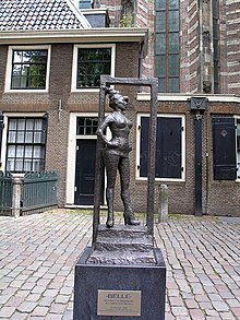
Oudekerksplein

The statue "Belle" on the Oudekerksplein. The plaque reads: "Respect sex workers all over the world" Sex worker statue Oudekerksplein Amsterdam.jpg
The statue "Belle" on the Oudekerksplein. The plaque reads: "Respect sex workers all over the world"

Oudekerksplein ("Old Church's Square") marks the eastern end of the Red Light District and is wedged between the Warmoesstraat street and Oudezijds Voorburgwal canal. From the square, the Oudekerksburg bridge crosses the Oudezijds Voorburgwal canal and continues eastwards, through the Oudekennissteeg and Molensteeg alleys, towards the Oudezijds Achterburgwal and Zeedijk.

Originally the Oudekerksplein was a graveyard. In 1655, the graveyard was cleared and moved to a new location beyond the city limits, creating the present square.

Rembrandtplein

Rembrandtplein after reconstruction 2009 NieuwRembrandtplein.JPG
Rembrandtplein after reconstruction 2009

Rembrandtplein (Rembrandt Square) is named after the famous painter Rembrandt van Rijn who owned a house nearby from 1639 to 1656.

Spui

The Spui (2008). On the right is the entrance to the Begijnhof Spui 3.jpg
The Spui (2008). On the right is the entrance to the Begijnhof

The Spui was originally a body of water that formed the southern limit of the city until the 1420s, when the Singel canal was dug as an outer moat around the city. In 1882 the Spui was filled in and became the square that we know today. In 1996 the square was renovated and is now largely car-free.

Waterlooplein

Waterlooplein flea market Amsterdam - Waterlooplein - Waterlooplein Market.jpg
Waterlooplein flea market

Waterlooplein is located near the Amstel river. The daily flea market on the square is popular with tourists. The Stopera city hall and opera building and the Mozes en Aäronkerk church are at Waterlooplein. The area of Amsterdam that includes Waterlooplein is also called Groot Waterloo district.

Comprehensive list

The following is a more comprehensive list:

Adam Smithplein, Alexanderplein, Amstelveld, Anton de Komplein, August Allebéplein, Barentzplein, Bellamyplein, Beursplein, Bijlmerplein, Boerhaaveplein, Brink, Concertgebouwplein, Dam Square, Emmaplein, Enkhuizerplein, Europaplein, Frederiksplein, Gerard Douplein, H.M. van Randwijkplantsoen, Haarlemmerplein, Hekelveld, Hendrik Jonkerplein, Henriëtte Ronnerplein, Hoofddorpplein, Hugo de Grootplein, Hygieaplein, Jacob Marisplein, Johannes Vermeerplein, Johnny Jordaanplein, Jonas Daniël Meijerplein, Julianaplein, Kadijksplein, Kattenburgerplein, Kleine-Gartmanplantsoen, Koekoeksplein, Koningsplein, Leidseplein, Markenplein, Max Euweplein, Meerhuizenplein, Mercatorplein, Merwedeplein, Minervaplein, Mr. Visserplein, Muntplein, Museumplein, Muzenplein, Nassauplein, Nieuwezijds Kolk, Nieuwmarkt, Noordermarkt, Olympiaplein, Oosterspoorplein, Osdorpplein, Oudekerksplein, Professor Tulpplein, Rapenburgerplein, Rembrandtplein, Roelof Hartplein, Scheldeplein, Sierplein, Smaragdplein, Spaarndammerplantsoen, Spui, Stadionplein, Stationsplein, Surinameplein, Thérèse Schwartzeplein, Thomas R. Malthusstraat, Thorbeckeplein, Valeriusplein, Van Limburg Stirumplein, Van Tuyll van Serooskerkenplein, Victorieplein, Waterlooplein, Weesperplein, Westermarkt, Weteringplantsoen, Wg-plein, Zaandammerplein, Zonneplein, and Zwanenplein.

See also

Related Research Articles

<span class="mw-page-title-main">Dam Square</span> Town square in Amsterdam

Dam Square or the Dam is a town square in Amsterdam, the capital of the Netherlands. Its notable buildings and frequent events make it one of the best-known and most important locations in the city and the country.

<i>Van der Valk</i> British TV crime drama set in Amsterdam

Van der Valk is a British television crime drama series produced for the ITV network. It ran from 1972 to 1992, with the first three series produced between 1972 and 1977, and two more being commissioned in 1991 and 1992.

<span class="mw-page-title-main">Rokin</span> Canal in Amsterdam

The Rokin is a canal and major street in the centre of Amsterdam. The street runs from Muntplein square to Dam square. The Rokin canal used to run from Muntplein square to Dam Square, but in 1936, the part between Spui square and Dam Square was filled in. Canal boats are now moored on the remaining part of the water, from the Amstel to Grimburgwal.

<span class="mw-page-title-main">Munttoren</span>

The Munttoren or Munt[mʏnt] is a tower in Amsterdam, Netherlands. It stands on the busy Muntplein square, where the Amstel river and the Singel canal meet, near the flower market and the eastern end of the Kalverstraat shopping street.

<span class="mw-page-title-main">Singel</span> Street and canal in Amsterdam

The Singel is one of the canals of Amsterdam. The Singel encircled Amsterdam in the Middle Ages, serving as a moat around the city until 1585, when Amsterdam expanded beyond the Singel. The canal runs from the IJ bay, near the Central Station, to the Muntplein square, where it meets the Amstel river. It is now the inner-most canal in Amsterdam's semicircular ring of canals.

<span class="mw-page-title-main">Kalverstraat</span> Street in Amsterdam, Netherlands

The Kalverstraat is a busy shopping street of Amsterdam, the capital of the Netherlands. The street runs roughly North-South for about 750 meters, from Dam Square to Muntplein square.

<span class="mw-page-title-main">Spui (Amsterdam)</span>

The Spui is a square in the centre of Amsterdam, the capital of the Netherlands.

<span class="mw-page-title-main">Canals of Amsterdam</span> Grachten dug in the 17th century during the Dutch Golden Age; UNESCO World Heritage Site

Amsterdam, capital of the Netherlands, has more than 100 kilometers (62 mi) of grachten (canals), about 90 islands and 1,500 bridges. The three main canals, dug in the 17th century during the Dutch Golden Age, form concentric belts around the city, known as the Grachtengordel. Alongside the main canals are 1550 monumental buildings. The 17th-century canal ring area, including the Prinsengracht, Keizersgracht, Herengracht and Jordaan, were listed as UNESCO World Heritage Site in 2010, contributing to Amsterdam's fame as the "Venice of the North".

<span class="mw-page-title-main">Muntplein, Amsterdam</span> Square in Amsterdam, Netherlands

The Muntplein is a square in the centre of Amsterdam. The square is in fact a bridge — the widest bridge in Amsterdam — that crosses the Singel canal at the point where it flows into the Amstel river. All bridges in Amsterdam are numbered, and the Muntplein carries the number 1.

<span class="mw-page-title-main">Oudekerksplein</span>

The Oudekerksplein is a square in the centre of Amsterdam. It is named after the 14th-century church Oude Kerk which dominates the square. The Oudekerksplein is wedged between the Warmoesstraat street and Oudezijds Voorburgwal canal. From the square, the Oudekerksbrug bridge crosses the Oudezijds Voorburgwal canal and continues eastwards, through the Oudekennissteeg and Molensteeg alleys, towards the Oudezijds Achterburgwal and Zeedijk.

<span class="mw-page-title-main">Nieuwezijds Voorburgwal</span> Street in Amsterdam

The Nieuwezijds Voorburgwal is a street in the centre of Amsterdam. The street runs north-south without intersecting major streets other than the intersection with Raadhuisstraat at its halfway point, right behind the Royal Palace. On the eastern side it has a number of alleys connecting to Kalverstraat and Nieuwendijk.

<span class="mw-page-title-main">Walls of Amsterdam</span> Series of historic walls built around the city of Amsterdam, Netherlands

The walls of Amsterdam were built in the Middle Ages to protect the city against attack. The Medieval walls were replaced with a series of bastions in the 17th century. In the 19th century, the walls were torn down and replaced with the Defence Line of Amsterdam, a fortification line which encircled Amsterdam at a distance from the city.

<span class="mw-page-title-main">Nieuwendijk, Amsterdam</span> Street in Amsterdam

The Nieuwendijk is a major shopping street in central Amsterdam. There are some 200 shops along the street. The street, which dates to the early medieval history of Amsterdam, counts 98 buildings with rijksmonument status.

<span class="mw-page-title-main">Oudezijds Voorburgwal</span> Canal in Amsterdam

The Oudezijds Voorburgwal, often abbreviated to OZ Voorburgwal, is a street and canal in De Wallen in the center of Amsterdam. It runs from the Grimburgwal in the south to the Zeedijk in the north, where it changes into the Oudezijds Kolk, which drains into the IJ.

<span class="mw-page-title-main">Grimburgwal</span> Canal in Amsterdam

The Grimburgwal is a small canal and street in the center of Amsterdam.

<span class="mw-page-title-main">Oudezijds Achterburgwal</span> Canal in Amsterdam

The Oudezijds Achterburgwal, often abbreviated to OZ Achterburgwal, is a street and canal in De Wallen, the red light district in the center of Amsterdam.

<span class="mw-page-title-main">Geldersekade</span> Canal in Amsterdam

The Geldersekade is a canal and a street in Amsterdam that connects the Nieuwmarkt with the Prins Hendrikkade. The Geldersekade is in the easternmost part of De Wallen, the red light district, and borders Chinatown.

<span class="mw-page-title-main">Leprozengracht</span> Canal in Amsterdam

The Leprozengracht was a canal in Amsterdam that defined one side of the Vlooyenburg island. Leprozengracht and the connected Houtgracht canal were filled in 1882 to form the Waterlooplein.

<span class="mw-page-title-main">Spuistraat</span> Former canal, now street, in Amsterdam

The Spuistraat in downtown Amsterdam connects the Hekelveld to the Spui. It runs roughly north to south, parallel to the Singel and the Nieuwezijds Voorburgwal. At the Royal Palace of Amsterdam, the Spuistraat crosses the Raadhuisstraat and Paleisstraat. Originally the Spuistraat was a canal, the Nieuwezijds Achterburgwal. The canal was filled in in 1867, and the street renamed then.

References

  1. "Den Haag - wonen in den Haag". Archived from the original on 2012-08-02. Retrieved 2009-03-17.
  2. Martin Dunford (2010). The Rough Guide to The Netherlands. Penguin. pp. 73–74. ISBN   978-1-84836-882-8.
  3. "Museum District". iamsterdam.com. Amsterdam Marketing. Archived from the original on 24 June 2017. Retrieved 22 April 2016.