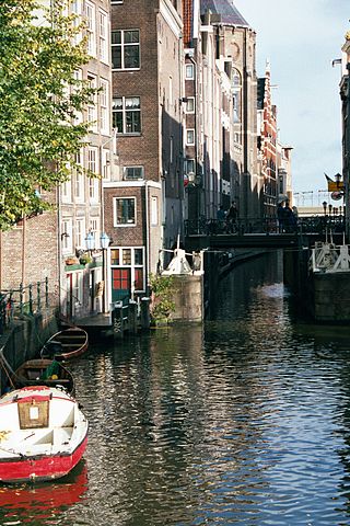
The Oudezijds Achterburgwal, often abbreviated to OZ Achterburgwal, is a street and canal in De Wallen, the red light district in the center of Amsterdam.
Just like the Oudezijds Voorburgwal, the OZ Achterburgwal runs from the Grimburgwal in the south to the Zeedijk in the north, where the canal changes into the Oudezijds Kolk, the outlet into the IJ .
North of the Korte Niezel / Korte Stormsteeg, which are connected by bridge 210, the houses on the east side are directly on the water of the Oudezijds Achterburgwal. They are the rear facades of the Zeedijk buildings, so there is no quay along this section.
The bridge over the Voorburgwal OZ between Oude Doelenstraat and Oude Hoogstraat (bridge 215) forms a dividing line between the noisy northern Wallendeel and the quiet southern part. The northern part is full of sex shops, window prostitution, peep shows, brothels, coffee shops and bars. The Hash, Marihuana & Hemp Museum is located on the northern part of the OZ Achterburgwal. The southern part includes University of Amsterdam buildings such as the Binnengasthuis and the Oudemanhuispoort.
History
The houses to the east of the Oudezijds Kolk on the Zeedijk have their rear walls directly on the water of the Oudezijds Achterburgwal.
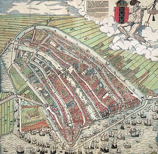
The Oudezijds Achterburgwal is part of the medieval city and once formed the eastern border of Amsterdam.
Until the end of the 14th century, the Amstel divided Amsterdam into two almost equal parts, the old side with the Old Church and the new side with the New Church. To protect the city, a moat was dug on each side with a burgwal behind it, an earthen wall, with a wooden palisade for protection. When new ramparts were constructed behind these ramparts around 1385, the existing rampart became the Voorburgwal and the new rampart became the Achterburgwal, both on the old and the new side. This is how Oudezijds Voorburgwal, Oudezijds Achterburgwal, Nieuwezijds Voorburgwal and Nieuwezijds Achterburgwal (now Spuistraat) were created. The Oudezijds Achterburgwal was dug in 1367. After a dyke breach in 1380, a new dyke was constructed behind the OZ Achterburgwal, the Sint Antoniesdijk (1387).[1]
Before the Alteratie (Alteration) in 1578 there were many monasteries in this neighborhood. There were 16 women's monasteries and three male monasteries in Amsterdam, most of them on Oudezijds Achterburgwal.[2] The names of many side streets of the Achterburgwal OZ still recall this past, such as the Bethaniënstraat and Monnikenstraat .
The Spinhuis, a women's prison for vagrants and beggars, was also on the OZ Achterburgwal.
The OZ Achterburgwal was refurbished in 2006 by the municipality of Amsterdam. The municipality announced in December 2007 that window prostitution in the Red Light District will be drastically reduced. Pub owner and landlord Charles Geerts was more or less forced to sell 51 of his "windows" on the OZ Achterburgwal to the municipality.[3] From January 7, 2008, 15 fashion subjects can live and work in the vacant buildings for a year. There will be a store at OZ Achterburgwal 121 where their designs will be sold.[4]
The number of windows on the OZ Achterburgwal will be further reduced in the context of the Project 1012 by purchasing more properties. The OZ Achterburgwal and side streets, however, is one of the few areas where window prostitution will not completely disappear.[5]
Some well-known structures on the OZ Achterburgwal are:
The Oudemanhuispoor, a covered passage between the OZ Achterburgwal and Kloveniersburgwal. A book market has been held in this for centuries . The Oudemanhuispoort complex is one of the main locations of the University of Amsterdam.
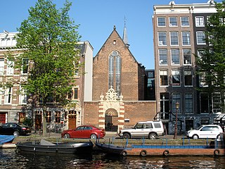
The Walloon Church, originally the chapel of the Paulusbroedersklooster. This chapel, consecrated in 1496, replaced an earlier chapel that was probably destroyed in the town fire of 1452.[6] The church is located on a small square, the Walenplein .
De Gecroonde Raep, a canal house on the Oudezijds Voorburgwal with the rear house on the Oudezijds Achterburgwal (number 46A).
The OZ Achterburgwal has more than 100 national monuments, including monument 8, the building in which the Bananenbar is located.
Bridges
Swans on the canal
There are a number of bridges across Oudezijds Achterburgwal (from north to south):
bridge 209, the Vredenburger bridge, between Vredenburgersteeg and Spooksteeg
bridge 210, between Korte Niezel and Korte Stormsteeg
bridge 211, between Oudekennissteeg and Molensteeg
bridge 214, Stoofbrug, leads from Stoofsteeg over the canal
bridge 215, Paulusbroedersluis, between Oude Doelenstraat and Oude Hoogstraat
bridge 216, somewhat skewed bridge between Sint Agnietenstraat and Rusland
From October 2015, an experimental bridge was started for this canal. The steel bridge was manufactured to a design by Joris Laarman from a 3D printer at a construction site on the NDSM wharf in Amsterdam-Noord. Work on the bridge started after the Amsterdam politician Kajsa Ollongren gave the go-ahead by cutting a ribbon. The bridge was supplied by a collaboration between Bouwbedrijf Heijmans NV and MX3D, a start-up company. At first it was thought that after a number of experiments the bridge could be printed on the spot, but that turned out to be a process that was not (yet) feasible. The insights had already partly changed in 2017, when it was hoped that the next bridge could be manufactured on site.[7][8][9] The bridge was completed in 2021.[10]
De Wallen or De Walletjes is the largest and best known red-light district in Amsterdam. It consists of a network of alleys containing approximately 300 one-room cabins rented by prostitutes who offer their sexual services from behind a window or glass door, typically illuminated with red lights and blacklight. Window prostitution is the most visible and typical kind of red-light district sex work in Amsterdam.
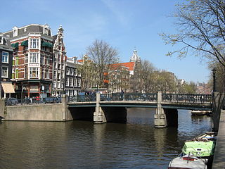
Amsterdam, capital of the Netherlands, has more than 100 kilometers (62 mi) of grachten (canals), about 90 islands and 1,500 bridges. The three main canals, dug in the 17th century during the Dutch Golden Age, form concentric belts around the city, known as the Grachtengordel. Alongside the main canals are 1550 monumental buildings. The 17th-century canal ring area, including the Prinsengracht, Keizersgracht, Herengracht and Jordaan, were listed as UNESCO World Heritage Site in 2010, contributing to Amsterdam's fame as the "Venice of the North".
The Oudekerksplein is a square in the centre of Amsterdam. It is named after the 14th-century church Oude Kerk which dominates the square. The Oudekerksplein is wedged between the Warmoesstraat street and Oudezijds Voorburgwal canal. From the square, the Oudekerksbrug bridge crosses the Oudezijds Voorburgwal canal and continues eastwards, through the Oudekennissteeg and Molensteeg alleys, towards the Oudezijds Achterburgwal and Zeedijk.
The Nieuwezijds Voorburgwal is a street in the centre of Amsterdam. The street runs north-south without intersecting major streets other than the intersection with Raadhuisstraat at its halfway point, right behind the Royal Palace. On the eastern side it has a number of alleys connecting to Kalverstraat and Nieuwendijk.
Hotel Die Port van Cleve is a historical 4-star hotel on the Nieuwezijds Voorburgwal in Amsterdam. The hotel is situated in the centre of Amsterdam, immediately north of the Magna Plaza shopping centre, and west of the Royal Palace on the Dam Square.
The Huis aan de Drie Grachten or Huis op de Drie Grachten is a 17th-century canal house in Amsterdam, at the southeastern end of the Wallen district. The name is a reference to the fact that the building faces three different Amsterdam canals. The south facade faces Grimburgwal, the west facade faces Oudezijds Voorburgwal and the east facade faces Oudezijds Achterburgwal. The address is Oudezijds Voorburgwal 249.
The walls of Amsterdam were built in the Middle Ages to protect the city against attack. The Medieval walls were replaced with a series of bastions in the 17th century. In the 19th century, the walls were torn down and replaced with the Defence Line of Amsterdam, a fortification line which encircled Amsterdam at a distance from the city.
Kloveniersburgwal is an Amsterdam canal flowing south from Nieuwmarkt to the Amstel River on the edge of the medieval city, lying east of the dam in the centre of Amsterdam.
The Walloon Church is a Protestant church building in Amsterdam, along the southern stretch of the Oudezijds Achterburgwal canal. The building dates to the late 15th century and has been in use as a Walloon church since 1586. The church was also known as the Franse Kerk, Walenkerk, Oude Walenkerk, or Oude Waalse Kerk.
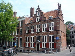
The Agnietenkapel is a 15th-century Gothic chapel in Amsterdam. It is the birthplace of the University of Amsterdam and still in use for doctoral dissertations and other university ceremonies, as well as academic events such as lectures and symposiums. The building has held rijksmonument status since 1970.
The Oudezijds Voorburgwal, often abbreviated to OZ Voorburgwal, is a street and canal in De Wallen in the center of Amsterdam. The OZ Voorburgwal runs from the Grimburgwal in the south to the Zeedijk in the north, where it changes into the Oudezijds Kolk, which drains into the IJ.
The Grimburgwal is a small canal and street in the center of Amsterdam.
The Oudezijds Kolk is a short and narrow canal/lock in Amsterdam between the Oudezijds Voorburgwal and the Oosterdok.
The Geldersekade is a canal and a street in Amsterdam that connects the Nieuwmarkt with the Prins Hendrikkade. The Geldersekade is in the easternmost part of De Wallen, the red light district, and borders Chinatown.
The Oudeschans, or Oude Schans, originally the Nieuwe Gracht, is a wide canal in the eastern part of the inner city of Amsterdam.
Martelaarsgracht is a street and former canal in Amsterdam, the Netherlands.
The Spuistraat in downtown Amsterdam connects the Hekelveld to the Spui. It runs roughly north to south, parallel to the Singel and the Nieuwezijds Voorburgwal. At the Royal Palace of Amsterdam, the Spuistraat crosses the Raadhuisstraat and Paleisstraat. Originally the Spuistraat was a canal, the Nieuwezijds Achterburgwal. The canal was filled in in 1867, and the street renamed then.
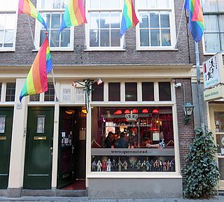
The Queen's Head is a gay bar located at Zeedijk 20 in the centre of Amsterdam. It opened in 1998 and is known for its drag queen bingo evenings.
This page is based on this Wikipedia article Text is available under the CC BY-SA 4.0 license; additional terms may apply. Images, videos and audio are available under their respective licenses.