Lastage is a neighborhood in the Centrum borough of Amsterdam, Netherlands. It is located between the Geldersekade and Oudeschans canals, just east of old medieval city. Today, the neighbourhood is also known as Nieuwmarktbuurt due to the fact that the Nieuwmarkt is comprised in the area; it is protected as a heritage site.
Uilenburg is a neighborhood of Amsterdam, Netherlands.

Oudeschans is a small village with a population of around 100 in the municipality of Westerwolde in the province of Groningen in the Netherlands. The 16th-century fortification is now a state protected village area with several national heritage sites, among which a 17th-century garrison church, and the Vestingmuseum Oudeschans.
The Nieuwe Herengracht is a canal in Centrum district of Amsterdam. The canal is an extension of the Herengracht that runs between the Amstel and the Scharrebiersluis (lock) leading to the Schippersgracht from the Entrepotdok. It is in the Plantage neighborhood in the eastern part of the Grachtengordel.

The Oudezijds Kolk is a short and narrow canal/lock in Amsterdam between the Oudezijds Voorburgwal and the Oosterdok.

The Nieuwe Vaart or Nieuwevaart is a 17th-century canal in Amsterdam that runs from the center to Amsterdam-Oost.
The Kromme Waal is a street in Amsterdam between the Prins Hendrikkade and the Oude Waal. From Kraansluis to Waalseilandbrug, the street forms the western quay of the Waalseilandsgracht, the old inner harbor of Amsterdam between the Montelbaanstoren and the IJ.

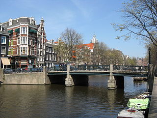
The Blauwburgwal is a canal in Amsterdam between the Singel and the Herengracht. It is the shortest canal in the city center and part of the west Grachtengordel.
The Rechtboomssloot, or Recht Boomssloot, is a canal in the Lastage (Nieuwmarktbuurt) neighborhood in the center of Amsterdam.

The Kromboomssloot, or Krom Boomssloot, is a canal in the Lastage (Nieuwmarktbuurt) neighborhood in the center of Amsterdam. It provides a transverse navigation from the Rechtboomssloot and was previously called Dwarsboomssloot. As the names indicate, the Rechtboomssloot is completely straight, while there is a curve in the Kromboomssloot.
The Geldersekade is a canal and a street in Amsterdam that connects the Nieuwmarkt with the Prins Hendrikkade. The Geldersekade is in the easternmost part of De Wallen, the red light district, and borders Chinatown.

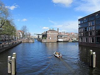
The Oudeschans, or Oude Schans, originally the Nieuwe Gracht, is a wide canal in the eastern part of the inner city of Amsterdam.

The Houtkopersburgwal is a short secondary canal in Amsterdam. It is located in the east of the Amsterdam-Centrum district in the Lastage neighborhood.
The Uilenburgergracht is a secondary canal in Amsterdam, the Netherlands. It is located east of the Amsterdam-Centrum district, in the Lastage neighborhood.

The Rapenburgwal is a secondary canal in Amsterdam in the east of the Amsterdam-Centrum district, in the Lastage neighborhood.

The Snoekjesgracht is a small canal in Amsterdam, in the Lastage neighborhood.
The Eilandsgracht is a canal in Amsterdam between the Westelijke Eilanden and the mainland. It originally ran between the mainland and two of the islands, Prinseneiland and Bickerseiland. In 1928 the section along Bickerseiland was filled in.
The Prinseneilandsgracht is a canal in the Centrum district of Amsterdam. It runs between Prinseneiland, an artificial island, to the east and the mainland to the west. Until after World War II (1939–45) the canal was bordered almost exclusively by warehouses and factories.

Prins Hendrikkade is a major street in the centre of Amsterdam. It passes Amsterdam Central Station, intersects the Damrak at the mouth of the Amstel river, and forms the southern end of the IJtunnel across the IJ bay. The street was named after Prince Henry of the Netherlands, youngest son of King William II, following Henry's death in 1879.
This page is based on this
Wikipedia article Text is available under the
CC BY-SA 4.0 license; additional terms may apply.
Images, videos and audio are available under their respective licenses.


