Location
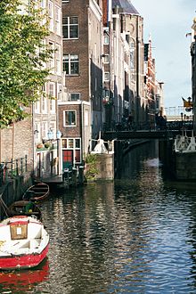
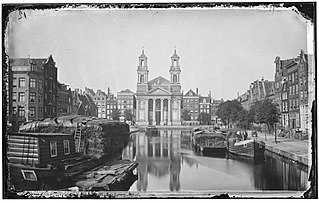
The Oudezijds Kolk runs north from the junction of the Oudezijds Voorburgwal and Oudezijds Achterburgwal under the Zeedijk to the Open Havenfront, which connects to (the IJ) It is connected to the Geldersekade where it runs under the Prins Hendrikkade in the north. Via the Kolksluis (bridge 302), built at the beginning of the 15th century, it served as a drainage ditch to the IJ, now the Open Havenfront. The canal is connected to the Open Haven front via the Kolkswaterkering (bridge 301). The Oudezijds Kolk, often abbreviated to: OZ Kolk, has traditionally been called "Het Kolkje".
The Kolksluis (Kolk Sluice) has been operating since the Middle Ages. The Kolksluis, the lock, was in a vault of the Oudezijds Kolk. That was demolished in 1702 and replaced by the present bridge. During high tide, the lock is closed to protect flooding. The river Amstel continues to flow into the canals to the south, raising their level. When the tide drops, the lock is opened and the waters flow out to the sea. Through this spuien (sluicing) process the canal waters are kept fresh.
There is only one quay, on the southeast side, which is only for pedestrians. On the northwest side the buildings back directly onto the canal including the Basilica of Saint Nicholas, formerly St. Nicholas inside the Walls, and what was once a paint factory. There are several warehouses from the 17th and 18th centuries. The national monument Oudezijds Kolk 5, “Het wijnpakhuis Malaga” (Malaga wine warehouse), was built in 1617. It now holds privately owned apartments. The France Hotel Amsterdam is at Oudezijds Kolk 11.

The Amstel is a river in the province of North Holland in the Netherlands. It flows from the Aarkanaal and Drecht in Nieuwveen northwards, passing Uithoorn, Amstelveen, and Ouderkerk aan de Amstel, to the IJ in Amsterdam. Annually, the river is the location of the Liberation Day concert, Head of the River Amstel rowing match, and the Amsterdam Gay Pride boat parade.

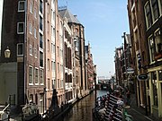
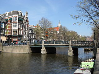
Amsterdam, capital of the Netherlands, has more than 100 kilometers (62 mi) of grachten (canals), about 90 islands and 1,500 bridges. The three main canals, dug in the 17th century during the Dutch Golden Age, form concentric belts around the city, known as the Grachtengordel. Alongside the main canals are 1550 monumental buildings. The 17th-century canal ring area, including the Prinsengracht, Keizersgracht, Herengracht and Jordaan, were listed as UNESCO World Heritage Site in 2010, contributing to Amsterdam's fame as the "Venice of the North".

NH Collection Grand Hotel Krasnapolsky, often informally referred to as Kras is a five-star hotel on Dam Square in central Amsterdam, Netherlands, founded in 1865. The hotel has 451 rooms, a convention center, restaurants and a pier for boats on the Oudezijds Voorburgwal canal.

Westelijke Eilanden are three islands in the Centrum district of Amsterdam: Bickerseiland, Prinseneiland and Realeneiland. They are located to the south of the IJ and the Zeeheldenbuurt, to the north of the railway line between Central Station and Amsterdam-Sloterdijk, to the west of the Westerdok and to the east of the Planciusbuurt on the Westerkanaal. The Westelijke Eilanden form the core of the Golden Reael area, which also includes the adjacent Westerdok island, the Haarlemmerbuurt and the Planciusbuurt.
The Huis aan de Drie Grachten or Huis op de Drie Grachten is a 17th-century canal house in Amsterdam, at the southeastern end of the Wallen district. The name is a reference to the fact that the building faces three different Amsterdam canals. The south facade faces Grimburgwal, the west facade faces Oudezijds Voorburgwal and the east facade faces Oudezijds Achterburgwal. The address is Oudezijds Voorburgwal 249.
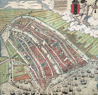
The walls of Amsterdam were built in the Middle Ages to protect the city against attack. The Medieval walls were replaced with a series of bastions in the 17th century. In the 19th century, the walls were torn down and replaced with the Defence Line of Amsterdam, a fortification line which encircled Amsterdam at a distance from the city.

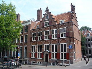
The Stadsbank van Lening is a not-for-profit city Bank van Lening dating from 1614 on the Oudezijds Voorburgwal in Amsterdam, Netherlands. It is the oldest credit distributor in Amsterdam and today has about 85 employees working here and in offices on the Albert Cuypstraat, Bijlmerplein and Osdorpplein.

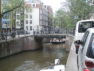
The Oudezijds Voorburgwal, often abbreviated to OZ Voorburgwal, is a street and canal in De Wallen in the center of Amsterdam. The OZ Voorburgwal runs from the Grimburgwal in the south to the Zeedijk in the north, where it changes into the Oudezijds Kolk, which drains into the IJ.

The Grimburgwal is a small canal and street in the center of Amsterdam.
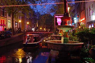
The Oudezijds Achterburgwal, often abbreviated to OZ Achterburgwal, is a street and canal in De Wallen, the red light district in the center of Amsterdam.
The Rechtboomssloot, or Recht Boomssloot, is a canal in the Lastage (Nieuwmarktbuurt) neighborhood in the center of Amsterdam.
The Geldersekade is a canal and a street in Amsterdam that connects the Nieuwmarkt with the Prins Hendrikkade. The Geldersekade is in the easternmost part of De Wallen, the red light district, and borders Chinatown.
Martelaarsgracht is a street and former canal in Amsterdam, the Netherlands.
The Leprozengracht was a canal in Amsterdam that defined one side of the Vlooyenburg island. Leprozengracht and the connected Houtgracht canal were filled in 1882 to form the Waterlooplein.

The Houtgracht was a canal in Amsterdam that defined one side of Vlooyenburg island. Houtgracht and the connected Leprozengracht canal were filled in 1882 to form the Waterlooplein.

The Nieuwezijds Achterburgwal is a former street and canal in Amsterdam, the Netherlands. From around 1380 to 1450 it was part of the town's defenses. The canal was filled in in 1866, and is now Spuistraat.

The Spuistraat in downtown Amsterdam connects the Hekelveld to the Spui. It runs roughly north to south, parallel to the Singel and the Nieuwezijds Voorburgwal. At the Royal Palace of Amsterdam, the Spuistraat crosses the Raadhuisstraat and Paleisstraat. Originally the Spuistraat was a canal, the Nieuwezijds Achterburgwal. The canal was filled in in 1867, and the street renamed then.

Prins Hendrikkade is a major street in the centre of Amsterdam. It passes Amsterdam Central Station, intersects the Damrak at the mouth of the Amstel river, and forms the southern end of the IJtunnel across the IJ bay. The street was named after Prince Henry of the Netherlands, youngest son of King William II, following Henry's death in 1879.