Kromboomssloot

Last updated
Kromboomssloot
Kromboomssloot.jpg
The Kromboomssloot, looking north towards the bend that makes the canal crooked.
Amsterdam centre map.png
Red pog.svg
Location Amsterdam
Postal code1011
Coordinates 52°22′17″N4°54′08″E / 52.371389°N 4.902222°E / 52.371389; 4.902222
East end Rechtboomssloot
To Snoekjesgracht
The Kromboomssloot at the bottom left on the map by Cornelis Anthonisz. (1544) De Groote Kaart van Amsterdam in 1544 (The Big Map of Amsterdam in 1544) by Cornelis Anthonisz.jpg
The Kromboomssloot at the bottom left on the map by Cornelis Anthonisz. (1544)

The Kromboomssloot, or Krom Boomssloot, is a canal in the Lastage (Nieuwmarktbuurt) neighborhood in the center of Amsterdam. It provides a transverse navigation from the Rechtboomssloot and was previously called Dwarsboomssloot. As the names indicate, the Rechtboomssloot (Straight Boom Ditch) is completely straight, while there is a curve in the Kromboomssloot (Crooked Boom Ditch).

Contents

The canal was chosen in 2007 as one of the most beautiful streets in Amsterdam. [1]

Description

Levensboom (Tree of Life) by Wim Tap Levensboom Wim Tap.jpg
Levensboom (Tree of Life) by Wim Tap

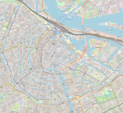
The Kromboomssloot runs from the Rechtboomssloot in a southwestern direction to a bend where the canal changes into the Snoekjesgracht and leads to the Oudeschans canal. At this bend there is a square with benches and a pillar-shaped artwork by Wim Tap from 1989.

The canal has four bridges: bridge no. 295 at the corner with the Rechtboomssloot, bridge no. 292 between Koningsstraat and Korte Koningsstraat, bridge no. 293 between Keizersstraat and Korte Keizersstraat and bridge no. 290 between Dijkstraat and Korte Dijkstraat.

History

The Kromboomssloot is about five centuries old. The canal is named after the 16th-century landowner and shipbuilder Cornelis Boom. Both the Kromboomssloot and Rechtboomssloot were originally ditches that were commissioned by Cornelis Boom to be widened into canals to connect his shipyard on the Lastage with the IJ.

In 1994 the municipality proposed a plan to dig up the trees on the Kromboomssloot and Rechtboomssloot. However, this plan was canceled after protests by residents. [2]

Famous buildings

Schottenburch

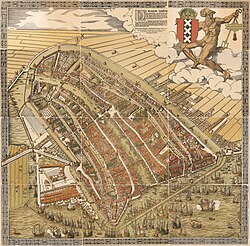
Schottenburch is said to be the oldest existing warehouse in Amsterdam. It is certainly one of the oldest warehouses in the city. Schottenburch has a gable stone with the date 1636, but the building can already be seen on the city map of Amsterdam from 1595 made by Pieter Bast. It is a double warehouse with spout facades and shutters at Kromboomssloot 18–20. Pakhuis de Schottenburch was an artists' initiative from 1979 to 1988. Exhibitions, performances, theater, art events (including "Closer to the Images" and "Art or Pornography?") and music performances were organized by visual artist Wim Vonk, who organized the Schottenburch artists' initiative.

Schottenburch now houses residences, a gallery and a wine trader. [3]

Armenian Apostolic Church

The Armenian-Apostolic Church opened its doors in a former warehouse on the Kromboomssloot in 1714. In 1749 the church was expanded and embellished with, among other things, a frame around the outside door. The church remained in use until 1806. The building was sold in 1874, but in 1989, following the arrival of a new wave of believers from, among others, Turkey, it was bought back and re-used as a church building. In August 2008 a renovation started that would last two years. The upper floors are likely to have a cultural or museum destination. [4] [5] [6]

De Oude Jumbo

De Oude Jumbo is a complex of five contiguous buildings on Kromboomssloot and Oudeschans, four of which (two from the 17th century and two from the 18th century) have been designated as national monuments. In this complex, game manufacturer Jumbo developed well-known games such as Stratego. In 2006, Jumbo left the five buildings and moved to Zaandam. After this, the complex was converted into apartments, whereby the densely built up inner gardens were opened up again and the original rear facades were restored. [7]

De Branderij

The Branderij, the former coffee roasting factory of Alex Meijer & Co., was designed in the early 20th century by architect Emanuel Marcus Rood (1851-1929). The sober art nouveau style building is now a municipal monument. [8]

See also

Notes

    1. "Amsterdams mooiste straat: Bos weer bij de verliezers", Het Parool, 18 mei 2007
    2. "Hetzelfde en toch anders, Opnieuw
    3. "Een verdedigende wandeling", Jordaanweb.nl
    4. Willem Frijhoff en Maarten Prak (red.), Geschiedenis van Amsterdam: Centrum van de wereld 1578-1650, Amsterdam 2004, p. 425
    5. Oude Kerk Amsterdam
    6. "Trekvogel bouwt altijd beste nest", Volkskrant.nl
    7. Kunstbus
    8. "Ymere". Archived from the original on 2014-11-29. Retrieved 2019-07-23.

    Sources

    Related Research Articles

    <span class="mw-page-title-main">Gouda, South Holland</span> City and municipality in South Holland, Netherlands

    Gouda is a city and municipality in the west of the Netherlands, between Rotterdam and Utrecht, in the province of South Holland. Gouda has a population of 75,000 and is famous for its Gouda cheese, stroopwafels, many grachten, smoking pipes, and its 15th-century city hall. Its array of historic churches and other buildings makes it a very popular day trip destination.

    <span class="mw-page-title-main">Oude Kerk, Amsterdam</span>

    The Oude Kerk is Amsterdam’s oldest building and newest art institute. The building was founded about 1213 and consecrated in 1306 by the bishop of Utrecht with Saint Nicolas as its patron saint. After the Reformation in 1578, it became a Calvinist church, which it remains today. It stands in De Wallen, now Amsterdam's main red-light district. The square surrounding the church is the Oudekerksplein.

    <span class="mw-page-title-main">Singel</span> Street and canal in Amsterdam

    The Singel is one of the canals of Amsterdam. The Singel encircled Amsterdam in the Middle Ages, serving as a moat around the city until 1585, when Amsterdam expanded beyond the Singel. The canal runs from the IJ bay, near the Central Station, to the Muntplein square, where it meets the Amstel river. It is now the inner-most canal in Amsterdam's semicircular ring of canals.

    <span class="mw-page-title-main">Sint Antoniesbreestraat</span> Street in Amsterdam

    The Sint Antoniesbreestraat is a street in the centre of Amsterdam in the Netherlands. The street runs south from Nieuwmarkt square to the Sint Antoniesluis sluice gates, where it continues as the Jodenbreestraat. The Sint Antoniesbreestraat is primarily a shopping street with a variety of specialty shops. At the corner of Sint Antoniesbreestraat and Hoogstraat is an entry to the Nieuwmarkt stop of the Amsterdam Metro system.

    <span class="mw-page-title-main">Canals of Amsterdam</span> Grachten dug in the 17th century during the Dutch Golden Age; UNESCO World Heritage Site

    Amsterdam, capital of the Netherlands, has more than 100 kilometers (62 mi) of grachten (canals), about 90 islands and 1,500 bridges. The three main canals, dug in the 17th century during the Dutch Golden Age, form concentric belts around the city, known as the Grachtengordel. Alongside the main canals are 1550 monumental buildings. The 17th-century canal ring area, including the Prinsengracht, Keizersgracht, Herengracht and Jordaan, were listed as UNESCO World Heritage Site in 2010, contributing to Amsterdam's fame as the "Venice of the North".

    <span class="mw-page-title-main">Oost-Indisch Huis</span> Building in Kloveniersburgwal , CX Amsterdam

    The Oost-Indisch Huis is an early 17th-century building in the centre of Amsterdam. It was the headquarters of the Amsterdam chamber of the Dutch East India Company. It is a listed Dutch national heritage site (rijksmonument).

    <span class="mw-page-title-main">Lastage</span> Neighbourhood of Amsterdam in North Holland, Netherlands

    Lastage is a neighborhood in the Centrum borough of Amsterdam, Netherlands. It is located between the Geldersekade and Oudeschans canals, just east of old medieval city. Today, the neighbourhood is also known as Nieuwmarktbuurt due to the fact that the Nieuwmarkt is comprised in the area; it is protected as a heritage site.

    <span class="mw-page-title-main">Nieuwe Herengracht</span> Canal in Amsterdam

    The Nieuwe Herengracht is a canal in Centrum district of Amsterdam. The canal is an extension of the Herengracht that runs between the Amstel and the Scharrebiersluis (lock) leading to the Schippersgracht from the Entrepotdok. It is in the Plantage neighborhood in the eastern part of the Grachtengordel.

    <span class="mw-page-title-main">Oudezijds Voorburgwal</span> Canal in Amsterdam

    The Oudezijds Voorburgwal, often abbreviated to OZ Voorburgwal, is a street and canal in De Wallen in the center of Amsterdam. It runs from the Grimburgwal in the south to the Zeedijk in the north, where it changes into the Oudezijds Kolk, which drains into the IJ.

    <span class="mw-page-title-main">Oudezijds Achterburgwal</span> Canal in Amsterdam

    The Oudezijds Achterburgwal, often abbreviated to OZ Achterburgwal, is a street and canal in De Wallen, the red light district in the center of Amsterdam.

    <span class="mw-page-title-main">Entrepotdok</span> Canal in Amsterdam

    The Entrepotdok, formerly Nieuwe Rapenburgergracht, is a canal in Amsterdam, and a street and row of former warehouses with the same name along the northeast side of the canal. They were constructed between 1708 and 1829, used for storage, squatted in the 1990s and are now converted into apartments. Entrepotdok is the largest inhabited warehouse complex in Amsterdam. The canal runs between the Kadijksplein and Sarphatistraat, and is parallel to Hoogte Kadijk, Laagte Kadijk, Plantage Doklaan and Natura Artis Magistra zoo.

    <span class="mw-page-title-main">Rechtboomssloot</span> Canal in Amsterdam

    The Rechtboomssloot, or Recht Boomssloot, is a canal in the Lastage (Nieuwmarktbuurt) neighborhood in the center of Amsterdam.

    <span class="mw-page-title-main">Cornelis Boom</span> Dutch landowner and shipbuilder

    Cornelis Pietersz. Boom was a Dutch landowner and shipbuilder who was involved in various disputes over opening up the Lastage area to the east of Amsterdam. His two sons and one grandson were mayors of Amsterdam.

    <span class="mw-page-title-main">Geldersekade</span> Canal in Amsterdam

    The Geldersekade is a canal and a street in Amsterdam that connects the Nieuwmarkt with the Prins Hendrikkade. The Geldersekade is in the easternmost part of De Wallen, the red light district, and borders Chinatown.

    <span class="mw-page-title-main">Oudeschans, Amsterdam</span> Canal in Amsterdam

    The Oudeschans, or Oude Schans, originally the Nieuwe Gracht, is a wide canal in the eastern part of the inner city of Amsterdam.

    <span class="mw-page-title-main">Houtkopersburgwal</span> Canal in Amsterdam

    The Houtkopersburgwal is a short secondary canal in Amsterdam. It is located in the east of the Amsterdam-Centrum district in the Lastage neighborhood.

    <span class="mw-page-title-main">Uilenburgergracht</span> Canal in Amsterdam

    The Uilenburgergracht is a secondary canal in Amsterdam, the Netherlands. It is located east of the Amsterdam-Centrum district, in the Lastage neighborhood.

    <span class="mw-page-title-main">Snoekjesgracht</span> Canal in Amsterdam

    The Snoekjesgracht is a small canal in Amsterdam, in the Lastage neighborhood.

    <span class="mw-page-title-main">Waalseilandsgracht</span> Canal in Amsterdam

    The Waalseilandsgracht, or Waalseilandgracht, is a short, wide canal in the east part of the inner city of Amsterdam.

    <span class="mw-page-title-main">Spuistraat</span> Former canal, now street, in Amsterdam

    The Spuistraat in downtown Amsterdam connects the Hekelveld to the Spui. It runs roughly north to south, parallel to the Singel and the Nieuwezijds Voorburgwal. At the Royal Palace of Amsterdam, the Spuistraat crosses the Raadhuisstraat and Paleisstraat. Originally the Spuistraat was a canal, the Nieuwezijds Achterburgwal. The canal was filled in in 1867, and the street renamed then.