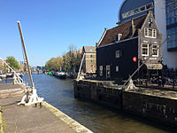
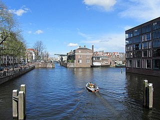
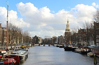
The Oudeschans canal continues the line of the Zwanenburgwal, to which it is connected by the Sint Antoniesluis, a lock that is crossed by the bridge where Sint Antoniesbreestraat turns into Jodenbreestraat. It runs northeast to the Oosterdok, which in turn is connected to the IJ. The 16th-century Montelbaanstoren is on the canal, which is sometimes called the Montelbaansgracht. The canal forms the western shore of the city island of Uilenburg on the border of the Lastage neighborhood .
The quays on either side of the canal are called Oudeschans, with the exception of the section between the Waalseilandgracht and the Oosterdok at the Prins Hendrikkade. There, the northeastern quay is called the Kalkmarkt and the opposite quay is called 's-Gravenhekje. Next to house number 10 there is a "corridor" to a back area on which the De Waag Playground is located. The artist Su Tomesen designed a gateway for this. The Snoekjesgracht, Rechtboomssloot and Waalseilandgracht open into the Oudeschans from the northwest. The Houtkopersburgwal and Rapenburgwal open into it from the southeast.
The odd-numbered southeast side of the Oudeschans lies on the island of Uilenburg, which can only be reached via three bridges:
From the direction of Nieuwmarkt via Keizersbrug (bridge no. 286) at Korte Koningsstraat.
From the direction of Jodenbreestraat via Steenvoetsluis (bridge 291) at the Nieuwe Uilenburgerstraat / Houtkopersburgwal,
From the direction of Prins Hendrikkade / Rapenburg via the Peperbrug (bridge 281) at the Nieuwe Uilenburgerstraat / Peperstraat.
The Montelbaansbrug (bridge no. 280) is an extension of the even-numbered side of the Oudeschans over the Waalseilandsgracht at the Oude Waal and the Binnenkant. The Kikkerbilssluis (bridge no. 279) spans the water of the Oudeschans at the Prins Hendrikkade.
History
The Lastage between the Oudeschans (left) and Geldersekade. Detail of a woodcut by Cornelis Anthonisz. from 1544.The Oudeschans (bottom right of the center) has become part of the city. On the right the Lastage; on the left the islands of Uilenburg and Valkenburg. Detail of van Berckenrode map from 1625.
In 1512, troops from Guelders attacked the city and plundered the Lastage, the industrial area with shipyards on the eastern side outside the city. Between 1515 and 1518 an armof the Amstel was dug out, the Zwanenburgwal, leading to the Nieuwe Gracht, as the Oudeschans was then called. This became the defensive moat for the east side of the city. A defensive wall was thrown up with the earth dug out, on which a wooden palisade was erected. The Montelbaan tower was built in 1516 as part of this defensive work.
At the end of the 16th century, during the Second Expansion, three islands southeast of the Nieuwe Gracht were included: Uilenburg, Marken (later called Valkenburg ) and Rapenburg. When a new city wall was erected to defend against the Spanish, it included the new islands. The Nieuwe Gracht and the old redoubt lost its defensive function.
In 1602 a channel was cut through the Sint Antoniesdijk on the south side of the Oudeschans, and the Sint Antoniesluis (a lock) was built so that ships could sail to the Amstel via the Zwanenburgwal.
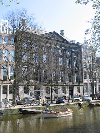
The West-Indian warehouse is on the 's-Gravenhekje, where the Oudeschans flows into the Oosterdok. This monumental complex, built in 1642, was the headquarters of the Dutch West India Company between 1646 and 1674.
In 1833, after a rumor that ghosts had been seen, the Oudeschans was nicknamed the ghost quay.
The Oudeschans and the parallel Nieuwe Uilenburgerstraat, were located in the heart of the old Jodenbuurt (Jewish neighborhood) of Amsterdam.
In 1927 the municipality built a block of 72 homes in the style of the late Amsterdam School in collaboration with the Bouwfonds Handwerkers Vriendenkring. The block was designed by Jan Hendrik Mulder Jr. (1888–1960) and built on the Oudeschans / Nieuwe Uilenburgerstraat. The ground floor areas, with the monumental natural stone entrance at Oudeschans 21, were originally designed as storage for the goods, stalls and carts of the Jewish street market on Nieuwe Uilenburgerstraat, which was popular before World War II. The complex is used as an exhibition and studio space, and offers space for artists and young entrepreneurs.
The Korendrager warehouse on Oudeschans 73-77 was destroyed by fire in 1949. Between 1974 and 2004, the Bimhuis stood here. When this concert hall for jazz and improvised music had found a new home in the Muziekgebouw aan 't IJ, an apartment building was built on the site in 2007 based on a design by Tekton architects.
Notable residents
Jan Swammerdam lived at Oudeschans 18, where his father, who was known for his natural history collection, had a pharmacy .
Between 1887 and 1888, the painter Willem Witsen rented the studio in Oudeschans 5 formerly used by George Hendrik Breitner. The Montelbaanstoren and Oudeschans were a favorite subject that he drew and painted from his window.
The West-Indian warehouse, Oudeschans, on the left the Oosterdok. Engraving 1655.
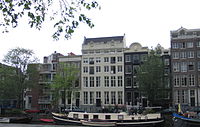
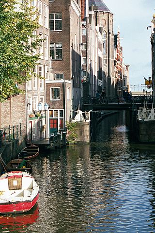
The Zwanenburgwal is a canal and street in the center of Amsterdam. During the Dutch Golden Age the canal was home to painter Rembrandt van Rijn, as well as philosopher Spinoza lived here. In 2006 it was voted one of the most beautiful streets in Amsterdam by readers of Het Parool, a local daily newspaper.
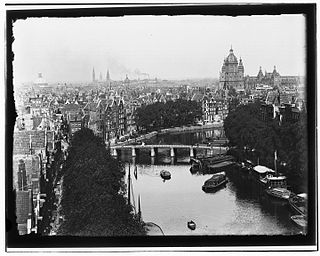
Amsterdam, capital of the Netherlands, has more than 100 kilometers (62 mi) of grachten (canals), about 90 islands and 1,500 bridges. The three main canals, dug in the 17th century during the Dutch Golden Age, form concentric belts around the city, known as the Grachtengordel. Alongside the main canals are 1550 monumental buildings. The 17th-century canal ring area, including the Prinsengracht, Keizersgracht, Herengracht and Jordaan, were listed as UNESCO World Heritage Site in 2010, contributing to Amsterdam's fame as the "Venice of the North".
The Jodenbuurt is a neighbourhood of Amsterdam, Netherlands. For centuries before World War II, it was the center of the Dutch Jews of Amsterdam — hence, its name. It is best known as the birthplace of Baruch Spinoza, the home of Rembrandt, and the Jewish ghetto of Nazi occupation of the Netherlands.
Lastage is a neighborhood in the Centrum borough of Amsterdam, Netherlands. It is located between the Geldersekade and Oudeschans canals, just east of old medieval city. Today, the neighbourhood is also known as Nieuwmarktbuurt due to the fact that the Nieuwmarkt is comprised in the area; it is protected as a heritage site.
The walls of Amsterdam were built in the Middle Ages to protect the city against attack. The Medieval walls were replaced with a series of bastions in the 17th century. In the 19th century, the walls were torn down and replaced with the Defence Line of Amsterdam, a fortification line which encircled Amsterdam at a distance from the city.
Kloveniersburgwal is an Amsterdam canal flowing south from Nieuwmarkt to the Amstel River on the edge of the medieval city, lying east of the dam in the centre of Amsterdam.
The Nieuwe Herengracht is a canal in Centrum district of Amsterdam. The canal is an extension of the Herengracht that runs between the Amstel and the Scharrebiersluis (lock) leading to the Schippersgracht from the Entrepotdok. It is in the Plantage neighborhood in the eastern part of the Grachtengordel.
The Oudezijds Kolk is a short and narrow canal/lock in Amsterdam between the Oudezijds Voorburgwal and the Oosterdok.
The Kromme Waal is a street in Amsterdam between the Prins Hendrikkade and the Oude Waal. From Kraansluis to Waalseilandbrug, the street forms the western quay of the Waalseilandsgracht, the old inner harbor of Amsterdam between the Montelbaanstoren and the IJ.
The Kromboomssloot, or Krom Boomssloot, is a canal in the Lastage (Nieuwmarktbuurt) neighborhood in the center of Amsterdam. It provides a transverse navigation from the Rechtboomssloot and was previously called Dwarsboomssloot. As the names indicate, the Rechtboomssloot is completely straight, while there is a curve in the Kromboomssloot.
The Geldersekade is a canal and a street in Amsterdam that connects the Nieuwmarkt with the Prins Hendrikkade. The Geldersekade is in the easternmost part of De Wallen, the red light district, and borders Chinatown.
The Houtkopersburgwal is a short secondary canal in Amsterdam. It is located in the east of the Amsterdam-Centrum district in the Lastage neighborhood.
The Uilenburgergracht is a secondary canal in Amsterdam, the Netherlands. It is located east of the Amsterdam-Centrum district, in the Lastage neighborhood.
The Rapenburgwal is a secondary canal in Amsterdam in the east of the Amsterdam-Centrum district, in the Lastage neighborhood.
The Snoekjesgracht is a small canal in Amsterdam, in the Lastage neighborhood.
The Waalseilandsgracht, or Waalseilandgracht, is a short, wide canal in the east part of the inner city of Amsterdam.
Martelaarsgracht is a street and former canal in Amsterdam, the Netherlands.
The Houtgracht was a canal in Amsterdam that defined one side of Vlooyenburg island. Houtgracht and the connected Leprozengracht canal were filled in 1882 to form the Waterlooplein.
Prins Hendrikkade is a major street in the centre of Amsterdam. It passes Amsterdam Central Station, intersects the Damrak at the mouth of the Amstel river, and forms the southern end of the IJtunnel across the IJ bay. The street formed the northern edge and outer harbour of the city until the 19th century. It was named after Prince Henry of the Netherlands, youngest son of King William II, following Henry's death in 1879.
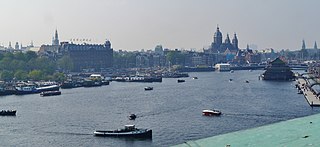
The Oosterdok is a former wet dock in Amsterdam. It was created in 1831-1832 by constructing the Oosterdoksdam and the Oosterdoksluis, forming a reliable deep port closed off from the tidal IJ.
This page is based on this Wikipedia article Text is available under the CC BY-SA 4.0 license; additional terms may apply. Images, videos and audio are available under their respective licenses.