Trams
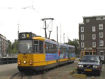
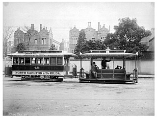
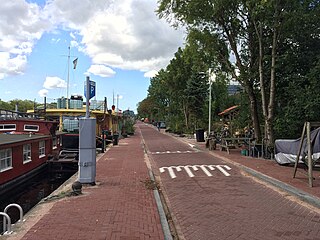
From 1900 to 1942 tram line 10 had its end point at the end of the Planciusstraat at the Zoutkeetsgracht. In 1907 the circuit was brought into use via Zoutkeetsgracht - Houtmankade - Eerste Breeuwersstraat. Line 19 also had its end point here between 1923 and 1944 Line 10 was moved to Van Hallstraat in 1942. Since 1951, line 3 has its end point here.
In 2000, the municipality decided to name the piece of quay along Zoutkeetsgracht 211 to 221, where the tram has its terminus, as Korte Zoutkeetsgracht. This has cleared up a lot of confusion among postmen, visitors and buyers. [1] As a result, the tram stop is no longer in the street whose name it bears. This is the only tram end point in Amsterdam on a canal.
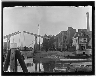
After the fire of the 'Holland' bread factory. In the foreground is bridge no. 317 ('Petemayen bridge') between Zandhoek (left) and Bokkinghang (right).
Jacob Olie 1894
Tram line 3 at the Zoutkeetsgracht terminus, just visible on the left.
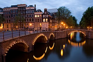
Zoutkeetsgracht and Barenstzstraat

Jacob Olie was a photographer from Amsterdam known for his scenes of everyday life there.

The Hudson River is a 315-mile (507 km) river that flows from north to south primarily through eastern New York in the United States. The river originates in the Adirondack Mountains of Upstate New York, flows southward through the Hudson Valley to the Upper New York Bay between New York City and Jersey City. It eventually drains into the Atlantic Ocean at New York Harbor. The river serves as a political boundary between the states of New Jersey and New York at its southern end. Further north, it marks local boundaries between several New York counties. The lower half of the river is a tidal estuary, deeper than the body of water into which it flows, occupying the Hudson Fjord, an inlet which formed during the most recent period of North American glaciation, estimated at 26,000 to 13,300 years ago. Tidal waters influence the Hudson's flow from as far north as the city of Troy.

Amstelveen is a municipality in the province of North Holland, Netherlands with a population of 89,918 (2017). It is a suburban part of the metropolitan area of Amsterdam.
The Melbourne cable tramway system was a cable car public transport system, which operated between 1885 and 1940 in Melbourne, Victoria, Australia.
Halfweg is a town in the Dutch province of North Holland. Previously a part of the municipality of Haarlemmerliede en Spaarnwoude, it is currently a part of the municipality of Haarlemmermeer and lies about 8 km (5.0 mi) east of Haarlem. Its name, which translates as "halfway," comes from its location approximately halfway between Haarlem and Amsterdam.
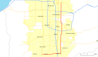
State Route 71 (SR-71) is a state highway completely within the Salt Lake City metropolitan area in the northern portion of the US state of Utah. It runs from SR-154 in the southwest side of the city to SR-186 in Downtown Salt Lake City. The route spans 22.47 miles (36.16 km) as it runs along portions of 12600 South, 12300 South, 900 East, and 700 East streets.

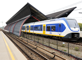
Tramlijn 5 is a tram route in the capital of the Netherlands, Amsterdam. The route runs between Van Hallstraat and the town of Amstelveen, and is operated by the municipal transport company GVB. The line has twenty-seven stops with an average journey time of forty minutes end-to-end.
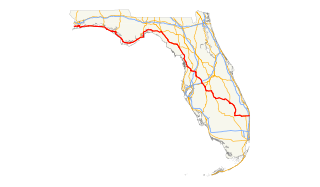
U.S. Route 98 is an east-west United States highway that runs 671 miles (1,080 km) from the Alabama-Florida state line to southern Florida. It is the longest US road in Florida. It was established in 1933 as a route between Pensacola and Apalachicola, and has since been extended eastward across the Florida Peninsula and westward into Mississippi. It runs along much of the Gulf Coast between Mobile, Alabama and Crystal River, Florida, including extensive sections closely following the coast eastward from the Alabama-Florida state line to St. Marks. At a length of 671 miles, US 98 is the longest numbered route in the state of Florida.

Warrington Corporation Tramways was the owner and operator of an electric tramway system in the early 20th century serving the town of Warrington, at the time a county borough of Lancashire, England.

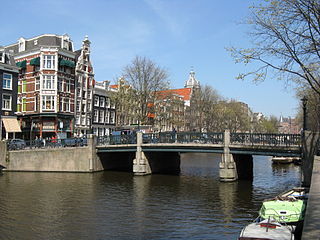
The Muntplein is a square in the centre of Amsterdam. The square is in fact a bridge — the widest bridge in Amsterdam — which crosses the Singel canal at the point where it flows into the Amstel river. All bridges in Amsterdam are numbered, and the Muntplein carries the number 1.
Amsterdam RAI is a railway station situated in southern Amsterdam, Netherlands. It is located between the two directions of the A10 Amsterdam ring road. It is also a metro station at which GVB runs two lines. RAI gets its name from the nearby Amsterdam RAI Exhibition and Convention Centre.

Indische Buurt is a neighborhood in the borough of Oost, the eastern part of the city of Amsterdam, Netherlands. The name of the neighborhood dates from the early 20th century, and is derived from the fact that the neighborhood's streets are named after islands and other geographical concepts in the former Dutch colony of the Dutch East Indies or now known as Indonesia. The first street was named in 1902.

High Peak Junction, near Cromford, Derbyshire, England, is the name now used to describe the site where the former Cromford and High Peak Railway (C&HPR), whose workshops were located here, meets the Cromford Canal. It lies within Derwent Valley Mills World Heritage Site, designated in 2001, and today marks the southern end of the High Peak Trail, a 17 miles (27 km) trail for walkers, cyclists and horse riders. The Derwent Valley Heritage Way also passes this point, and popular walks lead from here along the towpath in both directions.

The Singelgracht is the waterway that borders the entire Amsterdam Center and flows along the Nassaukade, Stadhouderskade and Mauritskade. Formerly the canal and the ramparts on the city side formed the outer defenses of the city.

The Rozengracht is a street in the Jordaan neighbourhood of Amsterdam. It runs between the Prinsengracht at the Westermarkt and the Singel canal at De Clercqstraat. The name means "Rose canal".
The Dijksgracht is a canal in the center of Amsterdam, on Oostenburg island, one of the three Oostelijke Eilanden . It is also the name of the adjacent street.
The Geldersekade is a canal and a street in Amsterdam that connects the Nieuwmarkt with the Prins Hendrikkade. The Geldersekade is in the easternmost part of De Wallen, the red light district, and borders Chinatown.

The Smallepadsgracht is a short and narrow canal in the Amsterdam-Centrum district of Amsterdam. It is in the Westelijke Eilanden neighborhood.

The Plantage Muidergracht is a canal and street in the Plantage neighborhood of Amsterdam. On and along the Plantage Muidergracht, near Roeterseiland, are some of the buildings of the University of Amsterdam, originally built for courses or subfaculties of physics, chemistry, biology, environmental science and mathematics, but now used by other faculties.
The Schippersgracht is a canal and street in the Centrum district of Amsterdam that runs from the Rapenburgerplein to the Prins Hendrikkade.