The Dutch East India Company, officially the United East India Company, was a multinational corporation founded by a government-directed consolidation of several rival Dutch trading companies in the early 17th century. It is believed to be the largest company to ever have existed in recorded history. It was established on March 20, 1602, as a chartered company to trade in pepper and spices with South Asia and Southeast Asia after the Spanish tried to block access to trade routes.

IJmuiden is a port city in the Dutch province of North Holland. It is the main town in the municipality of Velsen which lies mainly to the south-east. Including its large sea locks, it straddles the mouth of the North Sea Canal to Amsterdam. To the south it abuts a large reserve of plant-covered dunes, the Zuid-Kennemerland National Park. The city is on the south bank; the north bank is otherwise a steel plant and Velsen-Noord.
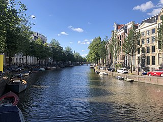
The Keizersgracht is a canal in Amsterdam, the Netherlands. It is the second of the three main Amsterdam canals that together form the Grachtengordel, or canal belt, and lies between the inner Herengracht and outer Prinsengracht.

Amsterdam, capital of the Netherlands, has more than 100 kilometers (62 mi) of grachten (canals), about 90 islands and 1,500 bridges. The three main canals, dug in the 17th century during the Dutch Golden Age, form concentric belts around the city, known as the Grachtengordel. Alongside the main canals are 1550 monumental buildings. The 17th-century canal ring area, including the Prinsengracht, Keizersgracht, Herengracht and Jordaan, were listed as UNESCO World Heritage Site in 2010, contributing to Amsterdam's fame as the "Venice of the North".

The Oost-Indisch Huis is an early 17th-century building in the centre of Amsterdam. It was the headquarters of the Amsterdam chamber of the Dutch East India Company. It is a listed Dutch national heritage site (rijksmonument).

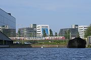
The Eastern Docklands is a neighborhood of Amsterdam, Netherlands, located between the IJ and the Amsterdam–Rhine Canal in the borough of Amsterdam-Oost. The harbor area was constructed in the late nineteenth century to allow for increasing trade with the Dutch East Indies; a new location was necessitated by the construction of the Amsterdam Centraal railway station, which replaced the old quays. East of the new station was a marshy area called De Rietlanden, with the Zeeburgerdijk, running via the Zeeburch, a fort, to the Zuiderzee.

The KNSM Island is a man-made island in the Eastern Docklands of Amsterdam. KNSM stands for the Koninklijke Nederlandsche Stoomboot-Maatschappij, the Royal Dutch Steamboat Shipping company which used to have its headquarters and its docks on the island. It is now a large residential area containing modern architecture with a mostly well-off population.

Oostelijke Eilanden, also known as Oostelijke Eilanden en Kadijken, is a neighbourhood in the centre of Amsterdam, Netherlands, consisting of Kattenburg, Wittenburg and Oostenburg.

Westelijke Eilanden are three islands in the Centrum district of Amsterdam: Bickerseiland, Prinseneiland and Realeneiland. They are located to the south of the IJ and the Zeeheldenbuurt, to the north of the railway line between Central Station and Amsterdam-Sloterdijk, to the west of the Westerdok and to the east of the Planciusbuurt on the Westerkanaal. The Westelijke Eilanden form the core of the Golden Reael area, which also includes the adjacent Westerdok island, the Haarlemmerbuurt and the Planciusbuurt.

Dutch colonial architecture in Indonesia were built across the archipelago that once was known as Dutch East Indies. Most of the better and permanent colonial era structures are located in Java and Sumatra, which were economically considered more important during the Dutch imperial period. As a result, there are large number of colonial buildings concentrated in its cities. Plenty of old VOC era forts and warehouses are also scattered throughout the archipelago, particularly around Maluku Islands and Sulawesi. There are three Dutch colonial architectural styles:

The Admiraliteitslijnbaan is a 17th-century building on Oostenburgergracht canal in Amsterdam. It has held rijksmonument status since 1970. A plaque on one side of the building commemorates Czar Peter the Great, who may have stayed here in 1697 during his apprenticeship at the Amsterdam shipyards.
The Nieuwe Herengracht is a canal in Centrum district of Amsterdam. The canal is an extension of the Herengracht that runs between the Amstel and the Scharrebiersluis (lock) leading to the Schippersgracht from the Entrepotdok. It is in the Plantage neighborhood in the eastern part of the Grachtengordel.
The Dijksgracht is a canal in the center of Amsterdam, north of the three Oostelijke Eilanden. It is also the name of the adjacent street.

The Entrepotdok, formerly Nieuwe Rapenburgergracht, is a canal in Amsterdam, and a street and row of former warehouses with the same name along the northeast side of the canal. They were constructed between 1708 and 1829, used for storage, squatted in the 1990s and are now converted into apartments. Entrepotdok is the largest inhabited warehouse complex in Amsterdam. The canal runs between the Kadijksplein and Sarphatistraat, and is parallel to Hoogte Kadijk, Laagte Kadijk, Plantage Doklaan and Natura Artis Magistra zoo.

The Nieuwe Vaart or Nieuwevaart is a 17th-century canal in Amsterdam that runs from the center to Amsterdam-Oost.

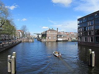
The Oudeschans, or Oude Schans, originally the Nieuwe Gracht, is a wide canal in the eastern part of the inner city of Amsterdam.
The Eilandsgracht is a canal in Amsterdam between the Westelijke Eilanden and the mainland. It originally ran between the mainland and two of the islands, Prinseneiland and Bickerseiland. In 1928 the section along Bickerseiland was filled in.
The Prinseneilandsgracht is a canal in the Centrum district of Amsterdam. It runs between Prinseneiland, an artificial island, to the east and the mainland to the west. Until after World War II (1939–45) the canal was bordered almost exclusively by warehouses and factories.
Martelaarsgracht is a street and former canal in Amsterdam, the Netherlands.
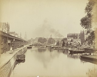
The Oosterdok is a former wet dock in Amsterdam. It was created in 1831-1832 by constructing the Oosterdoksdam and the Oosterdoksluis, forming a reliable deep port closed off from the tidal IJ.