History
The Snoekjesgracht, originally called Snoeksgracht, was named after a 16th-century resident, Jan Pieters Snoeck, who had a house built on this canal in 1595 and depicted a pike (fish) on the facade. [1]
The Snoekjesgracht is located in the old Jodenbuurt (Jewish quarter) of Amsterdam. During the German occupation in World War II many Jewish residents were deported to Nazi concentration camps where they died. [2]
After the war, many of the buildings on the east side were demolished and replaced by new buildings in the 1980s .
In the past the Snoekjesgracht extended further north, between Sint Antoniesbreestraat and Dijkstraat, but in 1867 this part (called the Rotterdammersloot) was filled in. In 2003, the Amsterdam-Centrum district investigated whether the filled-in Rotterdammersloot was suitable for being dug out again, but abandoned this because of the existing buildings and lack of space. [3]
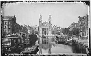
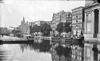
Snoekjesgracht looking north to the Snoekjesbrug (Bridge 289) (1930)
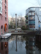
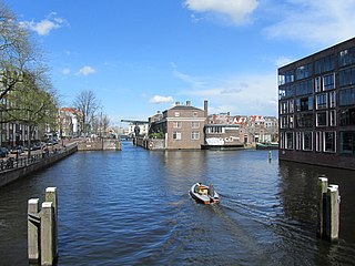
Snoekjesgracht looking to the north, with buildings from the 1980s and the pillar-shaped artwork by Wim Tap.
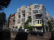
Snoekjesgracht 2016

Noordwijk is a town and municipality in the west of the Netherlands, in the province of South Holland. The municipality covers an area of 74.94 km2 (28.93 sq mi) of which 16.57 km2 (6.40 sq mi) is water and had a population of 44,062 in 2021.
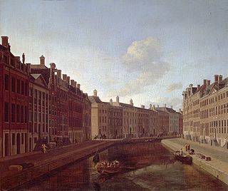
The Herengracht is the second of four Amsterdam canals belonging to the canal belt and lies between the Singel and the Keizersgracht. The Gouden Bocht in particular is known for its large and beautiful canal houses.

Amsterdam, capital of the Netherlands, has more than 100 kilometers (62 mi) of grachten (canals), about 90 islands and 1,500 bridges. The three main canals, dug in the 17th century during the Dutch Golden Age, form concentric belts around the city, known as the Grachtengordel. Alongside the main canals are 1550 monumental buildings. The 17th-century canal ring area, including the Prinsengracht, Keizersgracht, Herengracht and Jordaan, were listed as UNESCO World Heritage Site in 2010, contributing to Amsterdam's fame as the "Venice of the North".

The Eastern Docklands is a neighborhood of Amsterdam, Netherlands, located between the IJ and the Nieuwe Vaart in the borough of Amsterdam-Oost. The harbor area was constructed in the late nineteenth century to allow for increasing trade with the Dutch East Indies; a new location was necessitated by the construction of the Amsterdam Centraal railway station, which replaced the old quays. East of the new station was a marshy area called De Rietlanden, with the Zeeburgerdijk, running via the Zeeburch, a fort, to the Zuiderzee.
The Jodenbuurt is a neighbourhood of Amsterdam, Netherlands. For centuries before World War II, it was the center of the Dutch Jews of Amsterdam — hence, its name. It is best known as the birthplace of Baruch Spinoza, the home of Rembrandt, and the Jewish ghetto of Nazi occupation of the Netherlands.
Lastage is a neighborhood in the Centrum borough of Amsterdam, Netherlands. It is located between the Geldersekade and Oudeschans canals, just east of old medieval city. Today, the neighbourhood is also known as Nieuwmarktbuurt due to the fact that the Nieuwmarkt is comprised in the area; it is protected as a heritage site.

Nieuwmarkt is an underground metro station in the city centre of Amsterdam, Netherlands. Served by metro lines 51, 53, and 54 of the Amsterdam Metro, the station was constructed by sinking caissons with a length of 40 metres (130 ft). This construction method resulted in the demolition of parts of the Nieuwmarkt neighbourhood and was met with protests.

The Waag is a 15th-century building on Nieuwmarkt square in Amsterdam. It was originally a city gate and part of the walls of Amsterdam. Later it served as a guildhall, museum, fire station and anatomical theatre, among other things.
The Kadijken, also known as Kadijkseiland[kɑˈdɛiks.ɛiˌlɑnt] or Kadijkenbuurt[kɑˈdɛikə(m)ˌbyːrt], is a neighbourhood to the north of Artis zoo in the centre of Amsterdam. The name "Kadijken" is the plural form of Kadijk and refers to the two main streets that traverse the neighbourhood, Hoogte Kadijk and Laagte Kadijk.

The walls of Amsterdam were built in the Middle Ages to protect the city against attack. The Medieval walls were replaced with a series of bastions in the 17th century. In the 19th century, the walls were torn down and replaced with the Defence Line of Amsterdam, a fortification line which encircled Amsterdam at a distance from the city.

Vijzelgracht metro station is a station on the Route 52 of the Amsterdam Metro in Amsterdam, Netherlands. It was opened on 22 July 2018.
The Nieuwe Herengracht is a canal in Centrum district of Amsterdam. The canal is an extension of the Herengracht that runs between the Amstel and the Scharrebiersluis (lock) leading to the Schippersgracht from the Entrepotdok. It is in the Plantage neighborhood in the eastern part of the Grachtengordel.
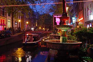
The Oudezijds Achterburgwal, often abbreviated to OZ Achterburgwal, is a street and canal in De Wallen, the red light district in the center of Amsterdam.

The Kromboomssloot, or Krom Boomssloot, is a canal in the Lastage (Nieuwmarktbuurt) neighborhood in the center of Amsterdam. It provides a transverse navigation from the Rechtboomssloot and was previously called Dwarsboomssloot. As the names indicate, the Rechtboomssloot is completely straight, while there is a curve in the Kromboomssloot.

The Oudeschans, or Oude Schans, originally the Nieuwe Gracht, is a wide canal in the eastern part of the inner city of Amsterdam.
Martelaarsgracht is a street and former canal in Amsterdam, the Netherlands.
The Leprozengracht was a canal in Amsterdam that defined one side of the Vlooyenburg island. Leprozengracht and the connected Houtgracht canal were filled in 1882 to form the Waterlooplein.
The Houtgracht was a canal in Amsterdam that defined one side of Vlooyenburg island. Houtgracht and the connected Leprozengracht canal were filled in 1882 to form the Waterlooplein.

Prins Hendrikkade is a major street in the centre of Amsterdam. It passes Amsterdam Central Station, intersects the Damrak at the mouth of the Amstel river, and forms the southern end of the IJtunnel across the IJ bay. The street formed the northern edge and outer harbour of the city until the 19th century. It was named after Prince Henry of the Netherlands, youngest son of King William II, following Henry's death in 1879.