Üsküdar is a municipality and district of Istanbul Province, Turkey. Its area is 35 km2, and its population is 524,452 (2022). It is a large and densely populated district on the Anatolian (Asian) shore of the Bosphorus. It is bordered to the north by Beykoz, to the east by Ümraniye, to the southeast by Ataşehir and to the south by Kadıköy; with Karaköy, Kabataş, Beşiktaş, and the historic city center of Fatih facing it on the opposite shore to the west. Üsküdar has been a conservative cultural center of the Anatolian side of Istanbul since Ottoman times with its numerous historic landmark and little mosques and dergahs.

Beşiktaş is a district and municipality of Istanbul Province, Turkey. Its area is 18 km2, and its population is 175,190 (2022). It is located on the European shore of the Bosphorus strait. It is bordered on the north by Sarıyer and Şişli, on the west by Kağıthane and Şişli, on the south by Beyoğlu, and on the east by the Bosphorus. Directly across the Bosphorus is the district of Üsküdar.

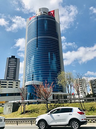
Maltepe is a municipality and district of Istanbul Province, Turkey. Its area is 53 km2, and its population is 528,544 (2022). It is on the northern shore of the Sea of Marmara, adjacent to the Kadıköy district to the west, Kartal district to the east and Ataşehir district to the northwest. The mayor of Maltepe is Ali Kılıç (CHP).

Kadıköy, known in classical antiquity and during the Roman and Byzantine eras as Chalcedon, is a municipality and district of Istanbul Province, Turkey. Its area is 25 km2, and its population is 483,064 (2022). It is a large, populous, and cosmopolitan area in the Asian side of Istanbul, on the northern shore of the Sea of Marmara. It partially faces the historic city centre of Fatih on the European side of the Bosporus. One of the most expensive neighborhoods in Istanbul, Kadıköy is also the name of the most prominent neighbourhoods of the district, a residential and commercial area that, with its numerous bars, cinemas and bookshops, is the liberal cultural centre of the Anatolian side of Istanbul. Kadıköy became a district in 1928 when it was separated from Üsküdar district. The neighbourhoods of İçerenköy, Bostancı and Suadiye were also separated from the district of Kartal in the same year, and eventually joined the newly formed district of Kadıköy. Its neighbouring districts are Üsküdar to the northwest, Ataşehir to the northeast, Maltepe to the southeast, and Kartal beyond Maltepe.

Şişli is municipality and district of Istanbul Province, Turkey. Its area is 10 km2, and its population is 276,528 (2022). Located on the European side of the city, it is bordered by Beşiktaş to the east, Sarıyer to the north, Eyüp and Kağıthane to the west, and Beyoğlu to the south. It is also the name of a specific area of Şişli district centered on the Sişli Mosque.
Ataşehir is a municipality and district of Istanbul Province, Turkey. Its area is 25 km2, and its population is 423,127 (2022). It is located at the junction of the O-2 and O-4 motorways on the Anatolian (Asian) side of Istanbul. Its neighbours are the districts of Ümraniye to the north, Sancaktepe to the northeast, Maltepe to the east, Kadıköy to the south and Üsküdar to the west.

Levent is a neighbourhood in the municipality and district of Beşiktaş, Istanbul Province, Turkey. Its population is 2,911 (2022). It is one of the main business districts of Istanbul located on the European side of the city. It is situated to the north of the Golden Horn, at the western shore of the Bosphorus strait.

Maslak is a neighbourhood in the municipality and district of Sarıyer, Istanbul Province, Turkey. Its population is 12,260 (2022). It is one of the main business districts of Istanbul, located on the European side of the city. It was formerly an exclave of the municipality of Şişli, though being far north and actually closer to the municipalities of Sarıyer and Beşiktaş. In 2012, the jurisdiction of the Maslak district was shifted from Şişli to Sarıyer.

Bostancı is a neighbourhood in the municipality and district of Kadıköy, Istanbul Province, Turkey. Its population is 33,638 (2022). It is on the Anatolian side of Istanbul, on the shore of the Sea of Marmara. As the easternmost neighbourhood of the Kadıköy district; it borders Suadiye and Kozyatağı to the west, İçerenköy to the north, and Altıntepe to the east.
The Istanbul Metro is a rapid transit railway network that serves the city of Istanbul, Turkey. Apart from the M11 line, which is operated by TCDD Taşımacılık, the system is operated by Metro Istanbul, a public enterprise controlled by the Istanbul Metropolitan Municipality. The oldest section of the metro is the M1 line, which opened in 1989. As of April 2023, the system now includes 137 stations in service, with 56 more under construction.
Mecidiyeköy is a neighbourhood in the municipality and district of Şişli, Istanbul Province, Turkey. Its population is 20,006 (2022). It is a heavily built-up residential and business neighbourhood, squeezed in between the Fulya, Kuştepe, Gültepe, Esentepe, and Gülbahar neighbourhoods.

Zorlu Center is a multiple-use complex in the Beşiktaş district of Istanbul, Turkey containing an upscale shopping mall, a five-star Raffles hotel and a Cinemaximum megaplex, as well as residences and offices. It is home to Zorlu PSM, the largest performing arts center in the country, as well as the country's first Apple Store.

Zincirlikuyu is a quarter of the Şişli district on the European side of Istanbul, Turkey. Part of Esentepe neighborhood, it is situated on a hilltop on the district border to Beşiktaş in the east. Having undergone redevelopment in recent years, the area is also a busy bus hub.
Kozyatağı is a neighbourhood in the municipality and district of Kadıköy, Istanbul Province, Turkey. Its population is 37,743 (2022). It is to the East of Göztepe, northwest of Bostancı, south of Ataşehir and north of the coastal neighbourhoods.

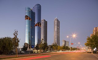
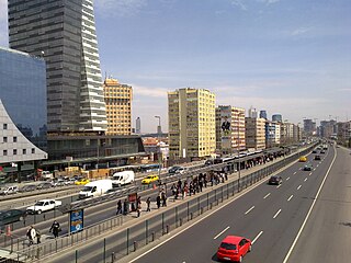
Büyükdere Avenue is a major avenue which runs through the districts of Şişli, Beşiktaş and Sarıyer on the European side of Istanbul, Turkey. It begins at Şişli Mosque and runs in an eastward direction partly under the viaduct of the inner-city motorway O-1 through Mecidiyeköy, Esentepe, until reaching Zincirlikuyu; where it joins with Barbaros Boulevard and turns northward passing through Levent, Sanayi Mahallesi, Maslak and by the Fatih Forest, ending at the Hacıosman Slope on the Sarıyer district border. Its total length is 14 km (8.7 mi). From Zincirlikuyu to Maslak, it forms a border line between the districts of Kağıthane in the east and Beşiktaş in the west. It is named after the Büyükdere neighborhood of Sarıyer district, where it connects to. It is a major artery of the Istanbul Central Business District, which is not located in the historic center of the city.

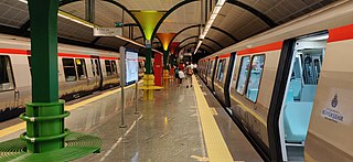
Levent is an underground station on the M2 line of the Istanbul Metro. It is located under Büyükdere Avenue in Levent, the main financial district of Istanbul. Opened on 16 September 2000, Levent is one of the M2 line's six original stations. The station offers connections to İETT city bus service along Büyükdere Avenue, one of the busiest urban roadways in Turkey. Many important financial centers are in the immediate vicinity of the station such as the İşbank Tower 1, Yapı Kredi Headquarters and the Kanyon Shopping Mall which has an underground connection to the station.

The following outline is provided as an overview of and topical guide to Istanbul:
Istanbul's Central Business District as the real estate industry refers to it, is not the historic city center, but a 7-km-long north–south corridor of modern areas mostly along Barbaros Boulevard and Büyükdere Avenue. As of late 2021, 33% of the Class A office space in the metropolitan area was located in the CBD, of which about 790,000 sqm in Maslak, 690,000 sqm in Levent, 500,000 sqm in Zincirlikuyu/Esentepe/Gayrettepe and 100,000 sqm in Etiler.