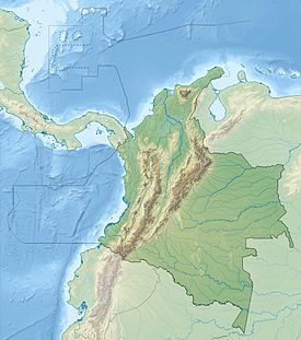
Major volcanoes in Colombia
This is a list of active and extinct volcanoes in Colombia.
This is a list of active and extinct volcanoes in Colombia.
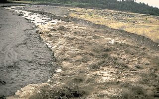
A lahar is a violent type of mudflow or debris flow composed of a slurry of pyroclastic material, rocky debris and water. The material flows down from a volcano, typically along a river valley.

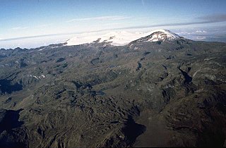
The Nevado del Ruiz, also known as La Mesa de Herveo is a volcano on the border of the departments of Caldas and Tolima in Colombia, about 129 kilometers (80 mi) west of the capital city Bogotá. It is a stratovolcano composed of many layers of lava alternating with hardened volcanic ash and other pyroclastic rocks. Volcanic activity at Nevado del Ruiz began about two million years ago, since the Early Pleistocene or Late Pliocene, with three major eruptive periods. The current volcanic cone formed during the present eruptive period, which began 150,000 years ago.
The Volcano Disaster Assistance Program (VDAP) was developed by the U.S. Geological Survey and the United States Agency for International Development's Office of U.S. Foreign Disaster Assistance after the eruption of Nevado del Ruiz (Colombia) in 1985. The volcanic eruption melted a glacier triggering a lahar that killed 25,000 people. It was determined that increased monitoring and enhanced communications between scientists and civil authorities would make it easier to evacuate local populations and save lives. Today the program responds to volcanic crises around the world. The aim of the program is to assist in saving lives and property, to reduce economic losses, and to prevent a natural hazard becoming a natural disaster. VDAP staff members are based at the USGS Cascades Volcano Observatory, in Vancouver, Washington. VDAP channels its energy into four main activities: response to natural disaster, capacity building, training, and volcanological research.

Galeras is an Andean stratovolcano in the Colombian department of Nariño, near the departmental capital Pasto. Its summit rises 4,276 metres (14,029 ft) above sea level. It has erupted frequently since the Spanish conquest, with its first historical eruption being recorded on December 7, 1580. A 1993 eruption killed nine people, including six scientists who had descended into the volcano's crater to sample gases and take gravity measurements in an attempt to be able to predict future eruptions. It is currently the most active volcano in Colombia.
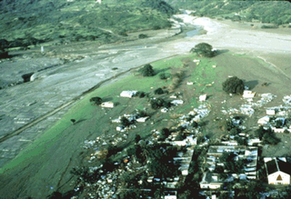
The Armero tragedy occurred following the eruption of the Nevado del Ruiz stratovolcano in Tolima, Colombia, on November 13, 1985. After 69 years of dormancy, the volcano's eruption caught nearby towns unaware, even though the government had received warnings from volcanological organizations to evacuate the area after the detection of volcanic activity two months earlier.

Nevado de Toluca is a stratovolcano in central Mexico, located about 80 kilometres (50 mi) west of Mexico City near the city of Toluca. It is the fourth highest of Mexico's peaks, after Pico de Orizaba, Popocatépetl and Iztaccíhuatl. The volcano and the area around it is now a national park.

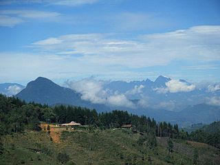
The Cordillera Central is the highest of the three branches of the Colombian Andes. The range extends from south to north dividing from the Colombian Massif in Cauca Department to the Serranía de San Lucas in Bolivar Departments. The highest peak is Nevado del Huila at 5,364 m (17,598 ft).

The Nevado del Quindío is an inactive volcano located in the Central Cordillera of the Andes in central Colombia. The summit marks the tripoint of the departments of Risaralda, Quindío and Tolima, and is also the highest point of the departments of Risaralda and Quindío. The mountain is one of the highest peaks in the Los Nevados National Natural Park, which is a wildlife sanctuary. There are no historical records of any eruption. The andesitic volcano is located on top of the Palestina Fault.

The Nevado del Tolima is a Late Pleistocene to recently active andesitic stratovolcano located in the Tolima department, Colombia. The volcano lies south of Nevado del Ruiz volcano and is situated within the Los Nevados National Natural Park. The volcano, whose most recent activity dates to 1943 and last major eruption around 3600 years ago, overlies the Eocene El Bosque Batholith, dated at 49.1 ± 1.7 Ma.
Santa Isabel is a shield volcano located in Tolima, Colombia, southwest of Nevado del Ruiz volcano. The volcano is located over the Palestina Fault, that crosscuts the underlying El Bosque Batholith of Eocene age, dated at 49.1 ± 1.7 Ma.
Cerro Bravo is a stratovolcano located in Tolima, Colombia, north of the Nevado del Ruiz volcano. The rock type of the volcano is andesite.

Cerro Machín is a stratovolcano located in Tolima Department, Colombia. Cerro Machin is a volcanic plug that is approximately the same age as the Ruiz-Tolima Massif and has the appearance of being part of that volcanic system. Its sisters are Nevado del Tolima, 17,060 feet (5,200 m); Santa Isabel, 16,240 feet (4,950 m), Nevado del Ruiz, 17,457 feet (5,321 m), plus nine other lesser volcanoes and a 10,000 feet (3,000 m) volcanic South Wall containing in excess of thirty volcanic domes.

Nevado del Huila at 5,364 metres (17,598 ft), is the highest volcano in Colombia, located at the tripoint of the departments of Huila, Tolima and Cauca. It is visible from the city of Cali. The andesitic volcano is located on top of the Ibagué Batholith.

Puracé is an andesitic stratovolcano located in the Puracé National Natural Park in the Cauca Department, Colombia. It is part of the North Volcanic Zone of the Andean Volcanic Belt. The volcano is located at the intersection of the Coconucos and Morras Faults.

Doña Juana is a stratovolcano, located within the Doña Juana-Cascabel Volcanic Complex National Natural Park in Nariño, Colombia.
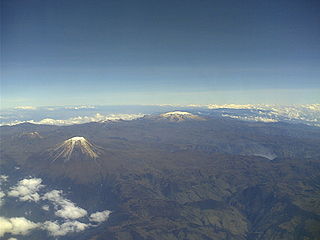
Los Nevados National Natural Park is a national park located in the Cordillera Central of the Colombian Andes. The park surrounds the northern volcanic complex formed by Nevado del Ruiz, Nevado del Tolima, Nevado de Santa Isabel, the paramillos of Cisne, Santa Rosa and Quindío and the Cerro Bravo and Cerro Machín.
The Nevado El Cisne is a volcano in the Central Ranges of the Andes in Colombia. Its summit is at an altitude of 4,636 metres (15,210 ft). The mountain is one of the five lava domes of the Nevado del Ruiz volcano complex. Despite the nevado part of the name, indicating a permanently snow-capped mountain, the summit of El Cisne is now below the permanent snow line as a result of global warming, and it is no longer considered a true nevado. The volcano is located over the Palestina Fault, that crosscuts the underlying El Bosque Batholith of Eocene age, dated at 49.1 ± 1.7 Ma.
The Irlanda Fault is a dextral strike-slip fault in the department of Cauca in south-central Colombia. A small portion of the fault runs through Huila. The fault has a total length of 54.6 kilometres (33.9 mi) and runs along an average northeast to southwest strike of 023 ± 4 in the Central Ranges of the Colombian Andes. The fault is active and associated with the deadly 1994 Páez River earthquake.
The Palestina Fault is a regional sinistral oblique thrust fault in the departments of Antioquia, Caldas and Bolívar in central Colombia. The fault has a total length of 369.6 kilometres (229.7 mi) and runs along an average north-northeast to south-southwest strike of 017.8 ± 11 along the Central Ranges of the Colombian Andes.
The Colombian Geological Survey (CGS) is a scientific agency of the Colombian government in charge of contributing to the socioeconomic development of the nation through research in basic and applied geosciences of the subsoil, the potential of its resources, evaluating and monitoring threats of geological origin, managing the geoscientific knowledge of the nation, and studying the nuclear and radioactive elements in Colombia.
| Western Ranges |  | |
|---|---|---|
| Central Ranges | ||
| Eastern Ranges | ||
| Other | ||
| Source | ||