This article needs additional citations for verification .(July 2007) |
This is a list of active and extinct volcanoes in Ecuador.
Contents
In Ecuador, EPN monitors the volcanic activity in this Andean nation. [1]
This article needs additional citations for verification .(July 2007) |
This is a list of active and extinct volcanoes in Ecuador.
In Ecuador, EPN monitors the volcanic activity in this Andean nation. [1]
| Name | Meters | Feet | Coordinates | Last Eruption |
|---|---|---|---|---|
| Alcedo | 1130 | 3706 | 0°26′S91°07′W / 0.43°S 91.12°W | 1993 |
| Cerro Azul | 1640 | 5379 | 0°54′S91°25′W / 0.90°S 91.42°W | 2008 |
| Darwin | 1330 | 4362 | 0°11′S91°17′W / 0.18°S 91.28°W | 1813 |
| Ecuador | 790 | 2591 | 0°01′12″S91°32′46″W / 0.02°S 91.546°W | 1150 |
| Fernandina Island (La Cumbre) | 1495 | 4904 | 0°22′S91°33′W / 0.37°S 91.55°W | 2020 |
| Cerro Pajas | 640 | 2099 | 1°18′S90°27′W / 1.30°S 90.45°W | Holocene |
| Galápagos Rift | -2430 | -7972 | 0°47′31″N86°09′00″W / 0.792°N 86.15°W | 1996 |
| Genovesa | 64 | 210 | 0°19′12″N89°57′29″W / 0.32°N 89.958°W | - |
| Marchena | 343 | 1125 | 0°20′S90°28′W / 0.33°S 90.47°W | 1991 |
| Pinta | 780 | 2558 | 0°35′S90°45′W / 0.58°S 90.75°W | 1928 |
| San Cristóbal | 759 | 2490 | 0°53′S89°30′W / 0.88°S 89.50°W | - |
| Santa Cruz | 964 | 2834 | 0°37′S90°20′W / 0.62°S 90.33°W | - |
| Santiago | 920 | 3018 | 0°13′S90°46′W / 0.22°S 90.77°W | 1906 |
| Sierra Negra | 1124 | 3687 | 0°50′S91°10′W / 0.83°S 91.17°W | 2018 |
| Wolf | 1710 | 5609 | 0°01′N91°21′W / 0.02°N 91.35°W | 2022 |
Tungurahua is an active stratovolcano located in the Cordillera Oriental of Ecuador. The volcano gives its name to the province of Tungurahua. Volcanic activity restarted on August 19, 1999, and is ongoing as of 2023, with several eruptive episodes since then, the most recent lasting from February 26 to March 16, 2016.

Chimborazo is an inactive stratovolcano situated in the Cordillera Occidental range of the Andes. Its last known eruption is believed to have occurred around 550 A.D. Despite not being the tallest mountain in the Andes or on Earth, its summit holds the distinction of being the farthest point on Earth's surface from the Earth's center, due to its location along the planet's equatorial bulge. Chimborazo's height is 6,263 m, well below that of Mount Everest.

Cotopaxi is an active stratovolcano in the Andes Mountains, located near Latacunga city of Cotopaxi Province, about 50 km (31 mi) south of Quito, and 31 km (19 mi) northeast of the city of Latacunga, Ecuador. It is the second highest summit in Ecuador, reaching a height of 5,897 m (19,347 ft). Cotopaxi is among the highest active volcanoes in the world.

The Illinizas are a pair of volcanic mountains that are located in the north of Latacunga, Cotopaxi, Ecuador. They are located in the Illinizas Ecological Reserve. These twin mountains are separated by a saddle that is about a kilometer long. The peaks are among the highest in Ecuador, with Illiniza Sur standing slightly taller than Illiniza Norte, its northern counterpart, at 5245 metres and 5126 metres respectively.

Cotopaxi is one of the provinces of Ecuador. The capital is Latacunga. The province contains the Cotopaxi Volcano, an intermittent volcano with a height of 19,347 feet (5,897 m).

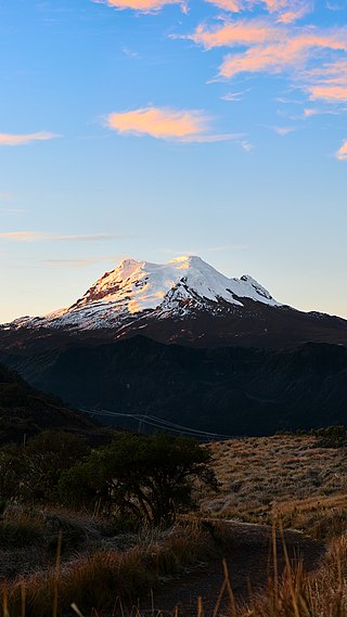
Cayambe or Volcán Cayambe is a volcano in Ecuador, in the Cordillera Central, a range of the Ecuadorian Andes. It is located in Pichincha Province, some 70 km (43 mi) northeast of Quito. It is the third-highest mountain in Ecuador, at an elevation of 5,790 m (18,996 ft) above sea level.

Rumiñahui is a dormant, heavily eroded stratovolcano 4,721 metres (15,489 ft) above sea level. Situated in the Andes mountains 40 km south of Quito, Ecuador, it is overshadowed by its famous neighbour Cotopaxi.

Latacunga is a plateau city of Ecuador, capital of the Cotopaxi Province, 89 km (55 mi) south of Quito, near the confluence of the Alaquez and Cutuchi rivers to form the Patate, the headstream of the Pastaza. At the time of census 2022 Latacunga had a population of 77,267 largely mestizo and indigenous.
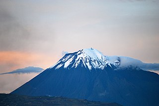
Antisana is a stratovolcano of the northern Andes, in Ecuador. It is the fourth highest volcano in Ecuador, at 5,753 metres (18,875 ft), and is located 50 kilometres (31 mi) SE of the capital city of Quito.
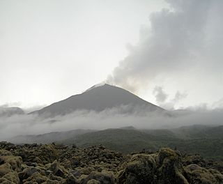
Reventador is an active stratovolcano which lies in the eastern Andes of Ecuador. It lies in a remote area of the national park of the same name, which is Spanish for "exploder". Since 1541, it has erupted over 25 times, although its isolated location means that many of its eruptions have gone unreported.

Mejía is a canton in the province of Pichincha in northern Ecuador. It is named after Ecuadorian political figure José Mejía Lequerica. The canton includes a volcano in the Central Cordillera of the Ecuadorian Andes called Rumiñahui. The seat of the canton is called Machachi.
Cotopaxi is a volcano in Ecuador.
Machachi is the canton seat of Mejía Canton in the Pichincha province of Ecuador.

The National Polytechnic School, also known as EPN, is a public university in Quito, Ecuador. The campus, called "José Rubén Orellana", is located at the sector center-oriental of Quito. It occupies an area of 15.2 hectares and has a built area of around 62,000 metres2. Its student body numbers approximately 10,000 of which thirty percent are women. The main campus encompasses ten teaching and research faculties, in addition to four technical and specialized institutes. EPN was founded in 1869 with the aim of becoming the first technical and technological center in the country. Since its beginnings, EPN adopted the polytechnic university model, which stresses laboratory instruction in applied science and engineering. At the campus, there are some libraries with a content primarily oriented to engineering and scientific topics.
Cotopaxi National Park is a protected area in Ecuador situated in the Cotopaxi Province, Napo Province and Pichincha Province, roughly 50 km (31 mi) south of Quito. The Cotopaxi volcano that lends its name to the park is located within its boundaries, together with two others: the dormant Rumiñawi volcano to its north-west and the historical Sincholagua volcano to the south east. Cotopaxi is among the highest active volcanoes in the world. Its most recent eruption began on 14 August 2015, and ended on 24 January 2016.

Sincholagua is an inactive volcano located in Ecuador 17 km (11 mi) northeast of Cotopaxi Volcano and 45 km (28 mi) southeast of Quito. It is the 12th highest peak in the country at 4,899 m (16,073 ft) but also one of the lesser known ones. The name of the mountain comes from the indigenous language Quichua and means "strong above". Due to its close proximity to Cotopaxi, the second highest peak in Ecuador and the most popular volcano, it is far less frequently visited compared to other mountains in the country. It has a sharp peak and at one point had glacial cover year round, but all of the glaciers melted a few decades ago. However, snow can still be seen on the peak since there is sometimes heavy snowfall at the summit.

Cotopaxi is an 1862 oil painting by American artist Frederic Edwin Church, a member of the Hudson River School. The painting depicts Cotopaxi, an active volcano that is also the second highest peak in modern-day Ecuador, spewing smoke and ash across a colorful sunrise. The work was commissioned by well-known philanthropist and collector James Lenox and was first exhibited in New York City in 1863. Cotopaxi was met with great acclaim, seen by some as a "parable" of the Civil War, then raging in the American South, with its casting of light against darkness in a vast tropical landscape. Church first depicted Cotopaxi beginning in 1853 during his first of several travels to South America, forming a series of at least 10 paintings on the subject during his lifetime. Cotopaxi has been called by some art historians the "apex" of the Cotopaxi series or Church's "ultimate interpretation" of the eponymous volcano.

The Mama Negra is a traditional festival held twice a year in Latacunga, Cotopaxi Province, Ecuador. Also called La Santísima Tragedia, it is a celebration in honor of the Virgen de la Merced, who is said to have stopped an eruption of Cotopaxi volcano in 1742. The festival is also a celebration of the anniversary the city of Latacunga's independence.
Patricia (Patty) Ann Mothes is an American volcanologist who has spent most of her career working in Ecuador. She is best known for her work on volcanic hazards and risk in Ecuador.
