Listed buildings in Adwick le Street and Carcroft

Last updated

Adwick le Street and Carcroft is a ward in the metropolitan borough of Doncaster, South Yorkshire, England. The ward contains 33 listed buildings that are recorded in the National Heritage List for England. Of these, one is listed at Grade II*, the middle of the three grades, and the others are at Grade II, the lowest grade. The ward contains the villages of Adwick le Street and Carcroft, and the surrounding area. Most of the listed buildings are in the model village of Woodlands, and consist of houses built for the Brodsworth Colliery Company, and designed by Percy Houfton in Arts and Crafts style. [1] Also in the model village are a church and two schools. Elsewhere, the listed buildings consist of an older church, the remains of a churchyard cross and a memorial in the churchyard, a former water mill, a large house later used as a club, a war memorial in the form of a clock tower, and a miners' welfare institute.

Contents

Key

Map all coordinates using: OpenStreetMap  
Download coordinates as: KML
GradeCriteria [2]
II*Particularly important buildings of more than special interest
IIBuildings of national importance and special interest

Buildings

Name and locationPhotographDateNotesGrade
St Laurence's Church
53°34′16″N1°11′04″W / 53.57121°N 1.18453°W
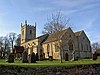
 / 53.57121; -1.18453 (St Laurence's Church)
St Laurence's Church, Adwick le Street from Church Road - geograph.org.uk - 1065437.jpg
12th centuryThe church was extended and altered through the centuries, and was restored in 1862 and 1875. It is built in limestone with stone slate roofs, and consists of a nave, a north aisle, a south porch, a chancel with north chapel and vestry, and a west tower. The tower is in Perpendicular style, and has two stages, diagonal buttresses, a three-light west window, a clock face, a string course with an image niche, cusped two-light bell openings, gargoyles, and an embattled parapet with crocketed pinnacles. [3] [4] II*
Churchyard cross
53°34′16″N1°11′04″W / 53.57107°N 1.18458°W / 53.57107; -1.18458 (Churchyard cross)
Late medieval (probable)The remains of the cross are in the churchyard of St Laurence's Church, and in magnesian limestone. There is a platform of large stones on which is a cross base with chamfered corners. On the top is a square socket containing a truncated chamfered shaft. [5] II
Mill building and tunnel arch
53°34′26″N1°11′03″W / 53.57389°N 1.18416°W / 53.57389; -1.18416 (Mill building and tunnel arch)
1768 (probable)A former water mill, it is in magnesian limestone with quoins and a stone slate roof. There are three storeys, two bays, and a two-storey rear wing. It contains round-arched doorways in the lower two floors, and casement windows. To the left of the rear wing is a tail-race tunnel with a segmental arch and a keystone. [6] II
Woodlands Park Club
53°33′32″N1°11′21″W / 53.559002°N 1.18922°W / 53.559002; -1.18922 (Woodlands Park Club)
c. 1791A large house, later a club, it is in painted magnesian limestone, on a plinth, with a sill band, an eaves cornice, a pediment over the middle three bays, and a hipped Welsh slate roof. There are three storeys, five bays, and recessed two-storey one-bay pavilions. In the centre is a doorway with a fanlight, flanked by canted bay windows. The windows in the middle floor are sashes, and the top floor contains casement windows. In the ground floor of the pavilions is a round-arched recess containing a window, and in the right return is a 19th-century porch. [7] [8] II
Cholera memorial
53°34′17″N1°11′04″W / 53.57134°N 1.18438°W / 53.57134; -1.18438 (Cholera memorial)
c. 1832The memorial is against the east wall of St Laurence's Church, and is in magnesian limestone. It consists of an upright slab about 1.6 metres (5 ft 3 in) high with a cut-off triangular head. On the slab is an inscription to the memory of the five people who died as a result of a cholera epidemic in 1832. [9] II
5 and 6 The Park
53°33′35″N1°11′30″W / 53.55968°N 1.19174°W / 53.55968; -1.19174 (5 and 6 The Park)
1907–08A pair of roughcast semi-detached houses with tile roofs designed by Percy Houfton. They have two storeys, and each house is gabled with two bays. The central doorways have canopies on brackets, and No. 6 has a porch. The windows are casements with hood moulds. [10] II
7–10 The Park
53°33′34″N1°11′31″W / 53.55950°N 1.19185°W / 53.55950; -1.19185 (7–10 The Park)
1907–08A row of four roughcast houses with tile roofs designed by Percy Houfton. They have two storeys, and each house has two bays; the outer houses are gabled. The doorways have canopies on scrolled brackets, and No. 8 has an added porch. The windows are casements, most with hood moulds. [11] II
Terry Holt Cottage
53°33′40″N1°11′34″W / 53.56121°N 1.19291°W / 53.56121; -1.19291 (Terry Holt Cottage)
1907–08A detached house designed by Percy Houfton, it is roughcast with a pantile roof. There are two storeys and two bays, with the front and sides gabled. On the front is a gabled porch, and the windows are casements. [12] II
2–8 Central Avenue
53°33′48″N1°11′57″W / 53.56332°N 1.19918°W / 53.56332; -1.19918 (2–8 Central Avenue)
1908A row of four houses designed by Percy Houfton in red brick, partly roughcast, with tile roofs. There are two storeys and six bays, the outer houses projecting as gabled cross-wings, and the central bays are also gabled. In the gable of the left house is a pair of slit vents under a cornice. The doorways have canopies on scrolled brackets, and windows are casements, some with hood moulds. [13] II
27 and 29 Central Avenue
53°33′53″N1°11′57″W / 53.56470°N 1.19921°W / 53.56470; -1.19921 (27 and 29 Central Avenue)
1908A pair of mirror-image semi-detached houses designed by Percy Houfton. They are in brick on the ground floor, and roughcast above, with a tile roof, two storeys and four bays. Each house has a gabled front, and contains a central doorway with a wooden canopy on curved brackets. The windows are casements with hood moulds. [14] II
31–37 Central Avenue
53°33′54″N1°11′58″W / 53.56491°N 1.19937°W / 53.56491; -1.19937 (31–37 Central Avenue)
1908A row of four roughcast houses designed by Percy Houfton with tile roofs, and two storeys. Each house has two bays, and a central round-headed doorway with rock-faced quoined jambs. The windows are casements, most with hood moulds, those in the ground floor rising over the doorways. In each gable is a plaque with a cross under a hood mould. [15] II
87 and 89 Great North Road
53°34′00″N1°11′52″W / 53.56663°N 1.19767°W / 53.56663; -1.19767 (87 and 89 Great North Road)
1908A pair of mirror-image semi-detached houses designed by Percy Houfton. They are roughcast, with a tile roof, two storeys and four bays. Each house has a gabled front, and contains a central doorway with a wooden canopy on shaped brackets. The windows are casements with hood moulds. [16] II
15 and 17 Green Lane
53°33′52″N1°11′53″W / 53.56448°N 1.19796°W / 53.56448; -1.19796 (15 and 17 Green Lane)
1908A pair of mirror-image semi-detached houses designed by Percy Houfton. They are roughcast, with a tile roof, two storeys and four bays. Each house has a gabled front, and contains a central doorway with a wooden canopy on curved brackets. The windows are casements with hood moulds. [17] II
26–32 Green Lane
53°33′49″N1°11′59″W / 53.56373°N 1.19984°W / 53.56373; -1.19984 (26–32 Green Lane)
1908A group of four houses designed by Percy Houfton, they are in roughcast brick with tile roofs. There are two storeys and six bays. The outer houses project and are gabled. The doorways in the outer houses have canopies on scrolled brackets, and No. 28 has a 20th-century porch. Most of the windows are casements. [18] II
27 and 29 Green Lane
53°33′52″N1°11′55″W / 53.56436°N 1.19872°W / 53.56436; -1.19872 (27 and 29 Green Lane)
1908A pair of mirror-image semi-detached houses designed by Percy Houfton. They are roughcast, with a tile roof, two storeys and four bays. Each house has a gabled front, and contains a central doorway with a wooden canopy on curved brackets. No. 29 has a modern gabled porch, and the windows are casements. [19] II
34–38 Green Lane
53°33′53″N1°12′01″W / 53.56461°N 1.20019°W / 53.56461; -1.20019 (34–38 Green Lane)
1908A row of three houses designed by Percy Houfton. They are in roughcast brick, with a tile roof, two storeys and four bays. The outer houses project and are gabled. The doorways of Nos. 36 and 38 have doorways with wooden canopies on curved brackets, and the windows are casements. [20] II
17–19 Quarry Lane
53°33′47″N1°11′59″W / 53.56299°N 1.19971°W / 53.56299; -1.19971 (17–19 Quarry Lane)
Quarry Lane, Adwick le Street.jpg
1908A row of three houses designed by Percy Houfton, they are in red brick, partly rendered and roughcast, and have a tile roof. There are two storeys, each house has two bays, and over the middle house is a gable. The doorways have canopies on curved brackets. The inner bay of each outer house has a two-storey canted bay window, and the other windows are casements. [21] II
33 and 35 The Crescent
53°33′51″N1°12′06″W / 53.56427°N 1.20176°W / 53.56427; -1.20176 (33 and 35 The Crescent)
1908A pair of mirror-image semi-detached houses designed by Percy Houfton. They are roughcast, with a tile roof, two storeys and four bays. Each house has a gabled front, and contains a central doorway with a wooden canopy on curved brackets. The windows are casements with hood moulds. [22] II
45 and 47 The Crescent
53°33′53″N1°12′07″W / 53.56472°N 1.20194°W / 53.56472; -1.20194 (45 and 47 The Crescent)
1908A pair of mirror-image semi-detached houses designed by Percy Houfton. They are roughcast, with a tile roof, two storeys and four bays. Each house has a gabled front, and contains a central doorway with a wooden canopy on curved brackets. The windows are casements with hood moulds. [23] II
49–53 The Crescent
53°33′54″N1°12′07″W / 53.56492°N 1.20192°W / 53.56492; -1.20192 (49–53 The Crescent)
1908A row of three houses designed by Percy Houfton, they are in red brick, partly rendered and roughcast, and have a tile roof. There are two storeys, each house has two bays, and over the middle house is a gable with a lozenge motif. The doorways have canopies on curved brackets. The inner bay of each outer house has a two-storey canted bay window, and the other windows are casements. [24] II
64 and 66 The Crescent
53°33′53″N1°12′09″W / 53.56486°N 1.20247°W / 53.56486; -1.20247 (64 and 66 The Crescent)
1908A pair of mirror-image semi-detached houses designed by Percy Houfton. They are in red brick and roughcast, with a tile roof, two storeys and four bays. Each house has a gabled front, and contains a central doorway with a wooden canopy on curved brackets. The windows are casements with hood moulds. [25] II
65 and 67 The Crescent
53°33′57″N1°12′05″W / 53.56589°N 1.20141°W / 53.56589; -1.20141 (65 and 67 The Crescent)
1908A pair of mirror-image semi-detached houses designed by Percy Houfton. They are in roughcast brick, with a hipped tile roof, two storeys and four bays, and a gable over the middle two bays. Above the doorways are hood moulds, and the windows are casements. [26] II
73 and 75 The Crescent
53°33′58″N1°12′04″W / 53.56613°N 1.20100°W / 53.56613; -1.20100 (73 and 75 The Crescent)
1908A pair of mirror-image semi-detached houses designed by Percy Houfton. They are in roughcast brick, with a hipped tile roof, two storeys and four bays, and a gable over the middle two bays. Above the doorways are hood moulds, and the windows are casements. [27] II
113 and 115 The Crescent
53°33′55″N1°11′52″W / 53.56539°N 1.19787°W / 53.56539; -1.19787 (113 and 115 The Crescent)
1908A pair of mirror-image semi-detached houses designed by Percy Houfton. They are in roughcast brick, with a hipped tile roof, two storeys and four bays, and a gable over the middle two bays. Above the doorways are hood moulds, and the windows are casements. [28] II
129–135 The Crescent
53°33′53″N1°11′51″W / 53.56475°N 1.19737°W / 53.56475; -1.19737 (129–135 The Crescent)
1908A group of four houses designed by Percy Houfton, they are in red brick and partly roughcast, with tile roofs. There are two storeys and six bays. The outer houses project and have hipped roofs, and over the middle two bays is a gable containing a date plate and a cornice. The doorways have canopies on scrolled brackets. Most of the windows are casements, some with tile hood moulds, and on the inner sides of the middle doorways are oval windows. [29] II
1–7 Harold Avenue
53°34′01″N1°12′01″W / 53.56706°N 1.20024°W / 53.56706; -1.20024 (1–7 Harold Avenue)
1908A row of four roughcast houses with tile roofs and two storeys designed by Percy Houfton. Each house has two bays, and the outer houses are gabled. The doorways are in the centre with rock-faced quoined jambs and a stepped lintel. The lintels in the outer houses have a shield with a cross, and the lintels in the middle houses are peaked and contain a lozenge. The windows are casements. [30] II
23 and 25 West Avenue
53°33′56″N1°12′12″W / 53.56558°N 1.20324°W / 53.56558; -1.20324 (23 and 25 West Avenue)
1908A pair of mirror-image semi-detached houses designed by Percy Houfton. They are in roughcast brick, with a tile roof, two storeys and four bays, and a gable over the middle two bays. The doorways have canopies on curved brackets, and the windows are casements, most with hood moulds. [31] II
Woodside Cottages
53°33′41″N1°11′54″W / 53.56144°N 1.19842°W / 53.56144; -1.19842 (Woodside Cottages)
1908A pair of mirror-image semi-detached houses designed by Percy Houfton. They are in red brick with a later pantile roof, and two storeys. Each house has two bays, and a gable over the middle two bays containing a date plaque with a cornice. In the outer bays are two-storey canted bay windows, inside which are doorways, and the other windows are casements. [32] II
Woodlands First School
53°33′45″N1°11′46″W / 53.56262°N 1.19602°W / 53.56262; -1.19602 (Woodlands First School)
Woodlands Primary School, Adwick le Street.jpg
c. 1910The school is in red brick with limestone dressings and a red tile roof, and is in Arts and Crafts style. There is a two-storey assembly hall, with twin single-storey classroom wings on three sides. The entrance stone portico has a moulded segmental arch and a coped parapet. It is flanked by gabled wings with lozenge motifs, and blocks with segmental parapets. On the hall is a large octagonal ventilator with balustraded sides, a cornice, and a lead ogee dome, and there are smaller ventilators on the classroom wings. [33] II
Woodlands Middle School
53°33′44″N1°11′47″W / 53.56215°N 1.19631°W / 53.56215; -1.19631 (Woodlands Middle School)
c. 1910The school is in red brick with limestone dressings and a red tile roof, and is in Arts and Crafts style. There is a single storey and a symmetrical front with three gabled classrooms, flanked by segmental arched entrances with parapets. At the rear is a taller assembly hall with gabled dormers. On the hall is a large octagonal ventilator with balustraded sides, a cornice, and a lead ogee dome, and there are smaller ventilators on the classroom wings. [34] II
All Saints Church
53°33′46″N1°11′56″W / 53.56270°N 1.19883°W / 53.56270; -1.19883 (All Saints Church)
All Saints' Church, Woodlands, South Yorkshire.jpg
1911–13The church is in red brick with sandstone dressings and tile roofs. It consists of a nave with a clerestory, north and south aisles, a chancel with a north chapel and south organ chamber and vestry, and a northwest tower. The tower has four square stages, two octagonal stages, and a needle spire. It has clasping buttresses, a north doorway with a lintel and keystone, two-light louvred bell openings, and an embattled parapet. The turret has clock faces and an openwork parapet, and the spire is recessed. [1] [35] II
Highfields War Memorial Clock Tower
53°33′21″N1°10′51″W / 53.55583°N 1.18096°W / 53.55583; -1.18096 (Highfields War Memorial Clock Tower)
Highfields War Memorial Clock Tower.jpg
1922The war memorial is a four stage clock tower 8.53 metres (28.0 ft) high. It is in sandstone, with a base of two steps, a plinth, and a slightly tapering pedestal with quoins. Above this is a clock face, and a belfry with round arches on the sides, and a dome with a knob finial. There are moulded cornices between the stages, and on the front of the pedestal is an oval wreath in relief. On the front of the plinth is a red marble tablet with an inscription and the names of those lost in the First World War, and under it is a tablet with the names of those lost in the Second World War. [36] II
Miners' Welfare Institute
53°33′39″N1°11′19″W / 53.56085°N 1.18852°W
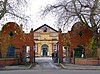
 / 53.56085; -1.18852 (Miners' Welfare Institute)
Woodlands, Doncaster - geograph.org.uk - 1078336.jpg
1924The building is in red brick, partly rendered, with faience dressings and Welsh slate roofs. There is a single storey and a front of nine bays. It has a moulded plinth, a sill band, corner pilasters, and a moulded entablature. In the centre is an arch with a moulded keystone and ornate spandrels, flanked by panels, and with a parapet containing a sunken inscribed and dated panel. Along the top of the building are piers, with wrought iron railings between them. [37] II

Related Research Articles

<span class="mw-page-title-main">Woodlands, South Yorkshire</span> Model village in South Yorkshire, England

Woodlands is a model village 4 miles (6 km) north-west of Doncaster in South Yorkshire, England. The village lies adjacent to Highfields and Adwick le Street within the City of Doncaster. The colliery village was designed and built in the early 20th century by the architect Percy Houfton as tied cottages for the miners of the neighbouring Brodsworth Colliery. In an era of model villages such as Saltaire, Port Sunlight and Bournville, Woodlands, with extensive open spaces, many different designs of houses, and overall living conditions excellent for their time, possibly represents the height of the model village movement. The village is a conservation area.

Croston is a civil parish in the Borough of Chorley, Lancashire, England. The parish contains 47 buildings that are recorded in the National Heritage List for England as designated listed buildings. Of these, one is listed at Grade II*, the middle grade, and the others are at Grade II, the lowest grade. The parish contains the village of Croston, and this is surrounded by agricultural land. Passing through the parish are the River Yarrow and the new cut of the River Douglas. Most of the listed buildings are farmhouses, farm buildings, and houses, some of which originated as farmhouses. The other listed buildings include churches, almshouses, a village cross, public houses, a school, bridges, a former rectory and associated structures, and a telephone kiosk.

Clitheroe is a civil parish in Ribble Valley, Lancashire, England. It contains 117 listed buildings that are recorded in the National Heritage List for England. Of these, one is listed at Grade I, the highest of the three grades, one is at Grade II*, the middle grade, and the others are at Grade II, the lowest grade.

Rochdale is a town in the Metropolitan Borough of Rochdale, Greater Manchester, England, and it is unparished. The town and the surrounding countryside contain 139 listed buildings that are recorded in the National Heritage List for England. Of these, four are listed at Grade I, the highest of the three grades, four are at Grade II*, the middle grade, and the others are at Grade II, the lowest grade.

Elland is a town and an unparished area in the metropolitan borough of Calderdale, West Yorkshire, England. Elland ward contains 47 listed buildings that are recorded in the National Heritage List for England. Of these, two are listed at Grade I, the highest of the three grades, two are at Grade II*, the middle grade, and the others are at Grade II, the lowest grade. The ward contains the town of Elland, the hamlet of Blackley, and the surrounding area. The Calder and Hebble Navigation passes through the area, and the listed buildings associated with this are locks, a bridge, a milepost, a lock keeper's house, a warehouse, and an office. The other listed buildings include houses and cottages, churches and associated structures, public houses, a barn, a set of stocks, a mill warehouse, four milestones, a former town hall, a former bank, a war memorial, and two telephone kiosks.

Sowerby Bridge is a market town and a ward to the southwest of Halifax in the metropolitan borough of Calderdale, West Yorkshire, England. It contains 67 listed buildings that are recorded in the National Heritage List for England. Of these, three are at Grade II*, the middle of the three grades, and the others are at Grade II, the lowest grade. The ward contains the town of Sowerby Bridge, the smaller settlement of Friendly, and the surrounding area. Industries developed in the area from the later 18th century following the building of the Calder and Hebble Navigation and the Rochdale Canal. Most of the industrial buildings have gone, but some mills remain that have been converted for other uses and are listed. In addition to the canals, the River Calder and the River Ryburn run through the area, and the listed buildings associated with these waterways are bridges, locks, warehouses, and other structures. The other listed buildings include houses and associated structures, road and railway bridges, shops, civic buildings, churches and associated structures, a former Sunday school, farmhouses and farm buildings, a milepost, a milestone, public houses and hotels, and a folly in the form of a tower.

Halifax is a town in the metropolitan borough of Calderdale, West Yorkshire, England. It contains 254 listed buildings that are recorded in the National Heritage List for England. Of these, three are listed at Grade I, the highest of the three grades, 31 are at Grade II*, the middle grade, and the others are at Grade II, the lowest grade. The main industry of the town has been its cloth trade, which dates back to the 14th century, and grew particularly during the 19th century when the town increased considerably in size and prosperity. Of the listed buildings, there are relatively few dating from before the middle of the 18th century, with the great majority dating from between about 1825 and the end of the 19th century. There are many survivors from the cloth industry, especially mills that have been converted for other uses, particularly in the area of Dean Clough. A number of these former mills and associated structures are listed.

Batley is a town and an unparished area in the metropolitan borough of Kirklees, West Yorkshire, England. It contains 63 listed buildings that are recorded in the National Heritage List for England. Of these, one is listed at Grade I, the highest of the three grades, two are at Grade II*, the middle grade, and the others are at Grade II, the lowest grade. Included in the list are the districts of Brown Hill, Carlinghow, Staincliffe and Upper Batley. During the 19th century, Batley became "Queen of the West Riding shoddy towns", shoddy being the process of breaking down rags and waste fabric to be re-used in the manufacture of uniforms. The listed buildings remaining from this industry include a group of three-storey warehouses and showrooms in Station Road. The other listed buildings include houses, cottages and associated structures, churches and items in churchyards, a milestone and boundary stones, a former watermill, a railway viaduct and subways, schools, civic buildings, banks, structures in the cemetery, a museum, a war memorial, and a pair of telephone kiosks.

Dalton is a ward of Huddersfield in the metropolitan borough of Kirklees, West Yorkshire, England. It contains 44 listed buildings that are recorded in the National Heritage List for England. All the listed buildings are designated at Grade II, the lowest of the three grades, which is applied to "buildings of national importance and special interest". The ward is to the east and the northeast of the centre of Huddersfield. The southern part of the ward is mainly residential, the eastern part is mainly industrial, and to the west and north are areas of countryside. The Huddersfield Broad Canal runs along the eastern part, and the listed buildings associated with it are locks, bridges and a warehouse. Most of the listed buildings in the residential parts are houses, cottages, shops and associated structures, and in the countryside they are farmhouses and farm buildings. The other listed buildings include churches and related structures, the remains of a hypocaust and a former cloth hall re-erected in a park, a road bridge, mill buildings and a mill chimney.

Greenhead is a ward of Huddersfield in the metropolitan borough of Kirklees, West Yorkshire, England. It contains 258 listed buildings that are recorded in the National Heritage List for England. Of these, four are listed at Grade II*, the middle of the three grades, and the others are at Grade II, the lowest grade. The ward is to the west and north of the centre of town of Huddersfield, it is mainly residential, and includes the districts and suburbs of Birkby, Edgerton, Fartown, Gledholt, Highfields, Hillhouse, Longwood, Marsh, Paddock, and Thornton Lodge.

Newsome is a ward of Huddersfield in the metropolitan borough of Kirklees, West Yorkshire, England. It contains over 430 listed buildings that are recorded in the National Heritage List for England. Of these, one is listed at Grade I, the highest of the three grades, 16 are at Grade II*, the middle grade, and the others are at Grade II, the lowest grade. The ward is large, and contains the centre of the town of Huddersfield, and areas to the west and south. This list contains the listed buildings outside the centre of the town, namely those outside the ring road, and include the areas of Almondbury, Armitage Bridge, Aspley, Highfields, Lockwood, Longley, Lowerhouses, Moldgreen, Newsome, Rashcliffe, Springwood, and Taylor Hill. The listed buildings in the central area within the ring road are at Listed buildings in Huddersfield

Northowram is in the ward of Northowram and Shelf in the metropolitan borough of Calderdale, West Yorkshire, England. It contains 32 listed buildings that are recorded in the National Heritage List for England. Of these, five are at Grade II*, the middle of the three grades, and the others are at Grade II, the lowest grade. The ward contains the village of Northowram, and areas to the west extending to the eastern boundary of Halifax, and includes the settlements of Shibden, Stump Cross and Claremount. Most of the listed buildings are houses, cottages and associated structures, farmhouses, and farm buildings. The other listed buildings include churches, a public house, an underground bath house, a slab wall, a former textile mill converted into flats, and a boundary stone.

Crigglestone is a civil parish in the metropolitan borough of the City of Wakefield, West Yorkshire, England. The parish contains 20 listed buildings that are recorded in the National Heritage List for England. Of these, one is listed at Grade II*, the middle of the three grades, and the others are at Grade II, the lowest grade. The parish is mainly residential, and most of the listed buildings are houses, farmhouses and farm buildings. The other listed buildings consist of two churches, a former corn mill, and a milestone.

Wakefield is a city in the metropolitan borough of the City of Wakefield, West Yorkshire, England. In the city and surrounding area are 190 listed buildings that are recorded in the National Heritage List for England. Of these, seven are listed at Grade I, the highest of the three grades, 18 are at Grade II*, the middle grade, and the others are at Grade II, the lowest grade. Historically a market town, it was the chief wool market in Yorkshire in the 18th century, and in the 19th century the cattle market was the largest in the north of England. The prosperity from this is reflected in the size of the parish church, and in the large number of fine Georgian houses, many of which are listed.

Central ward is a ward in the metropolitan borough of Barnsley, South Yorkshire, England. The ward contains 48 listed buildings that are recorded in the National Heritage List for England. Of these, three are listed at Grade II*, the middle of the three grades, and the others are at Grade II, the lowest grade. The ward is in the central part of the town of Barnsley, a market town until the coming of the Industrial Revolution. Its main industry was wire-drawing, and it later became the centre of English linen weaving. However, later developments in the town has led to the destruction of many of its older buildings.

Hoyland Milton is a ward in the metropolitan borough of Barnsley, South Yorkshire, England. The ward contains 35 listed buildings that are recorded in the National Heritage List for England. Of these, eleven are listed at Grade II*, the middle of the three grades, and the others are at Grade II, the lowest grade. The ward contains the villages of Elsecar and Hemingfield and the surrounding area. Elsecar is located beside former industrial enterprises, including collieries and the Elsecar Ironworks. A high proportion of the listed buildings are associated with the ironworks, which have since been used for other purposes, some of the buildings forming the basis for the Elsecar Heritage Centre. The Elsecar branch of the Dearne and Dove Canal, now disused, passes through the ward, and two structures associated with it are listed, a canal basin and a bridge. The other listed buildings in the village include houses and cottages, a church, a school, a market hall later used as an assembly hall, and a former flour mill. Associated with the collieries are a former pumping engine house, and the entrance to a coal mine. Outside the village are listed farmhouses and farm buildings.

Adwick upon Dearne is a civil parish in the metropolitan borough of Doncaster, South Yorkshire, England. The parish contains seven listed buildings that are recorded in the National Heritage List for England. Of these, one is listed at Grade II*, the middle of the three grades, and the others are at Grade II, the lowest grade. The parish contains the village of Adwick upon Dearne and the surrounding countryside. The listed buildings consist of a church, a cross base in the churchyard, a dovecote, two bridges, and a farmhouse.

Bentley is a ward in the metropolitan borough of Doncaster, South Yorkshire, England. The ward contains 22 listed buildings that are recorded in the National Heritage List for England. Of these, one is listed at Grade I, the highest of the three grades, and the others are at Grade II, the lowest grade. The ward contains the suburb of Bentley, the villages of Almholme, Arksey, and Toll Bar, and the surrounding area. There is a group of listed buildings in Arksey, including the church, the vicarage, the former school and its wall, a group of almshouses, a hall, and a pinfold. Elsewhere, the listed buildings include another church, another pinfold, houses and cottages, a former watermill, farmhouses and farm buildings, a road causeway, a road bridge, and four mileposts.

Fishlake is a civil parish in the metropolitan borough of Doncaster, South Yorkshire, England. The parish contains 13 listed buildings that are recorded in the National Heritage List for England. Of these, one is listed at Grade I, the highest of the three grades, and the others are at Grade II, the lowest grade. The parish contains the village of Fishlake and the surrounding area. The listed buildings include a church, the remains of two medieval crosses, houses and cottages, a farmhouse, farm buildings, two former windmills, a road bridge, and a pinfold.

Thorne is a civil parish in the metropolitan borough of Doncaster, South Yorkshire, England. The parish contains 23 listed buildings that are recorded in the National Heritage List for England. Of these, one is listed at Grade I, the highest of the three grades, and the others are at Grade II, the lowest grade. The parish contains the town of Thorne, the village of Moorends, and the surrounding countryside. Most of the listed buildings are houses and associated structures, and farmhouses. The other listed buildings include a church, a coffin in the churchyard, a public house, a former windmill, a river wharf, two war memorials, and a former charity school.

References

Citations

Sources