Burton is an unparished district in the Wirral Peninsula, Cheshire West and Chester, England. It contains 33 buildings that are recorded in the National Heritage List for England as designated listed buildings. The district contains the village of Burton and surrounding farmland and marsh. Most of the listed buildings are houses and cottages in the village, and many of these date from the 17th century, although most have been altered or extended. Only one of the buildings is listed at Grade II*, the middle of the three grades; this is St Nicholas' Church. All the other buildings are listed at Grade II, the lowest grade. The major house in the village is Burton Manor, which was later converted into an adult education college, although this closed in 2011. There are separate listed structures associated with the church and the manor. The other buildings include farmhouses and farm buildings, a former school and schoolmaster's cottage, the ruins of a windmill, a peace memorial, and a telephone kiosk.
Grade | Criteria [1] |
---|---|
II* | Particularly important buildings of more than special interest. |
II | Buildings of national importance and special interest. |
Name and location | Photograph | Date | Notes | Grade |
---|---|---|---|---|
Barn End 53°15′38″N3°01′40″W / 53.2605°N 3.0279°W | 17th century (or earlier) | Originating as two cottages, the building has been altered and converted into one house. It is built partly in timber framing with brick nogging and crucks, and partly in sandstone, all of which is rendered. The house stands on an outcrop of sandstone, and is approached by ten steps. Its roof is thatched. The house is in a single storey and extends for five bays. The windows are horizontal sliding sashes. [2] [3] | II | |
Bishop Wilson's House 53°15′38″N3°01′46″W / 53.2605°N 3.0295°W | Early 17th century | This originated as a cottage, dairy and cheese room; it was altered in the 19th and 20th centuries and is used as a house with an outbuilding. It is built in sandstone. The house has a thatched roof, and the roof of the outbuilding is slated. The house is in a single storey with an attic and has a four-bay front. Above the entrance is a gabled half-dormer, and the attic window is a dormer. Inside the house are the remains of three crucks. The house was the birthplace of Bishop Wilson. [2] [4] | II | |
Barn Farmhouse and outbuildings 53°15′21″N3°01′22″W / 53.2557°N 3.0229°W | — | 17th century | The farmhouse and outbuildings are in stone and brick with slate roofs, the front of the farmhouse being stuccoed. The farmhouse is in two storeys with a two-bay front on a stone plinth and the outbuildings are in a single storey with a loft. The windows are a mix of sashes and casements. [5] | II |
Burton Point Farmhouse 53°15′35″N3°02′37″W / 53.2597°N 3.0435°W | — | 17th century | There have been alterations and additions, and the farmhouse is used as a house. It is built in sandstone with some rendering, and has a slate roof with stone copings and ridges. The house is in two storeys and has two bays. The windows are later casements. [6] | II |
Church Cottage 53°15′41″N3°01′27″W / 53.2613°N 3.0243°W | — | 17th century | Originally two cottages, this has been converted into a single dwelling. It is built in sandstone and brick with a slate roof. The house is in two storeys and has a five-bay front, with the left (brick) part standing on a stone plinth. The windows are casements. [7] | II |
Elm Farmhouse 53°15′38″N3°01′32″W / 53.2606°N 3.0256°W | — | 17th century | The farmhouse was remodelled in the 19th century and extended in the 20th century, and is used as a private house. It is built in stone and brick on a stone plinth and has a slate roof. The house is in two storeys with an attic, and has a three-bay front with an added bay to the right. The windows are casements. Inside the house is an inglenook. [8] | II |
Farm building, Village Street 53°15′39″N3°01′36″W / 53.2607°N 3.0268°W | — | 17th century | The farm building has subsequently been altered. It is in sandstone with a slate roof. The building has one storey and a loft and extends for two bays. Its features include two large circular pitch holes. [9] | II |
Greenwood 53°15′37″N3°01′47″W / 53.2603°N 3.0298°W | — | 17th century | This originated as a house and a farm building, and was later combined into a single dwelling. It was damaged by fire in the 20th century. The building is timber-framed and encased in brick, and has a red tiled roof. It has an L-shaped plan, is in a single storey, and in two bays. The windows are replacement casements. [10] | II |
Plessington Cottage 53°15′40″N3°01′32″W / 53.2610°N 3.0255°W | 17th century | The house has been altered and extended. It is built in roughcast brick with a slate roof. The original part is in a single storey with attics and two dormers, and has a three-bay front. The extension to the left has two storeys and a single bay. The windows are replacement casements. The house stands on a sandstone outcrop, and steps lead up to the entrance. [11] | II | |
Rake Farm Cottage 53°15′37″N3°01′43″W / 53.26034°N 3.02865°W | 17th century | The house has been altered, and it was restored in about 1975. It is basically timber-framed on a sandstone plinth, and was later encased in brick. The house is in two storeys and has a two-bay front. In the plinth is a blocked mullioned window. Four steps lead up to the door. The windows are replacement casements. [12] | II | |
Rose Cottage 53°15′37″N3°01′38″W / 53.26028°N 3.02726°W | — | 17th century | A house that was altered in the 19th and 20th centuries. It is partly timber-framed with brick nogging, and partly in stone. The house has a single storey with an attic and a two-bay front. The left part projects slightly forward and contains a door. The windows are 20th-century casements; those in the attic are in gabled half-dormers. [13] | II |
The Croft 53°15′37″N3°01′44″W / 53.26037°N 3.02880°W | — | 17th century | The end cottage in a row of three. It is built in roughcast sandstone with a slate roof and a tile ridge. It is in a single storey with an attic, and has a front with one window and a door. The door is approached by six steps. The windows are replacement casements; that in the attic is in a gabled half-dormer. [14] | II |
Church House 53°15′37″N3°01′38″W / 53.2604°N 3.0273°W | — | Late 17th century | Originating as two cottages, there have been alterations in the 19th and 20th centuries, and it is now a single dwelling with an L-shaped plan. The building is timber-framed with crucks and brick nogging on a stone plinth. It is roofed in red tiles, with gables, one coped, the other with bargeboards. The building is in one storey with attics. The windows are later casements. [15] | II |
Delamere House 53°15′38″N3°01′37″W / 53.2605°N 3.0269°W | — | Late 17th century | This is basically a timber-framed house with crucks, which was later altered and encased in rendered sandstone. The house has a stone plinth and a red tiled roof. It is in a single storey with an attic, and has a two-bay front. The windows are casements; that in the attic being in a half-dormer. [16] | II |
Pickerton Cottage 53°15′38″N3°01′37″W / 53.2606°N 3.0270°W | — | Late 17th century | A sandstone house with a slate roof and stone copings. It is in two storeys, and has a three-bay front. The windows are mainly replacement casements. [17] | II |
Stanley House 53°15′38″N3°01′38″W / 53.2606°N 3.0272°W | — | Late 17th century | The house was extended in the late 18th century, and altered in the 20th century. The original house is timber-framed with brick nogging on a sandstone plinth, and has a red tile roof. The extension to the left is in stone and has a slate roof. The original part has a single storey with an attic, and is in two bays. The extension has two storeys and one bay. The windows in the original part are 20th-century casements, those in the attic being in gabled dormers; the windows in the extension are sashes. [18] | II |
The White House 53°15′38″N3°01′35″W / 53.2605°N 3.0263°W | — | Late 17th century | This originated as a farmhouse, later altered into a house with a shop, then into a private house. It is built in painted brick on a stone plinth with a slate roof. It is in two storeys with a four-bay front. Most of the windows are 19th-century casements. [19] | II |
Church Farmhouse 53°15′39″N3°01′31″W / 53.2608°N 3.0253°W | — | 1678 | This originated as a farmhouse with an attached cottage, and was later converted into a single dwelling. The house is in brick with stone quoins on a stone plinth. The former cottage is rendered. Both have slate roofs. Both parts are in two storeys, the house having two bays, and the cottage having one. The windows are sashes. [20] | II |
Peartree Cottage 53°15′40″N3°01′33″W / 53.2610°N 3.0258°W | — | 1682 | The cottage is built in sandstone and brick, and has a slate roof with red ridge tiles. It is in a single storey with a three-bay front, and a single-bay lean-to extension to the left. The windows are casements. [21] | II |
St Nicholas House 53°15′37″N3°01′39″W / 53.2603°N 3.0275°W | — | 1711 | The house has been altered and extended. It is built in roughcast brick and has slate roofs. The main part has three storeys and a four-bay front, and the extension to the right has two storeys and one bay. The windows in the main part of the house are sashes, and in the extension and the porch they are casements. [22] | II |
St Nicholas' Church 53°15′42″N3°01′30″W / 53.2617°N 3.0250°W | 1721 | The church incorporates a chapel dating from 1380, and the chancel was rebuilt in 1870. It is built in sandstone and has a slate roof. The church consists of a continuous nave and chancel, a north aisle, a north vestry and a west tower. The tower is in four stages and has a plain parapet and a clock face, the clock having only one hand. [23] [24] [25] | II* | |
The Old School 53°15′41″N3°01′56″W / 53.2614°N 3.0323°W | — | 1724 | This originated as a school with an attached schoolmaster's cottage. A rear extension was added in 1890, and the building has been converted into a residence. It is built in brick with a slate roof and coped gables. The School is in a single storey with a five-bay front, the end bays being gabled and projecting forwards, The cottage is in one storey and an attic, and has one bay. [26] | II |
Chest tombs 53°15′41″N3°01′29″W / 53.2615°N 3.0248°W | 1740–83 | A group of 18 chest tombs in the churchyard of St Nicholas. They are in sandstone and have various inscriptions. Many of these consist of indecipherable dates and names, but skull and crossbones and hourglass motifs can be identified. [2] [27] | II | |
Barn, Burton Marsh Farm 53°15′41″N3°02′50″W / 53.2615°N 3.0471°W | — | Mid 18th century | The barn is built in sandstone with a slate roof and coped gables. It is in two storeys, including lofts, and has a four-bay front. Its features include round pitch holes and vertical slit ventilators. [28] | II |
Sundial 53°15′42″N3°01′30″W / 53.26154°N 3.02500°W | — | 18th century | The sundial is in the churchyard of St Nicholas. It is constructed in red sandstone and consists of a vase-shaped pillar on a square pedestal, standing on square base. The dial and gnomon are missing. [2] [29] | II |
Windmill (remains) 53°15′46″N3°01′53″W / 53.26284°N 3.03132°W | — | 1771 | This was a tower windmill with a circular plan. It is built in sandstone, but only the lower eight courses and a date stone have survived. [30] | II |
Grave slabs 53°15′42″N3°01′29″W / 53.2616°N 3.0248°W | — | 1783–1879 | A group of eight grave slabs in the churchyard of St Nicholas. They are in sandstone and have various inscriptions, many of which consist of indecipherable dates and names. [31] | II |
Burton Manor 53°15′35″N3°01′43″W / 53.2597°N 3.0285°W | c. 1805 | A house that was remodelled in 1902–05 by Sir Charles Nicholson, with an orangery added in 1910. In 1948 it became an adult education college, but this closed in 2011. The house is built in sandstone with a green slate roof, and has a quadrilateral plan with a central courtyard. The entrance front is in two and three storeys and five bays, the central bay having an open pediment. The windows in the house and the orangery are sashes, and there is also a high-level Diocletian window in the orangery. [2] [32] [33] [34] | II | |
Ice House, Burton Manor 53°15′33″N3°01′47″W / 53.25906°N 3.02984°W | c. 1805 | The ice house is constructed in sandstone. It consists of two underground chambers linked by a passage, each chamber being approached by a separate flight of steps. [35] | II | |
Coach House, Burton Manor 53°15′36″N3°01′44″W / 53.2601°N 3.0288°W | — | 1904 | The coach house was designed by Sir Charles Nicholson and converted into a house in 1948. It is built in sandstone and has a roof of Westmorland slate. The house is in a single storey with attics, and has a front of three bays. On the roof are weatherboarded dormers, and a slate-clad clock tower with a pyramidal roof, and a weathervane in the form of a bird. [2] [36] | II |
Wall, gate piers and library, Burton Manor 53°15′37″N3°01′44″W / 53.26026°N 3.02896°W | — | 1904 | Designed by Sir Charles Nicholson, parts of the sandstone wall probably pre-date his design. The library is in sandstone with a hipped slate roof. It is in a single storey with three bays, and a flat-roofed extension to the right. The gate piers are in brick, standing in pairs on each side of the entrance. They have ball finials, and the pairs of piers are joined by stone lintels. [37] | II |
Burton in Wirral Peace Cross 53°15′45″N3°01′21″W / 53.26257°N 3.02263°W | — | 1917 | The memorial stands near a road junction. It is in stone, and consists of a wheel-head cross on a tall four-sided plinth on a base of three steps. There are inscriptions on the three steps including a plea for peace. [38] | II |
Telephone kiosk 53°15′38″N3°01′39″W / 53.26043°N 3.02740°W | — | 1935 | A K6 type telephone kiosk, designed by Giles Gilbert Scott. It is constructed in cast iron, with a square plan and domed roof. In the panels around the top are three unperforated crowns. [39] | II |
A total of 21 buildings and other structures in the English civil parish of Dodcott cum Wilkesley have been officially designated as listed buildings for their "special architectural and historic interest". Dodcott cum Wilkesley is in the Cheshire East division of the ceremonial county of Cheshire, situated on the Cheshire Plain at the border with Shropshire. The civil parish is predominantly rural, with many scattered minor settlements, the largest of which is the small village of Burleydam. One of the listed buildings is classified by English Heritage as being in grade I, meaning "of exceptional interest, sometimes considered to be internationally important" ; two are in grade II* and the remainder in grade II.
Kingsley is a civil parish in Cheshire West and Chester, England. Other than the village of Kingsley, the parish is entirely rural. It contains 13 buildings that are recorded in the National Heritage List for England as designated listed buildings. Other than the church and its lychgate, and the wall of a former Quaker burial ground, the structures are all related to domestic buildings or farms.
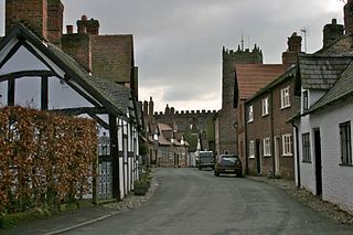
Great Budworth is a civil parish in Cheshire West and Chester, England. The parish contains 59 buildings that are recorded in the National Heritage List for England as designated listed buildings. Other than the village of Great Budworth, the parish is entirely rural. Most of the listed buildings are houses, or buildings relating to farming, a high proportion of which are located within the village itself. The village is described by Norman Bilsborough as being "probably one of the best-known villages in Cheshire", and Claire Hartwell et al. writing about the village in the Buildings of England series state "the immediate surroundings of the church make one of the best pieces of villagescape in the county". The village is located in what was part of the estate of Arley Hall. Between the 1860s and the end of the 19th century the owner of the hall, Rowland Egerton-Warburton, commissioned the restoration of existing buildings in the village and the construction of new ones. To this end he employed architects working in the Vernacular Revival style, including John Douglas, Edmund Kirby, and William Eden Nesfield. Douglas' biographer Edward Hubbard states that Egerton-Warburton had a "campaign to restore the village and render it picturesque in Victorian eyes". Almost all the buildings in the centre of the village, those in Main Street, Church Street, and School Lane, are listed.
Ince is a civil parish in Cheshire West and Chester, England. It contains 25 buildings that are recorded in the National Heritage List for England as designated listed buildings. One is these is of these listed at Grade I, the highest grade, one at Grade II*, the middle grade, and the rest are at the lowest grade, Grade II.
Neston is a civil parish in Cheshire West and Chester, England. It contains 76 buildings that are recorded in the National Heritage List for England as designated listed buildings. Of these, five are listed at Grade II*, the middle grade, and the others are at Grade II. In addition to the village of Neston, it contains the settlements of Parkgate, Little Neston, and Ness. Outside the villages, the parish is rural. Most of the listed buildings are houses, or related to farming. The other listed buildings include churches and associated structures, a public house, a converted windmill, a former school and its chapel, a bridge over a disused railway, a war memorial, and a telephone kiosk.
There are over 20,000 Grade II* listed buildings in England. This page is a list of these buildings in the unitary authority of Cheshire West and Chester.
Shotwick is a former civil parish, now in the parish of Puddington, in Cheshire West and Chester, England. It contains 23 buildings that are recorded in the National Heritage List for England as designated listed buildings. Of these, one is listed at Grade I, the highest grade, two are listed at Grade II*, the middle grade, and the others are at Grade II. Apart from the village of Shotwick, the parish is entirely rural. Most of the listed buildings are in the village, and include houses, St Michael's Church and structures in the churchyard, and Shotwick Hall with associated structures. Outside the village, the listed buildings are domestic or related to farming.
Tattenhall is a former civil parish, now in the parish of Tattenhall and District, in Cheshire West and Chester, England. It contains 27 buildings that are recorded in the National Heritage List for England as designated listed buildings. Of these, three are listed at Grade II*, the middle grade, and the others are at Grade II, the lowest grade. Apart from the village of Tattenhall, the parish is rural. In the village the listed buildings include the church and its sundial, the war memorial, and houses and cottages, some dating from the 17th century and with a timber-framed core. Outside the village, the listed buildings include country houses and associated structures, other houses and cottages, farmhouses, and a boundary stone.
Wimbolds Trafford is a former civil parish, now in the parish of Mickle Trafford and District, in Cheshire West and Chester, England. It contains five buildings that are recorded in the National Heritage List for England as designated listed buildings. Of these, one is listed at Grade II*, the middle grade, and the others are at Grade II. The parish is entirely rural. Its listed buildings consist of a former country house and its lodge, a cottage, a farmhouse, and farm buildings.
Acton is a civil parish in Cheshire East, England. It contains 24 buildings that are recorded in the National Heritage List for England as designated listed buildings. Of these, two are listed at Grade I, the highest grade, four are listed at Grade II*, the middle grade, and the others are at Grade II. Apart from the village of Acton, the parish is rural. Listed buildings in the village include the church and associated structures, houses, a public house and a telephone kiosk. The major structure is the parish is Dorfold Hall; this and associated structures are listed. The other items include an aqueduct carrying the Shropshire Union Canal across a road, farmhouses and cottages.
Alderley Edge is a civil parish in Cheshire East, England. It contains 30 buildings that are recorded in the National Heritage List for England as designated listed buildings. Of these, one is listed at Grade I, the highest grade, one is listed at Grade II*, the middle grade, and the others are at Grade II. The parish contains the village of Alderley Edge, which became a dormitory settlement for workers in Manchester following the arrival of the railway in 1842. Included in the listed buildings are mansions for the more wealthy businessmen. In the countryside surrounding the village are listed houses, cottages, and farm buildings. Within the village, in addition to houses, the listed buildings include a former railway hotel, churches, a school, a bank, a drinking fountain, a war memorial, and a garage.
Audlem is a civil parish in Cheshire East, England. It contains 25 buildings that are recorded in the National Heritage List for England as designated listed buildings. Of these, two are listed at Grade I, the highest grade, one is listed at Grade II*, the middle grade, and the others are at Grade II. The major settlement in the parish is the village of Audlem. In the village the listed buildings include churches and cemetery chapels, a former grammar school, a hotel, houses, and a memorial lamp standard. In the surrounding countryside the listed buildings include country houses, farmhouses, farm buildings, and a road bridge. Running through the parish is the Shropshire Union Canal, and the listed structures associated with this are bridges, mileposts and a lock keeper's cottage.
Brereton is a civil parish in Cheshire East, England. It contains 21 buildings that are recorded in the National Heritage List for England as designated listed buildings. Of these, one is listed at Grade I, the highest grade, three are listed at Grade II*, the middle grade, and the others are at Grade II. The parish is almost entirely rural. The major building in the parish is Brereton Hall. The listed buildings consist of the hall and associated buildings, the church and a sundial in its churchyard, a public house, a former mill, farmhouses and farm buildings, houses or cottages, and three mileposts.
Chelford is a civil parish in Cheshire East, England. It contains nine buildings that are recorded in the National Heritage List for England as designated listed buildings. Of these, three are listed at Grade II*, the middle grade, and the other six are at Grade II. Apart from the village of Chelford, which is in the western part of the parish, to the west of the railway, and well to the west of the Chelford Roundabout, where the A535 road meets the A537. The listed buildings are to the south and east of the roundabout. Most of them are houses and cottages, the other listed buildings being farm buildings, a church and a bridge.
Cranage is a civil parish in Cheshire East, England. It contains 12 buildings that are recorded in the National Heritage List for England as designated listed buildings. Of these, one is listed at Grade II*, the middle grade, and the others are at Grade II. Apart from the village of Cranage, and some residential areas, the parish is rural. Most of the listed buildings are houses and cottages, or farmhouses and farm buildings. The other listed buildings are a former country house, a former vicarage, a school, a bridge, and a milepost.
Goostrey is a civil parish in Cheshire East, England. It contains 19 buildings that are recorded in the National Heritage List for England as designated listed buildings. Of these, one is listed at Grade I, the highest grade, three are listed at Grade II*, the middle grade, and the others are at Grade II. Apart from the village of Goostrey, the parish is mainly rural. It contains the Jodrell Bank Observatory, with its Grade I listed Lovell Telescope and its control building. In the village, the listed buildings include the church and associated structures, the former schoolmaster's house, and a row of cottages. Outside the village they include country houses, farmhouses, and farm buildings, some of which date back to the 16th century and are timber-framed.
Mobberley is a civil parish in Cheshire East, England. It contains 43 buildings that are recorded in the National Heritage List for England as designated listed buildings. Of these, one is listed at Grade I, the highest grade, three are listed at Grade II*, the middle grade, and the others are at Grade II. Other than the village of Mobberley, and part of the runways of Manchester Airport, the parish is rural. The listed buildings are what would be expected in such an area, namely country houses and associated structures, farmhouses and farm buildings, smaller houses and cottages, and a church with associated structures.
Over Alderley is a civil parish in Cheshire East, England. It contains 25 buildings that are recorded in the National Heritage List for England as designated listed buildings. Of these, three are listed at Grade II*, the middle grade, and the others are at Grade II. Other than the village of Ollerton, the parish is mainly rural. Apart from a church and three parish boundary stones, the listed buildings are all houses, farmhouses, and associated structures.
Prestbury is a civil parish in Cheshire East, England. It contains 51 buildings that are recorded in the National Heritage List for England as designated listed buildings. Of these, one is listed at Grade I, the highest grade, three are listed at Grade II*, the middle grade, and the others are at Grade II. Many of the listed buildings are in the village of Prestbury, including houses, a church and associated structures, shops, a bank, hotels, a public house, the village stocks, the entrance to a railway tunnel, and a telephone kiosk. In the surrounding countryside the listed buildings are more houses, farms and farm buildings, parish boundary stones, an ancient cross, and mileposts.
Wilmslow is a town and civil parish in Cheshire East, England. The area, including the parishes of Handforth and Styal, contains 81 buildings that are recorded in the National Heritage List for England as designated listed buildings. Of these, one is listed at Grade I, the highest grade, eight are listed at Grade II*, the middle grade, and the others are at Grade II. The town has grown from a village to encompass some of the surrounding settlements to become a dormitory town for Manchester. Buildings listed within the town include the church and associated structures, a bridge, and former weavers' cottages. Also in the area is the village of Styal that was developed to house the workers at Quarry Bank Mill. The mill, associated structures, and many of the cottages in the village are listed. Elsewhere the listed buildings include country houses and associated structures, farms and farm buildings, bridges, public houses, chapels, and a viaduct.
Citations
Sources