Listed buildings in Darley Dale

Last updated

Darley Dale is a civil parish in the Derbyshire Dales district of Derbyshire, England. The parish contains 27 listed buildings that are recorded in the National Heritage List for England. Of these, three are listed at Grade II*, the middle of the three grades, and the others are at Grade II, the lowest grade. The parish contains the town of Darley Dale and the surrounding area. Most of the listed buildings are houses, cottages and associated structures, farmhouses and farm buildings. The other listed buildings include a church and its former rectory, a road bridge over the River Derwent, public houses, a mile post and a milestone, buildings associated with Darley Dale railway station, an institute, and a school.

Contents

Key

Map all coordinates using: OpenStreetMap  
Download coordinates as: KML
GradeCriteria [1]
II*Particularly important buildings of more than special interest
IIBuildings of national importance and special interest

Buildings

Name and locationPhotographDateNotesGrade
St Helen's Church
53°09′48″N1°36′09″W / 53.16337°N 1.60242°W / 53.16337; -1.60242 (St Helen's Church)
Darley Dale - St. Helen's Church - geograph.org.uk - 961164.jpg
13th centuryThe church, which contains Norman features, has been altered and extended through the centuries, and it was restored in 1854–55. The church consists of a nave, north and south aisles, a south porch, north and south transepts, a chancel, and a west tower. The tower has angle buttresses, a west doorway and window, and an embattled parapet with corner pinnacles. The transepts are also embattled. [2] [3] II*
Darley Bridge
53°09′19″N1°35′49″W / 53.15515°N 1.59696°W / 53.15515; -1.59696 (Darley Bridge)
Darley Bridge.jpg
15th centuryThe bridge carries the B5057 road over the River Derwent. It is in stone, and consists of two pointed arches, each with four ribs, and three semicircular arches. [4] II*
Fir Tree Cottage
53°09′50″N1°34′48″W / 53.16377°N 1.57997°W / 53.16377; -1.57997 (Fir Tree Cottage)
1633The cottage is in stone with a tile roof and two storeys. Most of the mullioned windows have been replaced. The doorway has a chamfered surround, and at its head are carvings, including a trowel and rosettes, an inscription, and the date. [5] II
Outbuilding of Rectory
53°09′48″N1°36′07″W / 53.16328°N 1.60189°W / 53.16328; -1.60189 (Outbuilding of Rectory)
Rectory Farm, Darley Dale.jpg
17th centuryA long stone building with a tile roof and two storeys. It contains a doorway with a chamfered surround, mullioned windows, and three 17th-century inscribed stone panels. [6] II
Stancliffe Hall
53°10′20″N1°36′04″W / 53.17217°N 1.60113°W / 53.17217; -1.60113 (Stancliffe Hall)
1670A large house that was enlarged in 1872, and again in 18779–85 by E. M. Barry. It is in stone with moulded floor bands, pilasters, parapets, and coped gables with ball finials. There are two storeys and attics, and a south front of nine bays. The windows are mullioned and transomed, and some have been altered. On the west is a large porch and a doorway with a moulded and chamfered surround, and carved plinth blocks. [7] [8] II
White House
53°09′49″N1°36′09″W / 53.16357°N 1.60247°W / 53.16357; -1.60247 (White House)
Late 17th century (probable)A stone house with a tile roof and two storeys. The doorway has a plain surround, there is a rustic wooden porch, and the windows are casements with chamfered surrounds. [9] II
The Cottage
53°09′52″N1°35′02″W / 53.16451°N 1.58402°W / 53.16451; -1.58402 (The Cottage)
1704A stone house with moulded eaves, and a roof of slate and tile with gables and kneelers. There are two storeys, two bays, and a wing. The doorway has a chamfered surround, and a slight dentilled cornice, over which is a large moulded panel with rosettes in the spandrels, initials and the date. The windows are mullioned with two lights. [10] II
Square and Compass public house
53°09′21″N1°35′49″W / 53.15579°N 1.59685°W
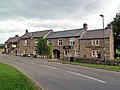
 / 53.15579; -1.59685 (Square and Compass public house)
The Square and Compass - geograph.org.uk - 2633645.jpg
1735The public house is in stone with quoins and a Welsh slate roof. The building is in four sections, all with two storeys, and with different roof heights. The left section contains a doorway with a massive surround and the date. In each of the middle two sections are segmental arches. The windows are a mix of sashes and casements, and on the front of the building is a parish boundary post. [11] II
Cottage, barn and pigsties,
Farley Farm
53°09′21″N1°33′44″W / 53.15587°N 1.56230°W / 53.15587; -1.56230 (Cottage, barn and pigsties, Farley Farm)
18th centuryThe cottage is in stone with quoins, a floor band, and a Welsh slate roof with coped gables and moulded kneelers. There are two storeys and a symmetrical front of three bays. In the centre is a doorway with a moulded cornice, above it is a blocked oval window, and the other windows are mullioned with two lights. Attached to the left is a barn, and further to the left are pigsties. [12] II
Plough Inn
53°09′49″N1°34′53″W / 53.16355°N 1.58148°W / 53.16355; -1.58148 (Plough Inn)
Two Dales - geograph.org.uk - 125312.jpg
1755The public house is in stone and has a tile roof with kneelers. There are two storeys and three bays. The central doorway has a plain surround and a slight moulded cornice, and above it is an initialled and dated panel. The windows are mullioned with two lights and contain sashes. [13] II
Wingate Cottage
53°10′15″N1°35′31″W / 53.17088°N 1.59183°W / 53.17088; -1.59183 (Wingate Cottage)
1770A stone house with quoins, a band, moulded eaves, and a tile roof. There are two storeys and three bays. The central doorway has a quoined surround and a pediment, and above it is a circular dated plaque. In the outer bays are sash windows in architraves, those in the ground floor with double keystones. [14] II
Darley Hall
53°09′53″N1°35′17″W / 53.16464°N 1.58792°W / 53.16464; -1.58792 (Darley Hall)
1796–97A large house that has been altered and later used for other purposes. It is in stone with a parapet and a hipped slate roof. There are three storeys and three bays. On the front is a Roman Doric porch, on the right is an angled bay window, and the other windows are sashes. [7] [15] II
Holt House
53°09′40″N1°34′37″W / 53.16122°N 1.57689°W / 53.16122; -1.57689 (Holt House)
c. 1798A stone house with thin giant Ionic pilasters on the front, a moulded cornice, and a parapet. There are three storeys, the ground floor rusticated, and three bays. In the centre, steps on each side lead up to an entrance in the middle floor with a French window, and below it is a recessed arched entrance to the lower floor. The windows are sashes in moulded architraves. [7] [16] II*
Grouse Inn
53°10′01″N1°35′58″W / 53.16704°N 1.59931°W / 53.16704; -1.59931 (Grouse Inn)
Darley Dale - Grouse Inn - geograph.org.uk - 1943360.jpg
Early 19th centuryThe public house is in stone with a tile roof. There are two storeys and three bays. In the centre is a Tuscan portico with an iron balustrade, and a doorway with a moulded surround and a segmental-headed fanlight. The windows are sashes. [7] [17] II
Milepost
53°09′44″N1°35′22″W / 53.16224°N 1.58933°W / 53.16224; -1.58933 (Milepost)
Old Milepost by the A6, Dale Road North, Darley Dale (geograph 5623828).jpg
Early 19th centuryThe milepost is by a wall on the east side of Dale Road North (A6 road). It is in cast iron with a shaped top, and is inscribed with the distances to London, Bakewell and Matlock. [18] II
Milestone
53°09′02″N1°34′33″W / 53.15047°N 1.57571°W / 53.15047; -1.57571 (Milestone)
Old Milestone by the A6, opposite Whitworth Hospital (geograph 5623827).jpg
Early 19th centuryThe milestone is on the southwest side of Dale Road South (A6 road). It consists of a stone with a triangular section and a sloping top, inscribed with the distances to London, Bakewell and Matlock. [19] II
Sydnope Hall
53°10′22″N1°33′42″W / 53.17282°N 1.56180°W / 53.17282; -1.56180 (Sydnope Hall)
Sydnope Hall.jpg
1826–27The rebuilding of an earlier house in Tudor style, it was further altered in 1865, and has since been converted into flats. It is in stone with embattled parapets and a roof mainly in tiles. There are two storeys, a three-storey tower towards the left, and a long front of ten bays. On the front is a porch with buttresses, and two canted bay windows, all embattled, and the other windows have square hood moulds. [20] [21] II
North building,
Darley Dale railway station
53°09′38″N1°35′38″W / 53.16045°N 1.59393°W / 53.16045; -1.59393 (North building, Darley Dale railway station)
North Building, Darley Dale Station.jpg
c. 1849The station building is in stone with dentilled eaves, and slate roofs with moulded gable copings, kneelers and ball finials. The doorways, which are arched, and the windows, which are mullioned, all have hood moulds extending as bands. [22] [23] II
South building,
Darley Dale railway station
53°09′37″N1°35′40″W / 53.16032°N 1.59433°W / 53.16032; -1.59433 (South building, Darley Dale railway station)
Darley Dale Station.jpg
c. 1849The station building is in stone with dentilled eaves, and slate roofs with moulded gable copings, kneelers and ball finials. Two bays project slightly and are gabled. The doorways, which are arched, and the windows, which are mullioned, all have hood moulds extending as bands. [22] [24] II
Darley Station Houses
53°09′37″N1°35′36″W / 53.16015°N 1.59329°W / 53.16015; -1.59329 (Darley Station Houses)
c. 1849A pair of houses, later combined, designed by Joseph Paxton, they are in stone with a slate roof. There are two storeys and four bays. The windows are casements, those in the ground floor with semicircular heads. [22] [25] II
West Lodge
53°10′06″N1°36′07″W / 53.16840°N 1.60188°W / 53.16840; -1.60188 (West Lodge)
West Lodge, Darley Dale.jpg
c. 1872The house is in stone with a string course, a sill band, a moulded dentilled eaves cornice, and a slate roof, hipped and partly conical, with pinnacles. There are two storeys and attics. At the front is a large semicircular projection with an arcaded frieze between the floors, and a bay to the right. The windows are sashes with architraves, and in the roof are dormers with semicircular moulded stone architraves and finials. On the left return is a large porch with panelled sides, massive corner piers with pediments, and an arched doorway. [26] [27] II
Boundary walls and gate piers, Stancliffe Hall
53°10′20″N1°35′56″W / 53.17220°N 1.59886°W / 53.17220; -1.59886 (Boundary walls and gate piers, Stancliffe Hall)
1870sThe walls are in gritstone with saddleback coping. At the entrance to the drive, they sweep up to monolithic gate piers with caps. [28] II
Boundary walls to former Whitworth Estate (north)
53°10′22″N1°35′57″W / 53.17277°N 1.59927°W / 53.17277; -1.59927 (Boundary walls to former Whitworth Estate (north))
1870sThe walls are in gritstone with saddleback coping. At the curved corners, and at the entrance to the drive, they sweep up to gate piers with caps. In the southwest corner is set a VR post box. [29] II
Boundary walls to former Whitworth Estate (south)
53°10′05″N1°36′00″W / 53.16810°N 1.59988°W / 53.16810; -1.59988 (Boundary walls to former Whitworth Estate (south))
1870sThe walls run in sections along Whitworth Road and Dale Road North, and are in gritstone with saddleback copings. Incorporated in the wall are monolithic gate piers, and a horse trough in a tall arched recess. The arch has rustication voussoirs and a keystone, and at the head of the arch is a massive ashlar semicircular cresting. [30] II
Former Whitworth Hotel
53°09′44″N1°35′24″W / 53.16221°N 1.59012°W / 53.16221; -1.59012 (Former Whitworth Hotel)
Darley Dale - Barrington's.jpg
Late 19th centuryThe building is in stone, and has a roof of green Westmorland slate with gables, kneelers and ball finials. There are two storeys and attics, and three bays, the outer bays projecting and gabled. In the middle bay is a porch, two doorways and a tile roof. Above is a three-light mullioned and transomed window, and in the attic is a dormer with a semicircular pediment. The outer bays have five-light mullioned and transomed windows in the lower two floors, and three-light mullioned windows in the attics. [22] [31] II
Whitworth Institute
53°09′45″N1°35′25″W / 53.16240°N 1.59036°W / 53.16240; -1.59036 (Whitworth Institute)
Darley Dale - Whitworth Institute.jpg
1890The building is in stone, and has a roof of green Westmorland slate with coped gables, kneelers and ball finials. There are two blocks, the left block with two storeys and five bays. In the ground floor is an arcade of five arches, and the upper floor contains mullioned and transomed windows, in the middle and outer bays under gables. On the roof is a cupola. On each side are single-storey links with balustrades, on the right linking with the assembly hall. This has a single storey and three bays, each with a three-light mullioned window and a gablet above. [22] [32] II
Darley Dale Infants School
53°09′33″N1°34′51″W / 53.15913°N 1.58088°W / 53.15913; -1.58088 (Darley Dale Infants School)
Hackney - Greenaway School (Geograph-2067134-by-Dave-Bevis).jpg
1911The school was designed by George Widdows, and is in gritstone with quoins and a mansard roof of Westmorland slate and tile. The front is symmetrical, with six single-storey bays, and a central two-storey bay. The outermost and central bays have half-hipped mansard roofs, and the four intermediate bays contain full-height multi-paned mullioned and transomed windows under catslide roofs. At the rear was an open corridor, which has since been closed. [7] [33] II

Related Research Articles

St Helens Church, Darley Dale Church in Darley Dale, England

St Helen's Church, Darley Dale is a Grade II* listed parish church in the Church of England in Darley Dale, Derbyshire.

Whitworth Institute

The Whitworth Institute is a Grade II listed building in Darley Dale, Derbyshire.

Barrow upon Trent is a civil parish in the South Derbyshire district of Derbyshire, England. The parish contains twelve listed buildings that are recorded in the National Heritage List for England. Of these, one is listed at Grade I, the highest of the three grades, and the others are at Grade II, the lowest grade. The parish contains the villages of Barrow upon Trent and Arleston and the surrounding countryside, and is mainly rural. The listed buildings include houses, two churches, a farmhouse, a bridge over the Trent and Mersey Canal, a former school, and a war memorial.

Baslow and Bubnell is a civil parish in the Derbyshire Dales district of Derbyshire, England. The parish contains 30 listed buildings that are recorded in the National Heritage List for England. Of these, one is listed at Grade I, the highest of the three grades, one is at Grade II*, the middle grade, and the others are at Grade II, the lowest grade. The parish contains the villages of Baslow and Bubnell, and the surrounding countryside and moorland. Most of the listed buildings are houses, cottages and associated structures. The other listed buildings include a church and items in the churchyard, bridges, including a clapper bridge, a hotel, guide posts and guide stones, mile posts and a milestone, a boundary stone, a monument, and a telephone kiosk.

Beeley is a civil parish in the Derbyshire Dales district of Derbyshire, England. The parish contains 20 listed buildings that are recorded in the National Heritage List for England. Of these, three are listed at Grade II*, the middle of the three grades, and the others are at Grade II, the lowest grade. The parish contains the village of Beeley and the surrounding countryside and moorland, mainly to the east of the village. Most of the listed buildings are houses, cottages, and associated structures. The other listed buildings include a church, a public house, a guide post and guide stone, a farmhouse, a converted barn, a former school, and a former vicarage.

Biggin by Hulland is a civil parish in the Derbyshire Dales district of Derbyshire, England. The parish contains eight listed buildings that are recorded in the National Heritage List for England. All the listed buildings are designated at Grade II, the lowest of the three grades, which is applied to "buildings of national importance and special interest". Apart from the village of Biggin by Hulland, the parish is entirely rural, and all the listed buildings are houses or cottages.

Birchover is a civil parish in the Derbyshire Dales district of Derbyshire, England. The parish contains ten listed buildings that are recorded in the National Heritage List for England. Of these, one is listed at Grade II*, the middle of the three grades, and the others are at Grade II, the lowest grade. The parish contains the village of Birchover, and is otherwise rural. The listed buildings consist of houses, cottages and associated structures, a church, a public house, a set of stocks, a milestone, a village well, and a former powder store.

Bonsall is a civil parish in the Derbyshire Dales district of Derbyshire, England. The parish contains 13 listed buildings that are recorded in the National Heritage List for England. Of these, two are listed at Grade II*, the middle of the three grades, and the others are at Grade II, the lowest grade. The parish contains the village of Bonsall and the surrounding area. The listed buildings consist of houses, cottages and associated structures, a farmhouse and an outbuilding, a market cross, two churches, a public house, a sawmill converted for residential use, and a telephone kiosk.

Bradbourne is a civil parish in the Derbyshire Dales district of Derbyshire, England. The parish contains 16 listed buildings that are recorded in the National Heritage List for England. Of these, one is listed at Grade I, the highest of the three grades, one is at Grade II*, the middle grade, and the others are at Grade II, the lowest grade. The parish contains the village of Bradbourne and the surrounding countryside. The listed buildings consist of houses, cottages and associated structures, farmhouses and farm buildings, a church and items in the churchyard, and a former watermill and associated buildings.

Brailsford is a civil parish in the Derbyshire Dales district of Derbyshire, England. The parish contains 35 listed buildings that are recorded in the National Heritage List for England. Of these, one is listed at Grade I, the highest of the three grades, and the others are at Grade II, the lowest grade. The parish contains the village of Brailsford and the hamlet of Ednaston, and the surrounding countryside. Most of the listed buildings are houses, cottages and associated structures, farmhouses and farm buildings. The other listed buildings include a church, a churchyard cross, a watermill, two boundary posts, two mileposts, a bridge, a school, and a well.

Breadsall is a civil parish in the Erewash district of Derbyshire, England. The parish contains ten listed buildings that are recorded in the National Heritage List for England. Of these, one is listed at Grade I, the highest of the three grades, one is at Grade II*, the middle grade, and the others are at Grade II, the lowest grade. The parish contains the village of Breadsall and the surrounding area. The listed buildings consist of houses, cottages and associated structures, a church, and a chapel.

Bretby is a civil parish in the South Derbyshire district of Derbyshire, England. The parish contains 13 listed buildings that are recorded in the National Heritage List for England. Of these, two are listed at Grade II*, the middle of the three grades, and the others are at Grade II, the lowest grade. The parish contains the village of Bretby and the surrounding countryside. The listed buildings include houses, cottages and associated structures, a farmhouse and farm buildings, a church, a former school, a former watermill, a bottle kiln and factory, a war memorial and village pump, and a telephone kiosk.

Calver is a civil parish in the Derbyshire Dales district of Derbyshire, England. The parish contains nine listed buildings that are recorded in the National Heritage List for England. Of these, one is listed at Grade II*, the middle of the three grades, and the others are at Grade II, the lowest grade. The parish contains the village of Calver and the surrounding area. The listed buildings consist of a house, a cottage, a farmhouse, a mounting block and a lamp standard, a bridge, a former schoolroom, a former mill and wheelhouse, and a milestone.

Carsington is a civil parish in the Derbyshire Dales district of Derbyshire, England. The parish contains 18 listed buildings that are recorded in the National Heritage List for England. Of these, one is listed at Grade II*, the middle of the three grades, and the others are at Grade II, the lowest grade. The parish contains the village of Carsington and the surrounding countryside. Most of the listed buildings are houses, cottages, farmhouses and farm buildings, and the others consist of a village cross, a church, a public house, and a school,

Clifton and Compton is a civil parish in the Derbyshire Dales district of Derbyshire, England. The parish contains eight listed buildings that are recorded in the National Heritage List for England. Of these, one is listed at Grade II*, the middle of the three grades, and the others are at Grade II, the lowest grade. The parish contains the villages of Clifton and Hangingbridge, and the surrounding area. The listed buildings consist of houses, cottages and associated structures, a church, its lychgate and wall, a road bridge, and a public house.

Cromford is a civil parish in the Derbyshire Dales district of Derbyshire, England. The parish contains 89 listed buildings that are recorded in the National Heritage List for England. Of these, two are listed at Grade I, the highest of the three grades, seven are at Grade II*, the middle grade, and the others are at Grade II, the lowest grade. The parish contains the village of Cromford and the surrounding area. The parish is important because it was here that Richard Arkwright built the first water-powered mill, and created the "first industrial community of its type in the world". The first workers' houses were built in North Street, and each has three storeys, the top floor being a workshop. There are listed at Grade II*. Many houses were built later for the workers by Arkwright and his successors, and these had two or three storeys, but no workshop, and each had a standard pattern of two bays, with the doorway in one bay, windows in the other bay, and services at the rear. These are listed at Grade II. Arkwright's original factory and the subsequent associated buildings are listed at Grade I.

Cubley is a civil parish in the Derbyshire Dales district of Derbyshire, England. The parish contains twelve listed buildings that are recorded in the National Heritage List for England. Of these, one is listed at Grade I, the highest of the three grades, and the others are at Grade II, the lowest grade. The parish contains the settlements of Great Cubley and Little Cubley, and the surrounding countryside. The listed buildings consist of houses, cottages and associated structures, a church and memorials in the churchyard, farmhouses, and a village pump.

Curbar is a civil parish in the Derbyshire Dales district of Derbyshire, England. The parish contains nine listed buildings that are recorded in the National Heritage List for England. All the listed buildings are designated at Grade II, the lowest of the three grades, which is applied to "buildings of national importance and special interest". The parish contains the village of Curbar and the surrounding area. The listed buildings consist of houses, cottages and associated structures, a public house, a lock-up, a group of water troughs and millstones, a weir on the River Derwent, and a chapel.

Dale Abbey is a civil parish in the Erewash district of Derbyshire, England. The parish contains 20 listed buildings that are recorded in the National Heritage List for England. Of these, three are listed at Grade I, the highest of the three grades, one is at Grade II*, the middle grade, and the others are at Grade II, the lowest grade. The parish contains the village of Dale Abbey and the surrounding area. The village gets its name from the abbey of the same name, which is in ruins. The abbey ruins are listed, together with buildings in the village, including houses, farmhouses and farm buildings, and a church with an attached house. To the north of the village is a post mill, which is listed together with two associated buildings. To the west of the village is Locko Park, a country house, which is listed together with associated structures and items in its grounds.

Doveridge is a civil parish in the Derbyshire Dales district of Derbyshire, England. The parish contains 24 listed buildings that are recorded in the National Heritage List for England. Of these, one is listed at Grade I, the highest of the three grades, three are at Grade II*, the middle grade, and the others are at Grade II, the lowest grade. The parish contains the village of Doveridge and the surrounding countryside. Apart from a church, a cross in the churchyard, and a public house, all the listed buildings are houses, cottages and associated structures, farmhouses and farm buildings.

References

Citations

Sources