
Austhorpe is a civil parish and residential suburb of east Leeds, West Yorkshire, England. It is 5 miles (8 km) to the east of city centre and close to the A6120 dual carriageway and the M1 motorway.
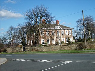
Austhorpe Hall is a house built in 1694 at Austhorpe, Leeds, West Yorkshire, England. It is a grade II* listed building.
Guiseley and Rawdon is a ward in the metropolitan borough and Rawdon is a civil parish in the City of Leeds, West Yorkshire, England. This list also contains the listed buildings in Otley and Yeadon ward. The wards and parish contain 99 listed buildings that are recorded in the National Heritage List for England. Of these, one is listed at Grade I, the highest of the three grades, three are at Grade II*, the middle grade, and the others are at Grade II, the lowest grade. The wards and parish contain the towns of Guiseley and Yeadon, the villages of Rawdon and Hawksworth, and the surrounding area. Most of the listed buildings are houses, cottages and associated structures, farmhouses and farm buildings. The other listed buildings include churches and items in churchyards, a village cross, a school, a former hospital, a railway bridge, a railway tunnel portal and retaining walls, a former tram shed, a town hall, and a telephone kiosk.
Royds is a ward in the metropolitan borough of the City of Bradford, West Yorkshire, England. It contains 30 listed buildings that are recorded in the National Heritage List for England. Of these, two are listed at Grade II*, the middle of the three grades, and the others are at Grade II, the lowest grade. The ward is to the south of the centre of Bradford, and includes the area of Buttershaw, and parts of Horton Bank and Low Moor. The oldest and most important building in the ward is Royds Hall, which is listed, together with a number of associated structures. The other listed buildings consist of houses, cottages and associated structures, farmhouses and farm buildings, public houses, buildings remaining from a former textile mill, a memorial and a school.
Tong is a ward in the metropolitan borough of the City of Bradford, West Yorkshire, England. It contains 48 listed buildings that are recorded in the National Heritage List for England. Of these, two are listed at Grade I, the highest of the three grades, five are at Grade II*, the middle grade, and the others are at Grade II, the lowest grade. The ward is southeast of the centre of Bradford and contains the district of Bierley, which is effectively a suburb of the city, the outlying villages of Tong and Holme, and surrounding areas. The village of Tong contains the two Grade I listed buildings, a large hall, and a church, both with associated listed buildings. Most of the other listed buildings are houses and cottages, farmhouses and farm buildings. The rest include a set of stocks, another church, public houses, a former school, a former cinema, a pinfold, pump, troughs and a smithy, and a war memorial.
Adel and Wharfedale is a ward in the metropolitan borough of the City of Leeds, West Yorkshire, England. It contains 40 listed buildings that are recorded in the National Heritage List for England. Of these, one is listed at Grade I, the highest of the three grades, and the others are at Grade II, the lowest grade. The ward is to the north of the centre of Leeds, and contains the areas of Adel and Cookridge, and countryside to the north. The ward contains St John's Church, which is listed at Grade I, and associated buildings and monuments in the churchyard are listed. Also in the ward is Lawnswood Cemetery, which contains listed buildings and memorials, including a war memorial. In the ward is Cookridge Hall, which is listed together with associated structures. The other listed buildings include houses, farmhouses and farm buildings, two milestones, a public house, and a former reform school.
Alwoodley is a civil parish and a ward in the metropolitan borough of the City of Leeds, West Yorkshire, England. The parish and ward contain 16 listed buildings that are recorded in the National Heritage List for England. All the listed buildings are designated at Grade II, the lowest of the three grades, which is applied to "buildings of national importance and special interest". The area is to the north of the centre of Leeds, and contains the districts of Alwoodley and Moor Allerton. Most of the southern part is residential, and the northern part is rural. The majority of the listed buildings are houses, cottages and associated structures, farmhouses and farm buildings, and some farm buildings have been converted for residential use. There is also a mill converted into a dwelling. The other listed buildings include a road bridge, an aqueduct, a well or reservoir, a church and its lych gate, and a war memorial.
Ardsley and Robin Hood is a ward in the metropolitan borough of the City of Leeds, West Yorkshire, England. It contains 16 listed buildings that are recorded in the National Heritage List for England. Of these, three are listed at Grade II*, the middle of the three grades, and the others are at Grade II, the lowest grade. The ward contains the settlements of East Ardsley, Lofthouse, Robin Hood, Thorpe on the Hill, and West Ardsley, and the surrounding area. Most of the listed buildings are houses and cottages, farm houses and farm buildings, and the others are a church, memorials in the churchyard, and a former textile mill.
Arthington is a civil parish in the metropolitan borough of the City of Leeds, West Yorkshire, England. It contains 17 listed buildings that are recorded in the National Heritage List for England. Of these, one is listed at Grade II*, the middle of the three grades, and the others are at Grade II, the lowest grade. The parish contains the village of Arthington and is otherwise rural. Most of the listed buildings are houses, cottages and associated structures, farmhouses and farm buildings. The other listed buildings consist of a railway viaduct, a church, and a former wagon house.
Barwick in Elmet and Scholes is a civil parish in the metropolitan borough of the City of Leeds, West Yorkshire, England. It contains 23 listed buildings that are recorded in the National Heritage List for England. Of these, three are listed at Grade I, the highest of the three grades, four are at Grade II*, the middle grade, and the others are at Grade II, the lowest grade. The parish contains the villages of Barwick-in-Elmet, Potterton and Scholes, and the surrounding countryside. Part of Bramham Park is in the parish, and in the grounds are listed buildings. The largest house in the parish is Potterton Hall, which is listed together with associated structures. The other listed buildings include a medieval cross base surmounted by a war memorial, a church and its former rectory, other houses, farmhouses and farm buildings, a road bridge, and a milestone.
Beeston and Holbeck is a ward in the metropolitan borough of the City of Leeds, West Yorkshire, England. It contains 24 listed buildings that are recorded in the National Heritage List for England. Of these, two are listed at Grade II*, the middle of the three grades, and the others are at Grade II, the lowest grade. The ward is to the south of the centre of Leeds, it contains the areas of Beeston and Holbeck, and is largely residential. Most of the listed buildings are houses and associated structures. In the ward is Holbeck Cemetery, which contains listed buildings including a memorial. The other listed buildings include a farm building, churches and associated structures, churches later used for other purposes, former schools and associated structures, a railway viaduct, a railway underbridge, and a public house.
City and Hunslet is a ward in the metropolitan borough of the City of Leeds, West Yorkshire, England. It contains over 400 listed buildings that are recorded in the National Heritage List for England. Of these, eight are listed at Grade I, the highest of the three grades, 30 at Grade II*, the middle grade, and the others are at Grade II, the lowest grade.
Farnley and Wortley is a ward in the metropolitan borough of the City of Leeds, West Yorkshire, England. It contains 45 listed buildings that are recorded in the National Heritage List for England. All the listed buildings are designated at Grade II, the lowest of the three grades, which is applied to "buildings of national importance and special interest". The ward includes the area of Wortley a suburb to the west of the city centre of Leeds, and the area of Farnley. The latter is further to the west, and contains the former village of Farnley, the later village of New Farnley to the south, further to the south the settlement of Upper Moor Side, and the surrounding countryside. Most of the listed buildings are houses, cottages and associated structures, farmhouses and farm buildings. The other listed buildings include churches, the cupola of a previous church, surviving buildings of a former textile mill, a public house, schools, and a war memorial.
Garforth and Swillington is a ward and Swillington is a civil parish in the metropolitan borough of the City of Leeds, West Yorkshire, England. The ward and parish contain 22 listed buildings that are recorded in the National Heritage List for England. Of these, two are listed at Grade II*, the middle of the three grades, and the others are at Grade II, the lowest grade. The area covered by the list includes the town of Garforth, the village of Swillington, and the surrounding countryside. The listed buildings include houses and associated structures, farmhouses, churches, a sundial in a churchyard, road and railway bridges, and mileposts.
Aberford and Lotherton cum Aberford are adjacent civil parishes in the metropolitan borough of the City of Leeds, West Yorkshire, England. The parishes contain 25 listed buildings that are recorded in the National Heritage List for England. Of these, one is listed at Grade II*, the middle of the three grades, and the others are at Grade II, the lowest grade. The parishes contain the village of Aberford and the surrounding countryside, including the area around Lotherton Hall. Most of the listed buildings are houses and cottages, and the others include churches, a market cross, a former water mill and a former windmill, a bridge, farm buildings, a hotel and a former stable block, a war memorial, and three milestones.
Parlington is a civil parish in the metropolitan borough of the City of Leeds, West Yorkshire, England. The parish contains 18 listed buildings that are recorded in the National Heritage List for England. Of these, two are listed at Grade II*, the middle of the three grades, and the others are at Grade II, the lowest grade. The parish was centred on the country house of Parlington Hall, but this was largely demolished in 1952. Most of the listed buildings are in the remaining estate, and include a triumphal arch, a bridge, a tunnel, the home farm, a garden house and associated garden walls, an icehouse, a group of stallion pens, a deer shelter, and lodges at the entrances to the grounds. The other listed buildings are a group of almshouses and associated structures, a farmhouse, and a milepost.
Roundhay is a ward in the metropolitan borough of the City of Leeds, West Yorkshire, England. It contains 50 listed buildings that are recorded in the National Heritage List for England. Of these, one is listed at Grade II*, the middle of the three grades, and the others are at Grade II, the lowest grade. The ward is to the northeast of the centre of Leeds, and includes the suburbs of Roundhay, Gledhow, and Oakwood. The ward is mainly residential, and most of the listed buildings are houses, cottages and associated structures, farmhouses and farm buildings. The other listed buildings include an open-air bath, a bridge, schools, a hotel, churches and a gravestone in a churchyard, a folly, a row of almshouses, a hospital, a drinking fountain, a shop, and a clock tower.
Temple Newsam is a ward in the metropolitan borough of the City of Leeds, West Yorkshire, England. It contains 51 listed buildings that are recorded in the National Heritage List for England. Of these, two are listed at Grade I, the highest of the three grades, three are at Grade II*, the middle grade, and the others are at Grade II, the lowest grade. The ward is to the east of the centre of Leeds, it is largely residential, and contains the suburbs of Colton, Halton, Halton Moor and Whitkirk. The most important building in the ward is Temple Newsam House, which is listed, together with associated structures and buildings in the surrounding park. Most of the other listed buildings are houses, cottages and associated structures, farmhouses and farm buildings. The rest include churches and associated structures, a former windmill and mill buildings, two railway bridges, and a school.
Thorp Arch is a civil parish in the metropolitan borough of the City of Leeds, West Yorkshire, England. The parish contains 27 listed buildings that are recorded in the National Heritage List for England. Of these, one is listed at Grade II*, the middle of the three grades, and the others are at Grade II, the lowest grade. Most of the listed buildings are houses, cottages and associated structures. The other listed buildings include a church and items in the churchyard, a farmhouse and farm buildings, former mill buildings, a road bridge and railway bridges, a railway station and an engine shed, and a former smithy.
Thorner and Wothersome are civil parishes in the metropolitan borough of the City of Leeds, West Yorkshire, England. The parishes contain 34 listed buildings that are recorded in the National Heritage List for England. All the listed buildings are designated at Grade II, the lowest of the three grades, which is applied to "buildings of national importance and special interest". The parishes contain the village of Thorner, the area of Wothersome, and the surrounding countryside. Most of the listed buildings are houses and associated structures, the majority along Main Street of Thorner. The others include a cross base and shaft, a church and a grave slab in the churchyard, a former church and attached Sunday school, a farmhouse, farm buildings, a road bridge, and a milestone.


