Tockholes is a civil parish in Blackburn with Darwen, Lancashire, England. It contains 26 buildings that are recorded in the National Heritage List for England as designated listed buildings. Of these, three are listed at Grade II*, the middle grade, and the others are at Grade II, the lowest grade. Apart from the village of Tockholes, the parish is rural. The great majority of the listed buildings are farmhouses and associated farm buildings. Three of the other listed buildings are associated with the parish church, namely a sundial, a former school, and a lychgate, and the last is a structure over a well or spring in the grounds of the now-demolished Hollinshead Hall.
Hoghton is a civil parish in the Borough of Chorley, Lancashire, England. It contains 16 buildings that are recorded in the National Heritage List for England as designated listed buildings. Of these, two are listed at Grade I, the highest of the three grades, and the others are at Grade II, the lowest grade. The major building in the parish is Hoghton Tower; this and associated structures are listed. Otherwise the parish in mainly rural, and a number of farmhouses and farm buildings are listed. The other listed buildings consist of two churches, a former school, a war memorial, and a railway viaduct.
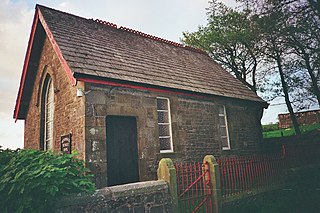
Weeton-with-Preese is a civil parish in the Borough of Fylde, Lancashire, England. It contains three buildings that are recorded in the National Heritage List for England as designated listed buildings, all of which are listed at Grade II. This grade is the lowest of the three gradings given to listed buildings and is applied to "buildings of national importance and special interest". Apart from the village of Weeton, the parish is rural. The listed buildings consist of a former farmhouse, a former farm building, and a church.
Cockerham is a civil parish in Lancaster, Lancashire, England. It contains 19 listed buildings that are recorded in the National Heritage List for England. Of these, two are listed at Grade II*, the middle grade, and the others are at Grade II. Apart from the village of Cockerham, the parish is rural, and most of the listed buildings are houses, cottages, farmhouses and farm buildings. The other listed buildings include a church, the base of a sundial, boundary stones, and a bridge.
Gressingham is a civil parish in Lancaster, Lancashire, England. It contains 14 listed buildings that are recorded in the National Heritage List for England. Of these, one is listed at Grade I, the highest of the three grades, two are at Grade II*, the middle grade, and the others are at Grade II, the lowest grade. Apart from the village of Gressingham and the settlement of Eskrigge, the parish is rural. Almost all the listed buildings are houses and associated structures, farmhouses, and farm buildings. Also listed are a church and a bridge crossing the River Lune on the boundary of the parish.
Leck is a civil parish in Lancaster, Lancashire, England. It contains 21 listed buildings that are recorded in the National Heritage List for England. All of the listed buildings are designated at Grade II, the lowest of the three grades, which is applied to "buildings of national importance and special interest". Other than the small settlement of Leck, the parish is rural. The most substantial building in the parish is Leck Hall; this and associated buildings are listed. Most of the other listed buildings are houses, farmhouses and associated structures. Also listed are a church and stones of various types.
Melling-with-Wrayton is a civil parish in Lancaster, Lancashire, England. It contains 22 listed buildings that are recorded in the National Heritage List for England. Of these, one is listed at Grade I, the highest of the three grades, one is at Grade II*, the middle grade, and the others are at Grade II, the lowest grade. The parish contains the village of Melling and the hamlet of Wrayton, and is otherwise rural. Most of the listed buildings are houses, farmhouses and associated structures. The others include a church and associated structures, and two milestones.
Middleton, Lancashire is a civil parish in Lancaster, Lancashire, England. It contains nine listed buildings that are recorded in the National Heritage List for England. All of the listed buildings are designated at Grade II, the lowest of the three grades, which is applied to "buildings of national importance and special interest". The parish contains the village of Middleton, and at one time the Middleton Tower Holiday Camp, which converted some of the existing buildings for its purposes. Otherwise the parish is mainly rural. Most of the listed buildings are, or originated as, houses, farmhouses and associated structures. In addition a folly and a public house are listed.
Over Wyresdale is a civil parish in Lancaster, Lancashire, England. It contains 53 buildings that are recorded in the National Heritage List for England as designated listed buildings. Of these, one is at Grade II*, the middle grade, and the others are at Grade II, the lowest grade.
Quernmore is a civil parish in Lancaster, Lancashire, England. It contains 28 listed buildings that are recorded in the National Heritage List for England. Of these, one is listed at Grade I, the highest of the three grades, one is at Grade II*, the middle grade, and the others are at Grade II, the lowest grade. Apart from the small village of Quernmore, the parish is rural. Most of the listed buildings are houses, farmhouses, and associated structures. The most important house in the parish is Quernmore Park; this and associated buildings are listed. The other listed buildings include a church, a former school, an aqueduct, a former corn mill, and a former railway bridge.
Silverdale is a civil parish in Lancaster, Lancashire, England. It contains 20 buildings that are recorded in the National Heritage List for England as designated listed buildings. Of these, two are at Grade II*, the middle grade, and the others are at Grade II, the lowest grade. Most of the listed buildings in the parish are houses and associated structures, or farmhouses and farm buildings. The other listed buildings include a former chimney, a church, a public house, and a limekiln.
Tatham is a civil parish in Lancaster, Lancashire, England. It contains 47 buildings that are recorded in the National Heritage List for England as designated listed buildings. Of these, two are at Grade II*, the middle grade, and the others are at Grade II, the lowest grade. Apart from the small settlement of Lowgill, the parish is rural, containing widespread farms. Most of the listed buildings are farmhouses, farm buildings and houses. The other listed buildings include two churches, two boundary stones, a derelict colliery engine house, a public house, and a telephone kiosk.
Whittington is a civil parish in Lancaster, Lancashire, England. It contains 39 buildings that are recorded in the National Heritage List for England as designated listed buildings. Of these, three are at Grade II*, the middle grade, and the others are at Grade II, the lowest grade. The parish contains the villages of Whittington, Docker and Newton, and is otherwise rural. Most of the listed buildings are country houses with associated structures, smaller houses, and farm buildings. The other listed buildings include a church with a sundial in the churchyard, buildings on a model farm, three milestones, a boundary stone, and a former school.
Wray-with-Botton is a civil parish in Lancaster, Lancashire, England. It contains 44 listed buildings that are recorded in the National Heritage List for England. All of the listed buildings are designated at Grade II, the lowest of the three grades, which is applied to "buildings of national importance and special interest". The parish contains the village of Wray, and is otherwise rural containing scattered farms. Apart from a bridge, all the listed buildings are houses, farmhouses, farm buildings, and structures associated with them.
Haighton is a civil parish in the City of Preston, Lancashire, England. It contains seven listed buildings that are recorded in the National Heritage List for England. All of the listed buildings are designated at Grade II, the lowest of the three grades, which is applied to "buildings of national importance and special interest". The parish is entirely rural, and all the listed buildings are houses, farmhouses, or farm buildings
Aighton, Bailey and Chaigley is a civil parish in Ribble Valley, Lancashire, England. It contains 55 listed buildings that are recorded in the National Heritage List for England. Of these, three are listed at Grade I, the highest of the three grades, five are at Grade II*, the middle grade, and the others are at Grade II, the lowest grade. The most important building in the parish is Stonyhurst College; many of the buildings comprising the college and associated with it are listed. The parish contains the village of Hurst Green, which also contains listed buildings, including houses, public houses, and almshouses. Outside these areas the listed buildings include other houses and associated structures, farmhouses and farm buildings, crosses, the ruins of a chapel, bridges, a mausoleum, a church, and a vicarage.
Downham is a civil parish in Ribble Valley, Lancashire, England. It contains 43 listed buildings that are recorded in the National Heritage List for England. Of these, three are at Grade II*, the middle grade, and the others are at Grade II, the lowest grade. The parish contains the village of Downham and surrounding countryside. Most of the listed buildings are in the village, and include Downham Hall and associated structures, houses and cottages, a church, a public house, a school, milestones, a bridge, and a set of stocks. Outside the village the listed buildings are farmhouses and farm buildings.
Great Mitton is a civil parish in Ribble Valley, Lancashire, England. It contains 17 listed buildings that are recorded in the National Heritage List for England. Of these, one is listed at Grade I, the highest of the three grades, one is at Grade II*, the middle grade, and the others are at Grade II, the lowest grade. The parish contains the village of Great Mitton and is otherwise completely rural. It is bounded by the Rivers Hodder and Ribble, and bridges crossing them are listed. The other listed buildings include houses, farmhouses, a barn, a church with associated strictures, public houses, a cross base, and a milestone.
Simonstone is a civil parish in Ribble Valley, Lancashire, England. It contains 22 listed buildings that are recorded in the National Heritage List for England. All of the listed buildings are designated at Grade II, the lowest of the three grades, which is applied to "buildings of national importance and special interest". The parish contains the village of Simonstone and surrounding countryside. The listed buildings are almost all houses and associated structures, or farmhouses and farm buildings, the others being a milestone and a former toll house.
Bleasdale is a civil parish in the Wyre district of Lancashire, England. It contains six listed buildings that are recorded in the National Heritage List for England. All the listed buildings are designated at Grade II, the lowest of the three grades, which is applied to "buildings of national importance and special interest". The parish is entirely rural, and apart from a church, all the listed buildings are farmhouses.