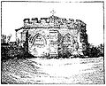
Cockersand Abbey

Last updated

Cockersand Abbey
Cockersand Abbey 1.jpg
Location Thurnham, Lancashire
Coordinates 53°58′37″N2°52′30″W / 53.977°N 2.875°W / 53.977; -2.875
Official nameCockersand Premonstratensian Abbey
Designated13 January 1915 [1]
Reference no. 1018919
Listed Building – Grade I
Official name The Chapter House, Cockersand Abbey
Designated2 May 1968 [2]
Reference no. 1362525
Location map United Kingdom City of Lancaster.svg
Red pog.svg
Location in the City of Lancaster district
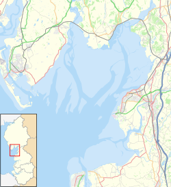
Location map United Kingdom Morecambe Bay.svg
Red pog.svg
Location on Morecambe Bay
Lancashire UK location map.svg
Red pog.svg
Location in Lancashire

Cockersand Abbey is a former abbey and former civil parish near Cockerham in the City of Lancaster district of Lancashire, England. It is situated near the mouth of the River Cocker.

Contents

History

It was founded before 1184 as the Hospital of St Mary on the marsh belonging to Leicester Abbey. It was refounded by the Cambro-Norman magnate, Theobald Walter, 1st Baron Butler, as a Premonstratensian priory in 1190. It was subsequently elevated to an abbey in 1192. It also continued as a hospital. [3] The Abbey was originally located in marsh land which was later drained, becoming known as St. Mary's of the Marsh. [4]

The abbey was the third richest in Lancashire when it was dissolved in 1539 and acquired by a John Kechyn in 1544. [5] The site is now adjacent to a farm house and the only significant relic is the still intact, vaulted Cockersand Abbey chapter house, which was built in 1230 and used as a family mausoleum by the Daltons of Thurnham Hall during the 18th and 19th centuries. [6] The land was acquired by the Daltons shortly after 1556, when Robert Dalton married Ann Kitchen [7] There are some scrappy remains of the church adjacent. A tradition that the medieval choir stalls in the nearby Lancaster Priory originated from here has been discredited.[ citation needed ]

The chapter house is a Grade I listed building and scheduled ancient monument. In 2007 English Heritage made an £80,000 grant to the owner to help preserve the building. [6] The chapter house is open to the public on special occasions such as Heritage Open Days.

Roman statuettes

Two Roman statuettes were discovered on Cockersand Moss near the abbey site in 1718, possibly indicating the presence of a Romano-British shrine nearby. One statuette of Mars, which was art of Lord Arundel's collection that William Stukeley exhibited in 1719 to the Society of Antiquaries was an inscription which has been recorded as DEO MARTI NODONTI AVRJELIVS ..... CINVS SIG (Deo Marti Nodonti Aurelius ..... cinus sig(illum)). The second, smaller and inferior quality, statuette was reported as containing the inscription LVCIANVSJD.M.Nl COL LIC APRILI VIATOjRIS VS (D(eo)M(arti) N(odonti) LucianusI collic(io) Aprili Viato ris v(otum) s(olvit)). [8] [9] [10] [11]

List of dignitaries

Civil parish

The civil parish of Cockersand Abbey was created as a local government unit in 1858, and was part of Lancaster Rural District. It was abolished and incorporated into Thurnham civil parish in 1935. [12] The population was recorded as 26 in 1871, 53 in 1901, and 25 in 1931 [13] The parish included the area around the abbey and extended north and south along the coast. [14]

See also

Related Research Articles

<span class="mw-page-title-main">Nodens</span> Celtic deity

*Nodens or *Nodons is a Celtic healing god worshipped in Ancient Britain. Although no physical depiction of him has survived, votive plaques found in a shrine at Lydney Park (Gloucestershire) indicate his connection with dogs, a beast associated with healing symbolism in antiquity. The deity is known in only one other location, in Cockersand Moss (Lancashire). He was equated on most inscriptions with the Roman god Mars and associated in a curse with Silvanus. His name is cognate with that of later Celtic mythological figures, such as the Irish Nuada and the Welsh Nudd.

<span class="mw-page-title-main">Blackburn Hundred</span> Former sub-division of Lancashire, UK

Blackburn Hundred is a historic sub-division of the county of Lancashire, in northern England. Its chief town was Blackburn, in the southwest of the hundred. It covered an area similar to modern East Lancashire, including the current districts of Ribble Valley, Pendle, Burnley, Rossendale, Hyndburn, Blackburn with Darwen, and South Ribble.

<span class="mw-page-title-main">Clitheroe Castle</span> Medieval castle in Lancashire, England

Clitheroe Castle is a ruined early medieval castle in Clitheroe in Lancashire, England. It was the caput of the Honour of Clitheroe, a vast estate stretching along the western side of the Pennines.

<span class="mw-page-title-main">Caton-with-Littledale</span> Human settlement in England

The civil parish of Caton-with-Littledale is situated in Lancashire, England, near the River Lune. The parish lies within the Forest of Bowland Area of Outstanding Natural Beauty and contains the villages of Caton, Brookhouse, Caton Green, Littledale and Townend.

<span class="mw-page-title-main">Singleton, Lancashire</span> Human settlement in England

Singleton is a village and civil parish in Lancashire, England. It is situated on the coastal plain called the Fylde. It is located south-east of Poulton-le-Fylde, and at the 2001 census had a population of 877, increasing to 889 at the 2011 Census. The parish is sometimes referred to as two parts – Great Singleton is the larger part containing the village, and Little Singleton is a small area north of the village bordering the River Wyre.

<span class="mw-page-title-main">Aldcliffe</span> Human settlement in England

Aldcliffe is a hamlet, and former township and civil parish, in the civil parish of Aldcliffe-with-Stodday, south-west of Lancaster in Lancashire, England. The hamlet is located on the east bank of the River Lune, and is one and a half miles south west of the Lancaster city centre.

<span class="mw-page-title-main">Pendleton, Lancashire</span> Human settlement in England

Pendleton is a small village and civil parish in Ribble Valley, within the county of Lancashire, England. It is close to the towns of Whalley and Clitheroe. The parish lies on the north west side of Pendle Hill below the Nick o' Pendle. The village is just off the A59, Liverpool to York main road, since the construction of the Clitheroe By-Pass. Older roads through the parish include one from Clitheroe to Whalley which passes through the Standen area and another to Burnley which passes Pendleton Hall.

<span class="mw-page-title-main">Lancaster Priory</span> Church in Lancashire, England

Lancaster Priory, formally the Priory Church of St Mary, is the Church of England parish church of the city of Lancaster, Lancashire, England. It is located near Lancaster Castle and since 1953 has been designated a Grade I listed building. It is in the deanery of Lancaster, the archdeaconry of Lancaster and the Diocese of Blackburn. Its benefice is combined with that of St John and St Anne.

This is a list of Grade I listed buildings in Lancashire, England.

<span class="mw-page-title-main">Honour of Clitheroe</span>

The Honour of Clitheroe is an ancient grouping of manors and royal forests centred on Clitheroe Castle in Lancashire, England; an honour traditionally being the grant of a large landholding complex, not all of whose parts are contiguous. In the case of Clitheroe, this complex was loosely clustered around the ancient wapentake of Blackburnshire.

Cockerham Priory was a priory served by Austin Canons in Cockerham, Lancashire, England. St Michael's Church was granted to Leicester Abbey c. 1153–54, with some land. The priory was founded in 1207 or 1208 as a cell of the Abbey of St Mary de Pratis in Leicester.

<span class="mw-page-title-main">Easington, Lancashire</span> Human settlement in England

Easington is a civil parish within the Ribble Valley district of Lancashire, England, with a population in 2001 of 52. The Census 2011 population details have been grouped with the parish of Slaidburn. Before 1974, it formed part of Bowland Rural District in the West Riding of Yorkshire. It covers just over 9000 acres.

<span class="mw-page-title-main">Gisburn Forest</span> Civil parish in Ribble Valley in Lancashire, England

Gisburn Forest is a civil parish in the Ribble Valley, in Lancashire, England. Mainly lying within the Forest of Bowland Area of Outstanding Natural Beauty, the parish includes the larger part of the village of Tosside and the hamlet of Grunsagill to the south. Historically, the parish lay within the West Riding of Yorkshire. It had a population of 151 at the 2011 Census.

<span class="mw-page-title-main">Ashton Hall</span> Mansion in Lancashire, England

Ashton Hall is a largely rebuilt 14th-century mansion in the civil parish of Thurnham, Lancashire, England. It is 3 miles (4.8 km) south of the city of Lancaster and is on the east bank of the River Lune. It is recorded in the National Heritage List for England as a Grade I listed building, and is now owned by Lancaster Golf Club.

Craven in the Domesday Book Historic region in Yorkshire

The extent of the medieval district of Craven, in the north of England is a matter of debate. The name Craven is either pre-Celtic Britain, Britonnic or Romano-British in origin. However, its usage continued following the ascendancy of the Anglo-Saxons and the Normans – as was demonstrated by its many appearances in the Domesday Book of 1086. Places described as being In Craven in the Domesday Book fell later within the modern county of North Yorkshire, as well as neighbouring areas of West Yorkshire, Lancashire and Cumbria. Usage of Craven in the Domesday Book is, therefore, circumstantial evidence of an extinct, British or Anglo-Saxon kingdom or subnational entity.

Thurnham is a civil parish in Lancaster, Lancashire, England. It contains 37 listed buildings that are recorded in the National Heritage List for England. Of these, three are listed at Grade I, the highest of the three grades, three are at Grade II*, the middle grade, and the others are at Grade II, the lowest grade.

<span class="mw-page-title-main">Scheduled monuments in Lancashire</span>

This is a list of scheduled monuments in the English county of Lancashire.

Lancaster Rural District was a rural district in the county of Lancashire, England. It was created in 1894 and abolished in 1974 under the Local Government Act 1972.

<span class="mw-page-title-main">Cockersand Abbey chapter house</span> Listed building in Lancashire

Cockersand Abbey chapter house is a mausoleum in the English village of Thurnham, Lancashire. A Grade I listed building and formerly part of Cockersand Abbey, it dates to 1230. It was used as a family mausoleum by the Daltons of Thurnham Hall during the 18th and 19th centuries. The land was acquired by the Daltons shortly after 1556, when Robert Dalton married Ann Kitchen.

References

Footnotes

  1. Historic England. "Cockersand Premonstratensian Abbey (1018919)". National Heritage List for England . Retrieved 28 January 2012.
  2. Historic England. "The Chapter House, Cockersand Abbey (1362525)". National Heritage List for England . Retrieved 28 January 2012.
  3. 1 2 Farrer & Brownbill (1908), pp. 154-9
  4. Self, John (2008). The Land of the Lune. Drakkar Press Limited. p. 209.
  5. Self, John (2008). The Land of the Lune. Drakkar Press Limited.
  6. 1 2 "Ancient abbey is saved by grant". BBC News . 21 June 2007. Retrieved 21 November 2008.
  7. The History Of Thurnham Hall https://thurnhamhall.com/history/
  8. Wright, R. (1957). Roman Britain in 1956: I. Sites Explored: II. Inscriptions. The Journal of Roman Studies, 47(1/2), 198-234. doi:10.2307/298586
  9. Cockersand Moss Archived 14 July 2007 at the Wayback Machine , Roman Britain.org.
  10. https://romaninscriptionsofbritain.org/inscriptions/616 Roman Inscriptions of Britain RIB 616. Dedication to Mars Nodons
  11. https://romaninscriptionsofbritain.org/inscriptions/617 Roman Inscriptions of Britain RIB 617. Dedication to Mars Nodons
  12. "Cockersand Abbey CP: Relationships and changes". www.visionofbritain.org.uk. Retrieved 15 May 2020.
  13. "Cockersand Abbey CP: Total Population". www.visionofbritain.org.uk. Vision of Britain. Retrieved 15 May 2020.
  14. "Cockersand Abbey CP: Boundary Map". www.visionofbritain.org.uk. Vision of Britain. Retrieved 15 May 2020.

Sources