The Sierra Nevada is a mountain range in the Western United States, between the Central Valley of California and the Great Basin. The vast majority of the range lies in the state of California, although the Carson Range spur lies primarily in Nevada. The Sierra Nevada is part of the American Cordillera, an almost continuous chain of mountain ranges that forms the western "backbone" of the Americas.

Plumas County is a county in the Sierra Nevada of California, United States. As of the 2020 census, the population was 19,790. The county seat is Quincy, and the only incorporated city is Portola. The largest community in the county is East Quincy. The county was named for the Spanish Río de las Plumas, which flows through it.

The Feather River is the principal tributary of the Sacramento River, in the Sacramento Valley of Northern California. The river's main stem is about 73 miles (117 km) long. Its length to its most distant headwater tributary is just over 210 miles (340 km). The main stem Feather River begins in Lake Oroville, where its four long tributary forks join—the South Fork, Middle Fork, North Fork, and West Branch Feather Rivers. These and other tributaries drain part of the northern Sierra Nevada, and the extreme southern Cascades, as well as a small portion of the Sacramento Valley. The total drainage basin is about 6,200 square miles (16,000 km2), with approximately 3,604 square miles (9,330 km2) above Lake Oroville.

Lake Oroville is a reservoir formed by the Oroville Dam impounding the Feather River, located in Butte County, northern California. The lake is situated 5 miles (8 km) northeast of the city of Oroville, within the Lake Oroville State Recreation Area, in the western foothills of the Sierra Nevada. Known as the second-largest reservoir in California, Lake Oroville is treated as a keystone facility within the California State Water Project by storing water, providing flood control, recreation, freshwater releases assist in controlling the salinity intrusion into the Sacramento-San Joaquin Delta and protecting fish and wildlife.
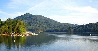
Bass Lake is located in the Sierra National Forest, of Madera County, California, approximately 14 mi (23 km) south of the entrance to Yosemite National Park. The lake is approximately four miles long and one-half mile wide.
Courtright Reservoir is a reservoir in Fresno County, California. The reservoir is at an elevation of 8,170 feet in the Sierra National Forest, in the Sierra Nevada Mountain Range, bordering the John Muir Wilderness and the Dinkey Lakes Wilderness.
Lake Almanor is a large reservoir in northwestern Plumas County, northeastern California, United States. The reservoir has a capacity of 1,308,000 acre-feet (1.613×10⁹ m3) and a maximum depth of about 90 feet (27 meters). It is formed by Canyon Dam on the North Fork of the Feather River, as well as Benner and Last Chance Creeks, Hamilton Branch, and various natural springs.
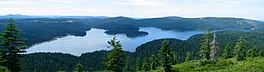
Lake Davis is an artificial lake in Plumas County, California near the Sierra Nevada community of Portola. Its waters are impounded by Grizzly Valley Dam, which was completed in 1966 as part of the California State Water Project. The lake is named for Lester T. Davis (1906-1952).

Silverwood Lake is a large reservoir in San Bernardino County, California, United States, located on the West Fork Mojave River, a tributary of the Mojave River in the San Bernardino Mountains. It was created in 1971 as part of the State Water Project by the construction of the Cedar Springs Dam as a forebay on the 444 mi (715 km) long California Aqueduct, and has a capacity of 73,000 acre⋅ft (90,000,000 m3).

Frenchman Lake is a reservoir located in souutheastern Plumas County, California. It was created by the damming of Little Last Chance Creek in 1961, as part of the California State Water Project. It was named after its tributary Frenchman Creek, which in turn was named after Claude Francois Seltier, a French immigrant who settled in the area in 1858.

Lake Pillsbury is a lake in the Mendocino National Forest of Lake County, California, created from the Eel River and Hull Mountain watershed by Scott Dam. Elevation is 1,818 ft (554 m) with 65 mi (105 km) of shoreline and covering 2,003 acres (811 ha). Activities in the Lake Pillsbury Recreation Area include powerboating, fishing, swimming, sailing, picnicking, hiking and hang gliding. There are two main access roads to the lake. At the north end of the lake is a small gravel airstrip. About 400 vacation cabins including National Forest Recreational Residences ring the lake.
The Bucks Lake Wilderness is a 23,958-acre (97.0 km2) wilderness area located in the Plumas National Forest section of the Sierra Nevada, in northeastern California, United States.
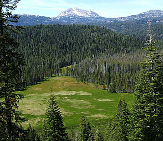
Red Clover Creek is a west-northwestward-flowing stream originating on Horton Ridge east of the Sierra Nevada crest in Plumas County, California, United States. It courses 27 miles (43 km) through Dotta Canyon and Red Clover Valley to its confluence with Last Chance Creek in Genesee Valley, just above its confluence with Indian Creek, which flows into the East Branch North Fork Feather River. The Red Clover Valley sits at an elevation of about 5,400 feet (1,600 m) and is located on the east side of the Sierra Nevada crest, approximately 60 miles (97 km) north of Truckee and 30 miles (48 km) east of Quincy.
The Feather Headwaters is the watershed of the Feather River above Lake Oroville, totaling 3,450 sq mi (8,900 km2). Subdivided into 3 watersheds, the North Fork Feather Watershed is 1,090 sq mi (2,800 km2)—including the West Branch drainage of about 282.5 sq mi (732 km2), the East Branch North Fork Feather Watershed is 1,010 sq mi (2,600 km2), and the Middle Fork Feather Watershed is 1,350 sq mi (3,500 km2)—including the South Fork drainage of about 132 sq mi (340 km2). Headwaters drainage is impaired by the Palermo Canal at Oroville Dam, the Hendricks Canal at the West Branch Feather River, and the Miners Ranch Canal at the South Fork's Ponderosa Reservoir. Additionally, the Pacific Gas and Electric Company releases Upper Feather water into the Hyatt Generating-Pumping Plant for hydroelectric generation during daily peak demand.

The Middle Fork American River is one of three forks that form the American River in Northern California. It drains a large watershed in the high Sierra Nevada west of Lake Tahoe and northeast of Sacramento in Placer and El Dorado Counties, between the watersheds of the North Fork American River and South Fork American River. The Middle Fork joins with the North Fork near Auburn and they continue downstream to Folsom Lake as the North Fork, even though the Middle Fork carries a larger volume of water.
Wishon Dam is a dam in Fresno County, California in the Sierra National Forest, in the Sierra Nevada Mountain Range. It impounds the North Fork Kings River to form Wishon Reservoir.
Sly Creek Dam is a dam in Butte County, California.

Antelope Dam or Antelope Valley Dam is a dam in Plumas County, California, part of the California State Water Project.
Strawberry Dam, also known as Main Strawberry Dam, is a dam in Tuolumne County, California.

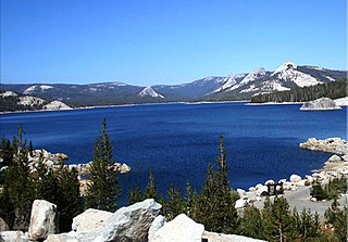
Lake Thomas A Edison is a reservoir in the Sierra National Forest and in Fresno County, California. It is in the Sierra Nevada, and near the Pacific Crest Trail.