Related Research Articles
Buckinghamshire, is a ceremonial county in South East England and one of the home counties. It is bordered by Northamptonshire to the north, Bedfordshire to the north-east, Hertfordshire to the east, Greater London to the south-east, Berkshire to the south, and Oxfordshire to the west. The largest settlement is the city of Milton Keynes, and the county town is Aylesbury.
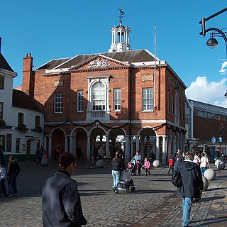
High Wycombe, often referred to as Wycombe, is a market town in Buckinghamshire, England. Lying in the valley of the River Wye surrounded by the Chiltern Hills, it is 29 miles (47 km) west-northwest of Charing Cross in London, 13 miles (21 km) south-southeast of Aylesbury, 23 miles (37 km) southeast of Oxford, 15 miles (24 km) northeast of Reading and 8 miles (13 km) north of Maidenhead.

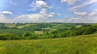
The Chiltern Hills are a chalk escarpment in southern England, northwest of London, covering 660 square miles (1,700 km2) across Oxfordshire, Buckinghamshire, Hertfordshire, and Bedfordshire, stretching 45 miles (72 km) from Goring-on-Thames in the southwest to Hitchin in the northeast. The hills are 12 miles (19 km) at their widest.

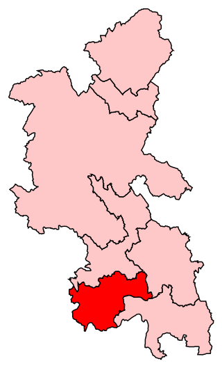
Wycombe District was a local government district in Buckinghamshire in south-central England. Its council was based in the town of High Wycombe. The district was abolished on 31 March 2020 and its area is now administered by the unitary Buckinghamshire Council. It had introduced locality budgets before October 2013.

Dorney is a village and civil parish in the Unitary Authority of Buckinghamshire, England, bordering on the River Thames to the west and south, and bisected by the Jubilee River. In 2011 it had a population of 752. It is 2.3 miles (3.7 km) west of neighbouring Eton, which is a slightly larger parish.

Bourne End is a village mostly in the parish of Wooburn, but partly in that of Little Marlow in Buckinghamshire, England. It is about five miles (8 km) south-east of High Wycombe and three miles (5 km) east of Marlow, near the boundary with Berkshire and close to where the Buckinghamshire River Wye empties into the Thames.

Marlow is a town and civil parish within the Unitary Authority of Buckinghamshire, England. It is located on the River Thames, 4 miles (6 km) south-southwest of High Wycombe, 5 miles (8 km) west-northwest of Maidenhead and 33 miles (53 km) west of central London.
Lane End is a village and civil parish in Buckinghamshire, England. It is just south of the M40 from High Wycombe, about 2 miles (3.2 km) west of Booker. The village is twinned with Saint-Pierre-d'Oléron in France.

Little Marlow is a village and civil parish in Buckinghamshire, England.

Wooburn is a large village in Buckinghamshire, England. It is located off the A4094 road between Wooburn Green and Bourne End in the very south of the county near the River Thames, about two miles south west of Beaconsfield and four miles east of Marlow. Wooburn is one of the two principal settlements within Wooburn, a civil parish in Wycombe district.
Wycombe is a constituency in Buckinghamshire represented in the House of Commons of the UK Parliament since 2010 by Steve Baker, a Conservative.
Beaconsfield is a constituency in Buckinghamshire represented in the House of Commons of the UK Parliament since 2019 by Joy Morrissey of the Conservative Party. She succeeded Independent and former Conservative Dominic Grieve, whom she defeated following his suspension from the party. The constituency was established for the February 1974 general election.

The Marlow branch line is a single track railway line in England, between Maidenhead station in Berkshire and Bourne End and Marlow stations in Buckinghamshire. It is 7 miles 10 chains (11.5 km) in length. Passenger services are operated by Great Western Railway using Class 165 and Class 166 diesel trains. The line connects to the Great Western Main Line at Maidenhead; it uses a section of the former Wycombe Railway line to High Wycombe together with the former Great Marlow Railway.

Wycombe Marsh is an area of High Wycombe, Buckinghamshire, England. It lies on the River Wye and the A40 road, approximately 1.5 miles (2.4 km) south-east of High Wycombe town centre, and approximately 1 mile (1.6 km) north-west of Loudwater. Wycombe Marsh is in the Ryemead ward of High Wycombe, which had a population of 7,188 at the 2011 census.
Well End is a hamlet in the parish of Little Marlow, in Buckinghamshire, England. It is situated on the north-west side of the village of Bourne End. Although it lies in a separate parish, it is geographically contiguous with and subordinate to Bourne End; but unlike most of the hamlets consumed by its larger neighbour, it retains a distinct character, and the use of the name is common and well recognised locally.

Maple Cross is a village in Hertfordshire, England, which up until the Second World War consisted of an inn, a blacksmith's shop and a few cottages. Today there are around 800 postwar council houses. Some of these have been sold into private ownership. The area is close by junction 17 of the M25 motorway, which makes up the western boundary of the village. It lies on the western fringe of Rickmansworth, about 5 miles (8.0 km) west of Watford and 6 miles north of Uxbridge.

Marlow Urban District was a local government authority in the administrative county of Buckinghamshire, England, between 1896 and 1974, covering the town of Marlow.
Forty Green is a small, mainly undeveloped, agricultural area on the west side of Marlow in Buckinghamshire, England. It comprises field parcel numbers 883, 892, 895, 896 and 838 on the civil parish Ordnance Survey map. Its boundaries are not marked with signposts but parcel 892 has an entrance from a residential street carrying the name, Forty Green Drive. At the 2011 Census the population of the area was included in the civil parish of Great Marlow.
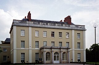
Westhorpe House is a 31,937 square feet (2,967.0 m2) Grade II listed building near Little Marlow which was the home of Maria Nugent and Field marshal Sir George Nugent. The Main House is 20,535 square feet (1,907.8 m2) and the Coach House is 4,027 square feet (374.1 m2).
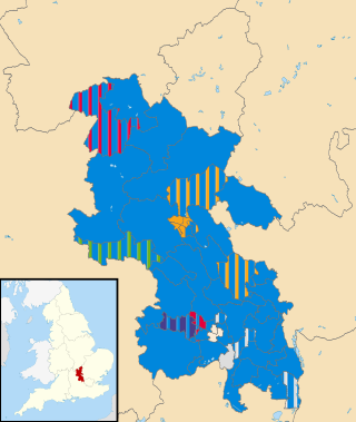
The 2021 Buckinghamshire Council election took place on 6 May 2021, alongside nationwide local elections. The election was originally due to take place in May 2020, but was postponed due to the COVID-19 pandemic.
References
- 1 2 3 "Wycombe District Council purchases Spade Oak Quarry - Little Marlow Parish Council, Little Marlow, Marlow". www.littlemarlowparishcouncil.org.uk. Retrieved 2023-09-14.
- 1 2 "Decision - Little Marlow Lakes Country Park". buckinghamshire.moderngov.co.uk. 2022-10-11. Retrieved 2023-09-14.
- 1 2 3 "Little Marlow Gravel Pits: Supplementary Planning Guidance" (PDF).
- 1 2 "Countryside Act 1968 Section 7".
- ↑ "Meeting of WDC Council on Monday, 9th October, 2017, 6.30 pm". buckinghamshire.moderngov.co.uk. 2017-10-09. Retrieved 2023-09-14.
- ↑ "NEW WYCOMBE DISTRICT LOCAL PLAN, LITTLE MARLOW LAKES COUNTRY PARK AND COMMUNITY INFRASTRUCTURE LEVY RECEIPTS" (PDF).
- ↑ "Speaker profile for Cllr Graham Peart - Buckinghamshire Council Webcasting". buckinghamshire.public-i.tv. Retrieved 2023-09-14.
- ↑ "Wycombe District Local Plan Adopted August" (PDF).
- 1 2 Cabinet - Tuesday 11 October 2022, 10:00am - Buckinghamshire Council Webcasting , retrieved 2023-09-14
- ↑ "Councillor details - Councillor Peter Strachan". buckinghamshire.moderngov.co.uk. 2023-09-15. Retrieved 2023-09-15.
- ↑ "Report for Little Marlow Lakes Country Park" (PDF).
- ↑ "LITTLE MARLOW GRAVEL PIT". Bucksbirdclub.co.uk.
- ↑ "Pinner & District Local Group - The Royal Society for the Protection of Birds". 2.rspb.org.uk.
- ↑ "Westhorpe Park Mobile Home Park, Buckinghamshire | Park Homes". Parkhome.org.uk.
- ↑ "Athletics track". Wycombe.gov.uk.
- ↑ "Marlow AC - Marlow Angling Club". Marlow-angling-club.co.uk.
- ↑ "Marlow Open Water Swim - Westhorpe Lake". Marlowopenwaterswim.co.uk.
- ↑ "Marlow Water Ski CLUB". Marlowwaterski.co.uk.
- 1 2 "Little Marlow Sewage Treatment Works, Buckinghamshire". Gov.uk.
- ↑ "Big problems in Little Marlow". Thebeyonder.co.uk. October 24, 2018.
- ↑ "'I feel very angry' – TV presenter Steve Backshall 'frustrated' as sewage enters the River Thames". Bucks Free Press .
- ↑ "Walkers seen 'wading through' footpath flooded with sewage after machinery fails". Bucks Free Press .
- ↑ Peterson, Karen M. (2022-10-05). "Building the Worlds of 'Andor': How Ferrix Was Built Brick-by-Brick on a Backlot". Variety. Retrieved 2024-03-11.
- ↑ "Star Wars set built for spin-off show in Little Marlow".