Little Mountain, South Carolina

Last updated

Little Mountain, South Carolina
Little-Mountain-RR-tracks-sc.jpg
Railroad tracks and Church Street
SCMap-doton-LittleMountain.PNG
Location of Little Mountain, South Carolina
Coordinates: 34°11′43″N81°24′50″W / 34.19528°N 81.41389°W / 34.19528; -81.41389
Country United States
State South Carolina
County Newberry
Government
  MayorJana W. Jayroe
Area
[1]
  Total1.52 sq mi (3.94 km2)
  Land1.52 sq mi (3.94 km2)
  Water0.00 sq mi (0.00 km2)
Elevation
[2]
614 ft (187 m)
Population
 (2020) [3]
  Total249
  Density163.82/sq mi (63.25/km2)
Time zone UTC-5 (Eastern (EST))
  Summer (DST) UTC-4 (EDT)
ZIP code
29075
Area code(s) 803, 839
FIPS code 45-41965 [4]
GNIS feature ID1231486 [2]
Website www.littlemountainsc.com

Little Mountain is a town in Newberry County, South Carolina, United States. The population was 291 at the 2010 census. The town took its name from nearby Little Mountain. [5]

Contents

History

The mountain is a monadnock, which is an isolated mountain or rock that has resisted the process of erosion and stands alone in an otherwise flat area.

The Little Mountain Historic District was listed on the National Register of Historic Places in 2003. [6]

Early history

The mountain was referred to as Ruff's Mountain until sometime in the 1800s. It was part of Lexington County until 1917 when the current border was established. Property in this area was not recorded in the Newberry County tax records until some time in the 1920s. The Eastern side of the mountain was once owned by Sam Birge, and later Arthur Kohn. It would change hands between the two several times before coming into the possession of the Derrick family in the 1930s. The other side, including what became the town of Little Mountain, was owned by Abraham N. Boland.

The Town

Frederick H. Dominick was appointed as postmaster in May 1852. Abraham Noah Boland was appointed as postmaster of the Little Mountain Post Office in 1888. The town was founded around a railroad station in 1890: [7] Boland's farm became the site of the depot when the C. N. & L Railroad (Columbia, Newberry, & Laurens Railroad Company) began operation. The town was incorporated and Boland became the first mayor of the town. Today, Boland is considered the "Father of Little Mountain."

Partial Solar Eclipse seen from Little Mountain, SC on April 8, 2024 Partial Solar Eclipse April 8, 2024 - Little Mountain, SC.jpg
Partial Solar Eclipse seen from Little Mountain, SC on April 8, 2024

Early residents were farmers of corn, cotton and grain. The town has become a bedroom community for Columbia, the state capital, 30 miles to the southeast. [7]

Education

In 1892, a school was opened in a tenant house and taught by the pastor of Holy Trinity Lutheran Church, Rev. S. L. Nease. Later a one-room school building was built on an acre of land donated by Noah Boland. Increased enrollment brought a two-room building and finally, in 1908 the plans were made to build the present Little Mountain Elementary School. Several additions and modifications have been made to the building since its original construction.

Geography

Little Mountain is located at 34°11′43″N81°24′50″W / 34.19528°N 81.41389°W / 34.19528; -81.41389 (34.195161, -81.413946). [8]

According to the United States Census Bureau, the town has a total area of 1.1 square miles (2.7 km2), all land.

Little Mountain is located on Interstate 26 at Exit 85, which is approximately 2 miles (3 km) from the heart of downtown.

Climate

Climate data for Little Mountain, South Carolina, 1981-2010 normals, extremes 1894-present
MonthJanFebMarAprMayJunJulAugSepOctNovDecYear
Record high °F (°C)84
(29)
82
(28)
92
(33)
97
(36)
103
(39)
107
(42)
108
(42)
107
(42)
106
(41)
103
(39)
91
(33)
81
(27)
108
(42)
Mean daily maximum °F (°C)51.9
(11.1)
56.5
(13.6)
63.8
(17.7)
71.9
(22.2)
79.4
(26.3)
85.8
(29.9)
88.9
(31.6)
87.0
(30.6)
81.4
(27.4)
72.2
(22.3)
63.4
(17.4)
54.3
(12.4)
71.4
(21.9)
Daily mean °F (°C)42.3
(5.7)
46.1
(7.8)
52.8
(11.6)
60.9
(16.1)
68.9
(20.5)
76.0
(24.4)
79.1
(26.2)
77.6
(25.3)
71.7
(22.1)
61.7
(16.5)
53.0
(11.7)
44.6
(7.0)
61.2
(16.2)
Mean daily minimum °F (°C)32.7
(0.4)
35.8
(2.1)
41.9
(5.5)
49.9
(9.9)
58.3
(14.6)
66.2
(19.0)
69.2
(20.7)
68.3
(20.2)
62.0
(16.7)
51.2
(10.7)
42.6
(5.9)
35.0
(1.7)
51.1
(10.6)
Record low °F (°C)−2
(−19)
−4
(−20)
9
(−13)
24
(−4)
33
(1)
45
(7)
53
(12)
50
(10)
39
(4)
24
(−4)
13
(−11)
2
(−17)
−4
(−20)
Average precipitation inches (mm)4.12
(105)
3.96
(101)
4.30
(109)
2.96
(75)
2.88
(73)
4.22
(107)
4.60
(117)
4.68
(119)
3.65
(93)
3.52
(89)
3.33
(85)
3.68
(93)
45.90
(1,166)
Average precipitation days (≥ 0.01 in)9.48.78.67.77.28.89.69.86.76.37.18.498.3
Source: NOAA [9] [10]

Demographics

Historical population
CensusPop.Note
1900 283
1910 44055.5%
1920 399−9.3%
1930 244−38.8%
1940 2512.9%
1950 213−15.1%
1960 23811.7%
1970 2400.8%
1980 28217.5%
1990 235−16.7%
2000 2558.5%
2010 29114.1%
2020 249−14.4%
U.S. Decennial Census [11] [3]

According to the United States Census Bureau https://www.census.gov/popest in 2013 population in town was estimated to be 292 people and 142 households. The median household income in the town is $56,250 with 2.9% of residents living below the poverty line. This compares to the South Carolina average median household income of $44,779. The education of town residents is 93.8% with at least a high school degree compared to South Carolina's average of 84.5%.

Photo of the water tower in Little Mountain, SC LittleMountainWaterTower.jpg
Photo of the water tower in Little Mountain, SC

Government

The Town of Little Mountain has a mayor-council form of government. On March 15, 2013, Jana Jayroe was sworn in as the mayor. [12] Jayroe has been a resident of the town for twenty years and served previously as mayor pro tem and as a member of the town council. Jana Jayroe's term as mayor of Little Mountain expires on December 31, 2024. The members of the council as of January 2021 are Marty Frick, John "Steve" White, Laura McLeod and David Bowers. Cindy Z. Farr is the town clerk.

Little Mountain Town Reunion

Every year, the town of Little Mountain hosts the "Little Mountain Town Reunion" during the month of August. The Little Mountain Reunion is one of South Carolina’s oldest folk festivals. It began in 1882, as an effort by a person connected to Newberry College for encouraging local class reunions, the hope being that it would generate interest in the new college. The college experienced a number of setbacks since its organization; misused by Federal troops during the Civil War, moved to Walhalla in the upper part of South Carolina, and finally back to Newberry, the county seat of Newberry County. Because most people travelled either on two or four feet due to the lack of trains and automobiles, meeting places were selected mainly on the convenience of their location.

The Newberry Observer documents that in 1882, this group met first at Corinth Lutheran Church across the Saluda River. It was probably in the next year, or possibly the following year, that the officials decided to try the site at Little Mountain. The event was so successful that it was decided by those present that each year a Newberry College Reunion would be held at the foot of Little Mountain. The event took place on property recently purchased by A. N. Boland from Frederick Henry Dominick. He was quite agreeable to this plan and for many years prepared and sold barbecue, rice and hash, lemonade, and ice cream to those who attended. For those who wished to bring along their own picnic, tables were erected between trees. Every year, people came riding in on horseback or in buggies, wagons, carts, etc. Then in 1890, when the first train came through Little Mountain, old-timers recall how more coaches were added at reunion time to bring people from Irmo, Ballentine, White Rock, Hilton, Chapin, Clinton, Goldville, Kinards, Prosperity, Newberry and Slighs

A typical Little Mountain Reunion afforded not only a time to renew friendships made at school but also the time to catch up on political thinking and the state of politics in the Dutch Fork. A welcoming address by the president of Newberry College made everyone feel at home and gave a pretty good idea of the state of the college.

These reunions became a traditional part of the community, situated in the heart of the Dutch Fork area, and were eagerly anticipated by everybody in the area. The simple pleasures afforded here along with the community spirit helped maintain the reunion until the eve of World War II.

In 1976, the Town of Little Mountain and the Ruritan Club decided to renew the reunion as a bicentennial project. The idea generated a great deal of enthusiasm in the town. The festival was such a success that the Little Mountain Association was formed and the Little Mountain Reunion again became an annual affair.

The 2012 Reunion was cancelled, reportedly due to contract and liability issues between the Little Mountain Town Council and the Little Mountain Reunion Association. [13]

During the August 2013 Town Council meeting, the council voted to have the Little Mountain Reunion brought back starting August 2014. Mayor Jana Jayroe led the movement to solve the problems between the town and the Little Mountain Reunion Association.

Related Research Articles

<span class="mw-page-title-main">Newberry County, South Carolina</span> County in South Carolina, United States

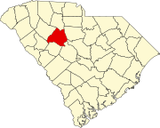
Newberry County is a county located in the U.S. state of South Carolina. As of the 2020 census, its population was 37,719. Its county seat is Newberry. The name is of unknown origin, although one theory suggests that it was named by Quaker settlers in honor of their home of Newberry, a suburb of London in the United Kingdom.

<span class="mw-page-title-main">Transylvania County, North Carolina</span> County in North Carolina, United States

Transylvania County is a county in the U.S. state of North Carolina. As of the 2020 census the population is 32,986. Its county seat is Brevard.

<span class="mw-page-title-main">Flat Rock, Henderson County, North Carolina</span> Village in North Carolina, United States

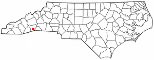
Flat Rock is a village in Henderson County, North Carolina, United States. The population was 3,114 at the 2010 census. It is part of the Asheville Metropolitan Statistical Area.

<span class="mw-page-title-main">Birmingham, Huntingdon County, Pennsylvania</span> Borough in Pennsylvania, United States

Birmingham is a borough in Huntingdon County, Pennsylvania, United States. The population was 90 at the 2020 census. Birmingham is the site of the Birmingham Window, a geologic structure created by a Paleozoic thrust fault. Birmingham's early settler, John Cadwallader, settled on a hill above the Little Juniata River and made plans to establish a large city. Legend among the local residents is that it was once in consideration to be the state capital. In the first several decades of the 19th century, the village grew quickly as a hub for commerce being carried on the Little Juniata River and on the nearby Pennsylvania Canal. By 1850, the Pennsylvania Railroad had passed through the valley. The development of the railroad diminished the importance of Birmingham as a trading hub since the railroad's nearby hubs in Tyrone and Altoona grew quickly on land that was better suited for development.

<span class="mw-page-title-main">Jonestown, Lebanon County, Pennsylvania</span> Borough in Pennsylvania, United States

Jonestown, previously known as Williamsburg, is a borough in Lebanon County, Pennsylvania, United States. It is part of the Lebanon metropolitan statistical area. The population was 1,629 at the 2020 census.

<span class="mw-page-title-main">Aiken, South Carolina</span> City in South Carolina, United States

Aiken is the most populous city in, and the county seat of, Aiken County, South Carolina, United States. According to 2020 census, the population was 32,025, making it the 15th-most populous city in South Carolina, and one of the two largest cities of the Central Savannah River Area.

<span class="mw-page-title-main">Winnsboro, South Carolina</span> Town in South Carolina, United States

Winnsboro is a town in Fairfield County, South Carolina, United States. The population was 3,550 at the 2010 census. The population was 3,215 at the 2020 census, a population decrease of approximately 9.5% for the same 10 year period. It is the county seat of Fairfield County. Winnsboro is part of the Columbia, South Carolina metropolitan Area as well as a suburb of Columbia.

<span class="mw-page-title-main">Clinton, South Carolina</span> City in South Carolina, United States

Clinton is a city in Laurens County, South Carolina, United States. The population was 8,490 as of the 2010 census. It is part of the Greenville–Mauldin–Easley Metropolitan Statistical Area in upstate South Carolina. Clinton is the home of Presbyterian College.

<span class="mw-page-title-main">Laurens, South Carolina</span> City in South Carolina, United States

Laurens is a city in Laurens County, South Carolina, United States. The population was 9,139 at the 2010 census. It is the county seat of Laurens County.

<span class="mw-page-title-main">Chapin, South Carolina</span> Town in South Carolina, United States

Chapin, popularly known as the "Capital of Lake Murray", is a small lake town located at the northern tip of Lexington County, South Carolina, United States. Lake Murray separates Chapin from the rest of Lexington County. The population of Chapin was 1,445 according to the 2010 census, and an estimated 1,633 in 2019.

<span class="mw-page-title-main">Lexington, South Carolina</span> Town in South Carolina, USA

Lexington is the most populous town in and the county seat of Lexington County, South Carolina, United States. It is a suburb of the state capital, Columbia. The population was 23,568 at the 2020 Census, and it is the second-most populous municipality in the greater Columbia area. The 2022 estimated population is 24,626. According to the Central Midlands Council of Governments, the greater Lexington area had an estimated population of 111,549 in 2020 and is considered the fastest-growing area in the Midlands. Lexington's town limits are bordered to the east by the city of West Columbia.

<span class="mw-page-title-main">Newberry, South Carolina</span> City in South Carolina, United States

Newberry is a city in Newberry County, South Carolina, United States, in the Piedmont 43 miles northwest of Columbia. The charter was adopted in 1894. The population was 10,277 at the 2010 census. It is the county seat of Newberry County; at one time it was called Newberry Courthouse.

<span class="mw-page-title-main">Peak, South Carolina</span> Town in South Carolina, United States

Peak is a town in Newberry County, South Carolina, United States. The population was 64 at the 2010 census.

<span class="mw-page-title-main">Prosperity, South Carolina</span> Town in South Carolina, United States

Prosperity is a town in Newberry County, South Carolina, United States. The population was 1,178 at the 2020 U.S. census.

<span class="mw-page-title-main">Silverstreet, South Carolina</span> Town in South Carolina, United States

Silverstreet is a town in Newberry County, South Carolina, United States. The population was 162 at the 2010 census. Arguably its biggest tourist attraction is its Thunderbolt siren, tested on the 4th Saturday of every month for three minutes, and one of the only active Thunderbolts left In the state of South Carolina. With there only being five others remaining.

<span class="mw-page-title-main">Whitmire, South Carolina</span> Town in South Carolina, United States

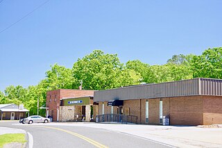
Whitmire is a town in Newberry County, South Carolina, United States, along the Enoree River. The population was 1,441 at the 2010 census. The town was named for George Fredrick Whitmire, who came from Stuttgart, Germany.

<span class="mw-page-title-main">York, South Carolina</span> City in South Carolina, United States

York is a city in and county seat of York County, South Carolina, United States. The population was approximately 6,985 at the 2000 census and up to 7,736 at the 2010 census. York is located approximately 27 miles (43 km) southwest of Charlotte, North Carolina and 13 miles (21 km) west of Rock Hill, South Carolina.

<span class="mw-page-title-main">Batesburg-Leesville, South Carolina</span> Town in South Carolina, United States

Batesburg-Leesville is a town located in Lexington and Saluda counties, South Carolina, United States. The town's population was 5,362 as of the 2010 census and an estimated 5,415 in 2019.

<span class="mw-page-title-main">Irmo, South Carolina</span> Town in South Carolina, United States

Irmo is a town in Lexington and Richland counties, South Carolina, United States and a suburb of Columbia. It is part of the Columbia Metropolitan Statistical Area and is located 12 miles (19 km) northwest of the city center. The population of Irmo was 11,097 at the 2010 census.

<span class="mw-page-title-main">Midlands of South Carolina</span>

The Midlands region of South Carolina is the middle area of the state. The region's main center is Columbia, the state's capital. The Midlands is so named because it is halfway point between the Upstate and the Lowcountry. The main area code is 803.

References

  1. "ArcGIS REST Services Directory". United States Census Bureau. Retrieved October 15, 2022.
  2. 1 2 U.S. Geological Survey Geographic Names Information System: Little Mountain, South Carolina
  3. 1 2 "Census Population API". United States Census Bureau. Retrieved October 15, 2022.
  4. "U.S. Census website". United States Census Bureau . Retrieved January 31, 2008.
  5. Gannett, Henry (1905). The Origin of Certain Place Names in the United States. U.S. Government Printing Office. p.  188.
  6. "National Register Information System". National Register of Historic Places . National Park Service. July 9, 2010.
  7. 1 2 Brown, Robbie (December 27, 2012). "One-Stoplight Town Seeks Just One Mayor". The New York Times . Manhattan, New York . Retrieved December 28, 2012.
  8. "US Gazetteer files: 2010, 2000, and 1990". United States Census Bureau. February 12, 2011. Retrieved April 23, 2011.
  9. "Station Name: SC LITTLE MTN". National Oceanic and Atmospheric Administration . Retrieved March 5, 2021.
  10. "NOWData - NOAA Online Weather Data". National Oceanic and Atmospheric Administration . Retrieved March 5, 2021.
  11. "Census of Population and Housing". Census.gov. Retrieved June 4, 2015.
  12. Netzel, Natalie (February 27, 2013). "Little Mountain welcomes Jayroe as mayor". Newberry Observer. Archived from the original on June 29, 2013. Retrieved April 17, 2013.
  13. Netzel, Natalie (2012). "Reunion Association debating reunion's fate". Newberry Observer. Archived from the original on February 16, 2013. Retrieved January 20, 2013.