Silverstreet, South Carolina

Last updated

Silverstreet, South Carolina
Silverstreet-Main-St-sc.jpg
Main Street (SC 34)
SCMap-doton-Silverstreet.PNG
Location of Silverstreet, South Carolina
Coordinates: 34°13′4″N81°42′48″W / 34.21778°N 81.71333°W / 34.21778; -81.71333
Country United States
State South Carolina
County Newberry
Area
[1]
  Total3.35 sq mi (8.67 km2)
  Land3.35 sq mi (8.67 km2)
  Water0.00 sq mi (0.00 km2)
Elevation
[2]
489 ft (149 m)
Population
 (2020) [3]
  Total164
  Density48.98/sq mi (18.91/km2)
Time zone UTC-5 (Eastern (EST))
  Summer (DST) UTC-4 (EDT)
ZIP code
29145
Area code(s) 803, 839
FIPS code 45-66400 [4]
GNIS feature ID1226626 [2]
Website sites.google.com/site/townofsilverstreet/

Silverstreet is a town in Newberry County, South Carolina, United States. The population was 162 at the 2010 census. Arguably its biggest tourist attraction is its Thunderbolt siren, tested on the 4th Saturday of every month for three minutes, and one of the only active Thunderbolts left In the state of South Carolina. With there only being five others remaining.

Contents

Geography

Silverstreet is located at 34°13′4″N81°42′48″W / 34.21778°N 81.71333°W / 34.21778; -81.71333 (34.217657, -81.713229). [5] The town is located along South Carolina Highway 34 west of Newberry and just north of the Saluda River. Lake Murray lies to the southeast, and Lake Greenwood lies to the northwest.

According to the United States Census Bureau, the town has a total area of 3.5 square miles (9.1 km2), all land.

Demographics

Historical population
CensusPop.Note
1920 297
1930 221−25.6%
1940 146−33.9%
1950 20137.7%
1960 181−10.0%
1970 156−13.8%
1980 20028.2%
1990 156−22.0%
2000 21638.5%
2010 162−25.0%
2020 1641.2%
U.S. Decennial Census [6] [3]

As of the census [4] of 2000, there were 216 people, 83 households, and 58 families residing in the town. The population density was 61.4 inhabitants per square mile (23.7/km2). There were 92 housing units at an average density of 26.2 per square mile (10.1/km2). The racial makeup of the town was 83.33% White, 14.35% African American, and 2.31% from two or more races. Hispanic or Latino of any race were 1.85% of the population.

There were 83 households, out of which 31.3% had children under the age of 18 living with them, 55.4% were married couples living together, 9.6% had a female householder with no husband present, and 30.1% were non-families. 27.7% of all households were made up of individuals, and 18.1% had someone living alone who was 65 years of age or older. The average household size was 2.60 and the average family size was 3.17.

In the town, the population was spread out, with 24.5% under the age of 18, 7.9% from 18 to 24, 29.2% from 25 to 44, 17.6% from 45 to 64, and 20.8% who were 65 years of age or older. The median age was 37 years. For every 100 females, there were 81.5 males. For every 100 females age 18 and over, there were 79.1 males.

The median income for a household in the town was $27,321, and the median income for a family was $43,750. Males had a median income of $24,063 versus $14,861 for females. The per capita income for the town was $17,184. About 7.7% of families and 7.6% of the population were below the poverty line, including 4.9% of those under the age of eighteen and 17.8% of those 65 or over.

Related Research Articles

<span class="mw-page-title-main">Newberry County, South Carolina</span> County in South Carolina, United States

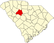
Newberry County is a county located in the U.S. state of South Carolina. As of the 2020 census, its population was 37,719. Its county seat is Newberry. The name is of unknown origin, although one theory suggests that it was named by Quaker settlers in honor of their home of Newberry, a suburb of London in the United Kingdom.

<span class="mw-page-title-main">Newberry, Indiana</span> Town in Indiana, United States

Newberry is a town in Cass Township, Greene County, Indiana, United States. The population was 193 at the 2010 census. It is part of the Bloomington, Indiana Metropolitan Statistical Area.

<span class="mw-page-title-main">Donalds, South Carolina</span> Town in South Carolina, United States

Donalds is a town in Abbeville County, South Carolina. As of the 2020 United States Census, its population was 328.

<span class="mw-page-title-main">Burnettown, South Carolina</span> Town in South Carolina, United States of America

Burnettown is a town in Aiken County, South Carolina, United States. The population was 3,105 at the 2020 census. It is part of the Augusta, Georgia metropolitan area. Burnettown is located in historic Horse Creek Valley.

<span class="mw-page-title-main">Windsor, South Carolina</span> Town in South Carolina, United States of America

Windsor is a town in Aiken County, South Carolina, United States. The population was 121 at the 2010 census. It is part of the Augusta, Georgia metropolitan area.

<span class="mw-page-title-main">Chesterfield, South Carolina</span> Town in South Carolina, United States

Chesterfield is a town in Chesterfield County, South Carolina, United States. The population was 1,472 at the 2010 census. It is the county seat of Chesterfield County. At the time of the 2010 census, Chesterfield was the least populous of all of South Carolina's county seats.

<span class="mw-page-title-main">Joanna, South Carolina</span> Census-designated place in South Carolina, United States

Joanna is an unincorporated community and census-designated place (CDP) in Laurens County, South Carolina, United States. The population was 1,539 at the 2010 census, down from 1,609 at the 2000 census. It is part of the Greenville–Mauldin–Easley Metropolitan Statistical Area.

<span class="mw-page-title-main">Summit, South Carolina</span> Town in South Carolina, United States

Summit is a town in Lexington County, South Carolina, United States. The population was 402 at the 2010 census. It is part of the Columbia, South Carolina Metropolitan Statistical Area.

<span class="mw-page-title-main">Newberry, South Carolina</span> City in South Carolina, United States

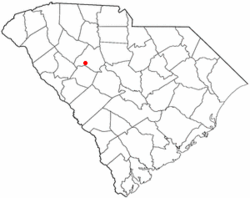
Newberry is a city in Newberry County, South Carolina, United States, in the Piedmont 43 miles northwest of Columbia. The charter was adopted in 1894. The population was 10,277 at the 2010 census. It is the county seat of Newberry County; at one time it was called Newberry Courthouse.

<span class="mw-page-title-main">Peak, South Carolina</span> Town in South Carolina, United States

Peak is a town in Newberry County, South Carolina, United States. The population was 64 at the 2010 census.

<span class="mw-page-title-main">Pomaria, South Carolina</span> Town in South Carolina, United States

Pomaria is a town in Newberry County, South Carolina, United States. The population was 179 at the 2010 census.

<span class="mw-page-title-main">Prosperity, South Carolina</span> Town in South Carolina, United States

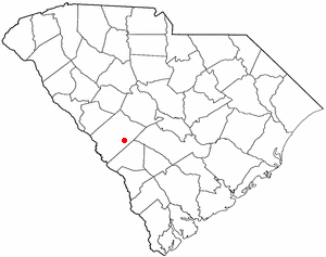
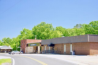
Prosperity is a town in Newberry County, South Carolina, United States. The population was 1,178 at the 2020 U.S. census.

<span class="mw-page-title-main">Whitmire, South Carolina</span> Town in South Carolina, United States

Whitmire is a town in Newberry County, South Carolina, United States, along the Enoree River. The population was 1,441 at the 2010 census. The town was named for George Fredrick Whitmire, who came from Stuttgart, Germany.

<span class="mw-page-title-main">West Union, South Carolina</span> Town in South Carolina, United States

West Union is a town in Oconee County, South Carolina, United States. Although its name suggests that it is near Union, they are approximately four counties apart. The population was 291 at the 2010 census.

<span class="mw-page-title-main">St. Andrews, South Carolina</span> Census-designated place in South Carolina, United States

St. Andrews is a census-designated place (CDP) in Richland County, South Carolina, United States. The population was 20,493 at the 2010 census. It is part of the Columbia, South Carolina Metropolitan Statistical Area.

<span class="mw-page-title-main">Central Pacolet, South Carolina</span> Town in South Carolina, United States

Central Pacolet is a town in Spartanburg County, South Carolina, United States, along the Pacolet River. The population was 216 at the 2010 census.

<span class="mw-page-title-main">Jonesville, South Carolina</span> City in South Carolina, United States

Jonesville is a town in Union County, South Carolina, United States. The population was 911 at the 2010 United States Census.

<span class="mw-page-title-main">McConnells, South Carolina</span> Town in South Carolina, United States

McConnells is a town in York County, South Carolina, United States and a suburb of York. The population was 255 at the 2010 census.

<span class="mw-page-title-main">Sharon, South Carolina</span> Town in South Carolina, United States

Sharon is a town in southwestern York County, South Carolina, United States. The population was 494 at the 2010 census.

<span class="mw-page-title-main">Huttonsville, West Virginia</span> Town in West Virginia, United States

Huttonsville is a town in Randolph County, West Virginia, United States, along the Tygart Valley River. The population was 163 at the 2020 census.

References

  1. "ArcGIS REST Services Directory". United States Census Bureau. Retrieved October 15, 2022.
  2. 1 2 U.S. Geological Survey Geographic Names Information System: Silverstreet, South Carolina
  3. 1 2 "Census Population API". United States Census Bureau. Retrieved October 15, 2022.
  4. 1 2 "U.S. Census website". United States Census Bureau . Retrieved January 31, 2008.
  5. "US Gazetteer files: 2010, 2000, and 1990". United States Census Bureau. February 12, 2011. Retrieved April 23, 2011.
  6. "Census of Population and Housing". Census.gov. Retrieved June 4, 2015.