Little Sugar Creek Greenway

Last updated
Little Sugar Creek Greenway
Little Sugar Creek Greenway at 4th Street.jpg
Looking south at E 4th Street overpass
Little Sugar Creek Greenway
Type Greenway
Location Charlotte, North Carolina
Coordinates 35°12′27″N80°50′11″W / 35.2075°N 80.8365°W / 35.2075; -80.8365
Operated by Mecklenburg County Parks and Recreation
Website Little Sugar Creek Greenway

Little Sugar Creek Greenway is a linear park and stream restoration project in Mecklenburg County, North Carolina. [1] When completed it will consist of twenty miles of trails and paved walkways running from Cordelia Park just north of uptown Charlotte, then south through midtown Charlotte, and continuing all the way to the South Carolina state line. [2] The Little Sugar Creek Greenway is a key part of the Cross Charlotte Trail (XCLT) and a segment in the Carolina Thread Trail, a regionwide network of trails that pass through 15 counties. [3]

Contents

Greenways are narrow strips of land, planted and managed to provide both human recreation and wildlife habitat. Greenways along streams, such as Little Sugar Creek, improve water quality and help control flooding. There are about 37 miles of developed greenways in Mecklenburg County, of which this is only one. [4]

The two urban sections of the Little Sugar Creek Greenway were championed by Central Piedmont Community College president Tony Zeiss and together provide five unbroken miles of paved walkway from East 7th Street southward to Brandywine Road. [5] [6]

History

Little Sugar Creek

Unlike many large cities, Charlotte is not sited on or near a sea, lake, or significant river; its hydrogeography is based on small streams and creeks, Little Sugar Creek being perhaps the most prominent. The name of Little Sugar Creek (which has also been called Sugar Creek, a name that has also been applied to what is now called Irwin Creek) derives from the Sugaree tribe indigenous to the area. [7]

Running through some of Charlotte's oldest neighborhoods, over time parts of Little Sugar Creek became hidden by houses, factories, parking lots, riprap, highways, and culverts. [7] The stream also became very polluted by runoff from factories and sewers, and litter. [8]

Controlled flooding on Little Sugar Creek in December 2015. In the 1990s floods caused extensive damage along the Sugar Creek watershed. Little Sugar Creek flooding on 12-31-15.jpg
Controlled flooding on Little Sugar Creek in December 2015. In the 1990s floods caused extensive damage along the Sugar Creek watershed.

As recently as 2000 Little Sugar Creek was "the most polluted stream in Charlotte-Mecklenburg, a fetid stew of runoff and industrial waste trickling beneath parking decks and buildings on the fringe of downtown." [5] Businesses dumped waste straight into its water, the fumes so noxious they were said to peel the paint off nearby buildings. [9] Moreover, flood-prone buildings had to be razed, and much of the stream was covered by concrete which had to be removed. [10] The pollution problem began to be solved when straight-piping of wastes was outlawed in 1998; nevertheless Little Sugar Creek Greenway became the most expensive stream restoration in Mecklenburg county. [9]

The Greenway

In 1968 Charlotte city council member Jerry Tuttle, inspired by San Antonio's River Walk, proposed an urban "Charlotte waterfront" on Sugar Creek. [5] In 1974 the Mecklenburg County Park and Recreation Commission first studied the feasibility of a greenway system. A master plan was created in 1980 involving 20 creeks and streams. The final report was based on the graduate thesis for Joan Sigmon, a geography major at the University of North Carolina at Charlotte. [11] The idea of a comprehensive greenway system was also promoted by Mecklenburg county commissioner Tom Ray who authored the concept known as "Sugar Creek Projection 70". [12]

Demographics provided further impetus for preserving green space in the center city. Bucking the general trend, Charlotte experienced growth in the central core while other cities were losing population to the suburbs. As a result, "The Mecklenburg County Parks and Recreation Department embarked on an ambitious update to its earlier 1980 and 1991 Greenways Plans to not only extend and create new greenway corridors, but also improve established corridors." [13]

Finally, in 1999 a bond plan was approved; the money was used to buy property along the stream bed, begin construction or paved walkways, restore wetlands, build water gardens, and generally launch a major stream restoration project. In the end, the urban section of the Little Sugar Creek Greenway cost $43 million. [2] [5]

Although the master plan remained the guideline, little was done until 2000 when a 10-year growth plan was formulated. [9]

The North Carolina Department of Transportation announced the completion of the Charlotte portion of the Little Sugar Creek Greenway at a celebration on April 24, 2012. [14]

Finished sections

The completed parts of the Little Sugar Creek Greenway can be divided into two major sections going downstream from north to south. The longest continuous segments run from 7th Street to Brandywine Road and from Tyvola Road to President James K. Polk State Historic Site. In December 2019 construction began on the final segment connecting Brandywine Road and Tyvola Road. [15]

Cordelia Park to 12th Street

A paved walkway follows Little Sugar Creek and extends for .95 miles from Parkwood Avenue on the southern border of Cordelia Park to Greenway Crescent Lane and East 12th street just south of Alexander Street Park. Gulf Coast spiny softshell turtles can be seen in this part of the creek. [16] An overland route that follows 10th street to North McDowell street to 7th street provides connectivity to the southern part of the greenway. The overland route will be replaced by a dedicated segment. [17]

Stream restoration on urban Section of the Greenway Stream restoration on urban Section of Little Sugar Creek Greenway, Charlotte, NC.jpg
Stream restoration on urban Section of the Greenway

East 7th Street to Morehead Street

The "urban section" of the greenway runs for 1.29 miles along Sugar Creek in uptown Charlotte and was completed in April 2012. [18] It begins at 7th Street, goes southward past Central Piedmont Community College, [19] passes through Thompson Park, connects to the showpiece Midtown Park at Pearl Park Way, [20] and ends at the Morehead Street underpass. It is the most highly developed section of the greenway and incorporates paved walkways, stonework walls and plazas, fountains, dining, many newly planted trees, large decorative rocks, gardens, public event areas, numerous statues and sculptures, and a clock tower. [21] There are overpasses and underpasses to facilitate unimpeded walking and biking. [22] Included also are the usual park amenities such as benches, bike racks, restrooms, decorative lampposts, and a snack stand. [23]

Liz Hair Nature Walk Liz Hair Nature Walk 1, Charlotte, NC.jpg
Liz Hair Nature Walk

Morehead Street to Brandywine Road

This section connects with the urban section through the Morehead Street underpass. The first part going south is a straight section directly on the banks of Sugar Creek known as the Liz Hair Nature Walk, completed in September 2005. [24] It extends for .65 miles from Morehead Street to East Boulevard and is adjacent to the Carolinas Medical Center complex. The next section runs from East Boulevard to Princeton Avenue, passing by the Charlotte Nature Museum and through Freedom Park. Next is a so-called overland connector which utilizes existing sidewalk for .42 miles along Jameston Drive. The paved part of the greenway resumes again at Hillside Avenue and continues on to Brandywine Road, ending behind the Park Road Shopping Center. This last section features wetland filtration ponds and explanatory signage. [25]

Greenway trail in Huntingtowne Farms Park Little Sugar Creek Greenway in Huntingtowne Farms Park, Charlotte, NC.jpg
Greenway trail in Huntingtowne Farms Park

Tyvola Road to Huntingtowne Farms Park

Completed in 2018, this 1.5 mile section connects Marion Diehl Park and the Madison Park neighborhood to Park Road Park, Huntingtowne Farms Park, and the Backyard Trails network—an extensive mountain biking trail network maintained by Tarheel Trailblazers. [26] This segment also passes by the Sugar Creek Wastewater Treatment Plant. [27]

Huntingtowne Farms Park to I-485

In 2020 the .79 mile segment of the greenway located in Huntingtowne Farms Park was expanded to 2.2 miles providing connectivity to I-485 and Carolina Pavilion. [28] This expansion included access from the Park Crossing and Starmount neighborhoods. This segment of the greenway is known as a haven for hawks and barred owls. [29]

I-485 to President James K. Polk State Historic Site

In 2021 an additional 1.8 miles of the greenway was open. This segment continued the greenway south from I-485 to the President James K. Polk State Historic Site in Pineville, North Carolina. [8] This segment provides connectivity to Marsh Park and Carolina Place Mall. [30] The final southern segment of The Little Sugar Creek Greenway will extend 3.3 miles from this segment at the President James K. Polk State Historic Site to the South Carolina State border. [31]

President James K. Polk Historic Site to South Carolina state line

This greenway section runs from President James K. Polk Historic Site in Pineville NC all the way to Gilroy Dr in Indian Land SC/Regent Park Fort Mill SC area. This greenway extension provides connectivity within several communities and makes easy access to Charlotte NC/Pineville NC. This greenway also makes accessing parks and other greenways easy. This greenway not only improved the conditions of Little Sugar Creek in Pineville, it improves the lifestyle of residents within Mecklenburg County, NC and other surrounding counties such as York County, SC and Lancaster County, SC.

Trail of History

The Trail of History is a collection of privately subsidized bronze statues situated in midtown (between 7th Street and Morehead Street) along the Little Sugar Creek Greenway. The statues are intended to commemorate individuals who contributed to the history of Charlotte and Mecklenburg County. In 2005 the first statue of Captain James Jack, a legendary figure in the story of the Mecklenburg Declaration of Independence, was installed in Elizabeth Park. [32]

As of 2021, eight statues have been installed with accompanying information plaques. Additional individuals include: Thomas Spratt & King Hagler, James Buchanan Duke, Jane Wilkes, among others.

Statues include works from notable artists such as: Jane DeDecker, Ed Dwight, Chas Fagan, and Antonio Tobias Mendez. [33]

Reviews

Gene Conti of the North Carolina Department of Transportation praised the greenway "for providing Charlotteans with an accessible place to run, walk and bike," and called it "an example for the rest of the state." [14] The Charlotte Observer called the Little Sugar Creek Greenway a "sweet resurrection". Fish have returned to the stream; and ducks, Canada geese, and herons are often seen. [5] [34] The mixture of natural restoration and urban redevelopment draws "gushing praise"—although some people, such as Mecklenburg County commissioner Bill James, have criticized the project for its cost. James compared the project to proposed uptown baseball stadiums, asserting that the county overpaid for land for stream restoration and helped "well-connected developers". However, one business owner said that sites along the greenway offer the "best view of Charlotte from Charlotte—a view that will remain unencumbered forever." [9]

Despite being a vast improvement over the toxic pollution of the past, trash–particularly plastic bags-remains a problem along Sugar Creek. In 2015 Richard Maschal of the Charlotte Observer reported, "The creek is festooned with such detritus, particularly near the bridges spanning Morehead Street and Kings Drive." [34]

Awards

Activities

Related Research Articles

<span class="mw-page-title-main">Charlotte, North Carolina</span> Largest city in North Carolina, United States

Charlotte is the most populous city in the U.S. state of North Carolina and the county seat of Mecklenburg County. The population was 874,579 at the 2020 census, making Charlotte the 15th-most populous city in the United States, the seventh-most populous city in the South, and the second-most populous city in the Southeast behind Jacksonville, Florida. The city is the cultural, economic, and transportation center of the Charlotte metropolitan area, whose estimated 2023 population of 2,805,115 ranked 22nd in the United States. Metrolina is part of an eighteen-county market region or combined statistical area with an estimated 2023 population of 3,387,115.

<span class="mw-page-title-main">Mecklenburg County, North Carolina</span> County in North Carolina, United States

Mecklenburg County is a county located in the southwestern region of the U.S. state of North Carolina, in the United States. As of the 2020 census, the population was 1,115,482, making it the second-most populous county in North Carolina, and the first county in the Carolinas to surpass one million in population. Its county seat is Charlotte, the state's largest municipality.

<span class="mw-page-title-main">Pineville, North Carolina</span> Town in North Carolina, United States

Pineville is a suburban town in the southernmost portion of Mecklenburg County, North Carolina, United States. Part of the Charlotte metropolitan area, it is situated in the Waxhaws district between Charlotte and Fort Mill.

<span class="mw-page-title-main">American Tobacco Trail</span>

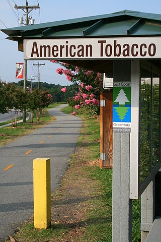
The American Tobacco Trail (ATT) is a 22.6-mile (36.4 km) long Rails-to-Trails project located in the Research Triangle region of North Carolina, running along an abandoned railroad bed originally built for the American Tobacco Company in the 1970s. The route crosses through portions of Durham County, Chatham County, and Wake County. The ATT is part of the East Coast Greenway and is open to pedestrians, cyclists, equestrians and other non-motorized users.

<span class="mw-page-title-main">East Coast Greenway</span> Long-distance hiking trail in the United States

The East Coast Greenway is a 3,000-mile (4,800 km) pedestrian and bicycle route between Maine and Florida along the East Coast of the United States. The nonprofit East Coast Greenway Alliance was created in 1991 with the goal to use the entire route with off-road, shared-use paths; as of 2021, over 1,000 mi (1,600 km) of the route (35%) meets these criteria. In 2020, the Greenway received over 50 million visits.

<span class="mw-page-title-main">Interstate 485</span> Beltway around Charlotte, NC

Interstate 485 (I-485) is a 66.68-mile-long (107.31 km) auxiliary Interstate Highway encircling Charlotte, North Carolina. As a complete loop, it is primarily signed with "inner" and "outer" designations, though at some major interchanges, supplemental signage reflects the local compass orientation of the road. The entire route lies within Mecklenburg County.

<span class="mw-page-title-main">Midtown Greenway</span> Shared-use path in Minneapolis, USA

The Midtown Greenway is a 5.7-mile (9.2 km) rail trail in Minneapolis, Minnesota that follows the path of an abandoned route of the Milwaukee Road railway. It is considered under segregated cycle facilities.

<span class="mw-page-title-main">Greenway (landscape)</span> Shared-use path or linear park with vegetation

A greenway is usually a shared-use path along a strip of undeveloped land, in an urban or rural area, set aside for recreational use or environmental protection. Greenways are frequently created out of disused railways, canal towpaths, utility company rights of way, or derelict industrial land. Greenways can also be linear parks, and can serve as wildlife corridors. The path's surface may be paved and often serves multiple users: walkers, runners, bicyclists, skaters and hikers. A characteristic of greenways, as defined by the European Greenways Association, is "ease of passage": that is that they have "either low or zero gradient", so that they can be used by all "types of users, including mobility impaired people".

<span class="mw-page-title-main">Charlotte Route 4</span>

Route 4 is an 18.6-mile (29.9 km) partial ring road located in Charlotte, North Carolina. Beginning and ending at Interstate 85 (I-85), it loops south around Uptown Charlotte along state-maintained secondary roads, connecting the Charlotte Douglas International Airport and several city neighborhoods including Madison Park, Myers Park, Windsor Park and Sugar Creek. The route is posted by the Charlotte Department of Transportation (CDOT), using a modified pentagonal county road shield, with a green background and the city's crown logo above the number. The loop has a radius of about 4 miles (6.4 km), hence the number.

<span class="mw-page-title-main">Freedom Park (Charlotte, North Carolina)</span>

Freedom Park is a 98-acre park in Charlotte, North Carolina. Located at 1900 East Boulevard, between Charlotte's historic Dilworth and Myers Park neighborhoods, the park is centered on a 7-acre lake, and is about 3 miles (4.8 km) from the heart of Charlotte's downtown area.

The transportation needs for the city of Charlotte, North Carolina are served by an expanding mass transit system, major airport, and several highways.

<span class="mw-page-title-main">Trails in Detroit</span>

This is a list of trails and greenways in Detroit.

<span class="mw-page-title-main">Parks and Greenways in Huntsville</span>

An extensive collection of parks and greenways exists in Huntsville, Alabama for the public's recreational use.

<span class="mw-page-title-main">Ray's Splash Planet</span> Water park in Charlotte, North Carolina

Ray's Splash Planet is a Mecklenburg County, North Carolina funded water park located in Charlotte, North Carolina, United States. The aquatic facility is operated by the Mecklenburg County Park and Recreation department. Ray's Splash Planet is considered one of the largest indoor water parks in both of the Carolinas and is the largest water park in Charlotte, North Carolina, with over 29,000 square feet of space and using over 117,000 gallons of water at 87 degrees. The water is cleaned and sanitized through the use of chlorine, filtration and an ultraviolet germicidal irradiation system. There are multiple attractions including the Blue Comet, a three-story figure 8 slide, and other family friendly attractions like the Orbiter, Saturation Station, the Vortex, Meteor Showers, Moon Beach and the Sea of Tranquility. The water park also features a fitness center and gymnasium shared with the Irwin Academic Center, an educational center of the Charlotte-Mecklenburg Schools system. The first floor of the facility includes the pool area, locker rooms, birthday party classrooms and concessions stand. The second story includes the fitness center with an aerobics/dance studio. Access to the indoor gymnasium is also located on the second floor. Ray's Splash Planet is located on North Sycamore Street near Johnson & Wales University and is just off Interstate 77 in North Carolina in the Third Ward section of Uptown Charlotte. The water park opened on October 15, 2002 with help from Mecklenburg County Park and Recreation's partnership with Charlotte-Mecklenburg Schools. Major competitors are Carowinds in Charlotte, North Carolina, Great Wolf Lodge in Concord, North Carolina and Wet 'n Wild Emerald Pointe in Greensboro, North Carolina.

<span class="mw-page-title-main">Midtown Park (Charlotte, North Carolina)</span>

Midtown Park is a one acre minipark at South Kings Drive and Pearl Park Way in Charlotte, North Carolina. Opened in the spring of 2012, it contains stonework and shade trees surrounding a rectangular lawn and is suitable for weddings as well as performance art and other public events. The park features several sculptures, including a seven foot diameter spherical metallic piece called the Braille Music Box by artists Po Shu Wang and Louise Bertelsen. A unique feature of the sculpture is that it can be enjoyed by the sight-impaired. It contains a mechanism which can translate Braille letters into musical notes, and visitors can move the music box within the sculpture to hear this unique music.

<span class="mw-page-title-main">Clanton Park (Charlotte, North Carolina)</span> Urban park in Charlotte, North Carolina, U.S.

Clanton Park is a 77-acre urban park at 1520 Clanton Road in the West Boulevard neighborhood of Charlotte, North Carolina. It features playgrounds, fields for soccer and softball, eleven basketball courts, picnic shelters, and a gazebo. The park also manages the nearby Clanton community pavilion, a 4,500 square foot indoor facility at 3132 Manchester Avenue. A half-mile section of the Irwin Creek Greenway runs through Clanton Park.

<span class="mw-page-title-main">Thomas Polk</span> Revolutionary War officer and politician

Thomas Polk was a planter, military officer in the Continental Army during the American Revolutionary War from 1775 to 1781, and a politician who served in the North Carolina House of Commons, North Carolina Provincial Congress, and Council of State. Polk commanded the 4th North Carolina Regiment in the Battle of Brandywine. In 1786, Polk was elected by the North Carolina General Assembly to the Congress of the Confederation, but did not attend any of its sessions. Polk was a great-uncle of the 11th President of the United States, James K. Polk.

<span class="mw-page-title-main">Lynx Blue Line</span> Light rail line in Charlotte, NC

The Lynx Blue Line is a light rail line in Charlotte, North Carolina, United States. Opened in 2007, it was the first rail line of the Charlotte Area Transit System, and the first major rapid rail service of any kind in the state. The 26-station, 19.3-mile (31.1 km) line extends from its northern terminus at the University of North Carolina at Charlotte in University City through NoDa, Uptown, and South End, then runs along South Boulevard to its southern terminus just north of Interstate 485 at the Pineville city limits. The line carries an average of over 27,700 passenger trips every day and offers connections to the CATS' CityLynx Gold Line which opened in 2015.

<span class="mw-page-title-main">Cherry (Charlotte neighborhood)</span> Neighborhood in Mecklenburg County, North Carolina, United States

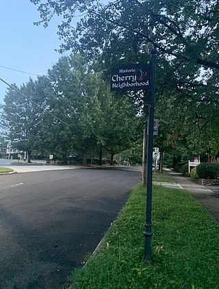
Cherry is a historical African-American neighborhood in Charlotte, North Carolina. Adjacent to Uptown Charlotte, it is bounded within Little Sugar Creek, Kenilworth Avenue, John Belk Freeway, East 4th Street, Queens Road, and Henley Place.

References

  1. Little Sugar Creek Greenway connects urban spaces with nature, by Jennifer Ford, April 20, 2012
  2. 1 2 "Mecklenburg County Park and Recreation: Little Sugar Creek Greenway". Archived from the original on 2012-05-09. Retrieved 2012-05-29.
  3. "Carolina Thread Trail Fact Sheet" (PDF). Carolina Thread Trail. Carolina Thread Trail. Retrieved 22 September 2021.
  4. Mecklenburg County Park and Recreation: Greenways
  5. 1 2 3 4 5 Take a walk on the artsy, wild side of the greenway, by Mark Washburn, April 27, 2012
  6. Map of Little Sugar Creek Greenway from E 7th Street to E Morehead Street, PDF file
  7. 1 2 Mary Newsom (March 26, 2015). "Little Sugar: The creek the city loved to hate". Keeping Watch. Retrieved March 30, 2015.
  8. 1 2 Little Sugar Creek Greenway: A Photo Essay from Pineville to NoDa Photographs by Chris Edwards, Charlotte Magazine, September 17, 2023
  9. 1 2 3 4 Charlotte Observer: Sweet resurrection for Charlotte’s Little Sugar Creek, by Bruce Henderson, March 18, 2012 Archived April 2, 2015, at the Wayback Machine
  10. Charlotte-Mecklenburg Storm Water Services: Little Sugar Creek: Charlottetowne Ave to Pearl Park Way (Midtown)
  11. Charlotte-Mecklenburg Historic Landmarks Commission: Greenways and a Return to Landscape Ideology
  12. Mecklenburg County Park and Recreation: History of Sugar Creek
  13. American Planning Association, City Parks Forum: Little Sugar Creek Greenway
  14. 1 2 NCDOT, Charlotte Celebrate Completion of Little Sugar Creek Greenway, April 24, 2012
  15. "Cross Charlotte Trail Segment 02 - Brandywine Road to Tyvola Road". City of Charlotte. City of Charlotte. Retrieved 21 September 2021.
  16. "Little Sugar Creek Greenway: Cordelia Park to 12th Street". Archived from the original on 2012-07-23. Retrieved 2012-06-11.
  17. "Cross Charlotte Trail Segment 03 - 7th Street to 10th Street". City of Charlotte. City of Charlotte. Retrieved 5 June 2021.
  18. Charlotte Observer: Little Sugar Creek Greenway section is done, by April Bethea, April 20, 2012
  19. Charlotte-Mecklenburg Storm Water Services: Little Sugar Creek - 7th St. to Elizabeth Ave. Project
  20. Charlotte Observer: New park to open soon in Midtown, by Karen Sullivan, January 29, 2012
  21. Little Sugar Creek Greenway: East 7th Street to Morehead Street
  22. The Charlotte Observer: SouthPark Magazine: The Great Outdoors, by Sam Boykin, November 22, 2010
  23. WBTV: Statue of Captain James Jack to be Unveiled, May 19, 2010
  24. Little Sugar Creek Greenway: Liz Hair Project
  25. Little Sugar Creek Greenway: Morehead Street to Brandywine Road
  26. "Backyard Trails". Tarheel Trailblazers. Retrieved 5 June 2021.
  27. "Little Sugar Creek Greenway - Tyvola Road to Huntingtowne Farms Park (COMPLETE)". City of Charlotte. City of Charlotte. Retrieved 5 June 2021.
  28. "Little Sugar Creek Greenway - Huntingtowne Farms Park to I 485". City of Charlotte. City of Charlotte. Retrieved 12 June 2021.
  29. Little Sugar Creek Greenway: Huntingtowne Farms Park
  30. "Little Sugar Creek Greenway - I 485 to President James K. Polk State Historic Site". City of Charlotte. City of Charlotte. Retrieved 12 June 2021.
  31. "Little Sugar Creek Greenway - President James K. Polk State Historic Site to South Carolina State Line". City of Charlotte. City of Charlotte. Retrieved 12 June 2021.
  32. "Trail of History". mecknc.gov. Mecklenburg county Park and Recreation. Retrieved 12 June 2021.
  33. "About the Artists". charlottetrailofhistory.org/. Trail of History. Retrieved 12 June 2021.
  34. 1 2 Charlotte Observer: Trash still a problem at Little Sugar Creek Greenway, by Richard Maschal, January 5, 2015
  35. Creative Loafing, Best of Charlotte 2012
  36. Creative Loafing, Best of Charlotte, 2011
  37. Charlotte Magazine: Weekend Top Picks for April 27-29: Kings Drive Art Walk and More, April 23, 2012
  38. Meet Charlotte Newsletter, Spring 2012: URBAN ESCAPE Archived 2012-11-01 at the Wayback Machine
  39. Yelp Reviews: King's Drive Farmer's Market