Interstate 85 in North Carolina

Last updated

I-85.svg

Interstate 85

Interstate 85 in North Carolina
I-85 highlighted in red
Route information
Maintained by NCDOT
Length234.6 mi [1]  (377.6 km)
Existed1958–present
NHSEntire route
Major junctions
South endI-85.svg I-85 at the South Carolina line near Blacksburg, SC
Major intersections
North endI-85.svg I-85 at the Virginia line near Bracey, VA
Location
Country United States
State North Carolina
Counties Cleveland, Gaston, Mecklenburg, Cabarrus, Rowan, Davidson, Randolph, Guilford, Alamance, Orange, Durham, Granville, Vance, Warren
Highway system
NC 84.svg NC 84 NC 86.svg NC 86

Interstate 85 (I-85) is a part of the Interstate Highway System that runs from Montgomery, Alabama, to Petersburg, Virginia. In North Carolina, I-85 travels 231.23 miles (372.13 km) from the South Carolina state line near Grover to the Virginia state line near Wise. Despite being signed north–south, I-85 physically travels in a southwest–northeast direction across the state. The major landscapes traversed by I-85 include urban and rural pockets of the Piedmont region, with views of Kings Pinnacle seen from its southernmost stretch. The Interstate Highway connects the three most populous metropolitan areas of North Carolina: the Charlotte metropolitan area, Piedmont Triad, and Research Triangle, as well as nine of the 20 largest municipalities in the state. Outside of North Carolina, I-85 connects the state with Richmond, Virginia, to the north and Upstate South Carolina and Atlanta, Georgia, to the south. I-85 parallels several US Highways including US Highway 29 (US 29) between South Carolina and Greensboro, US 70 between Greensboro and Durham, US 15 between Durham and Oxford, and US 1 between Henderson and Virginia.

Contents

Route description

I-85 northbound at the exit for US 29/NC 49 in Charlotte I-85 NB at US 29-NC 49 exit.jpeg
I-85 northbound at the exit for US 29/NC 49 in Charlotte

I-85 is maintained by the North Carolina Department of Transportation (NCDOT) for its entire length in the state and designated as a Blue Star Memorial Highway. [2] The Interstate carries an average annual daily traffic volume of approximately 65,000 vehicles a day; roughly 25-40% of that traffic is commercial vehicles. [3] Traffic varies from as much as 181,000 vehicles through Mecklenburg County to as little as 19,000 in Vance County. [4] All of I-85 is a part of the National Highway System, a network of roads important for the country's economy, defense, and mobility. [5] [6]

South Carolina to Charlotte

I-85 enters Cleveland County, North Carolina from Cherokee County, South Carolina near the small town of Grover. Most of the Interstate for its first few miles is generally rural in nature and remains four lanes. It has its first interchange with NC 216, which provides access to Kings Mountain National Military Park, with a welcome center shortly after. Later, the southbound lanes have an exit for US 29, which quietly merges onto I-85 and begins a concurrency. At milemarker 10, the Interstate meets US 74 at a unique weave interchange and US 29 splits off from I-85 for US 74 east. Both routes also enter Kings Mountain. [7]

At this point, I-85 crosses into Gaston County and expands to six lanes from four. It enters suburban areas and traffic begins increasing from here. The Interstate then reaches Gastonia and has an exit for NC 274 (Bessemer City Road). Then it has its first major interchange with US 321, signed north for Lincolnton and south for the city's main business district. Traffic from US 321 south before 2017 was often congested due to I-85, and a new interchange was developed to help relieve it. [8] Past it, I-85 turns southeast, then east as it goes through more suburban areas, with restaurants, businesses, churches, and car dealerships lining the road. Along here, it intersects more state highways serving as Gastonia's main thoroughfares, including NC 7 (Ozark Avenue), NC 279 (New Hope Road), and NC 7 (McAdenville Road/Main Street) again; NC 7 provides access to the town of McAdenville. [9] Here, many major retail stores and supermarkets are seen along I-85 as it continues on its eastward track to Belmont and expands even more to eight lanes. It reaches the main exit for Belmont at NC 273 near milemarker 27, then crosses the Catawba River on the Cameron Morrison Bridge, entering Mecklenburg County. [10]

Charlotte to Greensboro

Right after entering Mecklenburg County, I-85 reaches a weigh station occasionally serving trucks in both directions. Access to the U.S. National Whitewater Center can be done from Sam Wilson Road, its first interchange in the county. After that, I-85 meets I-485 at a stack interchange. This portion of I-85 is often congested due to the lanes merging into one. [11] As of 2024, from the US 321 interchange to I-485, the lanes are being widened to accommodate larger amounts of traffic. [12] Drivers wanting to access I-77 can get off at the interchange, or simply keep driving on I-85 to reach the Charlotte Douglas International Airport. A couple of miles later, I-85 has an exit for the airport via Little Rock Road at a single-point urban interchange and enters the city of Charlotte. It has interchanges with Billy Graham Parkway, as well as two more single-point urban interchanges with NC 27 (Freedom Drive) and NC 16 (Brookshire Boulevard). [13]

I-85 then directly intersects with I-77 and US 21 at milemarker 38 with a hybrid interchange and then traverses the northern portion of Charlotte. The routing through this portion is generally more suburban than urban in nature, with light industries such as truck terminals, warehouses, small manufacturing facilities, and small office parks lining the highway. More interchanges with minor but significant thoroughfares through the city such as Graham Street, Sugar Creek Road, and North Tryon Street appear. Here, I-85 turns northward and enters the University City area. it meets NC 24 (Harris Boulevard) in this stretch and has an interchange with I-485 again, this time at a turbine interchange. [14]

I-85 southbound in Concord near the I-485 interchange Interstate 85 in North Carolina (41368419811).jpg
I-85 southbound in Concord near the I-485 interchange

I-85 then crosses into Cabarrus County, immediately entering the city of Concord and dense commercial development. It passes exit 49 (Bruton Smith Boulevard/Concord Mills Boulevard), which is signed for several major attractions such as the Concord Mills Mall and Charlotte Motor Speedway. [15] Several miles later, it has a diverging diamond interchange with NC 73 and then crosses Coddle Creek. [16] It meets US 29 a second time as well as US 601 nearing Kannapolis, the exit of which US 29 provides access to the North Carolina Research Campus. [17] US 601 merges onto I-85, forming another concurrency as the two routes continue northward and meet a rest area. They do not enter Kannapolis but have several exits signed for it. They cross the Cold Water Creek, which parallels them, before entering Rowan County and mostly rural areas. North of China Grove, the highway passes exit 74 (Julian Road) for an outlet containing several stores. Just before Salisbury, US 601 splits from I-85 at exit 75 for Jake Alexander Boulevard, and I-85 enters Salisbury where it meets US 52 at exit 76 with a single-point urban interchange. US 52 merges onto I-85 and the highway exits Salisbury. At Spencer, I-85/US 52 enters Davidson County and crosses the Yadkin River on the Yadkin River Veterans Memorial Bridge. [18] The route then meets with US 29, US 70, and NC 150 near the unincorporated community of Linwood at an unusual interchange. The interchange allows for direct access to NC 150 northbound and US 29/US 70 southbound. US 29 and US 70 converge with I-85/US 52 for a very brief distance, about two miles (3.2 km), before I-85 reaches an interchange that is accessible northbound only: I-285. At this point, all three U.S. Highways that overlapped I-85 leave the Interstate, and I-85 narrows back down to six lanes. [19]

The landscape becomes more rural as I-85 reaches just outside of Lexington and intersects NC 47 (Hargrave Road). Because the previous exit is northbound-only, drivers going southbound must use NC 47 to access I-285. After its interchange with NC 8 (Cotton Grove Road), which is the main exit for Lexington, I-85 enters a large forest with tree-lined medians and crosses Abbotts Creek, then has an interchange with US 64. Past Holly Grove Road on milemarker 96, the northbound lanes cut under the southbound lanes and cross Hamby Creek. The reversed lanes of I-85 then pass over Squire Bowers Road and reach a rest area, as well as access to the North Carolina Vietnam Veterans Memorial Park. Once the lanes pass under Johnsontown Road around milemarker 102, the northbound lanes cross above the southbound lanes and return to the normal direction. [20] [21]

I-85 southbound at exit 113 for I-74 and NC 62 I-85 South - Exit 113AC - I-74 US311 NC62 Split (49201520983).jpg
I-85 southbound at exit 113 for I-74 and NC 62

The tree-lined median then gives way to the city of Thomasville, where I-85 meets NC 109. It crosses into Randolph County as it enters the city of Archdale and intersects NC 62. I-85 enters High Point and has a parclo interchange with I-74 and the former routing of US 311. The exits are signed east for Asheboro and west for Winston-Salem. I-85 then passes through another forest with more trees lining the median and crosses the Randolph and Guilford branches of the Richland Creek as it enters Guilford County. Just outside Greensboro, it has a southbound interchange with US 29 and US 70 again. US 29 and US 70 form a brief concurrency with I-85 before the route enters suburban areas once more and reaches a very large and complex interchange with Groometown Road, Grandover Parkway, I-73, US 220, and US 421. US 29 and US 70 split off through the interchange, while US 421 joins I-85 from I-73 in a wrong-way concurrency. Because I-85 was rerouted around Greensboro after February 2004, it now follows the southern half of the Greensboro Urban Loop. [22] [23]

Greensboro to Durham

Leaving the massive interchange, I-85/US 421 expands to eight lanes again and stays connected for just 4 miles (6.4 km) before US 421 departs the concurrency at exit 126 to head southeast for Sanford. Prior to the Greensboro Urban Loop, US 421 used to run along exit 126B, which is now signed for just Greensboro itself. Meanwhile, I-85 maintains its northeastward track and passes by a couple more exits before reaching I-785 (its third auxiliary route), I-40, and I-840, the former and latter of which have their southern and eastern terminus at I-85 respectively. [24] I-40 merges onto I-85 and the two routes share a rather long concurrency which travels entirely east–west for 31 miles (50 km). The concurrency here uses I-85's mileage instead of I-40's. I-40/I-85 enters more industrial areas and meets NC 61 before entering Alamance County. It travels right through the heart of Burlington upon mile marker 141, intersecting several of the city's main state highways, including NC 62 again, NC 49, NC 87, and NC 54. Businesses, restaurants, parks, and buildings can be seen lining the sides of the highway. [25] Past a diverging diamond interchange with NC 119 (Mebane-Oaks Road), the highway enters Orange County and reaches another truck weigh station. I-40 then splits off southeast from I-85 to serve the southern portion of Durham and downtown Raleigh while I-85 continues eastward and narrows back down to four lanes. [26]

I-85 northbound passing through Durham 2008-08-23 I-85 NB from Hillandale Rd in Durham.jpg
I-85 northbound passing through Durham

The following interchanges of I-85 before Durham County are rather substandard in quality due to the interstate retaining its original design. It meets NC 86 and later US 70, which forms another concurrency once again before entering Durham County. At milemarker 172, it meets the northern terminus of NC 147 (Durham Freeway), which connects to downtown Durham. I-85/US 70 then widens to six lanes again and then ten as it reaches the main city center and becomes urban in nature. [27] It then has an interchange with US 15 and US 501, which both also join the concurrency. The highway passes NC 157 (Guess Road), and then US 501 splits off at Duke Street to head north. The other three highways continue on their way before meeting the western terminus of NC 55 (Avondale Drive). Just before exiting Durham, US 70 also departs the concurrency to head east alongside I-85's fourth and final auxiliary route, I-885, for the Raleigh–Durham International Airport and Raleigh itself while I-85 and US 15 remain joined. [28]

Durham to Virginia

North of Durham, I-85/US 15 narrows down to four lanes and passes several more minor interchanges before entering Granville County and suburban areas. The landscape gives way to rural areas and another forest, this time without trees lining the median as the highway crosses Falls Lake. [29] US 15 departs I-85 at exit 186 to serve the town and city of Butner and Creedmoor respectively, whereas I-85 bypasses these areas. From here to Oxford, US 15 parallels I-85. The Interstate then intersects NC 56 outside of Butner and continues to make its way through the forest for about 10 miles (16 km) without any other interchanges. I-85 then crosses the Tar River and comes to another rest area. It meets US 15 at another interchange just near milemarker 202 nearing Oxford. Interchanges with NC 96 and US 158 immediately follow, then I-85 cuts into Vance County. [30]

It immediately reaches the city limits of Henderson before meeting up with US 158 (Dabney Drive), and US 158 merges on I-85 to follow a short concurrency with it. The highway intersects NC 39, the main exit for Henderson, then US 158 splits off from the concurrency shortly after. At milemarker 218, I-85 has a southbound exit for US 1, which begins paralleling it for the rest of the Interstate's length. [31] I-85 passes just west of Middleburg and has a parclo interchange with US 1/US 158 (Flemingtown Road) for the town of Norlina. I-85 then enters its final county in the state, Warren County. Before long, it bypasses Manson and continues to go through a wooded forest with no development along the road. Just before exiting the state, I-85 has its final interchange in the state with US 1 and the northern terminus of US 401 near the unincorporated community of Wise. [32] After that, it exits North Carolina and crosses the state line into Mecklenburg County, Virginia. [33]

Dedicated and memorial names

Sign dedicating the Blue Star Memorial Highway Blue Star Memorial Highway I-85 Davidson County, NC.jpg
Sign dedicating the Blue Star Memorial Highway
Secretary of the North Carolina Department of Transportation Gene Conti and NASCAR driver Jeff Gordon unveiling a sign for the Jeff Gordon Expressway Jeff Gordon Expressway sign unveiling.jpg
Secretary of the North Carolina Department of Transportation Gene Conti and NASCAR driver Jeff Gordon unveiling a sign for the Jeff Gordon Expressway

I-85 in North Carolina features a few dedicated or memorialized stretches of freeway.

History

I-40/I-85 through Burlington I40i85NC.jpg
I-40/I-85 through Burlington

Parts of I-85 were already constructed before federal aid was available in the 1950s, as the state had been constructing sections of the Interstate Highway System since 1949. The Lexington Bypass north of Lexington—which at the time was signed US 29 and US 70—is now a part of I-85 Bus. [48] This was part of an 80-mile (130 km) expressway completed in 1955 between Lexington and Hillsborough. [49]

One planned road was the Salisbury bypass, 15 miles (24 km) long with a $1-million (equivalent to $8.88 million in 2023 [50] ) 880-foot (270 m) twin-span bridge over the Yadkin River. Construction on the bridge started in 1955 (this date is shown on a plaque, and most sources have used the date), but the lanes were not as wide as federal standards required, and the road had a sharp curve north of the bridge. Both of these characteristics saved money. [51]

The Federal-Aid Highway Act of 1956 provided for 90 percent federal funding of highways that would become part of the Interstate Highway System, and the North Carolina Highway Commission used the funds to build the rest of the highway, which opened as I-85 in 1958. The bridge, finished a year earlier, was grandfathered despite not meeting standards. [51]

Another section of I-85 opened to traffic on September 9, 1958, when an 11.3-mile (18.2 km) stretch in Mecklenburg County was opened. [48]

The year 1960 saw several sections of the highway open to traffic: [48]

By 1965, I-85 from the South Carolina border to Charlotte was complete, while it took until 1970 for the section between Charlotte and Durham to be completed. However, the "Temporary 85" designation would remain on the segment between Lexington and Greensboro until 1984 because there were too many access roads. That year, a new six-lane section opened, resulting in the "Temporary 85" designation to be dropped. [52]

Since its completion, many widening projects have been undertaken on I-85, particularly along the stretch of highway between Gastonia and Durham. By 1988, widening I-85 to six lanes from Greensboro to Burlington was being considered. [53] The plan was later changed to eight lanes. [54] The $175-million (equivalent to $374 million in 2023 [50] ) project began in 1989. With the opening of a 2.3-mile (3.7 km) section in Alamance County on November 23, 1994, 21 miles (34 km) of I-85/I-40 were eight lanes. An additional 14 miles (23 km) were to be ready by 1996, giving the Interstate eight lanes to where I-40 turned southward at Hillsborough. [55]

In addition, I-85 was relocated in 2004, south of Greensboro, forming part of the Greensboro Urban Loop, allowing through traffic to bypass that city's downtown area. [56] Between 2004 and 2008, I-85 was widened to eight lanes around Salisbury. [51]

The I-85 Corridor Improvement Project, located in Rowan and Davidson counties, was a two-phase project to replace the narrow bridge over the Yadkin River and widen the freeway from four to eight lanes. [57] In the first phase, all traffic from the old bridge moved to a new $201-million (equivalent to $264 million in 2023 [50] ) bridge in August 2012. [51] On March 9, 2013, all eight lanes of the I-85 bridge opened to the public. [58] The project finished eight months ahead of schedule and $44 million (equivalent to $57.7 million in 2023 [50] ) under budget. [59]

From May 2010 through April 2014, I-85 was widened from four to eight lanes between exit 49 (near Charlotte Motor Speedway and Concord Mills) and exit 55. [60]

Current projects

Following the completion of the widening of I-85 between exits 49 and 55, a new project was started to widen I-85 from exit 55 (NC 73) in Concord, Cabarrus County northward to exit 68 (NC 152) in China Grove, Rowan County. Like the prior project, I-85 is being doubled in capacity, expanding from two travel lanes in each direction to four travel lanes in each direction. The project is now complete as of May 2021. The first phase (from exit 55 to exit 63) began in early 2014, and the second phase (from exit 63 to exit 68) began in early 2017. [61] Construction was completed by December 2017, [62] which left I-85 with at least six lanes of highway between exits 10 (US 29 north/US 74—Kings Mountain and Shelby) and 164 (I-40 in Hillsborough).

Exit list

CountyLocationmi [63] kmExitDestinations [64] Notes
Cleveland Grover 0.000.00South plate blue.svg
I-85.svg
I-85 south Spartanburg
Continuation from South Carolina
1.82.92NC 216.svg NC 216  Kings Mountain National Military Park
3.65.84South plate.svg
US 29.svg
US 29 south
Southern end of US 29 concurrency; southbound exit and northbound entrance
4.87.75Kings Mountain Blvd / Dixon School RoadTo be converted into diverging diamond interchange [65]
Kings Mountain 7.612.28NC 161.svg NC 161  Kings Mountain
Gaston 10.016.110ANorth plate.svg
US 29.svg
East plate.svg
US 74.svg
US 29 north / US 74 east
Northern end of US 29 concurrency
10BWest plate.svg
US 74.svg
US 74 west Kings Mountain, Shelby
Bessemer City 12.820.613Edgewood Road Bessemer City
Gastonia 14.523.314NC 274.svg NC 274  East Bessemer City, West Gastonia
17.027.417US 321.svg US 321  Gastonia, Lincolnton Signed as exits 17A (south) and 17B (north) southbound
19.030.619NC 7.svg NC 7  East Gastonia
19.731.720NC 279.svg NC 279 (New Hope Road) Dallas
20.633.221Cox Road Ranlo
Lowell 22.335.922Main Street Cramerton, Lowell
23.237.323NC 7.svg NC 7  Lowell, McAdenville
Belmont 25.741.426Belmont–Mount Holly Road Belmont, Mount Holly To Belmont Abbey College
26.943.327NC 273.svg NC 273  Belmont, Mount Holly
Catawba River Cameron Morrison Bridge – Good Roads Governor (1921-1925)
Mecklenburg 29.447.329Sam Wilson RoadTo U.S. National Whitewater Center
30.348.830I-485.svgTo plate blue.svg
I-77.svg
I-485 to I-77  Pineville, Huntersville
Signed southbound as exits 30B (north/inner) and 30A (south/outer); I-485 exit 10
Charlotte 32.051.532Airport Sign.svg Little Rock Road CLT Airport Single-point urban interchange
33.253.433 Billy Graham Parkway (Charlotte Route 4) – Farmers MarketTo Billy Graham Library
34.755.834NC 27.svg NC 27 (Freedom Drive) / Tuckaseegee RoadTuckaseegee Road only directly accessible northbound
35.457.035Glenwood Drive
36.258.336NC 16.svgTo plate.svg
East plate.svg
US 74.svg
NC 16 (Brookshire Boulevard) to US 74 east Downtown Charlotte
Single-point urban interchange
37.860.837Beatties Ford Road Johnson C. Smith University
38.261.538I-77.svgUS 21.svg I-77  / US 21  Statesville, Columbia Hybrid interchange; I-77 exits 13A-B; southbound exit ramp and northbound entrance ramp include access to/from I-77 Express Lanes south
38.862.439Statesville Avenue / Statesville Road
40.565.240Graham Street
41.366.541Sugar Creek Road (Charlotte Route 4)
42.368.142To plate.svg
US 29.svg
To plate.svg
NC 49.svg
To US 29  / NC 49 (N. Tryon Street)
Northbound exit and southbound entrance; access via I-85 Connector
43.069.243To plate.svg
NC 49.svg
University City Boulevard to NC 49  / Ikea Boulevard
44.571.645NC 24.svg NC 24 (W.T. Harris Boulevard)Signed as exits 45A (east) and 45B (west)
46.274.446Mallard Creek Church RoadSigned northbound as exits 46A (east) and 46B (west)
47.576.448I-485.svgTo plate blue.svg
North plate blue.svg
I-77.svg
I-485 to I-77 north Huntersville, Matthews
Turbine interchange; I-77 not signed northbound; I-485 exit 30
Cabarrus Concord 49.279.249Bruton Smith Boulevard / Concord Mills BoulevardTo Concord Mills and Charlotte Motor Speedway
51.883.452Poplar Tent Road Diverging diamond interchange [66]
53.686.354George W. Liles Parkway / Kannapolis ParkwayTo North Carolina Research Campus and Atrium Health Ballpark
55.088.555NC 73.svg NC 73  Concord, Huntersville To Rowan-Cabarrus Community College South Campus; DDI [67]
58.093.358US 29.svgSouth plate.svg
US 601.svg
US 29  / US 601 south Kannapolis, Concord
Southern end of US 601 concurrency; to North Carolina Research Campus
Kannapolis 59.996.460Dale Earnhardt Boulevard / Copperfield BoulevardSigned as exits 60A (Copperfield) and 60B (Dale Earnhardt) northbound
62.5100.663Lane Street Kannapolis
Rowan Landis 65.0104.665Old Beatty Ford Road Landis Opened November 14, 2019 [68]
China Grove 68.0109.468NC 152.svgTo plate.svg
US 29.svg
NC 152 to US 29  China Grove, Rockwell
Salisbury 70.4113.370Webb Road
71.5115.171Peeler Road
72.3116.472Peach Orchard Road
73.7118.674Julian Road
74.5119.975North plate.svg
US 601.svg
US 601 north (Jake Alexander Boulevard)
Northern end of US 601 concurrency; to Rowan–Cabarrus CC North Campus
76.0122.376South plate.svg
US 52.svg
US 52 south (Innes Street) Albemarle, Salisbury
Southern end of US 52 concurrency; formerly signed as exits 76A (south) and 76B (north)
East Spencer 79.0127.179Andrews Street Spencer, East Spencer
Spencer 80.4129.481Long Ferry Road Spencer
Yadkin River 82.2132.3 Yadkin River Veterans Memorial Bridge
Davidson 82.7133.182South plate.svg
US 29.svg
West plate.svg
US 70.svg
East plate.svg
NC 150.svg
US 29 south / US 70 west / NC 150 east Spencer
Permanently closed as of April 2010 [57] [69] [70] [71]
83.1133.783NC 150.svg NC 150 Permanently closed as of May 2013 [57] [70] [71]
83.4134.284South plate.svg
US 29.svg
West plate.svg
US 70.svg
To plate.svg
NC 150.svg
US 29 south / US 70 west to NC 150  Spencer
Southern end of US 29/US 70 concurrency
84.4135.885Clark RoadPermanently closed as of November 2012 [72]
85.5137.686Belmont Road
Lexington 87.2140.387North plate blue.svg
I-285.svg
North plate.svg
US 52.svg
I-285 north / US 52 north (US 29 north / US 70 east) Lexington, Winston-Salem
Northern end of US 29/US 52/US 70 concurrency; northbound exit and southbound entrance; former I-85 BL north
88.0141.688NC 47.svgTo plate blue.svg
North plate blue.svg
I-285.svg
To plate.svg
North plate.svg
US 52.svg
NC 47 (Hargrave Road) to I-285 north / US 52 north
91.1146.691NC 8.svg NC 8  Lexington, Southmont
93.7150.894Old US 64
96.0154.596US 64.svg US 64  Asheboro, Lexington
Thomasville 101.5163.3102Lake Road
103.4166.4103NC 109.svg NC 109  Thomasville
Randolph Trinity 105.5169.8106Finch Farm Road
107.5173.0108Hopewell Church Road Trinity
Archdale 111.0178.6111Main Street Archdale, Downtown High Point
Guilford 112.7181.4113ANC 62.svg NC 62  Archdale Southbound access via C/D lanes originating from I-74 exit
113.4182.5113B-CI-74.svg I-74  Asheboro, Winston-Salem Signed as exits 113B (east) and 113C (west); I-74 exit 71B; former US 311
Greensboro 118.1190.1118South plate.svg
US 29.svg
US 29 south High Point
Southern end of US 29 concurrency; former I-85 BL south / US 70 west
119.5192.3119Groometown Road to Grandover ParkwayNorthbound exit and southbound entrance; US 29 exit 33A; I-73 exit 97C
120.0193.1120ANorth plate.svg
US 29.svg
To plate blue.svg
South plate blue.svg
I-73.svg
US 29 north to I-73 south Greensboro
Northern end of US 29 concurrency; northbound exit and southbound entrance; former I-85 BL north / US 70 east
120.4193.8120BNorth plate blue.svg
I-73.svg
North plate.svg
US 421.svg
I-73 north / US 421 north Winston-Salem, Martinsville
Western end of US 421 concurrency; signed as exit 121 southbound; I-73 exit 97B
121.7195.9122South plate blue.svg
I-73.svg
US 220.svg I-73 south / US 220  Asheboro, Greensboro
Southbound exit and northbound entrance; signed as exits 122B (south) and 122C (north); I-73 exit 95A; US 220 exit 95B
123.7199.1124South Elm–Eugene Street
126.0202.8126ASouth plate.svg
US 421.svg
US 421 south Sanford
Eastern end of US 421 concurrency
126B Greensboro Former US 421 north
128.2206.3128Alamance Church Road
130.2209.5129Youngs Mill Road
131.9212.3131North plate blue.svg
I-785.svg
West plate blue.svg
I-840.svg
To plate blue.svg
West plate blue.svg
I-40.svg
I-785 north / I-840 west to I-40 west Greensboro, Danville
Northbound exit and southbound entrance; southern terminus of I-785, eastern terminus of I-840
132.6213.4132Mount Hope Church RoadNorthbound exit only
133.3214.5131West plate blue.svg
I-40.svg
To plate blue.svg
North plate blue.svg
I-785.svg
To plate blue.svg
West plate blue.svg
I-840.svg
I-40 west to I-785 north / I-840 west Greensboro, Winston-Salem
Western end of I-40 concurrency; no northbound exit; I-40 exit 227; former I-85 BL south
133.7215.2132Mount Hope Church RoadNo northbound exit
Whitsett 136.3219.4135Rock Creek Dairy Road
138.6223.1138NC 61.svg NC 61  Gibsonville
Alamance Burlington 141.5227.7140University Drive Elon To Elon University
142.5229.3141Huffman Mill Road
144.2232.1143NC 62.svg NC 62  Downtown Burlington, Alamance
146.3235.4145NC 49.svg NC 49  Downtown Burlington, Liberty
Graham 148.0238.2147NC 87.svg NC 87  Graham, Pittsboro
149.0239.8148NC 54.svg NC 54  Chapel Hill, Carrboro
Haw River 150.8242.7150Jimmie Kerr Road Haw River, Roxboro
Mebane 153.2246.6152Trollingwood Road
154.0247.8153NC 119.svg NC 119  Mebane
155.5250.3154Mebane–Oaks Road Mebane
Orange 158.2254.6157Buckhorn Road
Efland 161.3259.6160Mount Willing Road Efland
161.9260.6161North plate.svg
Truck plate.svg
NC 86.svg
To plate.svg
East plate.svg
US 70.svg
NC 86 Truck north to US 70 east
Western end of NC 86 Truck concurrency
Hillsborough 164.0263.9163East plate blue.svg
I-40.svg
I-40 east Raleigh
Eastern end of I-40 concurrency; I-40 exit 259
165.2265.9164 Hillsborough Former NC 86
166.5268.0165End plate.svg
Truck plate.svg
NC 86.svg
NC 86.svg NC 86 Truck ends / NC 86  Chapel Hill, Hillsborough
Eastern end of NC 86 Truck concurrency
Eno 170.8274.9170West plate.svg
US 70.svg
East plate.svg
Business plate.svg
US 70.svg
To plate.svg
NC 751.svg
US 70 west / US 70 Bus. east to NC 751  Duke University
Southern end of US 70 concurrency; to Bennett Place
Durham Durham 173.3278.9172South plate.svg
NC 147.svg
NC 147 south Downtown Durham, Research Triangle Park
Northbound exit and southbound entrance; to North Carolina Central University
174.2280.3173Cole Mill Road
174.7281.2174ASouth plate.svg
US 15.svg
South plate.svg
US 501.svg
To plate.svg
Business plate.svg
US 70.svg
To plate.svg
NC 751.svg
US 15 south / US 501 south to US 70 Bus.  / NC 751  / Hillsborough Road Chapel Hill
Southern end of US 15/US 501 concurrency; southbound exit and northbound entrance
175.3282.1174BHillandale Road
176.0283.2175NC 157.svg NC 157 (Guess Road)To NC School of Science & Math and Duke Homestead
177.2285.2176North plate.svg
US 501.svg
US 501 north (Duke Street) / Gregson Street Roxboro
Northern end of US 501 concurrency; signed northbound as exits 176A (Gregson Street) and 176B (Roxboro)
178.2286.8177South plate.svg
Business plate.svg
US 15.svg
Business plate.svg
US 501.svg
East plate.svg
NC 55.svg
US 15 Bus. south / US 501 Bus. (Roxboro Street) / NC 55 east (Avondale Drive)
To North Carolina Central University
179.2288.4178South plate blue.svg
I-885.svg
East plate.svg
US 70.svg
I-885 south / US 70 east RDU Airport, Raleigh
Eastern end of US 70 concurrency; I-885 exit 13; northern terminus of I-885
180.6290.6179E. Club Boulevard
181.3291.8180Glenn School Road
Gorman 183.0294.5182Red Mill Road
184.5296.9183Redwood Road
Falls Lake Bridge
Granville 186.7300.5186North plate.svg
US 15.svg
US 15 north Creedmoor, Butner
Northern end of US 15 concurrency; signed northbound as exits 186A (US 15) and 186B (Butner)
Butner 189.7305.3189Gate Two Road Butner
192.0309.0191NC 56.svg NC 56  Butner, Creedmoor
202.8326.4202US 15.svg US 15  Oxford, Clarksville
Oxford 205.1330.1204NC 96.svg NC 96  Oxford
207.5333.9206US 158.svg US 158  Oxford, Roxboro
Vance 210.6338.9209Poplar Creek RoadTo Vance–Granville Community College
Henderson 213.0342.8212Ruin Creek Road
214.0344.4213West plate.svg
By-pass plate.svg
US 158.svg
US 158 Byp. west / Dabney Drive
Western end of US 158 concurrency
215.5346.8214NC 39.svg NC 39  Downtown Henderson
216.4348.3215East plate.svg
By-pass plate.svg
US 158.svg
US 158 Byp. east / Parham Road
Eastern end of US 158 concurrency
218.0350.8217Satterwhite Point RoadTo Satterwhite Point
219.0352.4218South plate.svg
US 1.svg
US 1 south Raleigh
Southbound exit and northbound entrance
Middleburg 221.0355.7220US 1.svgUS 158.svg US 1  / US 158  / Flemingtown Road Norlina
Warren Manson 224.5361.3223Manson-Drewry Road
226.8365.0226Ridgeway-Drewry Road
229.7369.7229Oine Road
233.8376.3233US 1.svgUS 401.svg US 1  / US 401  Warrenton, Louisburg Northern terminus of US 401
234.6377.6North plate blue.svg
I-85.svg
I-85 north Petersburg
Continuation into Virginia
1.000 mi = 1.609 km; 1.000 km = 0.621 mi

There are four auxiliary routes and one business loop in the state. I-285 runs concurrently with US 52 connecting I-85 to I-40 in the Winston-Salem metropolitan area. [73] I-485 forms a beltway around Charlotte, serving as a bypass for I-85 and I-77. [74] [75] I-785 serves as a spur route, forming a portion of the eastern part of the Greensboro Urban Loop and in the future will connect to Danville, Virginia. [76] I-885 connects I-85 to I-40 in the Durham area. [77]

I-85 Bus. used to be a partial controlled-access highway, bypassing Lexington, Thomasville, High Point, and Greensboro which was demolished in 2019. [78]

See also

Related Research Articles

<span class="mw-page-title-main">Interstate 485</span> Beltway around Charlotte, NC

Interstate 485 (I-485) is a 66.68-mile-long (107.31 km) auxiliary Interstate Highway encircling Charlotte, North Carolina. As a complete loop, it is primarily signed with "inner" and "outer" designations, though at some major interchanges, supplemental signage reflects the local compass orientation of the road. The entire route lies within Mecklenburg County.

<span class="mw-page-title-main">Interstate 285 (North Carolina)</span> Highway in North Carolina

Interstate 285 (I-285) is a 23.49 mile long auxiliary interstate highway connecting the cities of Lexington and Winston-Salem, in the U.S. state of North Carolina. The route was approved in February 2018 and was first signed in November 2018. An auxiliary route of I-85, it branches off of its parent route and runs northeast, bypassing central Lexington, before turning due north and heading toward Winston-Salem, terminating at an interchange with I-40. I-285 is cosigned with US Highway 52 (US 52) for its entire route, and as of November 2018, still uses US 52 milemarkers and exit numbers. Other routes cosigned along parts of the route include I-85 Business, US 29, US 70, and North Carolina Highway 8 (NC 8). I-285 has been approved for an extension along the US 52 freeway through Winston-Salem to meet the future Winston-Salem Northern Beltway.

<span class="mw-page-title-main">Interstate 785</span> Highway in North Carolina

Interstate 785 (I-785) is an auxiliary Interstate Highway in the US state of North Carolina. As of 2022, it is completed through 6.81 miles (10.96 km) eastern Guilford County, through a concurrency with I-840 along the Greensboro Urban Loop. When completed, it will connect Greensboro to Danville, Virginia, a distance of about 50 miles (80 km).

<span class="mw-page-title-main">Interstate 85 Business (North Carolina)</span> Decommissioned highway in North Carolina

Interstate 85 Business in the U.S. state of North Carolina was a 29.8-mile-long (48.0 km) business loop of Interstate 85 (I-85) which served several cities in the Piedmont Triad. At its peak, the highway, which was commonly referred to by locals as Business 85, was 43.3 miles (69.7 km) long.

<span class="mw-page-title-main">Salem Parkway (North Carolina)</span>

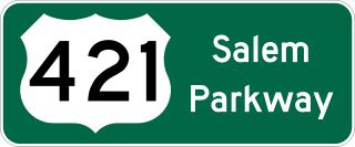
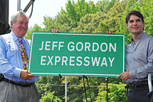
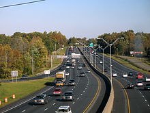
The Salem Parkway is an 18.5-mile-long (29.8 km) freeway in the U.S. state of North Carolina, serving the city of Winston-Salem and the town of Kernersville. It is signed as U.S. Route 421 (US 421) for its entire length, though it is also concurrent with US 158 in downtown Winston-Salem and North Carolina Highway 150 (NC 150) between Winston-Salem and Kernersville. Originally known as the East–West Expressway, it was designated as part of Interstate 40 (I-40) and opened in 1958, becoming the first section of Interstate Highway in the state. I-40 was rerouted onto a new alignment bypassing Winston-Salem and Kernersville in 1992, at which time the road was designated Interstate 40 Business, nicknamed Business 40.

<span class="mw-page-title-main">North Carolina Highway 67</span> State highway in North Carolina, US

North Carolina Highway 67 (NC 67) is a 40.9-mile-long (65.8 km) primary state highway in the U.S. state of North Carolina. The highway travels through Yadkin and Forsyth Counties between its western terminus at U.S. Route 21 Business in Jonesville and NC 150 in Winston-Salem. NC 67 primarily follows an east–west alignment and connects the towns of Jonesville, Boonville, and East Bend, along with the city of Winston-Salem.

<span class="mw-page-title-main">Charlotte Route 4</span>

Route 4 is an 18.6-mile (29.9 km) partial ring road located in Charlotte, North Carolina. Beginning and ending at Interstate 85 (I-85), it loops south around Uptown Charlotte along state-maintained secondary roads, connecting the Charlotte Douglas International Airport and several city neighborhoods including Madison Park, Myers Park, Windsor Park and Sugar Creek. The route is posted by the Charlotte Department of Transportation (CDOT), using a modified pentagonal county road shield, with a green background and the city's crown logo above the number. The loop has a radius of about 4 miles (6.4 km), hence the number.

<span class="mw-page-title-main">North Carolina Highway 150</span> State highway in North Carolina, US

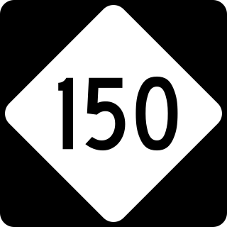
North Carolina Highway 150 (NC 150) is a primary state highway in the U.S. state of North Carolina. It serves the Foothills and Piedmont Triad areas of the state, connecting the cities of Shelby, Mooresville, Salisbury and Winston-Salem.

<span class="mw-page-title-main">Interstate 95 in North Carolina</span> Highway in North Carolina, US

Interstate 95 (I-95) is a part of the Interstate Highway System that runs along the East Coast of the United States from Miami, Florida, to the Canada–United States border at Houlton, Maine. In the state of North Carolina, the route runs for 181.36 miles (291.87 km) from the South Carolina border near Rowland to the Virginia border near Pleasant Hill. The highway serves the cities of Lumberton, Fayetteville, Wilson, Rocky Mount, and Roanoke Rapids. The route goes through a mostly rural area of the state, avoiding most of the major metro areas of North Carolina. It forms the informal border between the Piedmont and Atlantic Plain regions of the state.

<span class="mw-page-title-main">Interstate 74 in North Carolina</span> Highway in North Carolina

Interstate 74 (I-74) is a partially completed part of the Interstate Highway System that is planned to run from Davenport, Iowa, to Myrtle Beach, South Carolina. In the US state of North Carolina, I-74 currently exists in three distinct segments; from I-77 at the Virginia state line to US Highway 52 (US 52) near Mount Airy, from I-40 in Winston-Salem to US 220 near Ellerbe, and from US 74 and US 74 Business near Maxton to US 74/North Carolina Highway 41 (NC 41) near Lumberton. I-74 has an extensive concurrency with I-73 from Randleman to Ellerbe in the Piedmont. When completed, I-74 will link the cities of Mount Airy, Winston-Salem, High Point, Rockingham, Laurinburg, and Lumberton.

<span class="mw-page-title-main">Interstate 40 in North Carolina</span> Highway with its western terminus at the Tennessee state line

Interstate 40 (I-40) is a part of the Interstate Highway System that travels 2,556.61 miles (4,114.46 km) from Barstow, California, to Wilmington, North Carolina. In North Carolina, I-40 travels 420.21 miles (676.26 km) across the entirety of the state from the Tennessee state line along the Pigeon River Gorge to U.S. Highway 117 (US 117) and North Carolina Highway 132 (NC 132) in Wilmington. I-40 is the longest Interstate Highway in North Carolina and is the only Interstate to completely span the state from west to east.

<span class="mw-page-title-main">Interstate 77 in North Carolina</span> Highway in North Carolina

Interstate 77 (I-77) is a part of the Interstate Highway System that runs from Columbia, South Carolina, to Cleveland, Ohio. In North Carolina, I-77 enters the state at Charlotte, from South Carolina. Crossing the Piedmont, it connects with Statesville before continuing north into Virginia. The landscapes traversed by I-77 is a contrast of urban and rural foothills, with views of the Blue Ridge Mountains seen from a distance on its most northern section. The Interstate extends for 105.7 miles (170.1 km) and has one auxiliary route.

<span class="mw-page-title-main">Interstate 73 in North Carolina</span> Highway in North Carolina

Interstate 73 (I-73) is a partially completed Interstate Highway in the US state of North Carolina, traversing the state from south of Ellerbe to near Summerfield through Asheboro and Greensboro. When completed, it will continue south toward Myrtle Beach, South Carolina, and north to Price, North Carolina at the Virginia-North Carolina border.

<span class="mw-page-title-main">North Carolina Highway 268</span> State highway in North Carolina, US

North Carolina Highway 268 (NC 268) is a primary state highway in the U.S. state of North Carolina. It connects many communities as it traverses through the northwestern North Carolina mountains and foothills.

<span class="mw-page-title-main">U.S. Route 70 in North Carolina</span> Highway in North Carolina

U.S. Route 70 (US 70) is a part of the United States Numbered Highway System that runs from Globe, Arizona, to the Crystal Coast of the US state of North Carolina. In North Carolina, it is a major 488-mile-long (785 km) east–west highway that runs from the Tennessee border to the Atlantic Ocean. From the Tennessee state line near Paint Rock to Asheville it follows the historic Dixie Highway, running concurrently with US 25. The highway connects several major cities including Asheville, High Point, Greensboro, Durham, Raleigh, Goldsboro, and New Bern. From Beaufort on east, US 70 shares part of the Outer Banks Scenic Byway, a National Scenic Byway, before ending in the community of Atlantic, located along Core Sound.

<span class="mw-page-title-main">U.S. Route 421 in North Carolina</span> Highway in North Carolina

U.S. Route 421 (US 421) is part of the United States Numbered Highway System that runs from Fort Fisher, North Carolina to Michigan City, Indiana. In the U.S. state of North Carolina, US 421 travels 328 miles (528 km) from its southern terminus at Fort Fisher to the Tennessee state line near the community of Zionville, North Carolina. US 421 traverses the state from east to west travelling from the coastal plains to Appalachian Mountains. It provides an important connection between the cities of Wilmington, Sanford, Greensboro, Winston-Salem, and Boone. Despite being signed as north–south, much of the routing of US 421 in North Carolina runs in an east–west direction, particularly between Greensboro and the Tennessee state line. Portions of US 421 have been upgraded to freeway standards including the majority of its routing between Sanford and North Wilkesboro.

<span class="mw-page-title-main">U.S. Route 29 in North Carolina</span> Highway in North Carolina

U.S. Highway 29 (US 29) is a United States Numbered Highway that runs for 168.7 miles (271.5 km) from the South Carolina state line, near Blacksburg, to the commonwealth of Virginia, near Danville. It is signed with north–south cardinal directions but is actually a northeast and southwest diagonal highway throughout the state. The route serves the North Carolina Piedmont, including the cities of Charlotte, Salisbury, High Point, and Greensboro. From Salisbury to Greensboro, US 29 spends roughly a third of its length in the state being concurrent with US 70.

<span class="mw-page-title-main">U.S. Route 52 in North Carolina</span> Section of U.S. Highway in North Carolina, United States

U.S. Route 52 (US 52) is a north–south United States highway that runs for 150 miles (240 km) from the South Carolina state line, near McFarlan, to the Virginia state line, near Mount Airy. It serves as a strategic highway through the central North Carolina Piedmont. Because of its alignment in the state, US 52 does not follow the standard convention of an even U.S. route number going east–west.

<span class="mw-page-title-main">Interstate 87 (North Carolina)</span> Interstate Highway in Wake County, North Carolina, United States

Interstate 87 (I-87) is a partially completed Interstate Highway in the US state of North Carolina, the shortest designated primary Interstate Highway at 12.90 miles (20.76 km). The completed portion is in eastern Wake County, between Raleigh and Wendell; the majority of the completed route is known as the Knightdale Bypass, while the remaining three miles (4.8 km) follows the Raleigh Beltline (I-440). It is planned to continue northeast through Rocky Mount, Williamston, and Elizabeth City, ending in Norfolk, Virginia. It is signed as north–south, in keeping with the sign convention for most odd-numbered interstates, but the route goes primarily east–west, with the eastern direction aligning to the north designation. The entire route is concurrent with US Highway 64 (US 64), with portions also concurrent with I-440 and US 264.

<span class="mw-page-title-main">Interstate 885</span> Highway in North Carolina

Interstate 885 (I-885) and North Carolina Highway 885 (NC 885) is an 11.5-mile (18.5 km) auxiliary Interstate Highway and state highway in the U.S. state of North Carolina. It links NC 540 and I-40 to I-85 in the Durham area. The route consists of two previously preexisting segments of freeway—NC 147 to the south and US 70 to the north—connected by the East End Connector, which opened to traffic on June 30, 2022.

References

  1. Starks, Edward (January 27, 2022). "Table 1: Main Routes of the Dwight D. Eisenhower National System Of Interstate and Defense Highways". FHWA Route Log and Finder List. Federal Highway Administration . Retrieved August 21, 2022.
  2. North Carolina Department of Transportation (May 12, 2024). "Blue Star Memorial Highways Fact Sheet, 2019" (PDF). North Carolina Department of Transportation. Retrieved May 12, 2024.
  3. "Applying the Principles of the Work Zone Rule to Design-Build Projects, Two Case Studies: North Carolina I-85 Corridor Improvement Project". FHWA Work Zone. Federal Highway Administration. Retrieved April 3, 2024.
  4. North Carolina Department of Transportation (May 10, 2024). "Transportation Planning Branch" (PDF). North Carolina Department of Transportation. Retrieved May 10, 2024.
  5. Federal Highway Administration (March 25, 2015). National Highway System: North Carolina (PDF) (Map). Raleigh: Federal Highway Administration. Archived (PDF) from the original on September 22, 2015. Retrieved April 6, 2016.
  6. "What is the National Highway System?". National Highway System. Federal Highway Administration. February 26, 2016. Archived from the original on September 24, 2012. Retrieved April 6, 2016.
  7. North Carolina Department of Transportation (May 9, 2024). "Cleveland County" (PDF). North Carolina Department of Transportation. Retrieved May 9, 2024.
  8. Nelson, Omar (December 14, 2017). "I-85/US 321 interchange construction underway in Gastonia". City News Source. Retrieved April 4, 2024.
  9. North Carolina Department of Transportation (May 10, 2024). "NC 7 Interchange - Gaston County" (PDF). North Carolina Department of Transportation. Retrieved May 10, 2024.
  10. Naples Daily. "I85 over CATAWBA RIVER Gaston County, North Carolina Bridge Inspection Report". Naples Daily News. Retrieved May 10, 2024.
  11. "NCDOT: I-85/I-485 Interchange Improvements, West of Charlotte". North Carolina Department of Transportation. Retrieved April 4, 2024.
  12. "NCDOT: I-85 Widening - Gaston County". North Carolina Department of Transportation. Retrieved April 4, 2024.
  13. North Carolina Department of Transportation (May 10, 2024). "Mecklenburg County" (PDF). North Carolina Department of Transportation. Retrieved May 10, 2024.
  14. Thompson, Jen (July–August 2013). "North Carolina Steps Boldly Out of Its Comfort Zone". Public Roads. Vol. 77, no. 1. Federal Highway Administration. FHWA-HRT-13-005. Retrieved April 3, 2024.
  15. "New I-85 flyover bridge will connect I-85 to Concord Mills". WSOC-TV. January 9, 2018. Retrieved May 10, 2024.
  16. "I-85 over CODDLE CREEK Cabarrus County, North Carolina Bridge Inspection Report" . Retrieved May 10, 2024 via USA Today.
  17. Kannapolis, NC (May 9, 2024). NCRC Campus Map 2021 (PDF) (Map). Kannapolis, North Carolina. Retrieved May 9, 2024.
  18. "Project Spotlight: I-85 Yadkin River Bridge" (PDF). North Carolina Department of Transportation. n.d. Retrieved April 3, 2024.
  19. North Carolina Department of Transportation (October 2018). Davidson County, North Carolina (PDF) (Map). Raleigh: North Carolina Department of Transportation. Enlarged Municipal and Suburban Areas inset. Retrieved April 3, 2024.
  20. Google (May 2023). "I-85, Lexington, North Carolina". Google Street View . Google. Retrieved March 30, 2024.
  21. Google (November 2022). "I-85, Thomasville, North Carolina". Google Street View . Google. Retrieved March 30, 2024.
  22. "Greensboro Urban Loop comes full circle as city sets Monday as opening day for final stretch". FOX8. WGHP-TV. January 20, 2023. Retrieved March 30, 2024.
  23. North Carolina Department of Transportation (September 2018). Guilford County, North Carolina (PDF) (Map). Raleigh: North Carolina Department of Transportation. Sheet 8 of 10. Enlarged Municipal and Suburban Areas inset. Retrieved April 3, 2024.
  24. "NCDOT: Greensboro Urban Loop". North Carolina Department of Transportation. Retrieved May 10, 2024.
  25. Google (October 2014). "I-85, Burlington, NC". Google Street View . Google. Retrieved May 9, 2024.
  26. North Carolina State Tax Commission (2013). State Transportation Map (Map) (2013–2014 ed.). North Carolina Department of Transportation.
  27. North Carolina Department of Transportation (May 9, 2024). "Durham County" (PDF). North Carolina Department of Transportation. Retrieved May 9, 2024.
  28. "Projects Overview". gis.dchcmpo.org. Retrieved March 30, 2024.
  29. "Falls Lake at Interstate 85 Near Redwood, NC". waterdata.usgs.gov. Retrieved May 10, 2024.
  30. North Carolina Department of Transportation (May 9, 2024). Granville County Bridge (PDF) (Map). North Carolina Department of Transportation. Retrieved May 9, 2024.
  31. North Carolina Department of Transportation (May 9, 2024). Vance County (PDF) (Map). North Carolina Department of Transportation. Retrieved May 9, 2024.
  32. Google (June 2011). "I-85, Norlina, North Carolina". Google Street View . Google. Retrieved May 9, 2024.
  33. Sun, Kitsap. "SBL ROUTE I-85 over ROANOKE RIVER Mecklenburg County, Virginia Bridge Inspection Report". Kitsap Sun. Retrieved May 10, 2024.
  34. "NCDOT: NC Blue Star Memorial Marker Locations". North Carolina Department of Transportation. Archived from the original on May 22, 2011. Retrieved June 19, 2011.
  35. 1 2 3 4 5 "North Carolina Memorial Highways and other Named Facilities" (PDF). North Carolina Department of Transportation. Archived from the original (PDF) on May 19, 2011. Retrieved June 19, 2011.
  36. Crump, Steve (May 25, 2018). "A highway honor for a civil rights hero". Charlotte, North Carolina: WBTV . Retrieved June 1, 2018.
  37. Lowe, Jonathan (May 24, 2018). "Part of I-85 named after prominent attorney, civil rights activist". Charlotte, North Carolina: Spectrum News . Retrieved June 1, 2018.
  38. Busbee, Jay (May 26, 2013). "There is, alas, a speed limit on the Jeff Gordon Expressway". Yahoo! Sports . Retrieved September 2, 2013.
  39. Flores, Adrianne; Brad Broders (October 19, 2011). "Mecklenburg County Commissioners approve 'Jeff Gordon Expressway'". Raleigh, North Carolina: News 14 Carolina. Archived from the original on October 25, 2011. Retrieved October 19, 2011.
  40. Lyttle, Steve (May 24, 2012). "Ready for the Jeff Gordon Expressway?". Sun Herald . Gulfport, Misssisssippi. Retrieved June 19, 2012.[ permanent dead link ]
  41. "Flickr - I-85 Jeff Gordon Expressway Ceremony". May 25, 2012. Retrieved June 19, 2012 via Flickr.
  42. "NCDOT dedicates section of I-85 in Mecklenburg County as the Jeff Gordon Expressway". Hendrick Motorsports. May 25, 2012. Retrieved October 6, 2015.
  43. "Bill to rename Yadkin River Bridge passes". Salisbury Post. May 13, 2011. Archived from the original on March 15, 2012. Retrieved May 6, 2012.
  44. 1 2 Stratton, Seth (December 16, 2008). "DOT dedicates part of I-85 as Childress freeway". The-Dispatch.com. Archived from the original on June 23, 2015. Retrieved June 22, 2015.
  45. "State names part of I-85 in Guilford County for late Rep. Howard Coble". News & Record . Greensboro, North Carolina. December 1, 2016. Retrieved December 6, 2016.
  46. Baumgartner Vaughan, Dawn (November 27, 2017). "Why I-85 in Durham is now the 'Dr. John H. Franklin Highway'". News & Observer . Raleigh, North Carolina. Retrieved November 28, 2017.
  47. "NCDOT: Section of I-85 near Henderson Renamed Andrea L Harris Highway". Henderson, North Carolina: WIZS-AM. December 15, 2023. Retrieved May 9, 2024.
  48. 1 2 3 North Carolina Department of Transportation. "Facts: Interstate 85" (PDF). North Carolina Department of Transportation. p. 1. Archived from the original (PDF) on February 3, 2007. Retrieved April 21, 2007.
  49. "This day in history". News and Record . January 9, 2016. Retrieved November 9, 2016.
  50. 1 2 3 4 Johnston, Louis; Williamson, Samuel H. (2023). "What Was the U.S. GDP Then?". MeasuringWorth . Retrieved November 30, 2023. United States Gross Domestic Product deflator figures follow the MeasuringWorth series.
  51. 1 2 3 4 Turner, Walter R. (August 5, 2012). "The mysterious Yadkin River bridge". Salisbury Post . Archived from the original on August 6, 2012. Retrieved August 7, 2012.
  52. North Carolina Department of Transportation. "Facts: Interstate 85" (PDF). North Carolina Department of Transportation. p. 2. Archived from the original (PDF) on February 3, 2007. Retrieved April 21, 2007.
  53. "I-85 Traffic Flow May Be Smoother". The Charlotte Observer . Associated Press. December 16, 1988. p. 5B.
  54. "North Carolina - Wider I-85 Recommended". The Charlotte Observer . January 27, 1989. p. 2B.
  55. Hall, David A. (November 23, 1994). "Interstate 40/85 Freeway Isn't Free of Construction". Greensboro News & Record . p. A1.
  56. Hammer, John (January 20, 2023). "After 56 Years The Urban Loop Officially Opens Monday, Jan. 23". The Rhino Times of Greensboro. Retrieved March 30, 2024.
  57. 1 2 3 "NCDOT: I-85 Corridor Improvement Project". Archived from the original on July 8, 2011. Retrieved June 19, 2011.
  58. "NCDOT to open new I-85 Yadkin River bridge on Friday". Charlotte, North Carolina: WBTV-TV. April 6, 2013. Retrieved April 17, 2014.
  59. "The I-85 Yadkin River Bridge, Salisbury, North Carolina". Archived from the original on April 19, 2014. Retrieved April 17, 2014.
  60. Lyttle, Steve (April 3, 2012). "Part of widened I-85 to open this weekend". Charlotte Observer . Retrieved April 17, 2014.
  61. "NCDOT: I-85 Widening and Improvements". Archived from the original on March 29, 2017. Retrieved March 28, 2017.
  62. Lyttle, Steve (April 12, 2012). "DOT awards contract for I-85 widening in Cabarrus County". Charlotte Observer . Retrieved April 14, 2014.
  63. Google (December 27, 2012). "Interstate 85" (Map). Google Maps . Google. Retrieved December 27, 2012.
  64. "2023-2024 North Carolina State Transportation Map" (PDF). North Carolina Department of Transportation Mapping Section. Retrieved April 10, 2024.
  65. Turbyfill, Diane (August 5, 2022). "Crews to make improvements to I-85 at night". Grover, NC: The Shelby Star . Retrieved April 4, 2024.
  66. Lyttle, Steve (September 8, 2014). "Diverging diamond opens on Poplar Tent Road". Charlotte Observer . Retrieved September 8, 2014.
  67. Marusak, Joe (February 4, 2012). "New interchange planned for bottlenecked I-77 exit". Charlotte Observer. Archived from the original on June 1, 2012. Retrieved March 2, 2013.
  68. "I-85 Exit 65 Opens". Kannapolis, NC: City of Kannapolis. November 14, 2019. Retrieved April 5, 2024.
  69. "Safety concerns lead to closing of Wil-Cox Bridge; no timeframe on reopening". SalisburyPost.com. Archived from the original on July 15, 2011. Retrieved February 18, 2011.
  70. 1 2 "NC 150 Route Change (2012-03-01)" (PDF). North Carolina Department of Transportation. March 1, 2012. Retrieved May 26, 2013.
  71. 1 2 "NC 150 Route Change (2012-01-04)" (PDF). North Carolina Department of Transportation. January 4, 2012. Retrieved May 26, 2013.
  72. Staff (July 27, 2011). "NCDOT to close Clark Road entrance and exits ramps on I-85 north, section of Snider Kines Road in Davidson County starting Monday". Project Details. North Carolina Department of Transportation. Archived from the original on April 19, 2014. Retrieved December 26, 2012.
  73. "NCDOT: I-285 Gets Federal Approval as the Next New Interstate for North Carolina". NCDOT. Retrieved May 9, 2024.
  74. Goodpasture, Joe (August 19, 2008). "First portion of I-485 Opens". Charlotte Magazine. Retrieved May 9, 2024.
  75. "FHWA - Center for Innovative Finance Support - Project Profiles". www.fhwa.dot.gov. Retrieved May 9, 2024.
  76. Saunders, Tim (September 10, 2019). "Funding committed for long-awaited I-785, slated to reach Danville". WBDJ. Retrieved May 10, 2024.
  77. North Carolina Department of Transportation (May 9, 2024). "Proposed Interchange Numbering and Alignments for Routes I-885, Toll NC-885, and NC-147" (PDF). North Carolina Department of Transportation. Retrieved May 9, 2024.
  78. North Carolina Department of Transportation (July 2019). "High Point Urban Area MPO:Removal of "Business 85"". North Carolina Department of Transportation. Retrieved May 9, 2024.
Template:Attached KML/Interstate 85 in North Carolina
KML is from Wikidata
I-85.svg Interstate 85
Previous state:
South Carolina
North Carolina Next state:
Virginia