East Spencer, North Carolina

Last updated

East Spencer, North Carolina
East Spencer Seal.jpg
NCMap-doton-EastSpencer.PNG
Location of East Spencer, North Carolina
Coordinates: 35°40′54″N80°25′22″W / 35.68167°N 80.42278°W / 35.68167; -80.42278
Country United States
State North Carolina
County Rowan
Area
[1]
  Total2.11 sq mi (5.46 km2)
  Land2.11 sq mi (5.46 km2)
  Water0.00 sq mi (0.00 km2)
Elevation
[2]
696 ft (212 m)
Population
 (2020)
  Total1,567
  Density743.36/sq mi (287.08/km2)
Time zone UTC-5 (Eastern (EST))
  Summer (DST) UTC-4 (EDT)
ZIP code
28039
Area code 704
FIPS code 37-19860 [3]
GNIS feature ID2406415 [2]

East Spencer is a town in Rowan County, North Carolina, United States. The population was 1,534 at the 2010 census. Originally called "Southern City" because of significance of the railway to the area, it was incorporated in 1901 as East Spencer. It was named for the Spencer shops that opened in the area in 1896. [4]

Contents

Geography

East Spencer is located adjacent to and south of the town of Spencer, North Carolina. The Southern Railway tracks separate the two towns. [5]

According to the United States Census Bureau, the town has a total area of 1.6 square miles (4.1 km2), all land.

Government

The town of East Spencer is governed by a mayor and six board of alderman members. The mayor serves a two-year term and the board members serve staggered four-year terms. The board of alderman selects a town manager, who conducts the business of the Town, supervise staff, manages finances, prepares meetings and assists the town as needed. [6]

A post office was first established in East Spencer on February 12, 1919, with William J. Hatley as postmaster. [7]

Demographics

Historical population
CensusPop.Note
1910 1,729
1920 2,23929.5%
1930 2,098−6.3%
1940 2,1814.0%
1950 2,44412.1%
1960 2,171−11.2%
1970 2,2172.1%
1980 2,150−3.0%
1990 2,055−4.4%
2000 1,755−14.6%
2010 1,534−12.6%
2020 1,5672.2%
U.S. Decennial Census [8]

2020 census

East Spencer racial composition [9]
RaceNumberPercentage
White (non-Hispanic)23314.87%
Black or African American (non-Hispanic)1,07868.79%
Native American 60.38%
Asian 70.45%
Pacific Islander 40.26%
Other/Mixed 865.49%
Hispanic or Latino 1539.76%

As of the 2020 United States census, there were 1,567 people, 527 households, and 287 families residing in the town.

2000 census

As of the census [3] of 2000, there were 1,755 people, 697 households, and 450 families residing in the town. The population density was 1,115.3 inhabitants per square mile (430.6/km2). There were 796 housing units at an average density of 505.8 per square mile (195.3/km2). The racial makeup of the town was 11.79% White, 85.81% African American, 0.17% Native American, 0.06% Asian, 0.06% Pacific Islander, 0.91% from other races, and 1.20% from two or more races. Hispanic or Latino of any race were 2.74% of the population.

There were 697 households, out of which 35.2% had children under the age of 18 living with them, 25.1% were married couples living together, 34.1% had a female householder with no husband present, and 35.4% were non-families. 32.1% of all households were made up of individuals, and 12.8% had someone living alone who was 65 years of age or older. The average household size was 2.52 and the average family size was 3.18.

In the town, the population was spread out, with 33.8% under the age of 18, 8.7% from 18 to 24, 25.5% from 25 to 44, 20.2% from 45 to 64, and 11.7% who were 65 years of age or older. The median age was 30 years. For every 100 females, there were 80.0 males. For every 100 females age 18 and over, there were 73.8 males.

The median income for a household in the town was $18,947, and the median income for a family was $22,222. Males had a median income of $23,203 versus $21,801 for females. The per capita income for the town was $10,180. About 32.2% of families and 35.8% of the population were below the poverty line, including 47.4% of those under age 18 and 27.5% of those age 65 or over.

Schools

Churches

The following religious organizations are located in East Spencer: [13]

Notable people

Related Research Articles

<span class="mw-page-title-main">Kannapolis, North Carolina</span> City in North Carolina, United States

Kannapolis is a city in Cabarrus and Rowan counties, in the U.S. state of North Carolina, northwest of Concord and northeast of Charlotte and is a suburb in the Charlotte metropolitan area. The city of Kannapolis was incorporated in 1984. The population was 53,114 at the 2020 census, which makes Kannapolis the 19th-most populous city in North Carolina. It is the home of the Kannapolis Cannon Ballers, the Low-A baseball affiliate of the Chicago White Sox, and it is the hometown of the Earnhardt racing family. It is also the headquarters for the Haas F1 racing team. The center of the city is home to the North Carolina Research Campus, a public-private venture that focuses on food, nutrition, and biotech research.

<span class="mw-page-title-main">Camden County, North Carolina</span> Consolidated city-county in North Carolina, United States

Camden County is a consolidated city-county located in the U.S. state of North Carolina. As of the 2020 census, the population was 10,355, making it the fourth-least populous county in North Carolina. Its county seat is Camden. Camden County is included in the Virginia Beach-Chesapeake, VA-NC Combined Statistical Area.

<span class="mw-page-title-main">Mount Lebanon, Louisiana</span> Town in Louisiana, United States

Mount Lebanon is a town in Bienville Parish, Louisiana, United States. The population was 83 at the 2010 census.

<span class="mw-page-title-main">Ringgold, Louisiana</span> Town in Louisiana, United States

Ringgold is a town in the U.S. state of Louisiana, in the western half of Bienville Parish. The town of Ringgold is named for United States Army Major Samuel Ringgold. The population of Ringgold was 1,495 at the 2010 census, and 1,370 at the U.S. Census Bureau's 2019 estimates, down from 1,601 in 2018. The 2020 U.S. census estimates program recorded a population of 1,336, though the census established a population of 1,379. It is the second largest incorporated municipality in Bienville Parish by population.

<span class="mw-page-title-main">Montgomery, Louisiana</span> Town in Louisiana, United States

Montgomery is a town in the far northwestern portion of Grant Parish, which is located in north-central Louisiana, United States. The population of Montgomery was 726 at the 2010 census. The town has a poverty rate of 37 percent and a median household income of just under $22,000. The median age is just under forty; the population in 2010 was 78 percent white.

<span class="mw-page-title-main">Weaverville, North Carolina</span> Town in North Carolina, United States

Weaverville is a town in Buncombe County, North Carolina, United States. The population was 4,567 at the 2020 census. It is part of the Asheville metropolitan area.

<span class="mw-page-title-main">Valdese, North Carolina</span> Town in North Carolina, United States

Valdese is a town in Burke County, North Carolina, United States. The population was 4,689 at the 2020 census. It is part of the Hickory-Lenoir-Morganton Metropolitan Statistical Area. One of the largest Waldensian congregations in the United States was founded in the town in the late nineteenth century, now known as the Waldensian Presbyterian Church. The town was settled by immigrants from the Cottian Alps in the Piedmont region of Italy.

<span class="mw-page-title-main">Boiling Springs, North Carolina</span> Town in North Carolina, United States

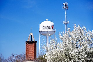
Boiling Springs is a town in Cleveland County, North Carolina, United States and is located in the westernmost part of the Charlotte metropolitan area, located approximately 50 miles away from the city. As of the 2010 census, the town's population was 4,647. It is home to Gardner–Webb University. The town is named after the natural spring found on the university's property, which feeds a small lake.

<span class="mw-page-title-main">High Shoals, North Carolina</span> City in North Carolina, United States

High Shoals is a city in Gaston County, North Carolina, United States, named for the high rocky shoal across the Catawba River. The population was 696 at the 2010 census.

<span class="mw-page-title-main">Stanley, North Carolina</span> Town in North Carolina, United States

Stanley is a town in Gaston County, North Carolina, United States. The population was 3,556 at the 2010 census.

<span class="mw-page-title-main">Summerfield, North Carolina</span> Town in North Carolina, United States

Summerfield is a town in Guilford County, North Carolina. As of the 2020 census, the population was 10,951.

<span class="mw-page-title-main">Ahoskie, North Carolina</span> Town in North Carolina, United States

Ahoskie is a town in Hertford County, North Carolina, United States. The population was 5,039 at the 2010 census. Ahoskie is located in North Carolina's Inner Banks region. Its nickname is "The Only One" because no other town in the world is known by the same name. The etymology of the word Ahoskie, which was originally spelled "Ahotsky", was from the Wyanoke Indians, who entered the Hertford County area at the beginning of European settlement.

<span class="mw-page-title-main">Webster, North Carolina</span> Town in North Carolina, United States

Webster is a town in Jackson County, North Carolina, United States. As of the 2010 census, the population was 363, down from 486 in 2000.

<span class="mw-page-title-main">Mars Hill, North Carolina</span> Town in North Carolina, United States

Mars Hill is a town in Madison County, North Carolina, United States. The population was 1,869 at the 2010 census, and was estimated at 2,032 in 2018 by the U.S. Census. It is the home of Mars Hill University, the name of which was inspired by Acts 17:22. The town is located 15 miles (24 km) due north of Asheville. Interstate 26 passes one mile east of the town. It is part of the Asheville Metropolitan Statistical Area.

<span class="mw-page-title-main">China Grove, North Carolina</span> Town in North Carolina, United States

China Grove is a town in Rowan County, North Carolina, United States. The population was 4,434 at the 2020 census. The town is located just north of Landis and south of Salisbury. It was one of the first towns in the United States to have Rural Free Mail Delivery.

<span class="mw-page-title-main">Enochville, North Carolina</span> CDP in North Carolina, United States

Enochville is a census-designated place (CDP) in Rowan County, North Carolina, United States. The population was 2,851 at the 2000 census.

<span class="mw-page-title-main">Granite Quarry, North Carolina</span> Town in North Carolina, United States

Granite Quarry is a town in Rowan County, North Carolina, United States. The population was 2,984 at the 2020 census.

<span class="mw-page-title-main">Rockwell, North Carolina</span> Town in North Carolina, United States

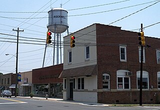
Rockwell is a town in Rowan County, North Carolina, United States. The population was 2,302 at the 2020 census.

<span class="mw-page-title-main">Salisbury, North Carolina</span> City in North Carolina, United States

Salisbury is a city in the Piedmont region of North Carolina, United States; it has been the county seat of Rowan County since 1753 when its territory extended to the Mississippi River. Located 25 miles (40 km) northeast of Charlotte and within its metropolitan area, the town has attracted a growing population. The 2020 census shows 35,580 residents.

<span class="mw-page-title-main">Spencer, North Carolina</span> Town in North Carolina, United States

Spencer is a town in Rowan County, North Carolina, United States, incorporated in 1905. As of the 2010 census, the town population was 3,267.

References

  1. "ArcGIS REST Services Directory". United States Census Bureau. Retrieved September 20, 2022.
  2. 1 2 U.S. Geological Survey Geographic Names Information System: East Spencer, North Carolina
  3. 1 2 "U.S. Census website". United States Census Bureau . Retrieved January 31, 2008.
  4. "Rowan Economic Development Councile, East Spencer" . Retrieved February 20, 2019.
  5. "US Gazetteer files: 2010, 2000, and 1990". United States Census Bureau. February 12, 2011. Retrieved April 23, 2011.
  6. "East Spencer Mayor and Town Board" . Retrieved February 20, 2019.
  7. Lewis, J.D. "North Carolina Post Offices" . Retrieved February 20, 2019.
  8. "Census of Population and Housing". Census.gov. Retrieved June 4, 2015.
  9. "Explore Census Data". data.census.gov. Retrieved December 21, 2021.
  10. Bergeron, Josh (January 1, 2015). "Dunbar Center's History Dates Back to 1900" . Retrieved February 20, 2019.
  11. "Essie Mae Kiser Foxx Charter School" . Retrieved February 20, 2019.
  12. Salisbury Post (May 26, 2017). "Essie Foxx, Obituary" . Retrieved February 20, 2019.
  13. Google Maps
  14. Bobby Jackson - The Draft Review Retrieved July 28, 2018.

See also