Rockwell, North Carolina

Last updated

Rockwell, North Carolina
Rockwell NC 1.jpg
NCMap-doton-Rockwell.PNG
Location of Rockwell, North Carolina
Coordinates: 35°33′11″N80°24′33″W / 35.55306°N 80.40917°W / 35.55306; -80.40917
Country United States
State North Carolina
County Rowan
Area
[1]
  Total1.85 sq mi (4.79 km2)
  Land1.85 sq mi (4.79 km2)
  Water0.00 sq mi (0.00 km2)
Elevation
[2]
781 ft (238 m)
Population
 (2020)
  Total2,302
  Density1,245.67/sq mi (480.94/km2)
Time zone UTC-5 (Eastern (EST))
  Summer (DST) UTC-4 (EDT)
ZIP code
28138
Area code 704
FIPS code 37-57340 [3]
GNIS feature ID2407232 [2]

Rockwell is a town in Rowan County, North Carolina, United States. The population was 2,302 at the 2020 census.

Contents

History

The George Matthias Bernhardt House, Grace Evangelical and Reformed Church, and Zion Lutheran Church are listed on the National Register of Historic Places. [4]

Geography

According to the United States Census Bureau, the town has a total area of 1.7 square miles (4.4 km2), all land.

Demographics

Historical population
CensusPop.Note
1910 249
1920 45381.9%
1930 69653.6%
1940 82518.5%
1950 8523.3%
1960 94811.3%
1970 9995.4%
1980 1,33934.0%
1990 1,59819.3%
2000 1,97123.3%
2010 2,1087.0%
2020 2,3029.2%
U.S. Decennial Census [5]

2020 census

Rockwell racial composition [6]
RaceNumberPercentage
White (non-Hispanic)1,97085.58%
Black or African American (non-Hispanic)853.69%
Native American 50.22%
Asian 180.78%
Pacific Islander 20.09%
Other/Mixed 1124.87%
Hispanic or Latino 1104.78%

As of the 2020 United States census, there were 2,302 people, 769 households, and 556 families residing in the town.

2000 census

As of the census [3] of 2000, there were 1,971 people, 744 households, and 552 families residing in the town. The population density was 1,183.8 inhabitants per square mile (457.1/km2). There were 781 housing units at an average density of 469.1 per square mile (181.1/km2). The racial makeup of the town was 97.21% White, 0.71% African American, 0.05% Native American, 0.56% Asian, 0.76% from other races, and 0.71% from two or more races. Hispanic or Latino of any race were 1.57% of the population.

There were 744 households, out of which 35.5% had children under the age of 18 living with them, 59.8% were married couples living together, 10.5% had a female householder with no husband present, and 25.7% were non-families. 23.3% of all households were made up of individuals, and 11.8% had someone living alone who was 65 years of age or older. The average household size was 2.52 and the average family size was 2.96.

In the town, the population was spread out, with 25.6% under the age of 18, 7.7% from 18 to 24, 28.4% from 25 to 44, 20.6% from 45 to 64, and 17.7% who were 65 years of age or older. The median age was 38 years. For every 100 females, there were 87.9 males. For every 100 females age 18 and over, there were 83.8 males.

The median income for a household in the town was $41,488, and the median income for a family was $47,935. Males had a median income of $31,763 versus $23,304 for females. The per capita income for the town was $19,687. About 3.6% of families and 4.6% of the population were below the poverty line, including 4.4% of those under age 18 and 9.1% of those age 65 or over.

Education

Rockwell Elementary School- Rockets- Rockwell Christian School- Shive Elementary School- Grace Academy

Rockwell Elementary School, formerly known as Rockwell School, was built in 1928. It combined a total of eighteen one and two room school houses within the eastern part of Rowan County. Until 1959, Rockwell School housed grades 1-12. Beginning in 1959, Rockwell housed grades 1–6. In 1973, Kindergarten was added and made Rockwell a K-6 school. In 1990, Rowan County changed all of the elementary schools to K-5 and this configuration is still in place today. [7]

Library

The East Branch of the Rowan Public Library (whose main facility is in Salisbury) is located in Rockwell.

Places of worship

Related Research Articles

<span class="mw-page-title-main">Lowell, Arkansas</span> City in Arkansas, United States

Lowell is a city in Benton County, Arkansas, United States. Located within the Ozarks, the first settlement was along Old Wire Road in the 1840s, and although destroyed during the Civil War, the community was reestablished by J. R. McClure and thrived when the St. Louis–San Francisco Railway came through the area in the 1880s. The city is a growing bedroom community within the rapidly growing Northwest Arkansas region. Lowell is the headquarters of trucking company J.B. Hunt. Lowell's population was 9,839 at the 2020 census, an increase of 34% since 2010.

<span class="mw-page-title-main">Mango, Florida</span> Census-designated place in Florida, United States

Mango is a census-designated place (CDP) in Hillsborough County, Florida, United States. The population was 12,699 at 2020 census, up from the 11,313 at the 2010 census.

<span class="mw-page-title-main">Saint Joe, Indiana</span> Place in Indiana, United States

Saint Joe is a town in Concord Township, DeKalb County, Indiana, United States. The population was 460 at the 2010 census.

<span class="mw-page-title-main">Rowan, Iowa</span> City in Iowa, United States

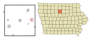
Rowan is a city in Wright County, Iowa, United States. The population was 123 at the time of the 2020 census.

<span class="mw-page-title-main">Storden, Minnesota</span> City in Minnesota, United States

Storden is a city in Cottonwood County, Minnesota, United States. The population was 219 at the 2010 census.

<span class="mw-page-title-main">Zumbrota, Minnesota</span> City in Minnesota, United States

Zumbrota is a city in Goodhue County, Minnesota, United States, along the North Fork of the Zumbro River. The population was 3,252 at the 2010 census. It promotes itself as "the only Zumbrota in the world."

<span class="mw-page-title-main">Grand Rapids, Minnesota</span> City in Minnesota, United States

Grand Rapids is a city in Itasca County, Minnesota, United States, and it is the county seat. The population was 11,126 at the 2020 census. The city is named for the 3.5-mile (5.6 km) long rapids in the Mississippi River which was the uppermost limit of practical steamboat travel during the late 19th century. Today the rapids are hidden below the dam of UPM Paper Company.

<span class="mw-page-title-main">North St. Paul, Minnesota</span> City in Minnesota, United States

North Saint Paul is a city in Ramsey County, Minnesota, United States, located east-northeast of the city of Saint Paul. The population was 12,364 at the 2020 census.

<span class="mw-page-title-main">Longtown, Missouri</span> Village in Missouri, United States

Longtown is a village in Union Township in Perry County, Missouri, United States. The population was 90 at the 2020 census.

<span class="mw-page-title-main">East Spencer, North Carolina</span> Town in North Carolina, United States

East Spencer is a town in Rowan County, North Carolina, United States. The population was 1,534 at the 2010 census. Originally called "Southern City" because of significance of the railway to the area, it was incorporated in 1901 as East Spencer. It was named for the Spencer shops that opened in the area in 1896.

<span class="mw-page-title-main">Granite Quarry, North Carolina</span> Town in North Carolina, United States

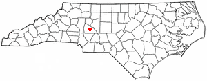
Granite Quarry is a town in Rowan County, North Carolina, United States. The population was 2,984 at the 2020 census.

<span class="mw-page-title-main">Turbotville, Pennsylvania</span> Borough in Pennsylvania, United States

Turbotville Borough is a borough in Northumberland County, Pennsylvania, United States. The population was 705 at the 2010 census.

<span class="mw-page-title-main">Klingerstown, Pennsylvania</span> CDP in Pennsylvania, United States

Klingerstown is a census-designated place (CDP) in Upper Mahantongo Township, Schuylkill County, Pennsylvania, United States. As of the 2000 census, the CDP population was 102.

<span class="mw-page-title-main">Ripley, Tennessee</span> City in Tennessee, United States

Ripley is a city in Lauderdale County, Tennessee, United States. The population was 8,445 at the 2010 census. It is the county seat of Lauderdale County.

<span class="mw-page-title-main">Elk Plain, Washington</span> CDP in Washington, United States

Elk Plain is a census-designated place (CDP) in Pierce County, Washington, United States. The population was 14,534 at the 2020 census.

<span class="mw-page-title-main">Zillah, Washington</span> City in Washington, United States

Zillah is a city in Yakima County, Washington, United States, with a population of 3,179 as of the 2020 census.

<span class="mw-page-title-main">DeForest, Wisconsin</span> Village in Wisconsin, United States

DeForest is a village in Dane County, Wisconsin, United States, along the Yahara River. The population was 10,811 at the 2020 census. It is part of the Madison Metropolitan Statistical Area.

<span class="mw-page-title-main">Lebanon, Dodge County, Wisconsin</span> Town in Wisconsin, United States

Lebanon is a town in Dodge County, Wisconsin, United States. The population was 1,664 at the 2000 census. The census-designated place of Lebanon is located in the town, as are the unincorporated communities of Old Lebanon and Sugar Island.

<span class="mw-page-title-main">Hartland, Wisconsin</span> Village in Wisconsin, United States

Hartland is a village along the Bark River in Waukesha County, Wisconsin, United States, that is a suburb of Milwaukee. The population was 9,501 at the 2020 census.

<span class="mw-page-title-main">Le Sueur, Minnesota</span> City in Minnesota, United States

Le Sueur is a city in Le Sueur County in the U.S. state of Minnesota, between Mankato and the Twin Cities. It lies along the Minnesota River and U.S. Highway 169. Le Sueur was named in honor of the French explorer Pierre-Charles Le Sueur. The population was 4,213 at the 2020 census.

References

  1. "ArcGIS REST Services Directory". United States Census Bureau. Retrieved September 20, 2022.
  2. 1 2 U.S. Geological Survey Geographic Names Information System: Rockwell, North Carolina
  3. 1 2 "U.S. Census website". United States Census Bureau . Retrieved January 31, 2008.
  4. "National Register Information System". National Register of Historic Places . National Park Service. July 9, 2010.
  5. "Census of Population and Housing". Census.gov. Retrieved June 4, 2015.
  6. "Explore Census Data". data.census.gov. Retrieved December 21, 2021.
  7. "Archived copy". Archived from the original on June 1, 2013. Retrieved October 6, 2013.{{cite web}}: CS1 maint: archived copy as title (link)
  8. New Haven Baptist Church Archived September 7, 2008, at the Wayback Machine