Faith, North Carolina

Last updated

Faith, North Carolina
NCMap-doton-Faith.PNG
Location of Faith, North Carolina
Coordinates: 35°35′24″N80°27′30″W / 35.59000°N 80.45833°W / 35.59000; -80.45833
Country United States
State North Carolina
County Rowan
Area
[1]
  Total1.05 sq mi (2.71 km2)
  Land1.05 sq mi (2.71 km2)
  Water0.00 sq mi (0.00 km2)
Elevation
[2]
886 ft (270 m)
Population
 (2020)
  Total819
  Density781.49/sq mi (301.74/km2)
Time zone UTC-5 (Eastern (EST))
  Summer (DST) UTC-4 (EDT)
ZIP code
28041
Area code 704
FIPS code 37-22600 [3]
GNIS feature ID2406483 [2]
Website www.faithnc.com

Faith is a town in Rowan County, North Carolina, United States, incorporated in 1903. The population was 807 at the 2010 census.

Contents

Since 1946, the town has hosted a Fourth of July celebration that has become notably large for a town of its population – running for several days and drawing visitors from many states. The Faith Fourth achieved national visibility in 1992, when President George H. W. Bush not only made a speech praising small town virtues, but also participated in the traditional Fourth of July softball game.

History

Shuping's Mill Complex was listed on the National Register of Historic Places in 1982. [4]

Historian and sociologist James W. Loewen has identified Faith as one of several possible sundown towns in North Carolina. [5]

Geography

According to the United States Census Bureau, the town has a total area of 1.0 square mile (2.6 km2), all land.

Demographics

Historical population
CensusPop.Note
1910 352
1920 348−1.1%
1930 43123.9%
1940 4494.2%
1950 4909.1%
1960 4940.8%
1970 5062.4%
1980 5529.1%
1990 5530.2%
2000 69525.7%
2010 80716.1%
2020 8191.5%
U.S. Decennial Census [6]

2020 census

Faith racial composition [7]
RaceNumberPercentage
White (non-Hispanic)74691.09%
Black or African American (non-Hispanic)20.24%
Native American 20.24%
Asian 40.49%
Other/Mixed 374.52%
Hispanic or Latino 283.42%

As of the 2020 United States census, there were 819 people, 309 households, and 222 families residing in the town.

2000 census

As of the census [3] of 2000, there were 695 people, 276 households, and 210 families residing in the town. The population density was 710.2 people per square mile (274.2 people/km2). There were 308 housing units at an average density of 314.7 per square mile (121.5/km2). The racial makeup of the town was 95.83% White, 3.17% African American, 0.14% Asian, and 0.86% from two or more races. Hispanic or Latino of any race were 0.14% of the population.

There were 276 households, out of which 31.5% had children under the age of 18 living with them, 62.3% were married couples living together, 9.1% had a female householder with no husband present, and 23.6% were non-families. 20.3% of all households were made up of individuals, and 9.4% had someone living alone who was 65 years of age or older. The average household size was 2.52 and the average family size was 2.88.

In the town, the population was spread out, with 23.5% under the age of 18, 7.5% from 18 to 24, 31.7% from 25 to 44, 22.0% from 45 to 64, and 15.4% who were 65 years of age or older. The median age was 37 years. For every 100 females, there were 98.6 males. For every 100 females age 18 and over, there were 93.5 males.

The median income for a household in the town was $41,875, and the median income for a family was $47,969. Males had a median income of $32,303 versus $24,559 for females. The per capita income for the town was $18,207. About 6.5% of families and 6.6% of the population were below the poverty line, including 10.2% of those under age 18 and 8.5% of those age 65 or over.

Related Research Articles

<span class="mw-page-title-main">Carolina, Alabama</span> Town in Alabama, United States

Carolina is a town in Covington County, Alabama, United States. It is located about 95 miles (153 km) south of Montgomery and about 80 miles (130 km) west of Dothan. At the 2020 census, the population was 286.

<span class="mw-page-title-main">Arab, Alabama</span> City in Alabama, United States

Arab is a city in Marshall County in the northern part of the U.S. state of Alabama, located 10 miles (16 km) from Guntersville Lake and Guntersville Dam, and is included in the Huntsville-Decatur Combined Statistical Area. The population was 8,461 at the 2020 census.

<span class="mw-page-title-main">New Market, Iowa</span> City in Iowa, United States

New Market is a city in Taylor County, Iowa, United States. The population was 385 at the time of the 2020 census.

<span class="mw-page-title-main">Sundown, Missouri</span> Unincorporated community in the American state of Missouri

Sundown is an unincorporated community and census-designated place in Ozark County, Missouri, United States. The population was 38 at the 2000 census. Sundown was a village until 2000, when the community disincorporated.

<span class="mw-page-title-main">Altamahaw, North Carolina</span> Census-designated place in North Carolina, United States

Altamahaw is a census-designated place (CDP) in Alamance County, North Carolina, United States. It is part of the Burlington, North Carolina Metropolitan Statistical Area. As of the 2010 census it had a population of 347. The community was listed as Altamahaw-Ossipee at the 2000 census, at which time the population was 996. The town of Ossipee incorporated in 2002 and currently has a population of 543. The remainder of the territory was reassigned as the Altamahaw CDP.

<span class="mw-page-title-main">Powellsville, North Carolina</span> Town in North Carolina, United States

Powellsville is a town in Bertie County, North Carolina, United States. The population was 276 at the 2010 census. The city is home to Travis Bond

<span class="mw-page-title-main">Mount Pleasant, North Carolina</span> Town in North Carolina, United States

Mount Pleasant is a town located in eastern Cabarrus County, North Carolina, United States. As of the 2010 census, the town population was 1,652. The town center is located at the crossroads of Mount Pleasant Road and North Carolina Highway 73. NC Highway 49 skirts the town to the north on its way from Charlotte to Asheboro.

<span class="mw-page-title-main">Bakersville, North Carolina</span> Town in North Carolina, United States

Bakersville is a town in Mitchell County, North Carolina, United States. The population was 464 at the 2010 census. It is the county seat of Mitchell County.

<span class="mw-page-title-main">Pinebluff, North Carolina</span> Town in North Carolina, United States

Pinebluff is a town in Moore County, North Carolina, United States. The population was 1,337 at the 2010 census.

<span class="mw-page-title-main">Severn, North Carolina</span> Town in North Carolina, United States

Severn is a town in Northampton County, North Carolina, United States. The population was 276 at the 2010 census. It is part of the Roanoke Rapids, North Carolina Micropolitan Statistical Area. Severn is the home of Severn Peanut Corporation, the owners of the Hampton Farms brand of roasted peanuts.

<span class="mw-page-title-main">Bayboro, North Carolina</span> Town in North Carolina, United States

Bayboro is a town in Pamlico County, North Carolina, United States. The population was 1,161 at the 2020 U.S. census. It is the county seat of Pamlico County.

<span class="mw-page-title-main">Winfall, North Carolina</span> Town in North Carolina, United States

Winfall is a town in Perquimans County, North Carolina, United States. The population was 554 at the 2020 census. It is part of the Elizabeth City, North Carolina Micropolitan Statistical Area.

<span class="mw-page-title-main">Ellsworth, Pennsylvania</span> Borough in Pennsylvania, United States

Ellsworth is a borough in Washington County, Pennsylvania, United States. The population was 947 at the 2020 census. The coal town was founded by James Ellsworth, who bought the land in 1890s, developed the Monongahela Railway, and sold the mines to Bethlehem Steel in the 1920s.

Ulmer is a town in Allendale County, South Carolina, United States. The population was 65 at the 2020 census.

<span class="mw-page-title-main">Ruby, South Carolina</span> Town in South Carolina, United States

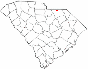
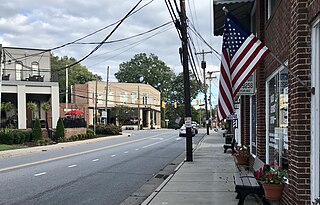
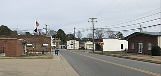
Ruby is a town in Chesterfield County, South Carolina, United States. The population was 360 at the 2010 census.

<span class="mw-page-title-main">Branchville, South Carolina</span> Town in South Carolina, United States

Branchville is a town in Orangeburg County, South Carolina, United States. The population was 1,024 at the 2010 census.

<span class="mw-page-title-main">Peterstown, West Virginia</span> Town in West Virginia, United States

Peterstown is a town in Monroe County, West Virginia, United States. The population was 456 at the 2020 census.

<span class="mw-page-title-main">Eleanor, West Virginia</span> Town in West Virginia, United States

Eleanor is a town in Putnam County, West Virginia, United States, along the Kanawha River. Its population was 1,548 at the 2020 census. It is part of the Huntington–Ashland metropolitan area. The town, named for Eleanor Roosevelt, was established as a New Deal project in the 1930s like other Franklin D. Roosevelt towns around the nation.

Colby is a town in Clark County in the U.S. state of Wisconsin. The population was 874 at the 2010 census.

Clear Lake is a town in Polk County, Wisconsin, United States. The population was 800 at the 2000 census. The Village of Clear Lake is located within the town.

References

  1. "ArcGIS REST Services Directory". United States Census Bureau. Retrieved September 20, 2022.
  2. 1 2 U.S. Geological Survey Geographic Names Information System: Faith, North Carolina
  3. 1 2 "U.S. Census website". United States Census Bureau . Retrieved January 31, 2008.
  4. "National Register Information System". National Register of Historic Places . National Park Service. July 9, 2010.
  5. "North Carolina Archives". sundown.tougaloo.edu. Retrieved March 6, 2021.
  6. "Census of Population and Housing". Census.gov. Retrieved June 4, 2015.
  7. "Explore Census Data". data.census.gov. Retrieved December 21, 2021.