Whitsett, North Carolina

Last updated

Whitsett, North Carolina
Guilford County North Carolina incorporated and unincorporated areas Whitsett highlighted.svg
Location in Guilford County and the state of North Carolina.
Coordinates: 36°04′42″N79°34′19″W / 36.07833°N 79.57194°W / 36.07833; -79.57194
Country United States
State North Carolina
County Guilford
Founded1884
Named for Whitsett Institute [1]
Area
[2]
  Total2.61 sq mi (6.76 km2)
  Land2.58 sq mi (6.69 km2)
  Water0.03 sq mi (0.07 km2)
Elevation
[3]
689 ft (210 m)
Population
 (2020)
  Total584
  Density226.09/sq mi (87.30/km2)
Time zone UTC-5 (Eastern (EST))
  Summer (DST) UTC-4 (EDT)
ZIP code
27377
Area code 336
FIPS code 37-73760 [4]
GNIS feature ID2406883 [3]
Website www.whitsettnc.com

Whitsett is a town in Guilford County, North Carolina, United States. The population was 584 at the 2020 census. [5]

Contents

History

The Daniel P. Foust House, Foust-Carpenter and Dean Dick Farms, Holly Gate, Low House, William Rankin and Elizabeth Wharton Smith House, Wadsworth Congregational Church, and Whitsett Historic District are listed on the National Register of Historic Places. [6]

In 2012, Lenovo announced it would open a manufacturing plant in Whitsett. [7]

Geography

According to the United States Census Bureau, the town has a total area of 2.8 square miles (7.3 km2), all land.

Demographics

Historical population
CensusPop.Note
2000 686
2010 590−14.0%
2020 584−1.0%
2022 (est.)593 [8] 1.5%
U.S. Decennial Census [9]

As of the census [4] of 2000, there were 686 people, 279 households, and 215 families residing in the town. The population density was 243.4 inhabitants per square mile (94.0/km2). There were 308 housing units at an average density of 109.3 per square mile (42.2/km2). The racial makeup of the town was 93.29% White, 5.98% African American, 0.15% Asian, and 0.58% from two or more races. Hispanic or Latino of any race were 0.73% of the population.

There were 279 households, out of which 26.9% had children under the age of 18 living with them, 64.5% were married couples living together, 7.2% had a female householder with no husband present, and 22.9% were non-families. 20.8% of all households were made up of individuals, and 8.6% had someone living alone who was 65 years of age or older. The average household size was 2.46 and the average family size was 2.82.

In the town, the population was spread out, with 20.4% under the age of 18, 6.6% from 18 to 24, 27.0% from 25 to 44, 28.7% from 45 to 64, and 17.3% who were 65 years of age or older. The median age was 42 years. For every 100 females, there were 100.0 males. For every 100 females age 18 and over, there were 97.8 males.

The median income for a household in the town was $44,250, and the median income for a family was $48,750. Males had a median income of $38,958 versus $26,250 for females. The per capita income for the town was $21,936. About 5.5% of families and 7.5% of the population were below the poverty line, including 14.3% of those under age 18 and 4.2% of those age 65 or over.

Related Research Articles

<span class="mw-page-title-main">Medora, Indiana</span> Town in Indiana, United States

Medora is a town in Carr Township, Jackson County, Indiana, United States. The population was 693 at the 2010 census.

<span class="mw-page-title-main">Green Level, North Carolina</span> Town in North Carolina, United States

Green Level is a town in Alamance County, North Carolina, United States. It is part of the Burlington, North Carolina Metropolitan Statistical Area. As of the 2020 census, the population was 3,156.

<span class="mw-page-title-main">Aulander, North Carolina</span> Town in North Carolina, United States

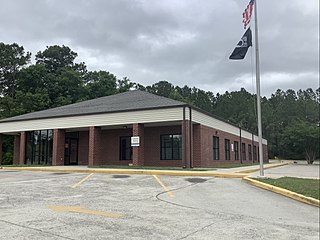
Aulander is a town in Bertie County, North Carolina, United States. The population was 895 at the 2010 census.

<span class="mw-page-title-main">Shallotte, North Carolina</span> Town in North Carolina, United States

Shallotte is a town in Brunswick County, North Carolina, United States. The population was 3,675 at the 2010 census. The Shallotte River passes through the town.

<span class="mw-page-title-main">Mount Pleasant, North Carolina</span> Town in North Carolina, United States

Mount Pleasant is a town located in eastern Cabarrus County, North Carolina, United States. As of the 2010 census, the town population was 1,652. The town center is located at the crossroads of Mount Pleasant Road and North Carolina Highway 73. NC Highway 49 skirts the town to the north on its way from Charlotte to Asheboro.

Brunswick is a town in Columbus County, North Carolina, United States. The population was 1,119 at the 2010 census.

<span class="mw-page-title-main">Youngsville, North Carolina</span> Town in North Carolina, United States

Youngsville is a town in Franklin County, North Carolina, United States. The population was 2,016 at the 2020 census.

<span class="mw-page-title-main">McLeansville, North Carolina</span> Census-designated place in North Carolina, United States

McLeansville is an unincorporated community and census-designated place (CDP) in Guilford County, North Carolina, United States. The population was 1,021 at the 2010 census.

<span class="mw-page-title-main">Pleasant Garden, North Carolina</span> Town in North Carolina, United States

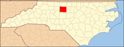
Pleasant Garden is a town in Guilford County, North Carolina, United States.

<span class="mw-page-title-main">Clyde, North Carolina</span> Town in North Carolina, United States

Clyde is a town in Haywood County, North Carolina, United States. The 2010 census recorded the population at 1,223 people. It is part of the Asheville Metropolitan Statistical Area.

<span class="mw-page-title-main">Bailey, North Carolina</span> Town in North Carolina, United States

Bailey is a town in Nash County, North Carolina, United States. It is part of the Rocky Mount, North Carolina Metropolitan Statistical Area. The population was 566 at the 2020 census.

<span class="mw-page-title-main">Franklinville, North Carolina</span> Town in North Carolina, United States

Franklinville is a town in Randolph County, North Carolina, United States. The population was 1,164 at the 2010 census.

<span class="mw-page-title-main">Ruth, North Carolina</span> Town in North Carolina, United States

Ruth is a town in Rutherford County, North Carolina, United States. The population was 440 at the 2010 census.

<span class="mw-page-title-main">Pilot Mountain, North Carolina</span> Town in North Carolina, United States

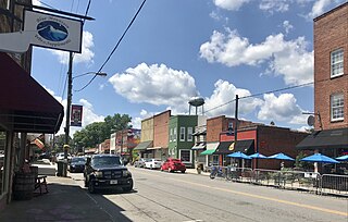
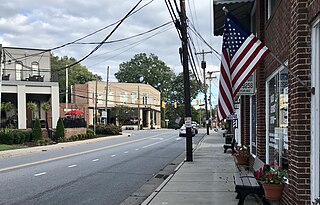
Pilot Mountain is a town in Surry County, North Carolina, United States. The population was 1,443 at the 2020 census. It is named for the nearby landmark of Pilot Mountain, a distinctive geological formation.

<span class="mw-page-title-main">Black Creek, North Carolina</span> Town in North Carolina, United States

Black Creek is a town in Wilson County, North Carolina, United States. The population was 769 at the 2010 census.

<span class="mw-page-title-main">Perry Township, Fayette County, Pennsylvania</span> Township in Pennsylvania, United States

Perry Township is a township in Fayette County, Pennsylvania, United States. The population was 2,339 at the 2020 census, a decline from the figure of 2,552 tabulated in 2010. The Frazier School District serves the township.

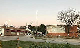
Ulmer is a town in Allendale County, South Carolina, United States. The population was 65 at the 2020 census.

<span class="mw-page-title-main">St. Stephen, South Carolina</span> Town in South Carolina, United States

St. Stephen is a town in Berkeley County, South Carolina, United States. The population was 1,697 at the 2010 census.

<span class="mw-page-title-main">Great Falls, South Carolina</span> Town in South Carolina, United States

Great Falls is a town in Chester County, South Carolina, United States and is located fourteen miles southwest of Lancaster, South Carolina. The population was 1,951 at the 2020 census.

<span class="mw-page-title-main">Newsoms, Virginia</span> Town in Virginia, United States

Newsoms is a town in Southampton County, Virginia, United States. The population was 282 at the 2000 census.

References

  1. "North Carolina Gazetteer" . Retrieved November 24, 2023.
  2. "ArcGIS REST Services Directory". United States Census Bureau. Retrieved September 20, 2022.
  3. 1 2 U.S. Geological Survey Geographic Names Information System: Whitsett, North Carolina
  4. 1 2 "U.S. Census website". United States Census Bureau . Retrieved January 31, 2008.
  5. "Explore Census Data". data.census.gov. Retrieved August 23, 2023.
  6. "National Register Information System". National Register of Historic Places . National Park Service. July 9, 2010.
  7. Shah, Agam (October 2, 2012). "Lenovo to open first U.S. manufacturing plant in N.C." Computerworld. Retrieved October 21, 2021.
  8. "Annual Estimates of the Resident Population for Incorporated Places in North Carolina: April 1, 2020 to July 1, 2022". Census.gov. Retrieved April 11, 2024.
  9. "Census of Population and Housing". Census.gov. Retrieved June 4, 2015.