Gorman, North Carolina

Last updated

Gorman, North Carolina
Durham County North Carolina incorporated and unincorporated areas Gorman highlighted.svg
Location in Durham County and the state of North Carolina
Coordinates: 36°02′30″N78°48′33″W / 36.04167°N 78.80917°W / 36.04167; -78.80917
Country United States
State North Carolina
County Durham
Area
[1]
  Total2.96 sq mi (7.66 km2)
  Land2.90 sq mi (7.51 km2)
  Water0.06 sq mi (0.14 km2)
Elevation
[2]
328 ft (100 m)
Population
 (2020)
  Total1,104
  Density380.56/sq mi (146.92/km2)
Time zone UTC-5 (Eastern (EST))
  Summer (DST) UTC-4 (EDT)
ZIP code
27704 [3]
Area code(s) 919 and 984
FIPS code 37-27120 [4]
GNIS feature ID2402539 [2]

Gorman is a census-designated place (CDP) in Durham County, North Carolina, United States. The population was 1,011 at the 2010 census. [5]

Contents

Geography

Gorman is located in east-central Durham County between the city of Durham to the southwest and Falls Lake on the Neuse River to the northeast. Interstate 85 forms the northwestern border of the community, with access from exits 180, 182, and 183. The main road through the community is East Geer Street, running roughly parallel to I-85.

According to the United States Census Bureau, the Gorman CDP has a total area of 2.93 square miles (7.60 km2), of which 2.88 square miles (7.45 km2) is land and 0.054 square miles (0.14 km2), or 1.89%, is water. [5]

Demographics

Historical population
CensusPop.Note
2020 1,104
U.S. Decennial Census [6]

2020 census

Gorman racial composition [7]
RaceNumberPercentage
White (non-Hispanic)45741.39%
Black or African American (non-Hispanic)11210.14%
Asian 90.82%
Pacific Islander 40.36%
Other/Mixed 343.08%
Hispanic or Latino 48844.2%

As of the 2020 United States census, there were 1,104 people, 311 households, and 246 families residing in the CDP.

2000 census

As of the census [4] of 2000, there were 1002 people, 406 households, and 291 families residing in the CDP. The population density was 325.1 inhabitants per square mile (125.5/km2). There were 428 housing units at an average density of 138.9 per square mile (53.6/km2). The racial makeup of the CDP was 82.04% White, 15.97% African American, 0.10% Native American, 0.10% Asian, 1.00% from other races, and 0.80% from two or more races. Hispanic or Latino of any race were 4.29% of the population.

There were 406 households, out of which 27.6% had children under the age of 18 living with them, 55.7% were married couples living together, 13.5% had a female householder with no husband present, and 28.3% were non-families. 24.4% of all households were made up of individuals, and 8.1% had someone living alone who was 65 years of age or older. The average household size was 2.47 and the average family size was 2.91.

In the CDP, the population was spread out, with 22.1% under the age of 18, 6.8% from 18 to 24, 30.2% from 25 to 44, 26.7% from 45 to 64, and 14.2% who were 65 years of age or older. The median age was 39 years. For every 100 females, there were 93.8 males. For every 100 females age 18 and over, there were 88.2 males.

The median income for a household in the CDP was $42,236, and the median income for a family was $43,977. Males had a median income of $36,143 versus $30,789 for females. The per capita income for the CDP was $19,083. About 9.3% of families and 6.7% of the population were below the poverty line, including 6.9% of those under age 18 and 5.9% of those age 65 or over.

Related Research Articles

<span class="mw-page-title-main">Willow Valley, Arizona</span> Census-designated place in Arizona, United States

Willow Valley is an unincorporated community and census-designated place (CDP) in Mohave County, Arizona, United States. The population was 1,059 as of the 2020 census.

<span class="mw-page-title-main">East Sahuarita, Arizona</span> Community in Pima County, Arizona

East Sahuarita was a census-designated place (CDP) in Pima County, Arizona, United States. The population was 1,419 at the 2000 census. The CDP comprises the unincorporated neighborhoods east of incorporated Sahuarita.

<span class="mw-page-title-main">Onyx, California</span> Census-designated place in California, United States

Onyx is a census-designated place (CDP) in Kern County, California, United States. Onyx is located 3.5 miles (6 km) east-northeast of Weldon in the South Fork Valley at an elevation of 2,795 feet (852 m). The population was 475 at the 2010 census, down from 476 at the 2000 census.

<span class="mw-page-title-main">Glasgow Village, Missouri</span> CDP in Missouri, United States

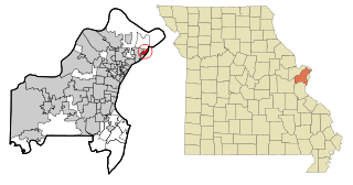
Glasgow Village is a census-designated place (CDP) in St. Louis County, Missouri, United States. The population was 5,429 at the 2010 census.

<span class="mw-page-title-main">Woodlawn, North Carolina</span> Census-designated place in North Carolina, United States

Woodlawn is a census-designated place in Alamance County, North Carolina, United States.

<span class="mw-page-title-main">Sherrills Ford, North Carolina</span> Unincorporated community in North Carolina, United States

Sherrills Ford is an unincorporated community and former census-designated place (CDP) in Catawba County, North Carolina, United States. The population was 941 at the 2000 census. For the 2010 census it was included within the Lake Norman of Catawba CDP. It is part of the Hickory-Lenoir-Morganton Metropolitan Statistical Area.

<span class="mw-page-title-main">Buies Creek, North Carolina</span> Census-designated place in North Carolina, United States

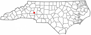
Buies Creek is a census-designated place (CDP) located in the Neills Creek Township of Harnett County, North Carolina, United States. It is the home of Campbell University. The population was 3,253 at the 2020 census, up from 2,942 in 2010. Buies Creek is a part of the Dunn Micropolitan Area, which is also a part of the greater Raleigh–Durham–Cary Combined Statistical Area (CSA) as defined by the United States Census Bureau.

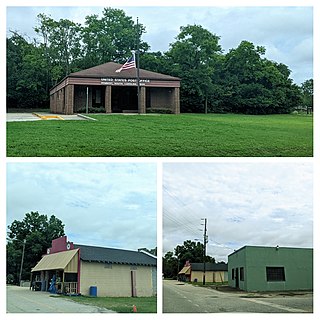
Elrod is a census-designated place (CDP) in Robeson County, North Carolina, United States. The population was 441 at the 2000 census.

Raemon is a census-designated place (CDP) in Robeson County, North Carolina, United States. The population was 212 at the 2000 census.

<span class="mw-page-title-main">White Plains, North Carolina</span> CDP in North Carolina, United States

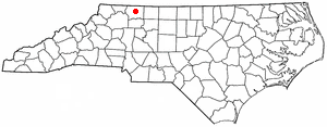
White Plains is a census-designated place (CDP) in Surry County, North Carolina, United States. The population was 1,049 at the 2000 census.

Mar-Mac is a census-designated place (CDP) in Wayne County, North Carolina, United States. The population was 3,011 at the 2007 census. It is included in the Goldsboro, North Carolina Metropolitan Statistical Area.

<span class="mw-page-title-main">Orchard Hills, Pennsylvania</span> Census-designated place in Pennsylvania, United States

Orchard Hills is a census-designated place (CDP) in Armstrong County, Pennsylvania, United States. The population was 1,949 at the 2020 census.

<span class="mw-page-title-main">Gloverville, South Carolina</span> Census-designated place in South Carolina, United States of America

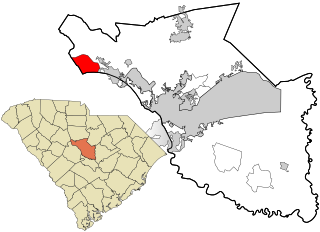
Gloverville is a census-designated place (CDP) in Aiken County, South Carolina, United States. The population was 2,831 at the 2010 census. It is part of the Augusta, Georgia metropolitan area. Gloverville is located in historic Horse Creek Valley.

<span class="mw-page-title-main">Homeland Park, South Carolina</span> CDP in South Carolina, United States

Homeland Park is a census-designated place (CDP) in Anderson County, South Carolina. The population was 6,445 at the 2020 census.

<span class="mw-page-title-main">North Hartsville, South Carolina</span> Census-designated place in South Carolina, United States

North Hartsville is a census-designated place (CDP) in Darlington County, South Carolina, United States. The population was 3,251 at the 2010 census. It is part of the Florence Metropolitan Statistical Area and the Hartsville Urban Cluster.

<span class="mw-page-title-main">Dentsville, South Carolina</span> Census-designated place in South Carolina, United States

Dentsville is a census-designated place (CDP) in Richland County, South Carolina, United States. The population was 14,062 at the 2010 census. It is part of the Columbia, South Carolina, Metropolitan Statistical Area.

<span class="mw-page-title-main">Lake Murray of Richland, South Carolina</span> Census-designated place in South Carolina, United States

Lake Murray of Richland is a census-designated place (CDP) in Richland County, South Carolina, United States. The population was 5,484 at the 2010 census. It is part of the Columbia, South Carolina Metropolitan Statistical Area.

<span class="mw-page-title-main">Rembert, South Carolina</span> Town in South Carolina, United States

Rembert is a town in Sumter County, South Carolina, United States. The population was 306 at the 2010 census, a decline from 406 in 2000. It is included in the Sumter, South Carolina Metropolitan Statistical Area.

<span class="mw-page-title-main">Lake Ketchum, Washington</span> CDP in Washington, United States

Lake Ketchum is a census-designated place (CDP) in Snohomish County, Washington, United States. The population was 930 at the 2010 census.

<span class="mw-page-title-main">Durham (CDP), New Hampshire</span> Census-designated place in New Hampshire, United States

Durham is a census-designated place (CDP) and the main village in the town of Durham in Strafford County, New Hampshire, United States. The population of the CDP was 11,147 at the 2020 census, out of 15,490 in the entire town. The CDP is home to the University of New Hampshire.

References

  1. "ArcGIS REST Services Directory". United States Census Bureau. Retrieved September 20, 2022.
  2. 1 2 U.S. Geological Survey Geographic Names Information System: Gorman, North Carolina
  3. "Gorman NC ZIP Code". zipdatamaps.com. 2023. Retrieved February 17, 2023.
  4. 1 2 "U.S. Census website". United States Census Bureau . Retrieved January 31, 2008.
  5. 1 2 "Geographic Identifiers: 2010 Demographic Profile Data (G001): Gorman CDP, North Carolina". U.S. Census Bureau, American Factfinder. Archived from the original on February 13, 2020. Retrieved December 2, 2015.
  6. "Census of Population and Housing". Census.gov. Retrieved June 4, 2016.
  7. "Explore Census Data". data.census.gov. Retrieved December 20, 2021.