
The Bronx is a borough of New York City, coextensive with Bronx County, in the U.S. state of New York. It is south of Westchester County; north and east of the New York City borough of Manhattan, across the Harlem River; and north of the New York City borough of Queens, across the East River. The Bronx, the only New York City borough not primarily located on an island, has a land area of 42 square miles (109 km2) and a population of 1,472,654 at the 2020 census. Of the five boroughs, it has the fourth-largest area, fourth-highest population, and third-highest population density.

Little Saigon is a name given to ethnic enclaves of expatriate Vietnamese mainly in English-speaking countries. Alternate names include Little Vietnam and Little Hanoi, depending on the enclave's political history. To avoid political undertones due to the renaming of Saigon to Ho Chi Minh City, it is occasionally called by the neutral name Vietnamtown. Saigon is the former name of the capital of the former South Vietnam, where a large number of first-generation Vietnamese immigrants emigrating to the United States originate from, whereas Hanoi is the current capital of Vietnam.

A Koreatown (Korean: 코리아타운), also known as a Little Korea or Little Seoul, is a Korean-dominated ethnic enclave within a city or metropolitan area outside the Korean Peninsula.

A Little Manila, also known as a Manilatown or Filipinotown, is a community with a large Filipino immigrant and descendant population. Little Manilas are enclaves of Overseas Filipinos consisting of people of Filipino origin living outside of the Philippines.

University Circle is a district in the neighborhood of University on the East Side of Cleveland, Ohio. It is home to the Cleveland Museum of Art, Severance Hall, the Cleveland Institute of Art, the Cleveland Cinematheque, Case Western Reserve University, the Cleveland Institute of Music, the Museum of Contemporary Art Cleveland, the Cleveland Botanical Garden, historic Lake View Cemetery, the Cleveland Museum of Natural History, and University Hospitals/Case Medical Center.

Historic Filipinotown is a neighborhood in the city of Los Angeles.

Bedford Park is a residential neighborhood in the northwest Bronx, New York City, adjacent to the New York Botanical Garden. Its boundaries, starting from the north and moving clockwise, are: Mosholu Parkway to the north, Webster Avenue to the east, East 196th Street to the south, and Jerome Avenue to the west.

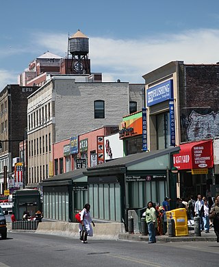
Morris Park is a neighborhood in the New York City borough of the Bronx. Its approximate boundaries, starting from the north and moving clockwise, are Neill Avenue and Pelham Parkway to the north, Eastchester Road to the east, the Amtrak Northeast Corridor tracks and Sackett Avenue to the east and south, and Bronxdale Avenue and White Plains Road to the west. It borders the neighborhoods of Van Nest to its southwest and Pelham Parkway to its northeast. Williamsbridge Road and Morris Park Avenue are the primary thoroughfares.

Van Cortlandt Park is a 1,146-acre (464 ha) park located in the borough of the Bronx in New York City. Owned by the New York City Department of Parks and Recreation, it is managed with assistance from the Van Cortlandt Park Alliance. The park, the city's third-largest, was named for the Van Cortlandt family, which was prominent in the area during the Dutch and English colonial periods.

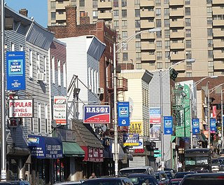
Van Nest is a working-class neighborhood geographically located in the East Bronx section of the Bronx, New York City. Going clockwise, its boundaries are Bronxdale Avenue to the northeast, the Amtrak tracks to the southeast, and Bronx Park to the west. Van Nest predated Morris Park by 20 years and is considered the older of the two communities. Morris Park Avenue and White Plains Road are the primary commercial thoroughfares through Van Nest.

Bronx Community Board 11 (CB11) is a small unit of the City of New York (NYC), whose district encompasses the neighborhoods of Allerton, Indian Village, Morris Park, Pelham Gardens, Pelham Parkway (neighborhood), Van Nest and other areas in the borough of the Bronx. Coterminous with the 49th NYPD Precinct, its district is delimited by Bronx Park East and the Bronx River Parkway to the west, Adee Avenue, Boston Road and East Gun Hill Road to the north, the Hutchinson River Parkway to the east, and East Tremont Avenue to the south.

Pelham Parkway is a working- and middle-class residential neighborhood geographically located in the center of the Bronx, a borough of New York City in the United States. Its boundaries, starting from the north and moving clockwise are: Pelham Parkway South, to the east the IRT Dyre Avenue Line tracks and to the south Bronxdale Avenue and to the west, Bronx Park East. White Plains Road is the primary commercial thoroughfare through Pelham Parkway. The neighborhood is named after Pelham Parkway, a major west–east parkway that travels through the East Bronx.
India Square, home to the highest concentration of Asian Indians in the Western Hemisphere, and known as "Little India," is a South Asian-focused commercial and restaurant district in the Bombay, Journal Square, and Marion Section neighborhoods of Jersey City, New Jersey, U.S.

Since its founding in 1625 by Dutch traders as New Amsterdam, New York City has been a major destination for immigrants of many nationalities who have formed ethnic enclaves, neighborhoods dominated by one ethnicity. Freed African American slaves also moved to New York City in the Great Migration and the later Second Great Migration and formed ethnic enclaves. These neighborhoods are set apart from the main city by differences such as food, goods for sale, or even language. Ethnic enclaves provide inhabitants security in work and social opportunities, but limit economic opportunities, do not encourage the development of English speaking, and keep immigrants in their own culture.

Chinatowns are enclaves of Chinese people outside of China. The first Chinatown in the United States was San Francisco's Chinatown in 1848, and many other Chinatowns were established in the 19th century by the Chinese diaspora on the West Coast. By 1875, Chinatowns had emerged in eastern cities such as New York City, Boston, Pittsburgh, and Philadelphia. The Chinese Exclusion Act of 1882 barred Chinese immigration to the United States, but the Magnuson Act of 1943 repealed it, and the population of Chinatowns began to rise again.
Koreatown, Queens, in the New York City borough of Queens, is one of the largest and fastest-growing ethnic Korean enclaves outside Korea. It is largely oriented around Northern Boulevard.
Westchester Square is a residential neighborhood geographically located in the eastern section of the New York City borough of the Bronx. Its boundaries, starting from the north and moving clockwise are: East Tremont Avenue and Silver Street, Blondell Avenue and Westchester Creek to the east, Waterbury Avenue to the south and Castle Hill Avenue to the west. The main roadways through Westchester Square are East Tremont Avenue, Westchester Avenue and Williamsbridge Road.
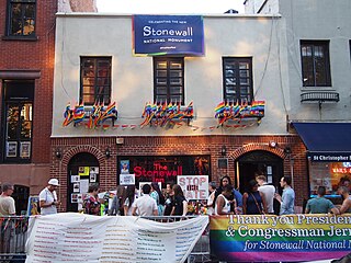
New York City has been described as the gay capital of the world and the central node of the LGBTQ+ sociopolitical ecosystem, and is home to one of the world's largest and most prominent LGBTQ+ populations. Brian Silverman, the author of Frommer's New York City from $90 a Day, wrote the city has "one of the world's largest, loudest, and most powerful LGBT communities", and "Gay and lesbian culture is as much a part of New York's basic identity as yellow cabs, high-rise buildings, and Broadway theatre". LGBT travel guide Queer in the World states, "The fabulosity of Gay New York is unrivaled on Earth, and queer culture seeps into every corner of its five boroughs". LGBTQ advocate and entertainer Madonna stated metaphorically, "Anyways, not only is New York City the best place in the world because of the queer people here. Let me tell you something, if you can make it here, then you must be queer."
Oak Tree Road is a predominantly South Asian shopping, business, and dining district centered on a road designated County Route 604 in Middlesex County, in Central New Jersey. The district, which has been called "Little India," is set amidst a suburban residential area that is home to many South Asian families.

Parkchester/Van Nest station is a planned passenger rail station on the Metro-North Railroad's New Haven Line, to be located within Bronx Community Board 11 in Van Nest and just north of the Parkchester neighborhood of the Bronx in New York City. The station is planned to open in 2027 as part of the Penn Station Access project, which will add four stations in the Bronx. It will be located east of Unionport Road, with entrance from East Tremont Avenue.
