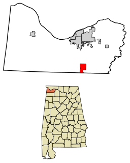
Littleville is a town located on the southern border of Colbert County, Alabama, United States, and extends into Franklin County. It is part of the Florence - Muscle Shoals Metropolitan Statistical Area known as "The Shoals". As of the 2010 census, the population of the town was 1,011.

Hopewell is a town in Ontario County, New York, United States. The population was 3,747 at the 2010 census.
Avon is a town in Livingston County, New York, United States. It is south of Rochester. The town population was 7,146 at the 2010 census. The village of Avon is in the northwest part of the town.

Silver Lake is a town that existed near the Tonopah and Tidewater Railroad, six miles north of Baker, in the Mojave Desert of San Bernardino County, California.
Manchester is a town in Ontario County, New York, United States. The population was 9,395 at the 2010 census. The town was named after one of its villages, which in turn was named after the original Manchester in England. It was formed in 1822 from the town of Farmington.
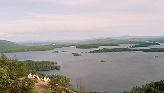
The Lakes Region of New Hampshire is located in the east-central part of the state, south of the White Mountains Region and extending to the Maine border. It is named for the numerous lakes in the region, the largest of which are Lake Winnipesaukee, Lake Winnisquam, Squam Lake, and Newfound Lake. The area comprises all of Belknap County, the southern portion of Carroll County, the eastern portion of Grafton County, and the northern portions of Strafford County and Merrimack County. The largest municipality is the city of Laconia.
Gautelisvatnet (Norwegian) or Guovdelisjávri (Northern Sami) is a lake that is located on the border of Norway and Sweden, about 50 kilometres (31 mi) southeast of the town of Narvik. The Norwegian side lies in Narvik Municipality in Nordland county and the Swedish side lies in Gällivare Municipality in Norrbotten County. The 17.67-square-kilometre (6.82 sq mi) lake has a dam on the northern end and the water is used for hydropower. After the dam was built, the lake grew and merged with the lake Vannaksvatnet to the south. The lake Unna Guovdelisjávri lies just to the east of this lake.
Litlumvatnet (Norwegian), Lill-Uman (Swedish), or Jovsjaevrie (Southern Sami) is a lake on the border of Norway and Sweden. The Norwegian side lies in Rana Municipality in Nordland county and the Swedish side lies in Storuman Municipality in Västerbotten County. The lake lies about 40 kilometres (25 mi) southeast of the town of Mo i Rana. The lake is 5.24 square kilometres (2.02 sq mi) and about 1.8 square kilometres (0.69 sq mi) lies inside Norway and the rest lies in Sweden.
Mjåvatnet is a lake that lies in the municipality of Vefsn in Nordland county, Norway. The long, skinny, 2.61-square-kilometre (1.01 sq mi) lake lies between the lakes Ømmervatnet and Fustvatnet, about 15 kilometres (9.3 mi) northeast of the town of Mosjøen. The European route E6 highway passes along the west coast of the lake.
Nedrevatnet or Nervatnet is a lake that lies in Fauske Municipality in Nordland county, Norway. The 4.8-square-kilometre (1.9 sq mi) lake lies just east of the town of Fauske. The lake Øvrevatnet flows into this lake and the water flows out of the Nedrevatnet into the Skjerstad Fjord. The E6 highway and the Nordland Line run along the western edge of this lake.
Iešjávri is a large lake on the border of the three municipalities of Alta, Kautokeino, and Karasjok in Troms og Finnmark county, Norway. The lake lies on the Finnmarksvidda plateau about 50 kilometres (31 mi) northwest of the village of Karasjok, about 30 kilometres (19 mi) northeast of the village of Masi, and about 45 kilometres (28 mi) southeast of the town of Alta.
Vigdarvatnet is a lake in the municipality of Sveio in Vestland county, Norway. A small arm off the main lake juts to the south and runs along the municipal-county border between Sveio in Vestland county and the town of Haugesund in Rogaland county. The 10-kilometre (6.2 mi) long lake forms a U-shape. It is fed by the nearby lake Stakkastadvatnet to the south, and it empties into the Ålfjorden, a small fjord arm off the main Hardangerfjorden. The village of Sveio lies on the northwestern shore of the lake.
Nordmannslågen is a lake in the municipality of Eidfjord in Vestland county, Norway. At 11.09 square kilometres (4.28 sq mi), it is the largest lake in Hordaland county. The lake lies on the great Hardangervidda plateau in the central part of the Hardangervidda National Park. The lake lies about 35 kilometres (22 mi) southeast of the village of Eidfjord and about 50 kilometres (31 mi) northeast of the town of Odda. The lake is part of the headwaters of the river Numedalslågen.

Stakkastadvatnet is a lake on the border of Rogaland and Vestland counties in Norway. The 2.92-square-kilometre (1.13 sq mi) lake mostly lies in Rogaland along the municipal borders of Haugesund and Tysvær. A very small portion of the northern part of the lake crosses over into the municipality of Sveio in Vestland county. The lake lies about 6 kilometres (3.7 mi) northeast of the town of Haugesund. The lake has a small dam on the northwestern edge of the lake. The natural outlet of the lake flows through the dam and into the nearby lake Vigdarvatnet, located to the north.

Little Sunapee Lake is a 486-acre (197 ha) water body located primarily in Merrimack County in central New Hampshire, United States, in the town of New London. A small portion of the lake crosses into neighboring Springfield in Sullivan County. The lake is sometimes referred to as "Twin Lakes" due to a long, narrow peninsula which nearly cuts the lake in half. Water flowing out of the lake passes through Goose Pond and Otter Pond before entering Lake Sunapee. Bucklin Beach is a Town of New London recreation area at the east end of the lake.

Nedre Roasten is a lake in Femundsmarka National Park on the border of Innlandet and Trøndelag counties in Norway. The 2.29-square-kilometre (0.88 sq mi) lake sits on the border of the municipalities of Engerdal in Innlandet county and Røros in Trøndelag county. Nedre Roasten is about 50 kilometres (31 mi) southeast of the town of Røros and just under 9 kilometres (5.6 mi) from the border with Sweden. The lake lies about 5 kilometres (3.1 mi) east of the lake Femunden and about 8 kilometres (5.0 mi) west of the lake Rogen which sits along the Swedish border.
The following radio stations broadcast on FM frequency 100.1 MHz:
Leksdalvatnet is a lake in Trøndelag county, Norway that lies in the municipalities of Steinkjer and Verdal. It is located south of the town of Steinkjer and northeast of the town of Verdalsøra, about 6 kilometres (3.7 mi) east of the Trondheimsfjord. The 21.73-square-kilometre (8.39 sq mi) lake sits at an elevation of 70 metres (230 ft) above sea level. It is drained by Figgja.

The Canandaigua Outlet is a main tributary which feeds the Erie Canal and Clyde River in Wayne County, New York, United States. It begins at Canandaigua Lake in nearby Ontario County and flows approximately 34 miles (55 km) north before emptying into the Erie Canal in the hamlet of Lyons. A number of tributaries feed the Canandaigua Outlet along its route. It is the primary outflow for Canandaigua Lake.
Chartered in 1886, the Canandaigua Street Railroad was a local streetcar line serving the lakeside city of Canandaigua, New York beginning in 1887. The railroad was sold to the Canandaigua Electric Light and Railroad which rebuilt and electrified the line in 1892. The Ontario Light and Traction Company purchased it in 1900, and leased the line to the Rochester and Eastern Rapid Railway in 1903. In 1905, the line came under the control of the Mohawk Valley Company, and in turn, New York State Railways in 1909. Operation was converted to bus operation some time in the 1920s, but this service ended when the Rochester and Eastern Rapid Railway shut down on July 31, 1930. The lease of the former Canandaiua lines was allowed to lapse.


