Alewife Brook Reservation is a Massachusetts state park and urban wild located in Cambridge, Arlington, and Somerville. The park is managed by the state Department of Conservation and Recreation and was established in 1900. It is named for Alewife Brook, which was also historically known as Menotomy River, a tributary of the Mystic River.
The Satucket River is 5.5-mile-long (8.9 km) river in southeastern Massachusetts within the Taunton River Watershed. It flows generally west from Robbins Pond in East Bridgewater, and into the Matfield River.
The Johns River, in northern New Hampshire, arises at Cherry Pond in Jefferson and runs approximately 14 miles (23 km), generally northwest, to the Connecticut River. It passes through Hazens Pond, near the Mount Washington Regional Airport, traverses the town of Whitefield, where it is crossed by U.S. Highway 3, and then crosses the town of Dalton before joining the Connecticut. It is named for an early hunter and trapper of the area, John Glines, who established a fishing and hunting camp in the area in the 18th century. Another nearby river, the Israel River, is named for John's brother Israel.

The Seven Mile River or Sevenmile River is a 9.6-mile-long (15.4 km) stream in central Massachusetts. It heads at Browning Pond, at the Oakham and Spencer border, and travels south through Spencer, following a short distance from State Route 31. It crosses under Route 31 the highway becomes Pleasant Street, then continues south along Old Meadow Road and under State Route 9 near the junction of State Route 49. It then parallels Route 9 to its south until it joins the East Brookfield River between Lake Lashaway and Quaboag Pond.
The River Ems is a river that flows through the English counties of West Sussex and Hampshire, before flowing into Chichester Harbour and thence the sea. Its source is about 0.5 miles (800 m) east of Stoughton, in West Sussex, and its mouth is at Emsworth, in Hampshire.
Monponsett Pond, also called Monponsett Lake and the Twin Lakes, originally one lake is dissected by route 58 into a system of two ponds, West and East, mostly in Halifax, Massachusetts, with a small portion of West Monponsett Pond extending into Hanson. The western basin is 282 acres (1.14 km2), and the eastern basin is 246 acres (1.00 km2). The average depth of both ponds is seven feet and the maximum depth is 13 feet (4.0 m). The outflow is Stump Brook, a tributary of Poor Meadow Brook, in the northwestern part of West Monponsett Pond. The pond is part of the Taunton River Watershed. Occasionally during water shortages water from this pond is diverted into Silver Lake, the principal water supply for the City of Brockton.

Robbins Pond is a 124-acre (0.50 km2) warm water pond in East Bridgewater and Halifax, Massachusetts. It is part of the Taunton River Watershed. The inflow is Poor Meadow Brook, and the outflow is the Satucket River.The water is brown in color with a transparency of five feet, and the bottom is a mixture of sand and gravel. Average depth is four feet and maximum depth is just ten feet. There are 1.7 miles (2.7 km) of shoreline.
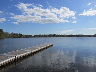
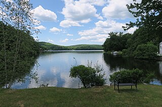
Silver Lake is a 640-acre (2.6 km2) lake in Pembroke, Kingston, and Plympton, Massachusetts, south of Route 27 and east of Route 36. The Pembroke/Plympton town line is entirely within the lake, and a portion of the western shoreline of the lake is the town line with Halifax. It used to be called the Jones River Pond, but its name was changed to Silver Lake in the 1800s in a marketing effort to sell more ice from it. The lake is the principal water supply for the City of Brockton, whose water treatment plant is on Route 36 in Halifax. The inflow of the pond is Tubbs Meadow Brook, and the pond is the headwaters of the Jones River. Occasionally water is diverted into Silver Lake from Monponsett Pond in Halifax and Furnace Pond in Pembroke whenever there is a water shortage. Although the lake is a reservoir, which prevents recreational activities to keep the drinking water clean, the water from the diversions are not and can pump in contaminated water. Monponsett Pond in particular has has reoccurring toxic algae growths which get transferred into the lake. It is supposed to be the main source of the Jones River by contributing aboot twenty percent of the river's flow, but the Forge Pond Dam near its base lets out minimal, some years no, water to the river. This also prevents migratory aquatic animals from reaching the lake. Brockton prefers to keep the dam to have more accessible water. Access to the pond is through Silver Lake Sanctuary, a 92-acre (370,000 m2) property where one can walk, hike and fish, which is located at the end of Barses Lane, off Route 27 in Kingston.
Furnace Pond is a 107-acre (0.43 km2) pond in Pembroke, Massachusetts. The pond is located southeast of Oldham Pond which is connected to Furnace Pond by an inlet, and east of Great Sandy Bottom Pond. The maximum depth is nine feet. The pond is a Class A Public Water Source for the Brockton Water Commission. Water from this pond is diverted into Silver Lake through Tubbs Meadow Brook, the pond's outflow, whenever there is a water shortage there. The Furnace Pond Neighborhood Association maintains a semi-public beach along the pond.
Bridge Island Meadows is an 80-acre (320,000 m2) nature reserve owned by The Trustees of Reservations on the floodplains of the upper Charles River in Millis, Massachusetts. The property was a 1974 gift from Dr. and Mrs. John D. Constable to the Trustees of Reservations. The property is surrounded by wetlands, and is only accessible by boat.
Vine Brook is a brook in Middlesex County, United States. According to the History of Bedford, Vine Brook is "an important tributary of Shawsheen River." The book also states it as an excellent source of water-power in the 17th to 19th Centuries.

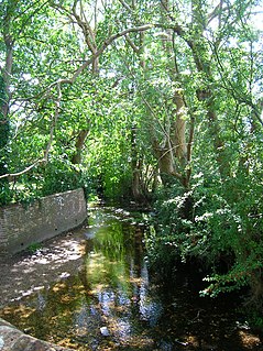
West End Brook is a small stream in southern England. It rises near the Hampshire village of Tadley. Its name is probably related to the parish, and village, it passes through for some of its course: Mortimer West End.
Harrisville Pond is a 138-acre (0.56 km2) water body located in Cheshire County in southwestern New Hampshire, United States, in the town of Harrisville. It is one of many lakes and ponds along Nubanusit Brook, a tributary of the Contoocook River. Water from Nubanusit Lake flows via the Great Meadows into the pond on the north side and out of the pond at two dams on the south side. One dam allows the level of the pond to be raised or lowered and also adjusts the flow through the mills that span that part of the outlet, while the other dam is made of large stones and sandbags. The village of Harrisville is located at the outlet of the pond.

Weir River is a short stream and estuary that empties into Hingham Bay, part of Boston Harbor in Massachusetts, United States. The name is attributed to the location of a fishing weir in the stream. The river gives its name to a larger watershed and Weir River Farm, a park and nature reserve owned by The Trustees of Reservations.

Bigelow Brook is a river in northeastern Connecticut, flowing from Mashapaug Lake in Union to its confluence with the Still River in Eastford.

Fir and Pond Woods is a 29 hectare nature reserve in Potters Bar in Hertfordshire. It is managed by the Herts and Middlesex Wildlife Trust. It is two separate woods, with Fir Wood connected by a short footpath to the large Pond Wood to the south.
The Belgrade Lakes are a chain of lakes around Belgrade, Maine. The flow sequence is from East Pond to North Pond to Great Pond to Long Pond to Messalonskee Lake and thence via Messalonskee Stream to the Kennebec River at Waterville. The lakes have long been an important resort area for fishing, boating, and swimming; and shoreline development includes residences for individuals employed in the cities of Waterville and Augusta.
Northwood Meadows State Park is a 675-acre (273 ha) state park in the town of Northwood, New Hampshire. Activities included nature walks, hiking, picnicking, fishing, non-motorized boating, biking, snowmobiling, and cross-country skiing. The wooded park has a vast wetlands area includes a pond created by a dammed brook.