Canapitsit Channel

Last updated
Canapitsit Channel
Relief map of USA Massachusetts.png
Red pog.svg
Canapitsit Channel
Location of Canapitsit Channel within Massachusetts
Usa edcp relief location map.png
Red pog.svg
Canapitsit Channel
Canapitsit Channel (the United States)
Coordinates 41°25′24″N70°54′28″W / 41.4234412°N 70.9078122°W / 41.4234412; -70.9078122 Coordinates: 41°25′24″N70°54′28″W / 41.4234412°N 70.9078122°W / 41.4234412; -70.9078122 [1]
Part of Atlantic Ocean

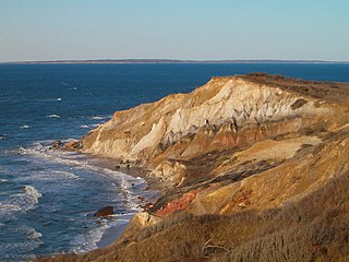
Canapitsit Channel is a channel that runs from Cuttyhunk Harbor to the Vineyard Sound and separates Nashawena Island from Cuttyhunk Island, two of the Elizabeth Islands off Cape Cod, Massachusetts. It is one of four straits allowing maritime passage between Buzzards Bay and the Vineyard Sound. The others are Quick's Hole, Robinson's Hole and Woods Hole. Canapitsit is an Indian word meaning "current passage".

Channel (geography) A type of landform in which part of a body of water is confined to a relatively narrow but long region

In physical geography, a channel is a type of landform consisting of the outline of a path of relatively shallow and narrow body of fluid, most commonly the confine of a river, river delta or strait. The word is cognate to canal, and sometimes takes this form, e.g. the Hood Canal.

Cuttyhunk Harbor bay in Dukes County, United States of America

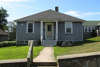
Cuttyhunk Harbor is a bay in Dukes County, Massachusetts. It is located between Copicut Neck on Cuttyhunk Island and Nashawena Island 0.5 miles (0.80 km) northeast of Cuttyhunk in the Town of Gosnold. Cuttyhunk Harbor is connected to Vineyard Sound by Canapitsit Channel. Cuttyhunk is an Indian word meaning "cleared land" or "plantation".

Vineyard Sound The stretch of the Atlantic Ocean which separates the Elizabeth Islands and the southwestern part of Cape Cod from the island of Marthas Vineyard

Vineyard Sound is the stretch of the Atlantic Ocean which separates the Elizabeth Islands and the southwestern part of Cape Cod from the island of Martha's Vineyard, located offshore from the state of Massachusetts in the United States. To the west, it joins Rhode Island Sound, and on its eastern end it connects to Nantucket Sound.

Strong tidal currents (up to 6 knots) separate the islands from each other. The currents are driven by the different sizes and filling rates of Vineyard Sound to the southeast and Buzzards Bay to the northwest.

Knot (unit) unit of speed

The knot is a unit of speed equal to one nautical mile per hour, exactly 1.852 km/h. The ISO standard symbol for the knot is kn. The same symbol is preferred by the Institute of Electrical and Electronics Engineers (IEEE); kt is also common, especially in aviation, where it is the form recommended by the International Civil Aviation Organization (ICAO). The knot is a non-SI unit. Worldwide, the knot is used in meteorology, and in maritime and air navigation—for example, a vessel travelling at 1 knot along a meridian travels approximately one minute of geographic latitude in one hour.

One Cuttyhunk Island website offers the following boating advisory:

Website set of related web pages served from a single web domain

A website or web site is a collection of related network web resources, such as web pages, multimedia content, which are typically identified with a common domain name, and published on at least one web server. Notable examples are wikipedia.org, google.com, and amazon.com.

Boating leisure activity involving boats

Boating is the leisurely activity of travelling by boat, or the recreational use of a boat whether powerboats, sailboats, or man-powered vessels, focused on the travel itself, as well as sports activities, such as fishing or waterskiing. It is a popular activity, and there are millions of boaters worldwide.

DO NOT use Canapitsit Channel, which separates Cuttyhunk from Nashawena Island, without local knowledge. The channel is narrow, rocky and subject to strong currents making the passage dangerous. [2]

Rock (geology) A naturally occurring solid aggregate of one or more minerals or mineraloids

A rock is any naturally occurring solid mass or aggregate of minerals or mineraloid matter. It is categorized by the minerals included, its chemical composition and the way in which it is formed. Rocks are usually grouped into three main groups: igneous rocks, metamorphic rocks and sedimentary rocks. Rocks form the Earth's outer solid layer, the crust.

Ocean current Directional mass flow of oceanic water generated by external or internal forces

An ocean current is a continuous, directed movement of sea water generated by a number of forces acting upon the water, including wind, the Coriolis effect, breaking waves, cabbeling, and temperature and salinity differences. Depth contours, shoreline configurations, and interactions with other currents influence a current's direction and strength. Ocean currents are primarily horizontal water movements.

Related Research Articles

Cape Cod Cape in the northeastern United States

Cape Cod is a geographic cape extending into the Atlantic Ocean from the southeastern corner of mainland Massachusetts, in the northeastern United States. Its historic, maritime character and ample beaches attract heavy tourism during the summer months.

Woods Hole, Massachusetts Census-designated place in Massachusetts, United States

Woods Hole is a census-designated place in the town of Falmouth in Barnstable County, Massachusetts, United States. It lies at the extreme southwest corner of Cape Cod, near Martha's Vineyard and the Elizabeth Islands. The population was 781 at the 2010 census.

Gosnold, Massachusetts Town in Massachusetts, United States

Gosnold is a town that encompasses the Elizabeth Islands in Dukes County, Massachusetts, United States. At the 2010 census, the town population was 75, making it the least populous town in Massachusetts. Most of the residents live in the village of Cuttyhunk, while most of the land in the town is owned by the Forbes family.

Naushon Island Island in the United States of America

Naushon Island is the largest of the Elizabeth Islands in southeastern Massachusetts. It is part of the town of Gosnold, Massachusetts, and owned by the Forbes family. As of the 2000 census, the island had a permanent population of 30 persons.

Elizabeth Islands island group in Massachusetts, USA

The Elizabeth Islands are a chain of small islands extending southwest from the southern coast of Cape Cod, Massachusetts in the United States. They are located at the outer edge of Buzzards Bay, north of Martha's Vineyard, from which they are separated by Vineyard Sound, and constitute the town of Gosnold in Dukes County, Massachusetts.

Cuttyhunk Island island in the United States of America

Cuttyhunk Island is the outermost of the Elizabeth Islands in Massachusetts. A small outpost for the harvesting of sassafras was occupied for a few weeks in 1602, arguably making it the first English settlement in New England. Cuttyhunk is located between Buzzards Bay to the north and Vineyard Sound to the south. Penikese Island and Nashawena Island are located to the north and east respectively.

Buzzards Bay A bay on the coast of Massachusetts, United States

Buzzards Bay is a bay of the Atlantic Ocean adjacent to the U.S. state of Massachusetts. It is approximately 28 miles long by 8 miles wide. It is a popular destination for fishing, boating, and tourism. Since 1914, Buzzards Bay has been connected to Cape Cod Bay by the Cape Cod Canal. In 1988, under the Clean Water Act, the Environmental Protection Agency and the State of Massachusetts designated Buzzards Bay to the National Estuary Program, as "an estuary of national significance" that is threatened by pollution, land development, or overuse.

Baret Island island in the United States of America

Baret Island is a small, sandy but mostly-rocky, oval-shaped island in Buzzards Bay; it is part of the town of Gosnold, in Dukes County and the Elizabeth Islands in Massachusetts, USA. The island is just off the near mid-northern coast of Nashawena Island, northeast of Rock Island, southeast of a peninsula known as The Neck on Nashawena Island, and directly north of Middle Pond, also on Nashawena.

The Vineyard Race is an annual sailboat race hosted by the Stamford Yacht Club in Stamford, Connecticut. It is held every Labor Day weekend.

Nashawena Island island in the United States of America

Nashawena Island is the second largest of the Elizabeth Islands of Dukes County, Massachusetts, United States. It lies between Cuttyhunk Island to the west and Pasque Island to the east. The island has a land area of 7.076 km² and an official permanent population of 2 persons as of the 2000 U.S. Census. The island is part of the town of Gosnold, Massachusetts. Nashawena is an Indian word meaning "middle island". Rock Island and Baret Island are two small islands located north of Nashawena.

The Islands (Massachusetts)

The Islands is the collective name for the set of large islands south of Cape Cod in the southeast corner of the U.S. state of Massachusetts: Nantucket, Martha's Vineyard, the Elizabeth Islands, and a small number of minor islands. The Islands are the location of numerous beach resorts, celebrity second homes, and preserved buildings dating back to the whaling era.

USS Valor (AMc-108) was an Accentor-class minesweeper built for the United States Navy during World War II. She was the first U.S. Naval vessel to bear the name.

Tarpaulin Cove Light United States historic place

The Tarpaulin Cove Light is a historic lighthouse on Naushon Island, one of the Elizabeth Islands of southern Massachusetts. It is located in the town of Gosnold, Massachusetts. Built on the site of a light station first established privately in the 18th century, the current tower dates from 1891. A keeper's house built at the same time has not survived. The light is 78 feet (24 m) above Mean High Water, and its white light is visible for 9 nautical miles.

Quicks Hole

Quick's Hole is the strait in Massachusetts' Elizabeth Islands separating Nashawena Island from Pasque Island. It is one of four straits allowing maritime passage between Buzzards Bay and the Vineyard Sound. The others are Canapitsit Channel, Robinson's Hole and Woods Hole.

Robinsons Hole

Robinson's Hole is the strait in Massachusetts' Elizabeth Islands separating Naushon Island from Pasque Island. It is one of four straits allowing maritime passage between Buzzards Bay and the Vineyard Sound. The others are Canapitsit Channel, Quick's Hole and Woods Hole. Robinson's Hole is located in the town of Gosnold.

Buzzards Bay Entrance Light lighthouse in Massachusetts, United States

Buzzards Bay Entrance Light is a lighthouse located in open water at the entrance to Buzzards Bay, about four nautical miles west southwest of Cuttyhunk Island, Massachusetts.

Woods Hole (passage)

Woods Hole is a strait in Massachusetts separating the Elizabeth Islands from the village of Woods Hole on the mainland of Cape Cod. It is one of four straits allowing maritime passage between Buzzards Bay and Vineyard Sound. The others are Canapitsit Channel, Robinson's Hole and Quick's Hole. Woods Hole is often referred to as Woods Hole Passage to distinguish it from the village of Woods Hole, which is itself named after the passage.

Rock Island (Massachusetts)

Rock Island is one of the Elizabeth Islands in Dukes County, Massachusetts, United States. It is located in Buzzards Bay off the north shore of Nashawena Island, 2.3 miles (3.7 km) east-northeast of Cuttyhunk in the Town of Gosnold.

References

  1. "Canapitsit Channel". Geographic Names Information System . United States Geological Survey . Retrieved 2018-08-10.
  2. "Cuttyhunk.net - Cuttyhunk Island, MA 02713". Archived from the original on 2007-02-12. Retrieved 2006-12-26.