
The Cape Cod Canal is an artificial waterway in the U.S. state of Massachusetts connecting Cape Cod Bay in the north to Buzzards Bay in the south, and is part of the Atlantic Intracoastal Waterway. The approximately seven-mile-long (11 km) canal traverses the neck of land joining Cape Cod to the state's mainland. It mostly follows tidal rivers widened to 480 feet (150 m) and deepened to 32 feet (9.8 m) at mean low water, shaving 135 miles (217 km) off the journey around the Cape for its approximately 14,000 annual users.

The River Severn, at 220 miles (354 km) long, is the longest river in Great Britain. It is also the river with the most voluminous flow of water by far in all of England and Wales, with an average flow rate of 107 m3/s (3,800 cu ft/s) at Apperley, Gloucestershire. It rises in the Cambrian Mountains in mid Wales, at an altitude of 2,001 feet (610 m), on the Plynlimon massif, which lies close to the Ceredigion/Powys border near Llanidloes. The river then flows through Shropshire, Worcestershire and Gloucestershire. The county towns of Shrewsbury, Gloucester and the City of Worcester lie on its course.

Essex County is a county in the northeastern part of the U.S. state of Massachusetts. At the 2010 census, the total population was 743,159, making it the third-most populous county in the state. It is part of the Greater Boston area. The largest city in Essex County is Lynn. The county was named after the English county of Essex.

Gloucester is a city in Essex County, Massachusetts, in the United States. It sits on Cape Ann and is part of Massachusetts's North Shore. The population was 29,729 at the 2020 U.S. Census. An important center of the fishing industry and a popular summer destination, Gloucester consists of an urban core on the north side of the harbor and the outlying neighborhoods of Annisquam, Bay View, Lanesville, Folly Cove, Magnolia, Riverdale, East Gloucester, and West Gloucester.
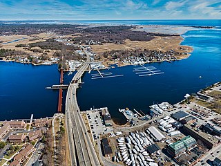
The Merrimack River is a 117-mile-long (188 km) river in the northeastern United States. It rises at the confluence of the Pemigewasset and Winnipesaukee rivers in Franklin, New Hampshire, flows southward into Massachusetts, and then flows northeast until it empties into the Gulf of Maine at Newburyport. From Pawtucket Falls in Lowell, Massachusetts, onward, the Massachusetts–New Hampshire border is roughly calculated as the line three miles north of the river.

The Intracoastal Waterway (ICW) is a 3,000-mile (4,800 km) inland waterway along the Atlantic and Gulf of Mexico coasts of the United States, running from Boston, Massachusetts, southward along the Atlantic Seaboard and around the southern tip of Florida, then following the Gulf Coast to Brownsville, Texas. Some sections of the waterway consist of natural inlets, saltwater rivers, bays, and sounds, while others are artificial canals. It provides a navigable route along its length without many of the hazards of travel on the open sea.

Cape Ann is a rocky cape in northeastern Massachusetts, United States on the Atlantic Ocean. It is about 30 miles northeast of Boston and marks the northern limit of Massachusetts Bay. Cape Ann includes the city of Gloucester and the towns of Essex, Manchester-by-the-Sea and Rockport.
Annisquam is a waterfront neighborhood in the city of Gloucester, on the North Shore of Massachusetts. It is a few miles across Cape Ann from downtown Gloucester.
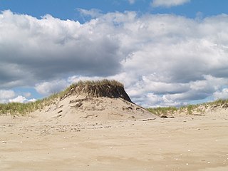
Plum Island is a barrier island located off the northeast coast of Massachusetts, north of Cape Ann, in the United States. It is approximately 11 miles (18 km) in length. The island is named for the wild beach plum shrubs that grow on its dunes, but is also famous for the purple sands at high tide, which get their color from small crystals of pink pyrope garnet. It is located in parts of four municipalities in Essex County. From north to south they are the city of Newburyport, and the towns of Newbury, Rowley, and Ipswich.
Babson Ledge is a small barren rock within the edge of the Western Harbor and Gloucester Harbor in Gloucester, Massachusetts. The rock is situated south of the Fort Point, Pavilion Beach, Blynman Canal, Route 127, and west of Rocky Neck.

Massachusetts's 6th congressional district is located in northeastern Massachusetts. It contains most of Essex County, including the North Shore and Cape Ann, as well as part of Middlesex County. It is represented by Seth Moulton, who has represented the district since January 2015. The shape of the district went through minor changes effective from the elections of 2012 after Massachusetts congressional redistricting to reflect the 2010 census. The towns of Tewksbury and Billerica were added, along with a small portion of the town of Andover.
Chelsea Creek, shown on federal maps as the Chelsea River, is a 2.6-mile-long (4.2 km) waterway that runs along the shore of Chelsea, Massachusetts, and separates that community from the cities of Boston and Revere, as well as feeding part of the current Belle Isle Marsh Reservation that separates Boston from Revere. It is one of 10 designated port areas in Massachusetts.
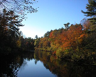
Ipswich River is a small river in northeastern Massachusetts, United States. It held significant importance in early colonial migrations inland from the ocean port of Ipswich. The river provided safe harborage at offshore Plum Island Sound to early Massachusetts subsistence farmers, who were also fishermen. A part of the river forms town boundaries and divides Essex County, Massachusetts on the coast from the more inland Middlesex County. It is 35 miles (56 km) long, and its watershed is approximately 155 square miles (401 km2), with an estimated population in the area of 160,000 people.
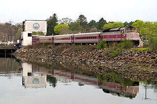
The Newburyport/Rockport Line is a branch of the MBTA Commuter Rail system, running northeast from downtown Boston, Massachusetts towards Cape Ann and the Merrimack Valley, serving the North Shore. The first leg, operating via the Eastern Route of the former Boston and Maine Railroad, serves Chelsea, Lynn, Swampscott, Salem, and Beverly. From there, a northern branch continues via the Eastern Route to serve Hamilton, Ipswich, Rowley, and Newburyport, while other trains operate east from Beverly via the Gloucester Branch, serving Manchester, Gloucester, and Rockport. A bicycle coach is offered on the Rockport branch during the summer.
Route 127 is a 26.70-mile-long (42.97 km) north–south Massachusetts state route that runs from Beverly to Gloucester. Much of the northern part of the route is in Cape Ann. Route 127's southern terminus is at Route 1A and the southern terminus of Route 22 in Beverly and the northern terminus is at Route 128 in Gloucester.
Route 133 is a 40.87-mile-long (65.77 km) east–west Massachusetts state route that runs from Route 38 and Route 110 in Lowell to Route 127 in Gloucester.

Wingaersheek Beach is a 0.6-mile (0.97 km) long beach located on the Annisquam River in West Gloucester, Massachusetts, United States.
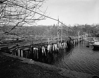
The Annisquam Bridge is a historic bridge in Annisquam, Massachusetts, a village within the city of Gloucester. The bridge was built in 1861 to replace an earlier 1847 bridge that crossed Lobster Cove. It is a wooden pile bridge, a type of which only two others were found in New England as part of a c. 1979 survey. The bridge is 440 feet (130 m) long and 30 feet (9.1 m) wide, and had a drawbridge section in the center that was moved by a hand-cranked winch. The bridge has repeatedly been the subject of safety closings and restorative work over the course of the 20th century, and was completely rebuilt in 1946–7, removing the draw. Despite this, it was closed to vehicular traffic in 1968, and pedestrian traffic in 1987. The bridge has since been rehabilitated, and is open to pedestrian traffic.
The Back River is a small tidal estuary in Bourne, Massachusetts on the eastern shore of Buzzards Bay. It lies just south of the Cape Cod Canal near the village of Monument Beach. It is separated from Buzzards Bay by Phinneys Harbor. The river's length is 2.1 miles (3.4 km).
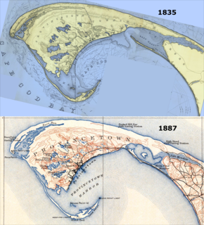
East Harbor is a tidal estuary in Truro, Massachusetts that was originally a harbor until it was cut off from Cape Cod Bay to form a salt marsh lagoon, later renamed Pilgrim Lake. It is now within the Cape Cod National Seashore.


