Wankinco River

Last updated
Wankinco River and environs Wankinco River (Massachusetts) map.jpg
Wankinco River and environs

The Wankinco River is a 7.3-mile-long (11.7 km) [1] river in eastern Massachusetts, United States. It is a tributary of the Wareham River, which drains into Buzzards Bay.

River Natural flowing watercourse

A river is a natural flowing watercourse, usually freshwater, flowing towards an ocean, sea, lake or another river. In some cases a river flows into the ground and becomes dry at the end of its course without reaching another body of water. Small rivers can be referred to using names such as stream, creek, brook, rivulet, and rill. There are no official definitions for the generic term river as applied to geographic features, although in some countries or communities a stream is defined by its size. Many names for small rivers are specific to geographic location; examples are "run" in some parts of the United States, "burn" in Scotland and northeast England, and "beck" in northern England. Sometimes a river is defined as being larger than a creek, but not always: the language is vague.

Massachusetts State of the United States of America

Massachusetts, officially the Commonwealth of Massachusetts, is the most populous state in the New England region of the northeastern United States. It borders on the Atlantic Ocean to the east, the states of Connecticut and Rhode Island to the south, New Hampshire and Vermont to the north, and New York to the west. The state is named after the Massachusett tribe, which once inhabited the east side of the area, and is one of the original thirteen states. The capital of Massachusetts is Boston, which is also the most populous city in New England. Over 80% of Massachusetts's population lives in the Greater Boston metropolitan area, a region influential upon American history, academia, and industry. Originally dependent on agriculture, fishing and trade, Massachusetts was transformed into a manufacturing center during the Industrial Revolution. During the 20th century, Massachusetts's economy shifted from manufacturing to services. Modern Massachusetts is a global leader in biotechnology, engineering, higher education, finance, and maritime trade.

Although now spelled Wankinco, it was previously written as Wankinquoah, which may have been derived from Wonqun, meaning "crooked".

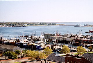
The river originates at East Head Reservoir, a pond in the Myles Standish State Forest, and flows southwards through various impoundments and cranberry bogs to join the Agawam River near the center of Wareham, Massachusetts, after which it forms the Wareham River, forming Wareham's main harbor with a depth of about 12 feet (3.7 m). During a portion of its course, it serves as the boundary between Carver and Plymouth, Massachusetts.

East Head Reservoir, also known as East Head Pond, is a 92-acre (370,000 m2) pond in Carver and Plymouth, Massachusetts, within the Myles Standish State Forest, located northeast of the forest headquarters, east of Barrett Pond, southwest of New Long Pond and College Pond, and northwest of Fearing Pond. The reservoir is the headwaters to the Wankinco River.

Myles Standish State Forest

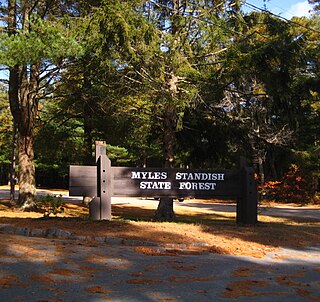
Myles Standish State Forest is state forest located in the towns of Plymouth and Carver in southeastern Massachusetts, approximately 45 miles (70 km) south of Boston. It is the largest publicly owned recreation area in this part of Massachusetts and is managed by the Department of Conservation and Recreation (DCR).

Cranberry subgenus of plants

Cranberries are a group of evergreen dwarf shrubs or trailing vines in the subgenus Oxycoccus of the genus Vaccinium. In Britain, cranberry may refer to the native species Vaccinium oxycoccos, while in North America, cranberry may refer to Vaccinium macrocarpon. Vaccinium oxycoccos is cultivated in central and northern Europe, while Vaccinium macrocarpon is cultivated throughout the northern United States, Canada and Chile. In some methods of classification, Oxycoccus is regarded as a genus in its own right. They can be found in acidic bogs throughout the cooler regions of the Northern Hemisphere.

Related Research Articles

Plymouth County, Massachusetts County in the United States

Plymouth County is a county in the U.S. state of Massachusetts. As of the 2010 census, the population was 494,919. Its county seats are Plymouth and Brockton. In 1685 the County was created by the Plymouth General Court, the legislature of Plymouth Colony, predating its annexation by the Massachusetts Bay Colony.

Buzzards Bay, Massachusetts Census-designated place in Massachusetts, United States

Buzzards Bay is a census-designated place (CDP) in the town of Bourne in Barnstable County, Massachusetts. The population was 3,859 at the 2010 census. It is the most populous of the five CDPs in Bourne.

Carver, Massachusetts Town in Massachusetts, United States

Carver is a town in Plymouth County, Massachusetts, United States. The population was 11,509 at the 2010 census. It is named for John Carver, the first governor of the Plymouth Colony. The town features two popular tourist attractions: Edaville USA theme park and King Richard's Faire, the largest and longest-running renaissance fair in New England.

Wareham, Massachusetts Town in Massachusetts, United States

Wareham is a town in Plymouth County, Massachusetts, United States. As of the 2010 census, the town had a population of 21,822. Wareham has long been recognized as not part of Cape Cod.

Bourne, Massachusetts Town in Massachusetts, United States

Bourne is a town in Barnstable County, Massachusetts, United States. The population was 19,754 at the 2010 census.

Cape Cod Bay A large bay of the Atlantic Ocean adjacent to the U.S. state of Massachusetts

Cape Cod Bay is a large bay of the Atlantic Ocean adjacent to the U.S. state of Massachusetts. Measuring 604 square miles (1,560 km2) below a line drawn from Brant Rock in Marshfield to Race Point in Provincetown, Massachusetts, it is enclosed by Cape Cod to the south and east, and Plymouth County, Massachusetts, to the west. To the north of Cape Cod Bay lie Massachusetts Bay and the Atlantic Ocean. Cape Cod Bay is the southernmost extremity of the Gulf of Maine. Cape Cod Bay is one of the bays adjacent to Massachusetts that give it the name Bay State. The others are Narragansett Bay, Buzzards Bay, and Massachusetts Bay.

Abiels Ledge island in Plymouth County, United States of America

Abiels Ledge is a small barren rock located in Buzzards Bay, within Massachusetts. The rock is just off the southeast coast of Stony Point Dike, near Hog Island Channel and within the town limits of Wareham. This is a good place to catch stripers when they are running.

Massachusettss 9th congressional district

Massachusetts's 9th congressional district is located in eastern Massachusetts. It is represented by Democrat William R. Keating.

South Coast (Massachusetts)

The South Coast of Massachusetts is the region of southeastern Massachusetts consisting of southern Bristol and Plymouth counties bordering Buzzards Bay, and includes the cities of Fall River, New Bedford, the southeastern tip of East Taunton and nearby towns. The term is recent, dating to the 1990s, and sometimes confused with the South Shore.

Old Colony Lines Several train routes that connect Boston, Massachusetts with its southern suburbs.

The Old Colony Lines are branches of the MBTA Commuter Rail system, connecting downtown Boston, Massachusetts with the South Shore and cranberry-farming country to the south and southeast. The Middleborough/Lakeville Line winds south through Holbrook, Brockton, Bridgewater, Middleborough, and Lakeville, and the Kingston/Plymouth Line heads southeast from Braintree, roughly following Route 3, toward Weymouth, Abington, Whitman, Hanson, Halifax, Kingston, and Plymouth. The Greenbush Line, part of the original Old Colony system but restored separately, heads east from north of Braintree station towards Hingham, Cohasset, and Scituate. In fiscal year 2013, the Middleborough/Lakeville line averaged 7,182 and the Kingston/Plymouth Line 6,560 one-way riders per weekday, for a combined daily ridership of 13,742 - a substantial decrease from daily averages exceeding 19,000 several years before.

This article shows U.S. Census totals for Plymouth County, Massachusetts, broken down by municipality, from 1900 to 2010.

Sippican River river in the United States of America

The Sippican River is a short river in Massachusetts, United States.

Southeastern Massachusetts Region of Massachusetts in the United States

Southeastern Massachusetts consists of those portions of Massachusetts that are, by their proximity, economically and culturally linked to Providence, Rhode Island as well as Boston. Despite the location of Cape Cod and the islands to its south, which are the southeasternmost parts of the state, they are not always grouped in this designation. At its broadest definition, it includes all of Massachusetts south of Boston and southeast of Worcester.

Agawam River river in the United States of America

The Agawam River is a 10.7-mile-long (17.2 km) stream in southeastern Massachusetts, USA, that is part of the Wareham River estuary watershed. The Agawam River is named in honor of the peaceful Native Americans that helped the Massachusetts Bay Colony establish its first Connecticut River Valley settlement at Springfield, Massachusetts in 1636, and helped it to flourish while many of the Connecticut Colony settlements south of Springfield were attacked or destroyed by more war-like Native American tribes.

Pocasset River (Massachusetts) river in the United States of America

The Pocasset River is a small tidal river and estuary on the eastern shore of Buzzards Bay, in Bourne, Massachusetts, United States. It is located between the villages of Monument Beach and Pocasset along the western coast of Cape Cod. The river flows westward through a series of small ponds and wetlands, with a total length of about 2 miles (3.2 km).

Weweantic River river in the United States of America

The Weweantic River is a 17.0-mile-long (27.4 km) river in southeastern Massachusetts. Its name means "crooked" or "wandering stream" in the Wampanoag language.

Rose Point is a very small peninsula located in the town of Wareham, Massachusetts, United States. It is formed by the splitting of the Sippican River into the Weweantic River.

The Lyman Reserve is a 210-acre (0.85 km2) nature reserve in Bourne, Plymouth and Wareham, Massachusetts and is managed by the Trustees of Reservations. There are 1.5 miles (2.4 km) of hiking trails, a beach and is in proximity to the Red Brook Reserve and Red Brook Wildlife Management Area. The area was formerly as private fishing camp, which sits at the mouth of Red Brook at Buttermilk Bay. It is home to one of the last remaining groups of sea-run brook trout ("salters") in the Eastern United States.

The Back River is a small tidal estuary in Bourne, Massachusetts on the eastern shore of Buzzards Bay. It lies just south of the Cape Cod Canal near the village of Monument Beach. It is separated from Buzzards Bay by Phinneys Harbor. The river's length is 2.1 miles (3.4 km).

Buttermilk Bay is a neighborhood located in the Plymouth, Massachusetts village of South Plymouth. Buttermilk Bay is a small neighborhood located between Massachusetts Route 25, Red Brook Road/Head of the Bay Road, and Buzzards Bay. The Buttermilk Bay neighborhood is located off Red Brook Road/Head of the Bay Road just on the outskirts of Buzzards Bay, a village of Bourne, Massachusetts. Buttermilk Bay is the southernmost point of Plymouth, Massachusetts.

References

  1. U.S. Geological Survey. National Hydrography Dataset high-resolution flowline data. The National Map, accessed April 1, 2011

Coordinates: 41°45′24″N70°42′45″W / 41.75667°N 70.71250°W / 41.75667; -70.71250

Geographic coordinate system Coordinate system

A geographic coordinate system is a coordinate system that enables every location on Earth to be specified by a set of numbers, letters or symbols. The coordinates are often chosen such that one of the numbers represents a vertical position and two or three of the numbers represent a horizontal position; alternatively, a geographic position may be expressed in a combined three-dimensional Cartesian vector. A common choice of coordinates is latitude, longitude and elevation. To specify a location on a plane requires a map projection.