


The Westport River lies between Narragansett Bay and Buzzards Bay in Westport, Massachusetts.
The Westport River lies between Narragansett Bay and Buzzards Bay in Westport, Massachusetts.
The Westport River has two branches. The smaller West Branch is approximately 7.0 miles (11.3 km) long, [1] rising from a confluence of brooks near the village of Adamsville, Rhode Island. It flows in a southeastward direction, passing around several small islands before meeting Westport Harbor west of Westport Point. The West Branch separates the village of Acoaxet (pronounced "a-KOKE-sett") from the rest of the town; one has to pass into Rhode Island in order to reach the rest of Westport from there by land.
The larger East Branch is roughly 11.5 miles (18.5 km) long, [1] rising at the town line of Westport and Dartmouth at Lake Noquochoke, which is fed mostly by the Copicut and Shingle Island rivers. After a short length the river meets the Bread and Cheese Brook before reaching the Head of Westport village, where the river widens and deepens. From here the river continues southward, being fed by several brooks before an initial widening to between 100-400 yards at Widows Point. From Widows Point, the river flows due southward, crossing under the Hix Bridge before passing Gull Rock and then widening at Cadman's Neck to approximately a half mile wide. The river flows southward, with several larger islands dotting the path, before meeting the Horseneck Channel (which in turn leads to The Let) at Westport Point. The East Branch then flows under the Normand Edward Fontaine Bridge and into Westport Harbor.
Once in Westport Harbor, the combined branches bend around Horseneck Point across from The Knubble before flowing into Rhode Island Sound, just west of Horseneck Beach State Reservation and the point where Rhode Island Sound meets Buzzards Bay.
The Westport River estuary has long been known for its wildlife. Deer, coyotes, foxes, and turkeys can all be spotted at different times along the shore. Ospreys are very prevalent. There were 41 nesting sites confirmed in 1980. Now the population has spread to over 300 statewide, due to the Westport River estuary nesting program. MassWildlife continues to provide technical assistance to monitor a sample of the nesting population to determine productivity.

Westport is a town in Bristol County, Massachusetts, United States. The population was 16,339 at the 2020 census.

Narragansett Bay is a bay and estuary on the north side of Rhode Island Sound covering 147 square miles (380 km2), 120.5 square miles (312 km2) of which is in Rhode Island. The bay forms New England's largest estuary, which functions as an expansive natural harbor and includes a small archipelago. Small parts of the bay extend into Massachusetts.

The Hackensack River is a river, approximately 45 miles (72 km) long, in the U.S. states of New York and New Jersey, emptying into Newark Bay, a back chamber of New York Harbor. The watershed of the river includes part of the suburban area outside New York City just west of the lower Hudson River, which it roughly parallels, separated from it by the New Jersey Palisades. It also flows through and drains the New Jersey Meadowlands. The lower river, which is navigable as far as the city of Hackensack, is heavily industrialized and forms a commercial extension of Newark Bay. Once believed to be among the most polluted watercourses in the United States, it staged a modest revival by the late 2000s. The river is divided into the upper river, north of the Oradell Reservoir and Oradell Dam, and lower river, south of the reservoir and dam.

Tampa Bay is a large natural harbor and shallow estuary connected to the Gulf of Mexico on the west-central coast of Florida, comprising Hillsborough Bay, McKay Bay, Old Tampa Bay, Middle Tampa Bay, and Lower Tampa Bay. The largest freshwater inflow into the bay is the Hillsborough River, which flows into Hillsborough Bay in downtown Tampa. Many other smaller rivers and streams also flow into Tampa Bay, resulting in a large watershed area.

The Assonet River is located in Bristol County, Massachusetts. It flows 7.4 miles (11.9 km) in a westerly direction through Freetown and joins the Taunton River near Assonet Neck in Berkley, Massachusetts.

The Pawcatuck River is a river in the US states of Rhode Island and Connecticut flowing approximately 34 miles (55 km). There are eight dams along the river's length. USS Pawcatuck was named after the river.

The Normand Edward Fontaine Bridge is a 1,025 feet (312 m)-long bascule bridge at 41.517258°N 71.06799°W in Westport, Massachusetts, USA. Two lanes of Route 88 pass over the bridge from Westport Point and Wood Point in the Westport Point section of town to the Horseneck Beach State Reservation, connecting with Cherry & Webb Lane and, eventually, John Reed Road when Route 88 officially ends 0.3 miles south of the bridge's southern end.

Route 88 is a 11.30-mile-long (18.19 km) north–south state highway in the town of Westport in southeastern Massachusetts. At just over 11 miles, it is the longest Massachusetts state route to be situated in only one town. It begins at John Reed Road and ends at an interchange with I-195.

Horseneck Beach State Reservation is a public recreation area comprising more than 800 acres (320 ha) on the Atlantic Ocean in the southern portion of the town of Westport, Massachusetts. The reservation is one of the state’s "most popular facilities ... welcom[ing] hundreds of thousands of visitors per year." It is managed by the Massachusetts Department of Conservation and Recreation.
Grays Harbor is an estuarine bay located 45 miles (72 km) north of the mouth of the Columbia River, on the southwest Pacific coast of Washington state, in the United States of America. It is a ria, which formed at the end of the last ice age, when sea levels flooded the Chehalis River. The bay is 17 miles (27 km) long and 12 miles (19 km) wide. The Chehalis River flows into its eastern end, where the city of Aberdeen stands at that river's mouth, on its north bank, with the somewhat smaller city of Hoquiam immediately to its northwest, along the bayshore. Besides the Chehalis, many lesser rivers and streams flow into Grays Harbor, such as Hoquiam River and Humptulips River. A pair of low peninsulas separate it from the Pacific Ocean, except for an opening about two miles (3 km) in width. The northern peninsula, which is largely covered by the community of Ocean Shores, ends in Point Brown. Facing that across the bay-mouth is Point Chehalis, at the end of the southern peninsula upon which stands the town of Westport.

The Acushnet River is the largest river, 8.6 miles (13.8 km) long, flowing into Buzzards Bay in southeastern Massachusetts, in the United States. The name "Acushnet" comes from the Wampanoag or Algonquian word, "Cushnea", meaning "as far as the waters", a word that was used by the original owners of the land in describing the extent of the parcel they intended to sell to the English settlers from the nearby Plimouth colony. Quite naturally, the English mistook "Cushnea" for a fixed placename or the name of a specific river.

The Barrington River is a tidal extension of Runnins River in the U.S. states of Rhode Island and Massachusetts. It flows approximately 6 km (4 mi). There are no dams along the river's length.

Mount Hope Bay is a tidal estuary located at the mouth of the Taunton River on the Massachusetts and Rhode Island border. It is an arm of Narragansett Bay. The bay is named after Mount Hope, a small hill located on its western shore in what is now Bristol, Rhode Island. It flows into the East Passage of Narragansett Bay and also the Sakonnet River. Mount Hope Bay has played an important role to the history of the area, from pre-colonial times to the present. While many years of sewage and industrial pollution have severely degraded the quality of the shallow waters of the bay, there are currently major efforts underway to clean up and restore it.
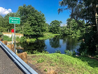
The Palmer River is a river in the U.S. states of Massachusetts and Rhode Island. It flows approximately 17 km (11 mi).

The North Branch Pawtuxet River is a river in the U.S. state of Rhode Island. It flows approximately 8.9 miles (14.3 km). There are 9 dams along the river's length.
The South Branch Pawtuxet River is a river in the U.S. state of Rhode Island. It flows approximately 9.8 miles (15.8 km). There are 11 dams along the river's length.

The Watuppa Ponds are two large, naturally occurring, spring-fed, glacially formed ponds located in Fall River and Westport, Massachusetts. Watuppa is a native word meaning "place of boats". The two ponds were originally one body of water, connected by a narrow rocky straight called "The Narrows" located on a thin strip of land between the two ponds which forms part boundary of between Fall River and Westport. The border between Fall River and Westport is also divided between the two ponds. Together, the ponds have an overall north–south length of about 7.5 miles, and have an average east–west width of about a mile. The ponds are drained by the Quequechan River, and flows in a westerly direction through the center of Fall River from South Watuppa Pond to Mount Hope Bay.

The Sheepscot River is a 66-mile-long (106 km) river in the U.S. state of Maine. Its lower portion is a complex island estuary with connections to the Kennebec River downstream of Merrymeeting Bay.
Sandy Point Island is a 35-acre (14 ha) island in Little Narragansett Bay, lying mostly in Westerly, Rhode Island and partly in Stonington, Connecticut. Once an extension of Napatree Point, Sandy Point is now a one-mile-long (1.6 km) island that serves as an important nature preserve and recreation site. Sandy Point is the westernmost piece of land in the state of Rhode Island.