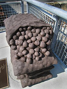
The Big Dig was a megaproject in Boston that rerouted the then elevated Central Artery of Interstate 93 that cut across Boston into the O'Neill Tunnel and built the Ted Williams Tunnel to extend Interstate 90 to Logan International Airport. Those two projects were the origin of the official name, the Central Artery/Tunnel Project. Additionally, the project constructed the Zakim Bunker Hill Bridge over the Charles River, created the Rose Kennedy Greenway in the space vacated by the previous I-93 elevated roadway, and funded more than a dozen projects to improve the region's public transportation system. Planning for the project began in 1982; the construction work was carried out between 1991 and 2006; and the project concluded on December 31, 2007. The project's general contractor was Bechtel and Parsons Brinckerhoff was the engineer, who worked as a consortium, both overseen by the Massachusetts Highway Department.

The Leonard P. ZakimBunker Hill Memorial Bridge is a cable-stayed bridge completed in 2003 across the Charles River in Boston, Massachusetts. It is a replacement for the Charlestown High Bridge, an older truss bridge constructed in the 1950s.

Transportation in Boston includes roadway, subway, regional rail, air, and sea options for passenger and freight transit in Boston, Massachusetts. The Massachusetts Port Authority (Massport) operates the Port of Boston, which includes a container shipping facility in South Boston, and Logan International Airport, in East Boston. The Massachusetts Bay Transportation Authority (MBTA) operates bus, subway, short-distance rail, and water ferry passenger services throughout the city and region. Amtrak operates passenger rail service to and from major Northeastern cities, and a major bus terminal at South Station is served by varied intercity bus companies. The city is bisected by major highways I-90 and I-93, the intersection of which has undergone a major renovation, nicknamed the Big Dig.
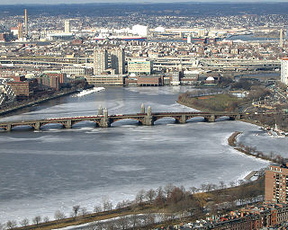
The Charles River, sometimes called the River Charles or simply the Charles, is an 80-mile-long (129 km) river in eastern Massachusetts. It flows northeast from Hopkinton to Boston along a highly meandering route, that doubles back on itself several times and travels through 23 cities and towns before reaching the Atlantic Ocean. The indigenous Massachusett named it Quinobequin, meaning "meandering" or "meandering still water".

Charlestown is the oldest neighborhood in Boston, Massachusetts, in the United States. Also called Mishawum by the Massachusett, it is located on a peninsula north of the Charles River, across from downtown Boston, and also adjoins the Mystic River and Boston Harbor waterways. Charlestown was laid out in 1629 by engineer Thomas Graves, one of its earliest settlers, during the reign of Charles I of England. It was originally a separate town and the first capital of the Massachusetts Bay Colony.

Alewife station is a Massachusetts Bay Transportation Authority (MBTA) intermodal transit station in the North Cambridge neighborhood of Cambridge, Massachusetts. It is the northwest terminal of the rapid transit Red Line and a hub for several MBTA bus routes. The station is at the confluence of the Minuteman Bikeway, Alewife Linear Park, Fitchburg Cutoff Path, and Alewife Greenway off Alewife Brook Parkway adjacent to Massachusetts Route 2, with a five-story parking garage for park and ride use. The station has three bike cages. Alewife station is named after nearby Alewife Brook Parkway and Alewife Brook, themselves named after the alewife fish.

Charles/MGH station is a rapid transit station on the MBTA Red Line, elevated above Charles Circle on the east end of the Longfellow Bridge in the West End neighborhood of Boston, Massachusetts. The station is named for Charles Circle and the adjacent Massachusetts General Hospital (MGH) campus. It has two side platforms, with a glass-walled headhouse structure inside Charles Circle. Charles/MGH station is fully accessible.

Science Park station is an elevated light rail station on the Massachusetts Bay Transportation Authority (MBTA) Green Line in Boston, Massachusetts, United States. The station is located at the Boston end of the Charles River Dam Bridge at Leverett Circle. It is at the southeast end of the Lechmere Viaduct, which carries the Green Line over the Charles River. The station is named for the nearby Boston Museum of Science. With 873 daily boardings by a FY 2019 count, Science Park is the least-used fare-controlled station on the Green Line, and the second-lowest on the MBTA subway system after Suffolk Downs.
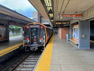
Sullivan Square station is a rapid transit station on the MBTA subway Orange Line, located adjacent to Sullivan Square in the Charlestown neighborhood of Boston, Massachusetts. It is a major transfer point for MBTA bus service, with 10 routes using a two-level busway. The station has two island platforms serving the two active Orange Line tracks plus an unused third track. The Haverhill Line and Newburyport/Rockport Line pass through the station on separate tracks but do not stop.

The Fitchburg Railroad is a former railroad company, which built a railroad line across northern Massachusetts, United States, leading to and through the Hoosac Tunnel. The Fitchburg was leased to the Boston and Maine Railroad in 1900. The main line from Boston to Fitchburg is now operated as the MBTA Fitchburg Line; Pan Am Railways runs freight service on some other portions.

The Mass Central Rail Trail (MCRT) is a partially completed rail trail between Northampton, Massachusetts and Boston along the right-of-way (ROW) of the former Massachusetts Central Railroad and former Central Massachusetts Railroad. It currently has over 60 miles (97 km) open, and 94.5 miles (152.1 km) are open or protected for trail development. When complete, it will be 104 miles (167 km) long through Central Massachusetts and Greater Boston, forming the longest rail trail in New England. Many sections of the trail, including the Norwottuck Branch of the Mass Central Rail Trail and the Somerville Community Path, have been developed as separate projects but serve as part of the complete Mass Central Rail Trail. The Norwottuck Network, a 501(c)(3) nonprofit that supports the build and operation of the MCRT, maintains an interactive map of the MCRT and other Massachusetts trails.

Community College station is a rapid transit station on the MBTA Orange Line in Boston, Massachusetts. It is located in the Charlestown neighborhood off Austin Street near New Rutherford Avenue (MA-99), under the double-decked elevated structure carrying Interstate 93 to the Zakim Bunker Hill Bridge. The station is named for the adjacent Bunker Hill Community College. The station opened in April 1975, replacing the City Square and Thompson Square stations of the Charlestown Elevated. It was made accessible around 2005.
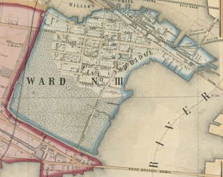
East Cambridge is a neighborhood of Cambridge, Massachusetts. East Cambridge is bounded by the Charles River and the Charlestown neighborhood of Boston on the east, the Somerville border on the north, Broadway and Main Street on the south, and the railroad tracks on the west. Most of the streets form a grid aligned with Cambridge Street, which was laid out to directly connect what is now the Charles River Dam Bridge with what in 1809 was the heart of Cambridge, Harvard Square. The northern part of the grid is a roughly six by eight block residential area. Cambridge Street itself is retail commercial, along with Monsignor O'Brien Highway, the Twin Cities Plaza strip mall, and the enclosed Cambridgeside Galleria. Lechmere Square is the transportation hub for the northern side. The southern half of the grid is largely office and laboratory space for hundreds of dot-com companies, research labs and startups associated with MIT, biotechnology firms including Genzyme, Biogen and Moderna, the Athenaeum Press Building, light industry, an NRG Energy power station, and various small businesses. This half of the neighborhood is generally identified with Kendall Square. Along the waterfront are several hotels and taller apartment buildings.

Storrow Drive, officially James Jackson Storrow Memorial Drive, is a major crosstown parkway in Boston, Massachusetts, running east–west along the southern bank of the Charles River. It is restricted to cars; trucks and buses are not permitted on it, while pedestrian access is available via walking paths on the Charles River side of the road. Boston drivers use the route for quick access to downtown locations.
The Haymarket North Extension is a section of the Massachusetts Bay Transportation Authority's rapid transit Orange Line which currently constitutes the northern section of the line. It runs from North Station through an underground crossing of the Charles River, then along the Haverhill Line right-of-way to Oak Grove station in Malden, Massachusetts. Built to replace the Charlestown Elevated and originally intended to be extended as far as Reading, it opened in stages between 1975 and 1977.

North Point Park is an 8.5-acre (3.4 ha) park located along the left bank of the Charles River on the border of Cambridge and Boston, Massachusetts, created as mitigation for the taking of planned parkland for the construction of the Big Dig.

Boston Harborwalk is a public walkway that follows the edge of piers, wharves, beaches, and shoreline around Boston Harbor. When fully completed it will extend a distance of 47 miles (76 km) from East Boston to the Neponset River.

The Green Line Extension (GLX) was a construction project to extend the Massachusetts Bay Transportation Authority (MBTA) Green Line light rail system northwest into Somerville and Medford, two inner suburbs of Boston, Massachusetts. The project opened in two phases in 2022 at a total cost of $2.28 billion. Total ridership on the 4.3-mile (6.9 km) extension is estimated to reach 45,000 one-way trips per day in 2030.

Paul Revere Park is a five-acre (2.0 ha) park located on the Charles River in Charlestown, Massachusetts. The park was the first park to open along the "Lost Half Mile" of the Charles River as mitigation for the taking of planned parkland for the construction of the Big Dig. The park runs along the Charles River between the Freedom Trail on North Washington Street and the Leonard P. Zakim Bunker Hill Memorial Bridge. The park features a large oval-shaped lawn, an informal performance area, and a playground.

The North Bank Bridge is a pedestrian and bicycle bridge on the north bank of the Charles River in Massachusetts. It connects North Point Park in Cambridge with Paul Revere Park in the Charlestown area of Boston, two parks which were created as mitigation efforts for Boston’s Big Dig. It is a segment of the Mass Central Rail Trail and the East Coast Greenway.