
The Egyptian language, or Ancient Egyptian, is an extinct branch of the Afro-Asiatic languages that was spoken in ancient Egypt. It is known today from a large corpus of surviving texts, which were made accessible to the modern world following the decipherment of the ancient Egyptian scripts in the early 19th century.

Rowley is a census-designated place (CDP) in the town of Rowley in Essex County, Massachusetts, United States. The population was 1,416 at the 2010 census.
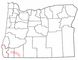
The Rogue Valley is a valley region in southwestern Oregon in the United States. Located along the middle Rogue River and its tributaries in Josephine and Jackson counties, the valley forms the cultural and economic heart of Southern Oregon near the California border. The largest communities in the Rogue Valley are Medford, Ashland and Grants Pass. The most populated part of the Rogue Valley is not along the Rogue proper, but along the smaller Bear Creek tributary. The Rogue Valley is a popular fall destination in Oregon because of the hardwood forests there.

Byfield is a village in the town of Newbury, in Essex County, Massachusetts, United States. It borders West Newbury, Georgetown, and Rowley. It is located approximately 30 miles north-northeast of Boston, along Interstate 95, about 10 miles south of the border between New Hampshire and Massachusetts. The ZIP Code for Byfield is 01922.
The Matfield River is a 6.3-mile-long (10.1 km) river in Plymouth County, Massachusetts. It flows south through the town of East Bridgewater to a confluence with the Town River, forming the Taunton River. The Matfield River, where it flows through the historic village of Elmwood and flows under Route 18, is commonly known as the Elmwood River.
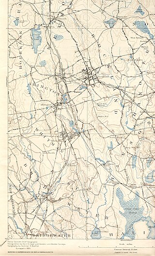
The Satucket River is 5.5-mile-long (8.9 km) river in southeastern Massachusetts within the Taunton River Watershed. It flows generally west from Robbins Pond in East Bridgewater, and into the Matfield River.

Massachusetts's 6th congressional district is located in northeastern Massachusetts. It contains most of Essex County, including the North Shore and Cape Ann, as well as part of Middlesex County. It is represented by Seth Moulton, who has represented the district since January 2015. The shape of the district went through minor changes effective from the elections of 2012 after Massachusetts congressional redistricting to reflect the 2010 census. The towns of Tewksbury and Billerica were added, along with a small portion of the town of Andover.
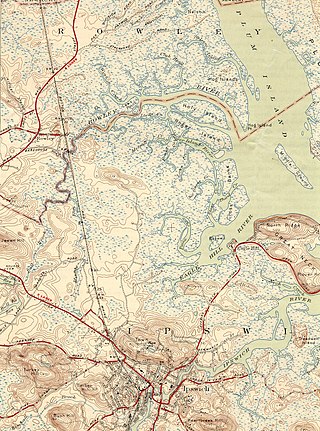
The Rowley River is a small river between Ipswich and Rowley, Massachusetts.

Mashpee River Reservation is a park in Mashpee, Massachusetts on the Mashpee River. The Trustees of Reservations owns and maintains the park.
The Shumatuscacant River is an 8.8-mile-long (14.2 km) river running through Abington and Whitman, Massachusetts. It forms part of the Taunton River Watershed.
The Roger Island River is a small tidal estuary between Ipswich and Rowley, Massachusetts. It is a southern branch of the larger Rowley River passing around Roger Island.
The Saugus River is a river in Massachusetts.

Weymouth Fore River is a small bay or estuary in eastern Massachusetts and is part of the Massachusetts Bay watershed.
Holy Island is a marshy island located off the northeast coast of Massachusetts, north of Cape Ann. The island is situated immediately west of Plum Island and is part of the Town of Ipswich in Essex County. The Rowley River runs by the island, which is the northernmost of four marshy islands.

The Misery Islands are an 87-acre (350,000 m2) nature reserve established in 1935 in Salem Sound close to the Salem Harbor in Salem, Massachusetts. It is managed by the Trustees of Reservations. The islands are a part of the city of Salem, although they are much closer to the mainland of the city of Beverly, in whose aquatic territory they lie.
Grape Island, sometimes known as Grape Island, Ipswich, is a part of Plum Island, in Ipswich, Massachusetts, in the United States. For nearly two centuries, Grape Island was a small, but thriving community of fishermen, farmers, and clam diggers, until the land was purchased by the US Government and turned into a wildlife refuge in the middle of the 20th century. Its last resident was Lewis Kilborn, who lived his entire life on the island until his death in 1984.

The Essex Institute (1848–1992) in Salem, Massachusetts, was "a literary, historical and scientific society." It maintained a museum, library, historic houses; arranged educational programs; and issued numerous scholarly publications. In 1992 the institute merged with the Peabody Museum of Salem to form the Peabody Essex Museum.

Weir River is a short stream and estuary that empties into Hingham Bay, part of Boston Harbor in Massachusetts, United States. The name is attributed to the location of a fishing weir in the stream. The river gives its name to a larger watershed and Weir River Farm, a park and nature reserve owned by The Trustees of Reservations.

The Artichoke River, is a tributary of the Merrimack River in Massachusetts in the United States. It is in Essex County, Massachusetts, and flows generally north, marking the boundary between West Newbury and Newburyport. The Upper and Lower Artichoke reservoirs are impoundments of the river that acts as a water source for nearby towns. Despite the short length of the river, there are three dams along its course, the Emory Lane Dam, the Lower Artichoke Dam and the Upper Artichoke Dam. The river is named for the Jerusalem Artichoke, which had been harvested nearby by Native Americans and early settlers.
Bradstreet Farm in Rowley, Mass. is believed to be the second-oldest continually operating farm in the U.S. Originally deeded by King Charles I of England to Humphrey Bradstreet in 1635, the property remained in the Bradstreet Family for many generations until 2007, when the Town of Rowley purchased the 120-acre parcel including a 19th century farmhouse and 18th century barn. The Town set aside 103 acres as conservation land, and sold seven acres including the farmhouse and barn as a private residence with historic preservation restrictions. The property is listed on the National Register of Historic Places.